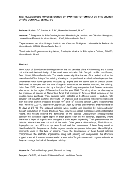
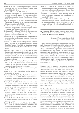
86
Neotropical Primates 11(2), August 2003
Young, A. L. 1983. Preliminary observations on the ecology and behavior of the muriqui and brown howler
monkey. Tese de Bacharelado, Harvard University,
Cambridge, MA.
Zunino, G. E. 1986. Algunos aspectos de la ecología y
etología del mono aullador negro (Alouatta caraya) en
habitats fragmentados. Tese de Doutorado, Facultad de
Ciencias Exatas y Naturales de la Universidad de Buenos
Aires, Buenos Aires.
CALLITHRIX GEOFFROYI (PRIMATES: CALLITRICHIDAE)
AND ALOUATTA CARAYA (PRIMATES: ATELIDAE)
IN THE SERRA DO CIPÓ NATIONAL PARK, MINAS
GERAIS, BRAZIL
Leonardo de Carvalho Oliveira
Edeltrudes Maria V. C. Câmara
André Hirsch, Ana Maria Oliveira Paschoal
Rodrigo Martins Alvarenga, Maycon G. Belarmino
Introduction
The Serra do Cipó National Park is 90 km north of Belo
Horizonte, Minas Gerais, and part of the southern section
of the Serra do Espinhaço (19°12’ to 19°34’S, 43°27’ to
43°38’W). It is 33,800 ha in size, covering altitudes ranging
from 800 to 1600 m. The vegetation is a mix of cerrado (bush
savanna), campo rupestre (rocky moorland), open pasture and
gallery forests, with some forest patches on the eastern ridge.
Here we report unusual high-altitude sightings, made as part
of an ongoing project, of two eastern Brazilian primate species: Callithrix geoffroyi and Alouatta caraya.
Geoffroy’s marmoset, Callithrix geoffroyi (É. Geoffroy in
Humboldt, 1812), is endemic to the Atlantic forest of
Brazil (Rylands et al., 1993; Fonseca et al., 1996). It is
found in secondary forests in lowlands, semi-deciduous
forests, gallery forest and forest borders, with a preference for disturbed rather than mature areas (Passamani
and Rylands, 2000a, 2000b). It is diurnal, and its diet is
composed largely of fruits, exudates and small animal prey.
Populations of Geoffroy’s marmoset are declining over large
parts of its relatively restricted range due to habitat loss and
fragmentation, hunting and capture for pets. Its distribution
appears to be further limited by its restriction, in many parts
of its range, to altitudes between sea level and 600-800 m
(Mendes, 1997).
The black howler monkey, Alouatta caraya (Humboldt,
1812) is typical of the Cerrado biome, but may also be
found in forests along the Paraná/Paranaíba rivers, in deciduous forests in Caatinga regions of north-east Brazil,
semi-deciduous forests of the Pantanal, the humid Chaco of
Argentina, and in “capões” – forest patches – of Rio Grande
do Sul and extreme northwestern Uruguay (Hirsch et al.,
2002). This species thus has a wide geographic range, from
northern Argentina to the northeast of Brazil. A. caraya is
usually to be found in low altitudes up to approximately
1000 m. It is diurnal and lives in groups of seven to nine
individuals, although group sizes of up to 17 have been reported (Bicca-Marques, 1992). Leaves and fruits comprise
the majority of its diet. Although not directly threatened,
A. caraya suffers from the severe and ongoing fragmentation
of its habitat in the Cerrado. In this context it is critical to
identify new sites where it may occur, each of which will be
important to the long-term survival of this species.
In this report, we register the occurrence of Callithrix
geoffroyi and Alouatta caraya in a small fragment of Atlantic
forest on the eastern border of the Serra do Cipó National
Park, Minas Gerais, Brazil. This new locality is at one of
the highest elevations (1274 and 1254 m, respectively) yet
recorded for these species (Carlos E. V. Grelle, pers. comm.;
Maycon G. Belarmino, unpubl. data, respectively), at the
westernmost limits of the Rio Doce basin, headwaters of
the Rio Santo Antônio (Hirsch et al., 2002; see Fig. 1).
Methods and Results
The study was carried out in a forest fragment with an approximate area of 34.3 ha and a perimeter of approximately
3.22 km, in the municipality of Morro do Pilar, near the
neighboring municipality of Santana do Riacho (see Fig. 1).
Geographic coordinates and altitude were taken with a GPS
device. We used a Landsat 5 TM satellite image (p218/r73,
01/nov/1997; Minas Gerais, DMC/IEF, 2001) to identify
the vegetation in the surrounding areas, and ArcGIS 8.2
software (ESRI, 2001) for calculating the forest fragment’s
contour, area and perimeter. From the examination of the
satellite image done by Hirsch (2003), the study site may
be characterized as a small semi-isolated fragment, linked
on only one side with a gallery forest that follows a small
watercourse downstream. The surroundings are occupied
with rocky moorland and open pasture (Fig. 1).
Two marmosets, Callithrix geoffroyi, were heard and seen in
the forest fragment in August 2002. We later observed 10
individuals there during a return visit in March 2003. The
GPS coordinates taken in the field were 19°15’28”S and
43°31’01”W, and the altitude was 1274 m. On 15 March
2003, two members of the field team observed one individual
of Alouatta caraya in the same forest fragment, at approximately the same coordinates and at an altitude of 1254 m.
All the records were taken ad libitum (Altmann, 1974).
Discussion
Callithrix geoffroyi
Although little studied, the home range of C. geoffroyi
is believed to vary from 20 to 30 ha (Rylands and Faria,
1993). Passamani and Rylands (2000a, 2000b) estimated a
home range of 23.3 ha for a group of 3-5 individuals in a
forest fragment of 110 ha in the state of Espírito Santo. The
record from this study was made in a fragment of approximately 34 ha, which suggests that its area is insufficient to
support more than one group. Considering a circle as the
best shape, the ideal perimeter calculated with the formula
Neotropical Primates 11(2), August 2003
87
Figure 1. Location of the forest fragment where Callithrix geoffroyi and Alouatta caraya were recorded at the Serra do Cipó National Park,
Minas Gerais, Brazil.
provided by Hirsch (2003) for this forest fragment is only
2.08 km. The actual contour (3.22 km) is larger and somewhat irregular, with a considerable edge effect acting on the
interior forest area.
One of the causes of the threatened status of C. geoffroyi is
its relatively restricted distribution in a highly fragmented
environment. Our record of this species at an altitude of
1274 m extends its vertical range by almost 500 m, thereby
indicating that it may be more wide-ranging than previously thought. This is also the westernmost record of the
species in the Rio Doce basin (Hirsch et al., 2002). The
nearest record on the western slopes of the Serra do Cipó
National Park is of Callithrix penicillata, near the park’s
administrative headquarters. Thus, the Serra do Cipó may
be considered a biogeographic divide between these two
marmoset species (Hirsch et al., 2002).
Alouatta caraya
Home range size for the genus Alouatta is reported to
vary from 4.1 to 182 ha (Chiarello, 1993; Palacios and
Rodriguez, 2001). In fragmented landscapes, A. caraya has
been registered in patches of 2 ha (Bicca-Marques, 1992;
Bicca-Marques and Calegaro-Marques, 1995). Their ability to incorporate secondary vegetation in their diet may
explain their capacity to survive in small and degraded areas
(Chiarello, 1994). This observation is one of the highest
altitudes (1254 m) recorded for the species (Maycon G.
Belarmino, pers. obs.), which extends its potential geographical distribution and suggests that new proposals for
population management might be implemented in areas
previously considered unsuitable for the species.
Small and isolated fragments such as this one may not have
sufficient core area to support viable populations of many
species (Zudeima et al., 1996). They may function, however, as an ultimate refuge for many species (Shafer, 1995).
Small populations found in such small refuges may be subject to a series of stochastic processes of demographic, genetic
and environmental origin that may lead them to extinction,
despite measures taken for their conservation (Gilpin and
Soulé, 1986; Brito and Fernandez, 2000). The negative effects of population isolation, especially on small populations,
have already been well-demonstrated in the conservation
literature (see, for example, Meffe and Carol, 1997).
Although small forest fragments cannot support marmoset
or howler populations which are viable in the long-term,
they may serve as “stepping stones” between larger forests,
thereby facilitating gene flow and recolonization through
dispersal and migration. These new records are in a large
protected area, the Serra do Cipó National Park, surrounded by the buffer zone of the Morro da Pedreira Environmental Protection Area. This allows for some hope for the
88
long-term persistence of these populations. Future research
may reveal the conservation relevance of such small fragments and their apparently isolated populations.
Acknowledgements: This study is part of a larger project
assessing mammal communities in the various vegetation formations in the Serra do Cipó National Park. We
thank the Brazilian Institute of Environment and Renewable Natural Resources (IBAMA) for permission to work
in the Serra do Cipó National Park, and for providing
facilities. We also thank our colleagues from the Laboratory of Mammalogy, Museum of Natural Sciences of the
Pontifícia Universidade Católica de Minas Gerais for their
help with fieldwork. Robert Young kindly helped with
the English version of the text and provided most useful
suggestions. Carlos Eduardo de Viveiros Grelle provided
unpublished data on Callithrix geoffroyi. The Fundo de
Incentivo a Pesquisa (Research Fund) of the Pontifícia
Universidade Católica de Minas Gerais (FIP/PUC-Minas)
funded this study.
Leonardo C. Oliveira¹,², Edeltrudes M. V. C. Câmara²,
Rodrigo M. Alvarenga², Ana Maria O. Paschoal², ¹Departamento de Ciências Biológicas and ²Museu de Ciências Naturais, PUC-Minas, Rua Dom José Gaspar 290,
Coração Eucarístico, Belo Horizonte 30535-610, Minas
Gerais, Brazil, Maycon G. Belarmino, Laboratório de Vertebrados, Departamento de Ecologia, Instituto de Biologia,
CCS, Universidade Federal do Rio de Janeiro, Caixa Postal
68020, Rio de Janeiro 21941-590, Rio de Janeiro, Brazil
and André Hirsch, Departamento de Zoologia, Instituto de
Ciências Biológicas, Universidade Federal de Minas Gerais,
Avenida Antônio Carlos 6627, Pampulha, Belo Horizonte
30270-901, Minas Gerais, Brazil. E-mail of first author:
<[email protected]>.
References
Altmann, J. 1974. Observational study of behaviour: Sampling methods. Behaviour 49: 227-267.
Bicca-Marques, J. C. 1992. Drinking behaviour in the
black howler monkey (Alouatta caraya). Folia Primatol.
58: 107-111.
Bicca-Marques, J. C. and Calegaro-Marques, C. 1995. Locomotion of black howlers in a habitat with discontinuous canopy. Folia Primatol. 64: 55-61.
Brazil, IBGE. 1998. Dados Gerais do Brasil, Informações Estatísticas e Geocientíficas. Fundação Instituto Brasileiro de Geografia e Estatística (IBGE), Rio de Janeiro. Website: <http:
//www.ibge.gov.br/informações/territ/perfil/Perfilbr.html>.
Brito, D. and Fernandez, F. A. S. 2000. Dealing with extinction is forever: Understanding the risks faced by small
populations. Ciência e Cultura 52: 161-170.
Chiarello, A. G. 1993. Home range of the brown howler
monkey Alouatta fusca in a forest fragment of southeastern Brazil. Folia Primatol. 60: 173-175.
Chiarello, A. G. 1994. Diet of the brown howler monkey
Alouatta fusca in a semi-deciduous forest fragment of
southeastern Brazil. Primates 35: 25-34.
Neotropical Primates 11(2), August 2003
ESRI. 2001. ArcView GIS v. 8.2. Environmental Systems
Research Institute, Redlands, CA. Website: <http:// www.
esri.com/data/index.html>.
Fonseca, G. A. B. da, Herrmann, G., Leite, Y. L. R., Mittermeier, R. A., Rylands, A. B. and Patton, J. L. 1996. Lista
anotada dos mamíferos do Brasil. Occ. Papers Conserv. Biol.
4: 1-38. Conservation International, Washington, DC.
Gilpin, M. E. and Soulé, M. E. 1986. Minimum viable
populations: Processes of species extinction. In:
Conservation Biology: The Science of Scarcity and
Diversity, M. E. Soulé (ed.), pp.19-34. Sinauer Associates,
Sunderland, MA.
Hirsch, A. 2003. Análise da fragmentação do habitat e
seleção de áreas prioritárias para a conservação dos primatas na bacia do Rio Doce, Minas Gerais, através da aplicação de um Sistema de Informações Geográficas. Doctoral dissertation, Universidade Federal de Minas Gerais,
Belo Horizonte.
Hirsch, A., Dias, L. G., Martins, L. de O., Campos, R.
F., Landau, E. C. and Resende, N. A. T. 2002. BDGEOPRIM – Database of geo-referenced localities of
Neotropical primates. Neotrop. Primates 10(2): 79-84.
Website:
<http://www.icb.ufmg.br/~primatas/home_
bdgeoprim.htm>.
Meffe, G. K. and Carroll, C. R. 1997. Principles of Conservation Biology. 2nd edition. Sinauer Associates, Sunderland, MA.
Mendes, S. L. 1997. Padrões biogeográficos e vocais em
Callithrix do Grupo Jacchus (Primates, Callitrichidae).
Doctoral dissertation, Universidade Estadual de Campinas, Campinas.
Minas Gerais, DMC/IEF. 2001. Cobertura de Imagens de Satélite Landsat 5 do Estado de Minas Gerais. Convênio DMC
/ UFMG. Diretoria de Monitoramento e Controle, Instituto Estadual de Florestas and Departamento de Zoologia,
Universidade Federal de Minas Gerais, Belo Horizonte.
Palacios, E. and Rodriguez, A. 2001. Ranging pattern and
use of space in a group of red howler monkeys (Alouatta
seniculus) in a southeastern Colombian rainforest. Am. J.
Primatol. 55: 233-251.
Passamani, M. and Rylands, A. B. 2000a. Feeding behavior
of Geoffroy’s marmoset (Callithrix geoffroyi) in an Atlantic
forest fragment of south-eastern Brazil. Primates 41: 27-38.
Passamani, M. and Rylands, A. B. 2000b. Home range of a
Geoffroy’s marmoset group, Callithrix geoffroyi (Primates,
Callitrichidae) in south-eastern Brazil. Rev. Brasil. Biol.
60: 275-281.
Rylands, A. B. and Faria, D. S. de. 1993. Habitats, feeding
ecology, and home range size in the genus Callithrix. In:
Marmosets and Tamarins: Systematics, Behaviour, and Ecology, A. B. Rylands (ed.), pp.262-272. Oxford University
Press, Oxford.
Rylands, A. B., Coimbra-Filho, A. F. and Mittermeier,
R. A. 1993. Systematics, geographic distribution, and
some notes on the conservation status of the Callitrichidae. In: Marmosets and Tamarins: Systematics, Behaviour,
and Ecology, A. B. Rylands (ed.), pp.11-77. Oxford University Press, Oxford.
89
Neotropical Primates 11(2), August 2003
Shaffer, C. L. 1995. Values and shortcomings of small reserves. BioScience 45: 80-88.
Zudeima, P. A., Sayer, J. A. and Dijkman, W. 1996. Forest
fragmentation and biodiversity: The case for intermediatesized conservation areas. Environ. Conserv. 23: 290-297.
DISTRIBUIÇÃO DO GUIGÓ (CALLICEBUS
NO ESTADO DE SERGIPE
COIMBRAI)
Marcelo Cardoso de Sousa
Sergipe é o menor estado brasileiro em extensão territorial.
Possui cerca de 21.994 km² e localiza-se na região nordeste
do Brasil, ao sul do Rio São Francisco. Seu relevo apresenta
formas desgastadas, com altitudes pouco elevadas; cerca
de 86% do território é abaixo de 300 m sobre o nível do
mar. A baixada litorânea constitui uma extensa faixa de
tabuleiros sedimentares, com cerca de 150 km de largura
do litoral, em direção ao interior, cortada pelas várzeas
dos rios (Vaza-Barris, Sergipe, Piauí, Real) que deságuam
no Oceano Atlântico. No norte do estado, esses terrenos
baixos se unem à planície aluvial do Rio São Francisco, o
maior rio de Sergipe, o qual demarca a divisa com o estado
de Alagoas. A baixada, por seus aspectos fisiográficos,
corresponde em sua maior parte à Zona da Mata, cuja
vegetação original era a floresta tropical, hoje em grande
parte devastada pela exploração econômica predatória ou
substituída por áreas agrícolas.
Em meio às áreas antrópicas, ainda existem remanescentes
florestais, pequenas ilhas de vegetação secundária
representadas por formações do tipo Floresta Ombrófila
Densa e Floresta Estacional Semidecidual. Vários desses
remanescentes florestais foram percorridos nos últimos
anos com o propósito de se registrar a presença de Callicebus coimbrai e ampliar o conhecimento sobre as suas áreas
de ocorrência. Apesar de incluída na nova lista da fauna
brasileira ameaçada de extinção, C. coimbrai dispõe de
pouquíssimos registros de campo, e sua distribuição e estado
de conservação ainda não estão efetivamente bem definidos.
As únicas informações sobre essa espécie foram fornecidas
por Kobayashi e Langguth (1999) quando, no trabalho da
descrição da espécie, indicaram duas áreas de ocorrência de
C. coimbrai, além da sua localidade tipo no estado de Sergipe.
Sousa (2000) acrescentou mais três localidades, uma delas
situada no nordeste do estado da Bahia. Van Roosmalen et al.
(2002) fizeram uma compilação das informações até então
disponíveis e sugeriram os limites de sua distribuição entre o
Rio Itapicuru (ao norte) e o Rio São Francisco.
Neste nota, reportamos novos registros da distribuição de
Callicebus coimbrai baseados em observações realizadas
no período de outubro de 2002 a setembro de 2003,
durante nossos trabalhos de campo desenvolvidos no
estado de Sergipe. Nesse período, tivemos a oportunidade
de registrar a vocalização de Callicebus em 14 fragmentos
florestais e obter imagens de alguns indivíduos em
duas localidades.
Figure 1. Ocorrência do guigó Callicebus coimbrai no estado
do Sergipe, Brasil. Escala 1:3.000.000. Projeção Área Igual
Cilíndrica. Mapa gentilmente confeccionado por Mark Denil,
GIS and Mapping Laboratory, Center for Applied Biodiversity
Science, Conservation International, Washington, DC.
1. Mata da Santana (10°32’S, 36°44’W). Localizada entre
os municípios de Pacatuba e Japoatã, nos arredores da
localidade tipo de Callicebus coimbrai, a mata da Santana
é um fragmento com cerca de 150 ha, isolada em meio
a plantações de cana-de-açúcar. A maior parte da mata
é constituída por vegetação secundária, entretanto, algumas árvores altas remanescentes com cerca de 20 m
de altura ainda podem ser encontradas, principalmente,
nas grotas e encostas de difícil acesso. A retirada seletiva
de madeira é uma das principais ameaças à integridade
da mata e à sobrevivência dos Callicebus. Outro fator de
risco é a possibilidade de incêndios na floresta, uma vez
que durante a colheita da cana-de-açúcar todo o canavial,
inclusive próximo à borda da floresta, é incendiado para
facilitar o manejo da safra. Observamos, ouvimos e obtivemos gravações de três indivíduos de C. coimbrai no dia 4
de julho de 2003.
2. Mata do Serigy (10°33’S, 36°42’W). No município de
Pacatuba, próxima à mata da Santana, com aproximadamente
70 ha de área, a mata do Serigy encontra-se hoje bastante
alterada. Destaca-se na área uma vegetação secundária,
muitas clareiras em processo de sucessão ecológica e muitas
espécies heliófitas, inclusive gramíneas e ciperáceas que
dificultam o acesso ao seu interior. A fisionomia atual da
mata do Serigy é conseqüência de um incêndio ocorrido
há aproximadamente oito anos que destruiu boa parte
da mata. Apesar do seu estado de perturbação, Callicebus
Baixar