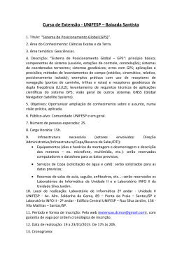
SAM/IG/3
WP/16
04/03/09
International Civil Aviation Organization
South American Regional Office
THIRD WORKSHOP/MEETING OF THE SAM IMPLEMENTATION GROUP (SAM/IG/3)
REGIONAL PROJECT RLA/06/901
Lima, Peru, 20-24 April 2009
Agenda Item 3:
Implementation of Performance-Based Navigation (PBN) in the
SAM Region
Activities carried out by the Brazilian Administration for PBN Implementation
(Presented by Brazil)
Summary
This working paper contains information about the activities carried out by the
Brazilian Administration for the implementation of PBN, including the Project for PBN
Implementation in TMAs (short term - until 2010), the timetable for the implementation
of Baro-VNAV RNP APCH procedures, RNAV/ILS, and (GNSS) RNAV departure
procedures. It also contains the GNSS and RNAV-5 AICs published on 09/04/2009, as
well as the preliminary analysis of the required changes to ATC automated systems.
References:
- SAM/IG/1 meeting report
- SAM/IG/2 meeting report
- GREPECAS/15 meeting report
1
Background
1.1
The SAM/IG/2 meeting took note that Project RLA/06/901 had developed a Model for
PBN Implementation in the TMA and Approach to ensure a better understanding of the expected
activities and results. The objective was to clearly define the deliverables, breaking down the large
volume of work in specific activities. These activities will serve as a basis for drafting the programme
timetable.
SAM/IG/3
WP/16
-2-
1.2
The SAM/IG/2 meeting also noted that the Model for PBN Implementation in the TMA
and Approach established new Action Plan model for the TMA and Approach. These plans were modified
to accommodate the results of the PBN Seminar (Lima, 17-20 June 2008) and the PBN Manual
(Doc. 9613). Changes made to the Action Plan models did not modify the essence of the previous action
plan. In this sense, the meeting formulated Conclusion SAM/IG/2-4, urging States to use the Model for
PBN Implementation in the TMA and Approach when drafting their PBN implementation programmes.
1.3
The GREPECAS/15 meeting noted that, with the approval of the CAR/SAM PBN Road
Map, PBN implementation planning in the CAR/SAM Regions was practically completed. The main
PBN task of GREPECAS would be the optimisation of ATS routes in the upper airspace and the
harmonisation of PBN implementation, taking into account the need to avoid multiple ATC procedures
and operational approval processes.
1.4
The GREPECAS/15 meeting, pursuant to Resolution 36/23 of the 36th ICAO Assembly,
and in order to provide guidance to the States/Territories/International Organisations, approved the
national implementation plan model for en-route, terminal control area (TMA), and approach, similar to
the one approved at the SAM/IG/2 meeting. In this sense, GREPECAS/15 approved Conclusion 15/38
urging CAR/SAM States and Territories to:
2
a)
Draft their national PBN implementation plan by December 2009, and submit it
to the corresponding Regional Office;
b)
Consider using the PBN action plan models developed by the GREPECAS PBN
Task Force; and
c)
Designate a point of contact to coordinate PBN implementation activities in each
State/Territory.
Discussion
2.1
Bearing in mind the guidance provided by GREPECAS and SAM/IG meetings, the
Brazilian Administration has initiated actions to implement PBN in the TMAs and Approach, as
described in the following paragraphs.
2.2
Implementation Projects in the Brasilia/Recife and Rio de Janeiro/São Paulo TMAs
2.2.1
The Brazilian Administration is developing the national PBN implementation plan
requested by GREPECAS in Conclusion 15/38. In the meantime, a PBN Implementation Project for the
Brasilia and Recife TMAs was developed, and is attached in Appendix A to this working paper. The
project was based on the action plan approved by the SAM/IG/2 meeting. The PBN implementation
project for the Rio and Sao Paulo TMAs is in the final phase of development, with a tentative
implementation date of November 2010.
2.2.2
The objective of the PBN implementation project for the Brasilia/Recife TMAs, in
addition to the implementation of PBN per se, is to gain experience in less complex, medium- to lowdensity airspaces, characterised by the Brasilia and Recife TMAs, respectively.
SAM/IG/3
WP/16
-3-
2.2.3
The Rio and Sao Paulo TMA implementation project is aimed at implementing PBN in
the two of the main TMAs of Brazil in terms of airspace density and complexity. Furthermore, the short
distance between the two TMAs (200 NM) and the inter-connection of air traffic flows between them,
made it necessary to develop the implementation project to ensure the harmonisation of airspace structure
and IFR procedures between the two TMAs.
2.3
Fast-time simulation of the Brasilia TMA
2.3.1
Fast-time simulation of the Brasilia and Recife TMAs started in December 2008, with a
view to comparing three basic scenarios:
a)
Current scenario (baseline) – to be used for comparison purposes;
b)
Scenario 1 – With SID/STAR procedures as direct as possible.
c)
Scenario 2 – With more direct SID/STAR procedures, also taking into account
the need to reduce airspace complexity.
2.3.2
Scenario 1 is aimed at increasing airspace efficiency through the use of SIDs/STARs as
direct as possible, linking the route structure directly to the initial approach points of RNP APCH
procedures. In this scenario, airspace structure is highly complex, taking into account the significant
number of crossings between arrival and departure paths. Airspace safety can be ensured through the
establishment of the appropriate altitudes at the departure and arrival crossing points. It is expected that
the implementation of the airspace concept associated to this scenario will be possible in low air traffic
density airspaces, such as the Recife TMA.
2.3.3
Scenario 2 is also aimed at increasing airspace efficiency through the use of SIDs/STARs
as direct as possible. However, the airspace concept in this case seeks to reduce airspace complexity,
with a view to increasing ATC capacity of the ATC unit involved. This scenario was developed based on
some experiences of the FAA, namely in the SIDs/STARs of the Atlanta airport. It is expected that the
airspace concept associated to this scenario will be feasible in medium- and high-density airspaces, such
as the Brasilia, Rio de Janeiro and São Paulo TMAs.
2.3.4
Some examples of SIDs and STARs associated to scenarios 2 and 3 of the Brasilia and
Recife TMAs are contained in Appendix B to this working paper.
2.4
Implementation of Baro/VNAV RNP APCH procedures, RNAV/ILS approach
procedures, and (GNSS) RNAV IFR departure procedures
2.4.1
Taking into account the benefits of early implementation of Baro/VNAV RNP APCH and
RNAV/ILS approach procedures, as well as (GNSS) RNAV IFR departure procedures, the Brazilian
Administration developed a project for the implementation of these procedures in 28 Brazilian airports in
a 2-year period. The first procedures shall be published in August 2009. At the end of the 2-year period
foreseen for full implementation, 256 IFR procedures will have been developed, of which 76 will be
Baro/VNAV RNP APCH IAC, 40 RNAV (GNSS)/ILS IAC, and 140 (GNSS) RNAV SIDs.
SAM/IG/3
WP/16
-4-
2.4.2
Some examples of Baro-VNAV RNP APCH procedures and (GNSS) RNAV IFR
departure procedures are contained in Appendix C to this working paper.
2.4.3
One of the difficulties encountered in the development of the new IFR procedures
involves the requirements of item 5.6.4 of Doc 8168 OPS/611 (PANS-OPS), concerning the visual
segment surface (VSS). Since 15 March 2007, the new procedures should be protected from obstacles in
the visual segment, defined by the VSS, or if they penetrate the VSS, an approach procedure should not
be issued without an aeronautical study. Procedures published prior to 15 March 2007 shall have VSS
protection following the periodical review, no later than 15 March 2012.
2.4.4
When developing BARO/VNAV RNP APCH procedures for the Vitoria and Belo
Horizonte airports, the procedure designers involved encountered obstacles penetrating the VSS. In the
case of the Vitoria airport, it will be possible to remove the obstacles, bearing in mind that they are
artificial obstacles related to public lighting. In the case of Belo Horizonte, natural obstacles (hills around
the airport) penetrate the VSS. The analyses made to date have shown that even if the descent slope/angle
is increased to the allowed limit, it will not be possible to implement approach procedures unless the
threshold is significantly displaced.
2.5
GNSS AIC
2.5.1
As foreseen in the Action Plans for En-route, TMA, and Approach Operations, the
Administration has assessed the regulations for GNSS implementation as a means of navigation and has
concluded that a complete reformulation is needed, based on the requirements established in the PBN
Manual for RNAV-5 (en-route), RNAV-1 (TMA), RNP APCH, and Baro-VNAV RNP APCH.
2.5.2
The new GNSS AIC, in its Portuguese and English versions, published on 09/04/2009, is
contained in Appendix D to this working paper.
2.6
RNAV-5 AIC
2.6.1
As foreseen in item 7.4 of the RNAV-5 Action Plan, the Brazilian Administration
published the RNAV-5 AIC on 09/04/2009, pursuant to Conclusion SAM/IG/2-2. This AIC, in its
Portuguese and English versions, appears in Appendix E.
2.7
Changes to ATC Automated Systems
2.7.1
Amendment No 1 to the 15th Edition of PANS-ATM (Doc 4444), effective 15 November
2012, involves significant changes in the insertion of alphanumeric codes related to RNAV and RNP
approvals, which are fundamental for PBN implementation. Considering current flight plan limitations,
most of these codes will be inserted in box 18.
2.7.2
The Brazilian Administration has begun studies concerning the changes required in ATC
automated systems that will result in the insertion of alphanumeric characters in flight progress strips and
in radar display targets, in keeping with information contained in Appendix F to this working paper. The
required changes have already considered in the new ATC system entitled “Sagitario”, to be implemented
starting in 2010.
SAM/IG/3
WP/16
-5-
3
Suggested Action
3.1
The Meeting is invited to:
a)
Take note of the information provided in the working paper.
b)
Consider the need to harmonise the presentation of the national PBN
implementation plans mentioned in GREPECAS Conclusion 15/38.
c)
Assess the use of the PBN points of contact foreseen in GREPECAS Conclusion
15/38 for the work at the SAM/IG meetings.
SAM/IG/3
WP/16
APPENDIX A
Project for PBN Implementation in the Brasilia and Recife TMAs
1 Airspace concept
Start
End
Responsible
party
15/12/08
31/03/09
States
1.1
etc.)
Establish and prioritise strategic objectives (safety, capacity, environment,
1.2
Collect traffic data in order to understand the traffic flows in TMA airspace
07/04/08
11/12/09
1.3
Analyse the navigation capacity of the aircraft fleet in the TMA
03/11/08
30/11/09
1.4
Analyse ground-based means of communication, navigation (VOR, DME), and
surveillance to meet navigation specifications and navigation reversal mode
15/12/08
31/07/09
1.5
Develop a new sectorisation of the Brasilia and Recife TMAs
17/03/09
30/04/09
1.6
Develop SIDs, STARs, and approach procedures based on strategic objectives
08/09/08
of the airspace concept
30/04/09
1.7
Conduct fast-time simulations
26/03/09
28/08/09
1.8
Conduct real-time simulations
26/03/09
28/08/09
2.
Develop a performance measuring plan
2.1
Draft a plan to measure performance, including gas emissions, safety,
efficienciy, etc.
30/03/09
05/06/09
2.2
Implement the performance measuring plan
01/03/10
01/03/11
3
Safety assessment
3.1
Determinar que metodología será usada para evaluar la seguridad en el espacio
aéreo y espaciamiento de rutas, dependiendo de la especificación de
02/03/09
navegación, considerando el “airspace modeling”, simulaciones ATC (tiempo
fast-time and/or in real-time), live tests, etc.
29/05/09
Develop a data collection programme to assess airspace safety
12/06/09
3.2
States
States
States
States
States
States
States
States
States
States
States
01/06/09
States
States
Remarks
SAM/IG/3
WP/16
A-2
3.3
Prepare the preliminary airspace safety assessment
3.4
Prepare the final airspace safety assessment
4
Establish a collaborative decision-making process (CDM)
4.1
Coordinate planning and implementation requirements with air navigation
service providers, regulators, users, aircraft operators, and military authorities
16/04/09
01/03/11
4.2
Assess the tentative implementation date
02/11/09
27/11/09
4.3
Define the documentation format at the DECEA PBN web site
26/05/08
20/06/08
4.4
Report planning and implementation progress to the corresponding Regional
20/04/09
Office
30/03/11
5
ATC automated systems
5.1
Assess PBN implementation in ATC automated systems, taking into account
09/02/09
amendment 1 to the PANS/ATM (FPLSG).
03/04/09
5.2
Implement the necessary changes in ATC automated systems
29/01/10
15/06/09
31/07/09
03/08/09
30/10/09
States
States
States
States
States
States
States
States
17/08/09
States
States
SAM/IG/3
WP/16
A-3
6
6.1
6.2
States
Aircraft and operator approval
Review aircraft and operator approval requirements (pilots, dispatchers, and
maintenance personnel), as defined in the PBN Manual, and develop the 08/10/08
necessary documentation.
Publish national regulations for the implementation of the RNAV-1 navigation
01/05/09
specification
6.3
Begin the approval of aircraft and operators
6.4
Establish and keep up to date a registry of approved aircraft and operators
States
30/04/09
19/06/09
22/06/09
01/03/10
22/06/09
01/03/10
6.5
Verify the operation of the continuous monitoring programme (aircraft and
01/03/10
procedures)
01/03/11
7
Standards and procedures
7.1
Assess and, if appropriate, publish the regulations on the use of GNSS
07/04/08
09/04/09
7.2
Finalise WGS-84 implementation
03/08/09
14/08/09
7.3
Ground validation and in-flight inspection of SIDs and/or STARs
05/10/09
06/11/09
7.4
Establish the navigation database validation requirements and procedures
16/06/09
30/10/09
7.5
Develop an AIC model to report PBN implementation plans
27/04/09
05/06/09
7.6
Publish the AIC reporting on PBN implementation plans
08/06/09
10/08/09
7.7
Develop the AIP Supplement model containing applicable standards and
procedures, including the corresponding in-flight contingencies
Publish the AIP Supplement containing applicable standards and procedures,
including the corresponding in-flight contingencies
17/08/09
16/10/09
15/01/09
15/01/09
19/10/09
18/12/09
19/10/09
18/12/09
7.8
7.9
Review the Procedural Handbook of the ATS units involved
7.10 Update the letters of agreement between ATS units
States
States
States
States
States
States
States
States
States
States
States
States
States
States
States
SAM/IG/3
WP/16
A-4
States
8
Training
8.1
Develop a training programme and documentation for operators (pilots,
dispatchers an maintenance personnel)
01/06/09
28/08/09
8.2
Develop a training programme and documentation for air traffic controllers and
19/10/09
AIS operators
18/12/09
8.3
Develop a training programme for regulators (aviation safety inspectors)
19/10/09
18/12/09
8.4
Conduct training programmes
31/08/09
26/03/10
8.5
Conduct seminars for operators, explaining plans and expected operational and
economic benefits
01/09/09
12/03/10
9
Implementation decision
9.1
Assess the available operational documentation (ATS, OPS/AIR)
26/01/09
30/01/09
9.2
Assess the percentage of approved aircraft and operators (non-exclusionary
airspace)
26/01/09
30/01/09
9.3
Analyse safety assessment results
26/01/09
30/01/09
9.4
Publish trigger NOTAM
20/03/09
23/03/09
10
Performance monitoring system
States
States
States
States
States
States
States
States
States
States
10.1 Develop a post-implementation monitoring programme for TMA operations
02/11/09
26/03/10
10.2 Implement a post-implementation monitoring programme for TMA operations
26/03/10
31/03/11
Pre-operational implementation date
Definitive implementation date
States
08/04/10
08/04/11
States
States
States
States
SAM/IG/3
NE-WP/16
- B1 -
APÉNDICE B / APPENDIX B
Simulación en Tiempo Acelerado TMA Brasilia
Escenario 2
Simulation in Accelerated time Brasilia TMA
Scenario 2
STAR
SAM/IG/3
NE-WP/16
- B2 -
SAM/IG/3
NE-WP/16
- B3 -
SAM/IG/3
NE-WP/16
- B4 -
SAM/IG/3
NE-WP/16
- B5 -
SAM/IG/3
NE-WP/16
- B6 -
SAM/IG/3
NE-WP/16
- B7 -
SAM/IG/3
NE-WP/16
- B8 -
SAM/IG/3
NE-WP/16
- B9 -
Simulación en Tiempo Acelerado TMA Brasilia
Escenario 3
Simulation in Accelerated time Brasilia TMA
Scenario 3
VISIÓN GENERAL / GENERAL SCOPE
SAM/IG/3
NE-WP/16
- B10 -
Simulación en Tiempo Acelerado TMA Brasilia
Escenario 3
Simulation in Accelerated time Brasilia TMA
Scenario 3
STAR
SAM/IG/3
NE-WP/16
- B11 -
SAM/IG/3
NE-WP/16
- B12 -
SAM/IG/3
NE-WP/16
- B13 -
SAM/IG/3
NE-WP/16
- B14 -
Simulación en Tiempo Acelerado TMA Brasilia
Escenario 3
Simulation in Accelerated time Brasilia TMA
Scenario 3
SID
SAM/IG/3
NE-WP/16
- B15 -
SAM/IG/3
NE-WP/16
- B16 -
SAM/IG/3
NE-WP/16
- B17 -
Simulación en Tiempo Acelerado TMA Recife
Escenario 2
Simulation in Accelerated time Recife TMA
Scenario 2
SAM/IG/3
NE-WP/16
- B18 -
SAM/IG/3
NE-WP/16
- B19 -
Simulación en Tiempo Acelerado TMA Recife
Escenario 3
Simulation in Accelerated time Recife TMA
Scenario 3
SAM/IG/3
NE-WP/16
- C1 -
APÉNDICE C / APPENDIX C
Ejemplos de Procedimientos RNP APCH con Baro-VNAV y Salidas RNAV (GNSS)
Examples of RNP APCH Procedures with Baro-VNAV and RNAV Exits (GNSS)
RNP APCH con Baro-VNAV
SAM/IG/3
NE-WP/16
- C2 -
SAM/IG/3
NE-WP/16
- C3 -
Procedimientos de Salida IFR RNAV (GNSS)
IFR RNAV Exit Procedures (GNSS)
SAM/IG/3
NE-WP/16
- C4 -
SAM/IG/3
NE-WP/16
- C5 -
Procedimientos de Aproximación RNAV (GNSS) – ILS
RNAV APP Procedures (GNSS) - ILS
SAM/IG/3
NE-WP/16
APÉNDICE E / APPENDIX D
BRASIL
DEPARTAMENTO DE CONTROLE DO ESPAÇO AÉREO
AIC
A
DIVISÃO DE GERENCIAMENTO DE NAVEGAÇÃO AÉREA
08/09
AV GENERAL JUSTO, 160 – 2º AND. - CASTELO
20021-130-RIO DE JANEIRO – RJ
TEL: 021 3814-8237
AFTN: SBRJYNYI
ADM: PAME FAX: 021 2101-6252
09 ABR 2009
TELEX: 2137113 COMAER BR
SISTEMA GLOBAL DE NAVEGAÇÃO POR SATÉLITES - GNSS
1
DISPOSIÇÕES PRELIMINARES
1.1 FINALIDADE
A presente Circular de Informações Aeronáuticas - AIC tem por finalidade
estabelecer os critérios para utilização do Sistema Global de Navegação por Satélites – GNSS
no espaço aéreo brasileiro.
1.2 ÂMBITO
As disposições estabelecidas nesta AIC aplicam-se a todos aqueles que, no
decorrer de suas atividades, venham a utilizar o GNSS como meio de navegação aérea primário.
2
DISPOSIÇÕES GERAIS
2.1 A 10ª Conferência de Navegação Aérea, da Organização de Aviação Civil Internacional OACI, realizada em 1991, endossou a concepção do sistema de Comunicações, Navegação,
Vigilância/Gerência de Tráfego Aéreo - CNS/ATM, buscando o emprego de novas
tecnologias disponíveis, de forma a propiciar um melhor gerenciamento do tráfego aéreo.
2.2 Com as primeiras iniciativas de implantação de sistemas CNS/ATM por alguns Estados e
Grupos Regionais de Planejamento e Implementação (PIRG), observou-se à necessidade de se
desenvolver um conceito completo, buscando um sistema ATM global integrado, atendendo a
requisitos operacionais claramente estabelecidos. Este conceito formaria a base para a
implantação coordenada das tecnologias CNS/ATM.
2.3 Em resposta às necessidades supracitadas, a Organização de Aviação Civil Internacional
(OACI) elaborou o Conceito Operacional ATM Global, que foi aprovado pela 11ª
Conferência de Navegação Aérea, e publicado como o Doc. 9854 AN/458.
BRASIL
DEPARTAMENTO DE CONTROLE DO ESPAÇO AÉREO
AIC
A
DIVISÃO DE GERENCIAMENTO DE NAVEGAÇÃO AÉREA
08/09
AV GENERAL JUSTO, 160 – 2º AND. - CASTELO
20021-130-RIO DE JANEIRO – RJ
TEL: 021 3814-8237
AFTN: SBRJYNYI
ADM: PAME FAX: 021 2101-6252
09 ABR 2009
TELEX: 2137113 COMAER BR
GLOBAL NAVIGATION SATELLITE SYSTEM – GNSS
1
PRELIMINARY GUIDELINES
1.1 PURPOSE
This Aeronautical Information Circular (AIC) has the purpose of establishing the criteria for
use of the Global Navigation Satellite System (GNSS) within the Brazilian airspace.
1.2 SCOPE
The procedures established by this AIC are applied to all those who use the GNSS as the
primary means of navigation.
2
GENERAL GUIDELINES
2.1
The 10th Air Navigation Conference of the International Civil Aviation Organization –
ICAO, held on 1991, endorsed the concept of Communications, Navigation, Surveillance /
Air Traffic Management System – CNS/ATM, considering the use of the new available
technologies in order to achieve a better air traffic management.
2.2
After further development work of the implementation of the CNS / ATM system by
some States and Planning and Implementation Regional Groups (PIRG), it was observed the
need of a complete concept, moving towards an integrated global ATM system, in order to
establish clear operational requirements. Such concept would be the basis for the coordinated
implementation of the CNS / ATM technologies.
2.3
After analyzing the needs proposed, the International Civil Aviation Organization
(ICAO) has developed the Global ATM Operational Concept, Doc. 9854 AN/458, approved
by the 11th Air Navigation Conference.
09 ABR 2009
AIC A08/09
2.4 Em um esforço para ajudar aos Estados com a implantação do Conceito Operacional
ATM Global, a OACI publicou o novo Plano Global de Navegação Aérea. Este plano
concentra-se na perspectiva de oferecer melhorias técnicas e operacionais que permitirão aos
exploradores de aeronaves obter benefícios em curto e médio prazo.
2.5 O planejamento global se concentra em objetivos de performance específicos, apoiados
por um conjunto de “Iniciativas do Plano Global” (GPI). O GNSS é uma ferramenta essencial
para a implementação de uma série de GPI, tais como: Navegação Baseada em Performance
(PBN) e Aplicações de enlaces de dados.
2.6 Desta forma, o emprego do GNSS previsto nesta AIC proporcionará a transição
necessária para a aplicação das GPI envolvidas, por meio da antecipação de alguns elementos
da Navegação Baseada em Performance (PBN).
3
CONCEITUAÇÃO
3.1 CONTINUIDADE
Capacidade do sistema em proporcionar informações válidas de navegação
para a operação pretendida, sem a ocorrência de interrupções não programadas.
3.2 DISPONIBILIDADE
A disponibilidade de um sistema de navegação é o percentual de tempo em que
são utilizáveis as informações providas por este sistema. É uma indicação da capacidade do
sistema em proporcionar informações utilizáveis dentro de uma determinada zona de
cobertura, bem como do percentual de tempo em que se transmitem sinais de navegação, a
partir de fontes externas. A disponibilidade é função das características físicas do entorno e da
capacidade técnica das instalações dos transmissores.
3.3 EQUIPAMENTOS BÁSICOS DE NAVEGAÇÃO AÉREA
Equipamentos previstos e nas quantidades estabelecidas no Regulamento
Brasileiro de Homologação Aeronáutica (RBHA).
3.4 EQUIPAMENTOS SUPLEMENTARES DE NAVEGAÇÃO AÉREA
Equipamentos que devem ser utilizados em conjunto com um equipamento
básico de navegação aérea. A aprovação dos equipamentos suplementares para determinada
fase de voo exige que se transporte a bordo um equipamento básico de navegação aérea para a
referida fase. Quanto à performance, um equipamento suplementar de navegação aérea deve
satisfazer aos requisitos de precisão e de integridade para tal operação ou fase de voo, não
sendo necessário satisfazer aos requisitos de disponibilidade e de continuidade.
3
AIC A08/09
09 ABR 2009
2.4 In an effort to facilitate implementation of the Global ATM Operational Concept, ICAO
has published a new Global Air Navigation Plan. The revised Plan was developed to ensure
that near and medium term benefits would be realized through a focused effort.
2.5 In accordance with the Global Plan, planning will be focused on specific performance
objectives, supported by a set of “Global Plan Initiatives” (GPI). The GNSS serves as an
essential tool for the implementation of a series of GPI, such as: Performance-Based
Navigation (PBN) and Data Link Applications.
2.6 Therefore, the use of GNSS prescribed by this AIC will bring the needed transition for
the implementation of the involved GPI, by introducing some elements of the PerformanceBased Navigation (PBN).
3
CONCEPTIONS
3.1
CONTINUITY
The capability of the system to perform its function without unscheduled
interruptions, during the intended operation.
3.2
AVAILABILITY
The availability of a navigation system is the percentage of time that the
information provided by the system is usable. It is an indication of the capacity of the system
to provide usable information within the specified coverage zone, as well as the percentage of
time that navigation signals transmitted, from external sources, are available to use. The
availability is a function of both physical characteristics of the environment and the technical
capabilities of the transmitters’ installation.
3.3
BASIC EQUIPMENT OF AIR NAVIGATION
Equipment whose type and amounts are established in the Brazilian Rules of
Aeronautical Homologation.
3.4
SUPPLEMENTAL EQUIPMENTS OF AIR NAVIGATION
Equipments that shall be used together with a basic equipment of air
navigation. The approval of the supplemental equipment for a certain flight phase demands
that a basic equipment of air navigation is transported on board for the referred flight phase.
Concerning the performance, a supplemental equipment of air navigation shall satisfy the
accuracy and integrity requirements for such operation or flight phase, not being necessary to
satisfy the availability and continuity requirements.
4
09 ABR 2009
AIC A08/09
3.5 INTEGRIDADE
Garantia de que todas as funções do sistema de navegação estão dentro dos
limites de performance operacional. É a capacidade do sistema de navegação aérea de
proporcionar aos usuários avisos oportunos nos casos em que o mesmo não deva ser utilizado.
3.6 MONITORAMENTO
RECEPTOR (RAIM)
AUTÔNOMO
DE
INTEGRIDADE
ASSOCIADO
AO
Técnica através da qual um receptor GNSS determina a integridade dos sinais
de navegação sem se referenciar a sensores ou a sistemas de integridade externos ao próprio
receptor.
3.7 NAVEGAÇÃO DE ÁREA (RNAV)
É um método de navegação que permite a operação de aeronave em qualquer
trajetória desejada dentro da cobertura de auxílios à navegação aérea ou dentro dos limites de
capacidade de sistemas autônomos ou a combinação destes.
3.8 NAVEGAÇÃO EM ÁREA TERMINAL
Fase da navegação em que as aeronaves seguem rotas especificadas de saída ou
chegada (SID ou STAR) ou qualquer outra operação entre o último fixo em rota e o fixo de
aproximação inicial (IAF).
3.9 NAVEGAÇÃO VERTICAL BAROALTIMÉTRICA (Baro-VNAV).
É um sistema de navegação que apresenta ao piloto um guia vertical calculado
com referência a um ângulo de trajetória vertical especificada (VPA), nominalmente de 3º. O
guia vertical calculado pelo computador é baseado na altitude baroaltimétrica e especifica um
ângulo de trajetória vertical desde a altura do ponto de referência (RDH) para procedimentos
de aproximação com guia vertical (APV).
3.10PRECISÃO
É o grau de conformidade entre a informação sobre posição e hora que
proporciona o sistema de navegação e a posição e hora verdadeiras.
3.11 PROCEDIMENTO DE APROXIMAÇÃO COM GUIA VERTICAL (APV)
Procedimento de Aproximação por instrumentos que utiliza guia lateral e
vertical, porém não satisfazendo os requisitos estabelecidos para as operações de aproximação
de precisão.
5
AIC A08/09
09 ABR 2009
3.5 INTEGRITY
The assurance that all the functions of the navigation system are within
operational performance limits. It is the capacity of the air navigation system to provide the
users with opportune warnings in case it shall not be used.
3.6 RECEIVER AUTONOMOUS INTEGRITY MONITORING (RAIM)
Technique whereby an airborne GNSS receiver determines the integrity of the
navigation signals without referring to other sensors or to other integrity systems external to
the receiver.
3.7 AREA NAVIGATION (RNAV)
A method of navigation which permits aircraft operation on any desired flight
path within the coverage of station-referenced navigation aids or within the limits of the
capability of self-contained aids, or a combination of these.
3.8 NAVIGATION IN THE TERMINAL AREA
Phase of navigation when the aircraft follow specific routes for departure or
arrival (SID or STAR), or any other operation between the last fix en route and the initial
approach fix (IAF).
3.9 BAROMETRIC VERTICAL NAVIGATION (Baro-VNAV)
It is a navigation system which presents computed vertical guidance to the pilot
referenced to a specific Vertical Path Angle (VPA), nominally three degrees. The onboard
avionics computer resolves vertical guidance data based on barometric altitude and it is
specified as vertical guidance angle from the Reference Datum Height (RDH) to the approach
procedures with vertical guidance (APV).
3.10 ACCURACY
The degree of conformance between the position and time information
provided by the navigation system and the true position and time.
3.11 APPROACH PROCEDURE WITH VERTICAL GUIDANCE (APV)
An approach with vertical guidance is an instrument approach procedure which
utilizes lateral and vertical guidance, but which does not meet all the performance
requirements needed for precision approach and landing operations.
6
09 ABR 2009
AIC A08/09
3.12 ROTA RNAV
É uma rota ATS estabelecida para aeronaves capazes de empregar navegação
de área.
4
SISTEMA GLOBAL DE NAVEGAÇÃO POR SATÉLITES (GNSS)
4.1 A constelação satelital atualmente disponível para uso operacional é o “Global
Positioning System (GPS)” provido pelos Estados Unidos da América, entretanto, outros
sistemas estão em desenvolvimento e atenderão aos Padrões e Normas Recomendados
(SARPS), da OACI. Os sinais do GPS necessitam ser melhorados de forma a atender os
requisitos operacionais para as diversas fases do voo.
4.2 A navegação GNSS é baseada em um contínuo conhecimento da posição espacial de cada
satélite e proporciona precisão horizontal da ordem de 20 metros, com 95% de probabilidade
(95 % do tempo) e 300 metros com 99,99% de probabilidade, sem a utilização de técnicas
destinadas a melhorar a performance do sistema.
4.3 No entanto, a constelação básica GPS não provê avisos com antecedência suficiente,
quando um satélite transmite uma informação inválida. Por esta razão, os aviônicos utilizados
para navegação IFR devem melhorar o sinal Básico GPS para, além de outros fatores,
assegurar sua integridade.
4.4 O termo “Aircraft Based Augmentation System (ABAS)” inclui uma melhoria e/ou
integração do GNSS com as informações disponíveis a bordo da aeronave, de forma a
melhorar a performance dos sistemas satelitais.
4.5 A técnica ABAS mais comum é chamada “Receiver Autonomous Integrity Monitoring
System (RAIM)”. O RAIM usa medidas satelitais redundantes para detectar sinais errôneos e
alertar aos pilotos.
4.6 Um receptor GNSS que se apóie unicamente na função RAIM necessita de um mínimo
de 5 (cinco) satélites em linha de visada, tornando necessário que o piloto efetue verificações
de disponibilidade da função RAIM, antes de ingressar nas fases de navegação pretendidas
(rota, chegada, saída, e/ou aproximação).
7
AIC A08/09
09 ABR 2009
3.12 RNAV ROUTE
It is an ATS route established for aircraft capable of using area navigation.
4. GLOBAL NAVIGATION SATELLITE SYSTEM (GNSS)
4.1 The satellite navigation systems available for operational use is the Global Positioning
System (GPS) of the United States. However other systems are being introduced and they will
answer the ICAO Standard and Recommended Procedures. The GPS signals must be
improved in order to support the operational requirements for the various phases of flight.
4.2 The GNSS navigation is based on a continuous acknowledge of the spatial position of
each satellite and provides horizontal accuracy of around 20 meters, with 95% of probability
(95% of time) and 300 meters with 99,99% probability, without using the techniques destined
to improve the performance of the system.
4.3 However the basic constellation of GPS does not provides warnings with priority enough,
when the satellite provides invalid information. For this reason, the avionics used for the IFR
navigation must improve the GPS Basic signal to also guarantee their integrity.
4.4 The term Aircraft Based Augmentation System (ABAS) includes a development and/or an
integration of the GNSS with the information available onboard, in order to improve the
performance of the satellite systems.
4.5 The most common ABAS technique is known as Receiver Autonomous Integrity
Monitoring System (RAIM). The RAIM uses redundant additional satellite measures to check
any incorrect signals and to warn the pilots.
4.6 A GNSS receiver that performs only the RAIM function requires at least 5 (five) satellites
in sight, as the pilot should check the appropriate RAIM function availability before entering
the desired phases of navigation (route, arrival, departure and/or approach).
8
09 ABR 2009
5
AIC A08/09
CRITÉRIOS DE UTILIZAÇÃO DO GNSS
5.1 CRITÉRIOS GERAIS
5.1.1
Os procedimentos de navegação aérea previstos nesta AIC (Rota, Chegada, Saída e
Aproximação) somente deverão ser executados por operadores e aeronaves aprovados pelo
Estado de Registro ou Estado do Operador, conforme o caso. O processo de aprovação de
operadores e aeronaves brasileiras é estabelecido pela Agência Nacional de Aviação Civil.
5.1.2
Tipicamente os receptores GNSS devem atender, pelo menos, aos requisitos
estabelecidos no Anexo 10, volume I, e no Doc. 9613 (Manual PBN), ambos da Organização
de Aviação Civil Internacional, observando as classes de equipamentos necessárias para a
operação em cada fase do voo. No entanto, o processo de aprovação de aeronaves e
operadores, mencionado em 5.1.1, determinará as exigências quanto aos receptores GNSS.
5.1.3
O receptor GNSS Básico verifica a integridade dos sinais recebidos da constelação de
satélites, através de um monitor autônomo de integridade (RAIM), de forma a determinar se
os satélites estão fornecendo uma informação confiável. Alarmes de RAIM podem ocorrer
devido a um número insuficiente de satélites ou devido a uma geometria inadequada dos
satélites, que podem fazer com que o nível de confiança na solução de posição seja inferior ao
aceitável. A posição da antena na aeronave, a posição dos satélites em relação ao horizonte e a
atitude da aeronave podem afetar a recepção do sinal de um ou mais satélites. Considerando o
fato de que a posição relativa dos satélites está em constante mudança, a disponibilidade de
RAIM deverá sempre ser avaliada. Se o RAIM não estiver disponível, outro tipo de
navegação deve ser usado ou o horário do voo modificado até que o RAIM esteja disponível.
Em voos longos, os pilotos devem considerar a avaliação periódica do RAIM durante o voo.
Isto pode prover indicações antecipadas de uma falha não programada de um satélite a partir
da decolagem.
5.1.4 As coordenadas geográficas utilizadas nos procedimentos de navegação aérea
baseados em GNSS e nas cartas publicadas pelo DECEA têm como referência o Sistema
Geodésico Mundial (WGS-84).
5.1.5 Deverá ser feita a previsão de disponibilidade da função RAIM antes da decolagem e
do ingresso em cada uma das fases do voo.
9
AIC A08/09
5
09 ABR 2009
CRITERIA FOR THE USE OF GNSS
5.1 GENERAL CRITERIA
5.1.1 The procedures for the air navigation included in this AIC (Route, Arrival, Departure
and Approach) must be accomplished only by the operators and the aircraft approved by the
State of the Register or the State of the Operator, according to the situation. The process for
the approval of the Brazilian operators and aircraft are established by the Civil Aviation
National Agency (ANAC).
5.1.2 Usually, the GNSS receivers must attend, at least, the requirements established in the
Annex 10, volume I, and in the Doc. 9613 (PBN Manual) , observing the classes of
equipments needed for the operation in each phase of flight. However, the process for aircraft
and operator approval, mentioned above in 5.1.1, will determine the requirements for the
GNSS receivers.
5.1.3 The Basic GNSS receiver verifies the integrity of the signals received by the
constellation of satellites through a Receiver Autonomous Integrity Monitoring System
(RAIM), in order to determine if the satellites are furnishing trustful information. RAIM
alarms may occur due to a small number of satellites or due to inadequate geometry of the
satellites that may turn the trust level in the position solution lower than the acceptable. The
position of the aircraft antenna, the position of the satellites in relation to the horizons and the
attitude of the aircraft may affect the reception of the signal of one or more satellites.
Considering the fact that the relative position of the satellites is always changing, the
availability of the RAIM must always be evaluated. When the RAIM is not available, other
type of navigation must be used or the schedule of the flight must be changed until the RAIM
is available again. During long flights, the pilots must consider the periodic evaluation of the
RAIM during the flight. This may furnish indications of a non predictable failure from a
satellite since the departure.
5.1.4 The geographical coordinates used in the air navigation procedures based on GNSS and
on the charts published by DECEA have as reference the World Geodetic System (WGS-84).
5.1.5 A prediction of the availability of the RAIM function must be made before the departure
and the entrance to each phase of flight.
10
09 ABR 2009
5.1.6
AIC A08/09
As informações de altitude utilizadas deverão ser fornecidas pelo altímetro
barométrico da aeronave.
5.1.7
Quando houver discrepância significativa entre as informações do receptor GNSS e
dos auxílios à navegação aérea instalados no solo, os pilotos deverão utilizar as informações
provenientes destes últimos.
5.1.8
Os operadores de aeronaves não devem solicitar ou inserir no plano de voo
procedimentos de navegação aérea baseados em GNSS, caso não tenham recebido a
correspondente aprovação operacional e da aeronave pela autoridade competente, conforme
previsto em 5.1.1. Neste caso, se uma aeronave receber uma autorização do órgão ATS para
executar um procedimento GNSS, o piloto deverá informar a incapacidade de atender a
autorização e requerer uma nova autorização.
5.1.9
É recomendável a aplicação de diretor de voo ou piloto automático, no modo de
navegação lateral, quando disponível, nas operações em rota, terminal (SID e STAR) e
Procedimentos de Aproximação IFR.
5.1.10 Os órgãos ATS não estão aptos a fornecer qualquer informação sobre a integridade
operacional do sistema. Isto é particularmente importante quando a aeronave for autorizada a
iniciar uma aproximação. Procedimentos devem ser estabelecidos para os casos em que forem
previstas falhas na navegação GNSS. Nestas situações os pilotos devem reverter para um
método alternativo de navegação.
5.1.11 BASE DE DADOS DE NAVEGAÇÃO
5.1.11.1 Os operadores deverão assegurar-se que a base de dados utilizada para navegação
esteja atualizada de acordo com o ciclo AIRAC correspondente. A base de dados de
navegação deve estar atualizada para a duração do voo. Em caso de ocorrência de mudança do
ciclo AIRAC durante o voo, operadores e pilotos devem estabelecer procedimentos para
assegurar a precisão dos dados de navegação, incluindo os auxílios requeridos para definir
rotas e procedimentos.
5.1.11.2 Para assegurar a correção da base de dados, os pilotos devem verificar os dados
apresentados no “display” do equipamento, após o carregamento do mesmo no plano de voo
ativo, antes de voar o procedimento, a fim de garantir a correção e a coerência da rota
autorizada pelo ATC e as eventuais modificações subsequentes, assim como sua coerência
com as cartas publicadas pelo DECEA. Caso não haja conformidade, as informações da base
de dados não poderão ser utilizadas. Alguns receptores possuem um “moving map display”
que ajuda o piloto na condução das citadas verificações.
11
AIC A08/09
09 ABR 2009
5.1.6 The information on the altitude used must be supplied by the barometric altimeter of the
aircraft.
5.1.7 When there is a significant discrepancy between the information from the GNSS
receiver and the air navigation aids installed on the ground, the pilots must use the
information provided by such aids.
5.1.8 The aircraft operators should not request or include in the flight plan the air navigation
procedures based on GNSS, when they do not receive the corresponding operational and
aircraft approval by the competent authority, according to the prescribed in the item 5.1.1. In
such case, if an aircraft receives a clearance from the ATS unit to accomplish a GNSS
procedure, the pilot must inform that he/she can not accomplish the authorization and request
another one.
5.1.9 It’s recommendable, when available, the use of a flight director or autopilot in lateral
navigation mode in en route, terminal (SID and STAR) Operations and IFR Approach
Procedures.
5.1.10 The ATS units are not capable to furnish any information on the operational integrity
of the system. This is especially important when the aircraft is authorized to begin an
approach. Procedures must be established for the instances when failures on the GNSS are
foreseen. In such situations the pilots must reverse to an alternative navigation method.
5.1.11 NAVIGATION DATABASE
5.1.11.1 The operators must assure that the database used for the navigation is updated with
the corresponding AIRAC cycle. The navigation database must be updated for the flight
duration. If there is any change to the AIRAC cycle during the flight, the operators and pilots
must establish procedures to assure the accuracy of the navigation data, including the air
navigation aids required to define the routes and procedures.
5.1.11.2 To assure the correctness of the data base, the pilots must check the data showed on
the display of the equipment, after stored on the active flight plan, before flying the
procedure, in order to guarantee the correctness and the coherency of the route authorized by
the ATC and any occasional subsequent changes, as well as its coherency with the charts
published by DECEA. If there is any discrepancy, information on the data base shall not be
used. Some receivers have a moving map display that helps the pilot to check such
information.
12
09 ABR 2009
AIC A08/09
5.1.11.3 A Base de Dados de Navegação deve ser obtida de um provedor que atenda aos
requisitos estabelecidos nos documentos RTCA DO-200A/EUROCAE ED 76, “Standards for
Processing Aeronautical Data”, conforme previsto no Doc. 9613 (Manual PBN).
5.1.11.4 Discrepâncias que invalidem um procedimento devem ser reportados ao provedor de
base de dados de navegação e os procedimentos não devem ser utilizados pelos tripulantes de
voo.
5.1.11.5 Os operadores de aeronaves devem conduzir verificações periódicas na base de
dados de navegação, a fim de atender aos requisitos de garantia de qualidade do sistema.
5.1.12 PRÉ-VOO
5.1.12.1
Todas as operações IFR com um receptor GNSS devem ser conduzidas de acordo
com o manual de operações da aeronave. Antes de um voo IFR empregando o receptor
GNSS, o operador deverá assegurar-se de que a operação, o equipamento e a instalação
estejam aprovados e certificados pela autoridade competente para a operação IFR pretendida.
5.1.12.2
O piloto/operador deverá seguir os procedimentos específicos de inicialização e
autoteste para o receptor GNSS como descrito no manual de operações da aeronave.
5.1.12.3
O piloto deverá conhecer, dentre outros aspectos constantes do processo de
aprovação operacional, mencionado em 5.1.1:
a) Operação e limitações do receptor GNSS instalado em sua aeronave,
incluindo criação, ativação/alteração de rotas, seleção e ativação de
procedimentos de subida e de descida;
b) Procedimentos para verificação da disponibilidade da função RAIM; e
c) Seleção dos modos de navegação em Rota, em Terminal e em
Aproximação.
5.2 CRITÉRIOS ESPECÍFICOS
5.2.1 VOO EM ROTA
5.2.1.1 As aeronaves voando sob regras de voo por instrumentos deverão possuir os
equipamentos básicos de navegação aérea (ver item 3.3) apropriados para a rota a ser voada,
os quais deverão obrigatoriamente ser utilizados, caso haja alarme de integridade e nos
trechos da rota em que haja previsão de indisponibilidade da função RAIM.
13
AIC A08/09
09 ABR 2009
5.1.11.3 The Navigation Data Base must be obtained through a provider that complies with
the requirements established by the documents RTCA DO-200A/EUROCAE ED 76
“Standards for Processing Aeronautical Data”, as foreseen in Doc. 9613 (PBN Manual).
5.1.11.4 Discrepancies that invalidate a procedure must be reported to the navigation database
supplier and affected procedures shall not be used by flight crew.
5.1.11.5 Aircraft operators should consider the need to conduct their own database checks in
order to comply with the requirements for the quality assurance of the system.
5.1.12 PREFLIGHT
5.1.12.1 All the IFR operations with a GNSS receiver must be conducted according to the
aircraft operations manual. Before flying IFR, using a GNSS receiver, the operator must be
sure that the operation, the equipment and the installation are approved and certified by the
competent authority for the intended IFR operation.
5.1.12.2 The pilot/operator must follow the specific procedures at the beginning of
initialization and auto-test of the GNSS receiver as described on the aircraft operations
manual.
5.1.12.3 The pilot must know, among others aspects included in the operational approval
process, mentioned on 5.1.1:
a) Operation and limitation of the GNSS receiver installed in the aircraft, including
the route creation and route activation/deactivation, as well as selection and
activation of departure and approach procedures.
b) Procedures to check the availability of RAIM function;
c) Selection of navigation modes: en Route, Terminal and Approach.
5.2 SPECIFIC CRITERIA
5.2.1 EN ROUTE FLIGHT
5.2.1.1 Aircraft flying under instrument flight rules shall have the basic equipment for air
navigation (see item 3.3) appropriate for the route to be flown. Such equipment shall be used
compulsorily, when there is an integrity alarm and on the portion of the route where the
function RAIM is supposed to be unavailable.
14
09 ABR 2009
5.2.2
AIC A08/09
CHEGADA PADRÃO POR INSTRUMENTOS (STAR) E SAÍDA PADRÃO POR
INSTRUMENTOS (SID)
5.2.2.1
Os equipamentos das aeronaves deverão ser aprovados de acordo com a classe de
equipamento prevista para execução de SID ou STAR GNSS.
5.2.2.2 As aeronaves executando SID GNSS ou STAR GNSS deverão estar com seus
equipamentos básicos de navegação sintonizados nas frequências adequadas, de forma a
proporcionar transição rápida e segura no caso de ocorrência de alarme de RAIM. Caso haja
previsão de indisponibilidade da função RAIM durante o período de voo, somente deverão ser
utilizados os equipamentos básicos de navegação aérea.
5.2.2.3 A STAR e a SID GNSS só poderão ser utilizadas caso sejam extraídas de uma base de
dados, por meio da inserção do designador do procedimento, que:
a) Contenha todos os “way-points” descritos na carta que descreve o procedimento de
aproximação a ser voado; e
b) Apresente os “way-points” na mesma sequência em que estão publicadas na carta
que descreve o procedimento.
5.2.2.4 A sequência de “way-points” estabelecida nas STAR e SID pode ser modificada pelo
piloto, como resultado de autorizações ATC, por meio da inserção (a partir da base de dados)
e da exclusão de “way-points”.
5.2.2.5 Na execução de SID e STAR RNAV não é permitida:
a) A criação manual de novos “way-points”, não previstos na base de dados, por meio
da inserção de coordenadas geográficas ou quaisquer outros meios.
b) A modificação do tipo de “way-point”, de “fly-over” para “fly-by” e vice-versa.
5.2.2.6 Caso a aeronave seja retirada de sua rota pré-estabelecida, em consequência de uma
vetoração radar, o piloto não deve modificar o plano de voo inserido no sistema, até que uma
nova autorização seja emitida pelo controlador de tráfego aéreo, a fim de que seja possível
voltar à rota inicial, em um ponto especificado pelo órgão ATC ou empregar uma nova rota
autorizada.
15
AIC A08/09
5.2.2
09 ABR 2009
STANDARD TERMINAL ARRIVAL ROUTES (STAR) AND STANDARD
INSTRUMENT DEPARTURE (SID)
5.2.2.1 The equipments of the aircraft must be approved according to the class of the
equipment prescribed for the execution of the SID or STAR GNSS.
5.2.2.2 Aircraft accomplishing GNSS SID or GNSS STAR must have their basic navigation
equipment tuned on the appropriate frequencies, so as to provide fast and safe transition in the
case of occurrence of RAIM alarm. In case that there is prevision of unavailability of the
RAIM function during the flight period, only the basic equipment of air navigation shall be
used.
5.2.2.3 GNSS STAR and GNSS SID may be used only when extracted from a data base, by
inserting the procedure designator, that;
a) Include all waypoints described by the chart that describes the approach procedure
to be flown; and
b) Show the waypoints on the same sequence as they are published by the chart that
describes the procedure.
5.2.2.4 The sequence of waypoints established by the STAR and SID may be changed by the
pilot, as a result of the ATC clearances, by the inclusion (from the database) and exclusion of
the waypoints.
5.2.2.5 The following is not allowed when accomplishing the SID and STAR RNAV:
a) The manual creation of new waypoints, not prescribed by the database, by
including the geographical coordinates or by any other means.
b) The change on the type of the waypoint from fly-over to fly-by and vice versa.
5.2.2.6 When the aircraft is removed from the determined route, as a consequence from the
radar vectors, the pilot must not change the flight plan included on the system, until a new
clearance is issued by the air traffic controller, in order to come back to the initial route, at a
point specified by the ATC unit or apply a new cleared route.
16
09 ABR 2009
AIC A08/09
5.2.2.7 Os pilotos poderão observar pequenas diferenças entre o rumo publicado nas cartas de
navegação e o rumo apresentado no receptor GNSS. Tais situações são normalmente
resultantes de diferenças entre a declinação magnética aplicada pelo equipamento e a aplicada
por ocasião da confecção das cartas. Diferenças menores ou iguais a 3º são operacionalmente
aceitáveis, conforme previsto no item 3.3.4.2 do Doc. 9613 (Manual PBN).
5.2.2.8 Os pilotos deverão empregar um indicador de desvio lateral, diretor de voo ou piloto
automático no modo de navegação lateral.
5.2.2.9 No caso de execução de SID, o piloto deverá seguir o previsto no manual de
operações, a fim de garantir que o modo “saída” (departure) do receptor seja selecionado. Se o
modo “saída” não estiver disponível, então o modo terminal deve ser selecionado para
assegurar a performance requerida.
5.2.2.10 Alguns segmentos de uma SID podem requerer uma intervenção manual do piloto,
especialmente quando uma vetoração radar é utilizada para interceptação de um rumo ou
bloqueio de um fixo.
5.2.3
PROCEDIMENTOS DE APROXIMAÇÃO GNSS
5.2.3.1 Planejamento Pré-Voo
5.2.3.1.1 Além das verificações normais realizadas no planejamento pré-voo, os seguintes
procedimentos devem ser executados:
a) O piloto deve assegurar-se que os procedimentos de aproximação, incluindo
aqueles dos aeródromos de alternativa, são selecionáveis de uma base de dados de
navegação válida e atualizada e cuja execução não está proibida por instrução da
companhia aérea ou NOTAM.
b) O piloto deve assegurar-se que os auxílios à navegação aérea necessários para as
operações no aeródromo de alternativa estão disponíveis.
c) O piloto deve tomar conhecimento de NOTAM ou material disponibilizado em
briefings que possam afetar adversamente a operação do sistema da aeronave ou a
disponibilidade dos procedimentos de aproximação no aeródromo de destino e/ou
de alternativa.
d) O piloto deverá designar um aeroporto de alternativa que possua procedimento de
aproximação em operação baseado em auxílios à navegação aérea convencionais.
17
AIC A08/09
09 ABR 2009
5.2.2.7 Pilots may observe small differences between the heading included in the navigation
charts and the heading shown by the GNSS receiver. Usually such situations are caused by the
difference between the magnetic declination applied to the equipment and the one applied
during the issue of the charts. Differences equal to or lesser than 3 degree are operationally
accepted, as foreseen in Doc. 9613 (PBN Manual), item 3.3.4.2.
5.2.2.8 Pilots must use a lateral deviation indicator, flight director or autopilot on the lateral
navigation mode.
5.2.2.9 When accomplishing the SID, the pilot must follow the prescribed on the operations
manual, in order to guarantee that the departure mode of the receiver is selected. When the
departure mode is not available, the terminal mode must be selected to ensure the required
performance.
5.2.2.10 Some portions of one SID may require a manual intervention of the pilot, especially
when radar vectors are used to intercept a heading to or over heading a waypoint.
5.2.3 GNSS APPROACH PROCEDURES
5.2.3.1 Pre-Flight Planning
5.2.3.1.1. In addition to normal procedure prior to commencing the approach the crew must
verify the following procedures:
a) Pilot must assure that the approach procedures, including the alternative
aerodromes, are collected from a valid and updated navigation data base and that
the execution is not forbidden by any air company instruction or by NOTAM.
b) Pilot must assure that the air navigation aids needed to the aerodrome operations
at the alternative aerodrome are available;
c) The pilot must be aware of the NOTAM or any available information included in
briefing that may affect adversely the operation of the aircraft system or the
availability of the approach procedures at the destined aerodrome and/or the
alternative aerodrome.
d) Pilot must designate an alternative aerodrome that offers an approach procedure
in operation based in conventional air navigation aids
18
09 ABR 2009
AIC A08/09
5.2.3.2 Procedimentos Operacionais da Tripulação antes do Início da Execução do
Procedimento de Aproximação
5.2.3.2.1 Além dos procedimentos normais previstos, antes do início da execução de um
procedimento de aproximação IFR, o piloto deve, antes de atingir o Fixo de Aproximação
Inicial (IAF) e de forma compatível com a carga de trabalho da tripulação, verificar a
correção do procedimento carregado no sistema da aeronave, comparando-o com a carta
publicada, incluindo a sequência dos “waypoints” e a coerência de rumos e distâncias;
5.2.3.2.2 O piloto deve checar, a partir das cartas publicadas, “map display” ou “Control
Display Unit” (CDU), os tipos de “way-points” que serão utilizados (“fly-by” ou “fly-over”).
5.2.3.2.3 Para sistemas multi-sensores, o piloto deve se certificar que o sensor GNSS está
sendo utilizado para o estabelecimento de posição da aeronave.
5.2.3.2.4 As aeronaves devem iniciar um procedimento de aproximação GNSS a partir do
Fixo de Aproximação Inicial (IAF). No entanto, intervenções táticas do ATC podem ser
necessárias por intermédio de uma vetoração radar ou autorização para voo direto para fixos
específicos, que poderão resultar em interceptação da fase inicial ou intermediária do
procedimento de aproximação, sem passar pelo Fixo de Aproximação Inicial (IAF) e/ou Fixo
Intermediário (IF). Além disso, poderá ser necessária a inserção de “way-point” carregado a
partir da base de dados. Ao cumprir as instruções do ATC, a tripulação deve atentar para o
seguinte:
a) A entrada manual de coordenadas no sistema de navegação, para operações em
área de controle terminal, incluindo procedimentos de aproximação IFR, não é
permitida;
b) Todas as altitudes mínimas previstas no procedimento devem ser observadas;
c) O ingresso diretamente no Fixo Intermediário pode não assegurar a correta
separação de obstáculos, caso não seja observada as instruções do ATC. Além
disso, o ângulo de interceptação do curso, nesse fixo, deve ser menor ou igual a
45º, conforme previsto no item 5.3.4.2 do Doc. 9613 (Manual PBN); e
d) Autorizações de proa direta para o Fixo de Aproximação Final (FAF) não são
permitidas.
19
AIC A08/09
09 ABR 2009
5.2.3.2 Operational Procedures of the Crew before the Beginning of the Approach Procedure
5.2.3.2.1 Besides the normal procedures in force, before the beginning of the IFR approach
procedure, the pilot must, before reaching the Initial Approach Fix (IAF) and according to an
adequate workload, check if the procedure stored on the aircraft system is correct, comparing
it with the published chart, including the sequence of waypoints and the coherency of the
headings and distances;
5.2.3.2.2 Pilot must also check from the published charts, map display or Control Display
Unit (CDU), which waypoints are fly-by and which are fly-over.
5.2.3.2.3 For multi-sensor systems, crew must verify that GNSS sensor is used for position
computation.
5.2.3.2.4 Aircraft must begin the GNSS approach procedure from an Initial Approach Fix
(IAF). However, tactical interventions from the ATC may be needed by means of a radar
vectors or clearance to a direct flight to specific fixes that may result in interception of the
initial or intermediate phase of the approach procedure, without passing the Initial Approach
Fix (IAF) and/or Intermediate Fix (IF). Moreover, the inclusion of the waypoint stored from
the database may be needed. In complying with ATC instructions, the flight crew should be
aware of the following implications:
a) The manual entry of coordinates into the navigation system by the crew for
operations in terminal control area is not permitted.
b) All the minima altitudes prescribed by the procedure must be observed;
c) The entrance directly to the Intermediate Fix may not assure the correct
separation of the obstacles, when the ATC instructions are not observed.
Moreover, the angle of course interception, on such fix, must be smaller or equal
to 45 Degrees; and
d) Direct to clearance to FAF (Final Approach Fix) is not acceptable.
20
09 ABR 2009
AIC A08/09
5.2.3.3 Procedimentos Operacionais após o Início da Execução do Procedimento de
Aproximação IFR
5.2.3.3.1 A aeronave deve estar estabilizada no curso da aproximação final antes do FAF, a
fim de iniciar a descida no segmento de aproximação final.
5.2.3.3.2 A tripulação deve verificar se o modo aproximação do sistema foi ativado, 2 NM
antes de passar o FAF.
5.2.3.3.3 O display apropriado deve ser selecionado, a fim de que a trajetória desejada e a
posição relativa da aeronave em relação à trajetória possam ser monitoradas, a fim de permitir
a avaliação constante do erro técnico de voo (FTE).
5.2.3.3.4 O procedimento deve ser descontinuado:
a) Se o display de navegação considerar o sistema inválido (“flagged”); ou
b) No caso de perda da função de monitoração de integridade; ou
c) Se a função de monitoração de integridade não estiver disponível antes de passar o
FAF; ou
d) Se o Erro Técnico de Voo (FTE) for excessivo, conforme previsto no processo de
aprovação operacional, mencionado no item 5.1.1.
NOTA: No caso de emprego de equipamentos que demonstrem capacidade RNP sem a
utilização do GNSS, a interrupção do procedimento poderá não ser necessária. A
documentação do fabricante deverá ser analisada para determinar como o sistema de
navegação da aeronave poderá ser empregado nestas condições. Tais procedimentos deverão
ser inseridos no processo de aprovação operacional.
5.2.3.3.5 Durante a execução do procedimento de aproximação, os pilotos devem utilizar um
indicador de desvio lateral, diretor de voo e/ou piloto automático, no modo de navegação
lateral. Pilotos que empreguem o indicador de desvio lateral (Ex. CDI) devem assegurar que a
escala adequada esteja selecionada, de acordo com a precisão de navegação associada aos
vários segmentos do procedimento (ex. ±1.0 NM para os segmentos inicial e intermediário,
±0.3 NM para o segmento final).
21
AIC A08/09
09 ABR 2009
5.2.3.3 Operational Procedures after the Beginning of the Accomplishment of the IFR
Approach
5.2.3.3.1 The aircraft must be established on the final approach course no later than the FAF
before starting the descent at the final approach segment.
5.2.3.3.2 The crew must check if the approach mode system is activated, within 2 NM before
the FAF.
5.2.3.3.3 The appropriate display must be selected so that the desired path and the aircraft
position relative to the path can be monitored for FTE (Flight Technical Error) monitoring.
5.2.3.3.4 The procedure must be discontinued:
a) If the navigation display is flagged invalid; or
b) In case of loss of integrity alerting function; or
c) If integrity monitoring function is not available before passing the FAF; or
d) If Flight Technical Error (FTE) is excessive, as prescribed by the operational
approval process, mentioned in 5.1.1.
NOTE: Discontinuing the procedure may not be necessary for a RNP system that includes
demonstrated RNP capability without GNSS. Manufacturer documentation should be
examined to determine the extent the system may be used in such configuration. Such
procedure must be included in the operational approval process.
5.2.3.3.5 During the approach procedure, pilots must use a lateral deviation indicator, flight
director and/or autopilot in lateral navigation mode. Pilots of aircraft with a lateral deviation
indicator (e.g., CDI) must ensure that lateral deviation indicator scaling is suitable for the
navigation accuracy associated with the various segments of the procedure (i.e., ±1.0 nm for
the Initial and Intermediate segments, ±0.3 nm for the Final Approach segment).
22
09 ABR 2009
AIC A08/09
5.2.3.3.6 Os pilotos devem voar no eixo da trajetória do procedimento de aproximação,
conforme apresentado nos indicadores de desvios laterais e/ou diretor de voo, a menos que
sejam autorizados desvios pelo ATC ou em caso de emergência. Em condições normais de
operação, os desvios laterais (diferença entre a trajetória prevista nos sistema de bordo e a
posição da aeronave em relação à trajetória) deve ser limitada à metade da precisão de
navegação associada com o segmento de procedimento. No caso dos segmentos inicial e
intermediário, cuja precisão associada normalmente é de 1 NM, o desvio máximo tolerável é
de 0,5 NM. No segmento final, a precisão é normalmente de 0,3 NM e o desvio máximo é de
0,15 NM. Pequenos desvios destes limites durante e imediatamente após as curvas, até um
máximo do valor correspondente ao valor de precisão associado ao segmento (ex. 1 NM para
os segmentos inicial e intermediário) são aceitáveis.
5.2.3.3.7 No caso de emprego de Baro-VNAV para guia vertical, durante o segmento de
aproximação final, desvios acima e abaixo da trajetória definida pelo sistema Baro-VNAV
não pode exceder, respectivamente, 100 e 50 pés.
5.2.3.3.8 Os pilotos devem executar uma aproximação perdida, caso os desvios laterais e/ou
verticais excedam os valores previstos nos itens 5.2.3.3.6 ou 5.2.3.3.7, a menos que sejam
obtidas as referencias visuais para continuar a aproximação.
5.2.3.4 Procedimentos de Contingência
5.2.3.4.1 O piloto deve notificar o órgão ATS, o mais breve possível, sobre a perda de
capacidade de efetuar o procedimento de aproximação GNSS, incluindo as intenções da
tripulação a respeito dos procedimentos a serem seguidos. A perda de tal capacidade inclui
qualquer falha ou evento que leve a aeronave à não satisfazer os requisitos estabelecidos para
o procedimento. O operador da aeronave deve desenvolver procedimento de contingência
adequado para garantir a segurança da aeronave em caso de perda da capacidade GNSS
durante uma aproximação.
5.2.3.5 Procedimentos de Aproximação com Guia Vertical, baseados em Navegação Vertical
Baroaltimétrica (APV/Baro-VNAV)
5.2.3.5.1
Alguns procedimentos de aproximação baseados em GNSS poderão especificar
mínimos com navegação vertical (VNAV). Esses procedimentos se baseiam no GNSS para
navegação lateral (LNAV) e em dados baroaltimétricos como guia para navegação vertical
(VNAV).
23
AIC A08/09
09 ABR 2009
5.2.3.3.6 All pilots are expected to maintain procedure centerlines, as depicted by onboard
lateral deviation indicators and/or flight director during all the approach procedure unless
cleared to deviate by ATC or under emergency conditions. For normal operations, cross-track
error/deviation (the difference between the route navigation system computed path and the
aircraft position relative to the path) should be limited to half the navigation accuracy
associated with the procedure. In case of Initial and Intermediate Segments, taking into
consideration that the associated precision is 1,0 NM, the maximum deviation is 0, 5 NM. On
the Final Segment, the normal associated precision is 0,3 NM, so the maximum deviation is
0,15 NM. Brief deviations from this standard during and immediately after turns, up to a
maximum of the navigation accuracy value (i.e., 1 NM for the Initial and Intermediate
segments), are allowable.
5.2.3.3.7 When Baro-VNAV is used for vertical path guidance during the final approach
segment, deviations above and below the Baro-VNAV path must not respectively exceed
+100/-50 feet.
5.2.3.3.8 Pilots must execute a Missed Approach if the lateral deviations or vertical deviations
exceed the values prescribed on items 5.2.3.3.6 or 5.2.3.3.7 above, unless the pilot has in sight
the visual references required to continue the approach.
5.2.3.4 Contingency Procedures
5.2.3.4.1 The pilot must notify ATS, as soon as possible, of any loss of the GNSS approach
procedure capability, together with the proposed course of action. The loss of such capability
includes any failure or event causing the aircraft to no longer satisfy the requirements of the
procedure. The aircraft operator must develop the corresponding contingency procedure to
guarantee the aircraft safety during an approach procedure, in case of any loss of the GNSS
Capability.
5.2.3.5 Approach Procedures with vertical guidance, based on Barometric Vertical Navigation
(APV/Baro-VNAV).
5.2.3.5.1 Some approach procedures based on GNSS may specify minima with vertical
navigation (VNAV). Such procedures are based on GNSS for the lateral navigation (LNAV)
and on baro-altimetric data as guidance for vertical navigation (VNAV).
24
09 ABR 2009
5.2.3.5.2
AIC A08/09
Operadores de aeronaves que desejarem executar procedimentos APV/Baro-
VNAV deverão obter a aprovação de aeronave e de operações correspondente, conforme
previsto no item 5.1.1. Caso não possuam tal aprovação operacional, essas aeronaves deverão
cumprir somente os mínimos LNAV, ou seja, somente a navegação lateral baseada no GNSS
deverá ser utilizada.
5.2.3.5.3
Os pilotos são responsáveis por qualquer correção de altitudes publicadas, em
função da variação de temperatura, incluindo:
a) As altitudes dos segmentos inicial e intermediário;
b) A altitude/altura de decisão; e
c) As altitudes da aproximação perdida subsequente.
5.2.3.5.4
Os procedimentos APV/BARO-VNAV só deverão ser executados com a
informação do ajuste local fornecido pelo órgão ATS (diretamente ou por meio do ATIS) do
aeródromo, corretamente inseridos no sistema altimétrico da aeronave. Ajustes de altímetro
procedentes de uma fonte remota não podem ser utilizados em procedimentos APV/BaroVNAV.
5.2.3.5.5
Os limites de temperatura mínimas e máximas autorizadas para operações Baro-
VNAV serão publicadas na Carta do procedimento de aproximação APV/Baro-VNAV.
5.2.3.6 Plano de Voo
5.2.3.6.1 No Plano de Voo, será inserida, no item (campo) 10, a letra “G” indicando que a
aeronave dispõe de equipamento receptor GNSS, aprovado conforme previsto no item 5.1.1.
NOTA: A existência a bordo de equipamento GNSS não dispensa a exigência dos
equipamentos básicos de navegação aérea, requeridos para os diversos tipos e fases de voo.
25
AIC A08/09
09 ABR 2009
5.2.3.5.2 Aircraft operator that intends to accomplish APV/BaroVNAV must obtain aircraft
and operators approval for the corresponding operations, in accordance with 5.1.1. If he/she
does not receive such operational approval, aircraft must accomplish the LNAV minima only.
In such case, only the lateral navigation based on GNSS can be used.
5.2.3.5.3 The pilots are responsible for any change on the published altitudes, concerning the
temperature variation, including:
a) The altitudes of the initial and intermediate segments;
b) The altitude/decision height; and
c) The altitudes of the subsequent missed approach.
5.2.3.5.4 The APV/BARO-VNAV procedures may be accomplished only by the information
on the local setting furnished by the ATS unit (directly or through the ATIS) of the
aerodrome, correctly stored on the altimetry system of the aircraft. Altimetry settings coming
from a remote source shall not be used on procedures on APV/Baro-VNAV.
5.2.3.5.5 The limits of the minimum and maximum of temperature authorized for the
operations on Baro-VNAV will be published on the APV/Baro-VNAV Approach Procedure
Chart.
5.2.3.6 Flight Plan
5.2.3.6.1 The letter “G” should be placed in block (field) 10 of the Flight Plan to indicate that
the aircraft is equipped with GNSS receiver equipment appropriate for the corresponding
flight phases.
NOTE: The on-board GNSS equipment does not excludes the necessity of the air navigation
basic equipments, required to various types and phases of flight.
26
09 ABR 2009
6
AIC A08/09
DISPOSIÇÕES FINAIS
6.2 Os usuários poderão contribuir para o aperfeiçoamento do emprego do GNSS, por meio
da implementação dos equipamentos e de sugestões para a melhoria dos procedimentos
constantes nesta AIC, as quais deverão ser encaminhadas aos Subdepartamento de
Operações do Departamento de Controle do Espaço Aéreo.
6.3 Os procedimentos previstos na presente AIC somente poderão ser aplicados pelos
Operadores de Aeronaves Brasileiros após a obtenção da certificação operacional
correspondente, de acordo com o processo de aprovação de aeronaves e de operadores
estabelecido pela Agência Nacional de Aviação Civil (ANAC), conforme mencionado
no item 5.1.1.
6.4 Os casos não previstos nesta AIC serão resolvidos pelo Exmo Sr. Chefe do
Subdepartamento de Operações do Departamento de Controle do Espaço Aéreo.
6.5 Esta AIC foi aprovada pelo Boletim Interno do DECEA nº
a AIC A12/99 de 25 NOV 99.
27
de
/
/ e substitui
AIC A08/09
6
09 ABR 2009
FINAL ARRANGEMENTS
6.1 The users may contribute with the improvement of the use of the GNSS, by implementing
the equipments, and by suggestions for the development of the procedures mentioned in this
AIC. Such suggestions must be addressed to the Operations Subdepartment of the Department
of Airspace Control - DECEA.
6.2 The procedures of this AIC will only be applicable by Brazilian Aircraft Operators after
obtaining the corresponding Operational Certification, in accordance of a process established
by National Civil Aviation Agency (ANAC), as mentioned in 5.1.1.
6.3 Cases not foreseen in this AIC will be resolved by the Chief of the DECEA Operations
Sudepartment.
6.4
This AIC was approved by DECEA Internal Bulletin edition nr.21, dated 02 Feb
2009, and will be effective on April 09, 2009, canceling on the same date the AIC A 12/99,
dated 25 NOV 1999.
28
SAM/IG/3
NE-WP/16
APÉNDICE E / APPENDIX E
BRASIL
DEPARTAMENTO DE CONTROLE DO ESPAÇO AÉREO
AIC
A
DIVISÃO DE GERENCIAMENTO DE NAVEGAÇÃO AÉREA
09/09
AV GENERAL JUSTO, 160 – 2º AND. - CASTELO
20021-130-RIO DE JANEIRO – RJ
TEL: 021 3814-8237
AFTN: SBRJYNYI
ADM: PAME FAX: 021 2101-6252
09 ABR 2009
TELEX: 2137113 COMAER BR
IMPLEMENTAÇÃO DA RNAV-5
1
DISPOSIÇÕES PRELIMINARES
1.1 FINALIDADE
A presente Circular de Informações Aeronáuticas (AIC) tem por finalidade
notificar a intenção de implementar a RNAV-5 nas FIR Amazônica, Brasília, Curitiba e Recife,
em 18 de novembro de 2010.
1.2 ÂMBITO
As disposições estabelecidas nesta AIC aplicam-se a todos aqueles que, no
decorrer de suas atividades, venham a utilizar rotas de navegação de área (RNAV) nas FIR
Amazônica, Brasília, Curitiba e Recife.
2
INTRODUÇÃO
2.1 O contínuo crescimento da aviação torna necessária uma ampliação da capacidade do
espaço aéreo e uma utilização ótima do espaço aéreo. O aumento da eficiência operacional
derivada da aplicação da Navegação de Aérea (RNAV) foi traduzido no desenvolvimento de
aplicações de navegação aérea em diversas regiões e em todas as fases de voo.
2.2 No processo de planejamento do emprego das aplicações de navegação em rotas
específicas ou em um determinado espaço aéreo, é necessário definir os requisitos de forma
clara e concisa. Desta forma, é possível assegurar que a tripulação de voo e o Controle de
Tráfego Aéreo (ATC) conheçam a capacidade e limitações do sistema RNAV, garantindo que
o seu desempenho é adequado para as características do espaço aéreo.
BRASIL
DEPARTAMENTO DE CONTROLE DO ESPAÇO AÉREO
AIC
A
DIVISÃO DE GERENCIAMENTO DE NAVEGAÇÃO AÉREA
XX/09
AV GENERAL JUSTO, 160 – 2º AND. - CASTELO
20021-130-RIO DE JANEIRO – RJ
TEL: 021 3814-8237
AFTN: SBRJYNYI
ADM: PAME FAX: 021 2101-6252
09 ABR 2009
TELEX: 2137113 COMAER BR
RNAV-5 IMPLEMENTATION
1.
PRELIMINARY GUIDELINES
1.1. PURPOSE
This Aeronautical Information Circular (AIC) has the purpose of notifying the intent
to implement RNAV-5 in the Amazonica, Brasilia, Curitba and Recife FIR, on 18 November
2010.
1.2. SCOPE
The procedures established by this AIC are applied to all those who use RNAV Routes
in the Amazonica, Brasilia, Curitba and Recife FIR.
2.
INTRODUCTION
2.1. Continuous aviation growth makes it necessary to increase airspace capacity and points
to the need for optimum use of available airspace. The improvement in operational efficiency
deriving from the application of area navigation (RNAV) has resulted in the development of
navigation applications in different regions and in all flight phases.
2.2. In planning navigation applications in specific routes or within a given airspace, it is
necessary to define the requirements clearly and concisely. The reason for this is to ensure
that the flight crew and the ATC are aware of the capacity and limitations of the navigation
system (RNAV) and to guarantee that RNAV system performance is appropriate for airspace
characteristics.
09 ABR 2009
AIC A09/09
2.3 A atual utilização dos sistemas RNAV é realizada de forma similar aos sistemas
“convencionais”, baseados em terra. Um sistema RNAV normalmente é identificado e seu
desempenho é avaliado por meio de uma combinação de análises técnicas e inspeções em vôo.
O Conceito de Espaço Aéreo é desenvolvido com base no desempenho do equipamento
RNAV, tornando necessário identificar distintos modelos de equipamento que são
apropriados para emprego em um espaço aéreo em particular.
2.4 Para evitar este tipo de especificação RNAV prescritiva, baseado no desempenho dos
sistemas de navegação, que resultam em atrasos na introdução de novas capacidades do
sistema RNAV e maiores custos para a manutenção adequada e certificação, a OACI
desenvolveu o Conceito de Navegação Baseada em Performance (PBN).
2.5 O conceito PBN especifica os requisitos de desempenho do sistema RNAV, em termos de
precisão, integridade, disponibilidade, continuidade e funcionalidades, necessárias para as
operações propostas no contexto de um espaço aéreo em particular. O conceito PBN
representa uma mudança da navegação baseada em sistemas para a navegação baseada em
performance. A aplicação da PBN oferece as seguintes vantagens:
a) Reduz a necessidade de manutenção de rotas e procedimentos baseados em
sistemas específicos e, em conseqüência, reduz os custos associados;
b) Evita a necessidade de desenvolvimento de operações baseadas em sistemas
específicos, a cada evolução dos sistemas de navegação;
c) Permite um uso mais eficiente do espaço aéreo (economia de combustível,
redução de ruído); e
d) Facilita o processo de aprovação operacional para os operadores, aplicandose um conjunto limitado de especificações de navegação, destinados à
utilização mundial.
2.6 O Manual sobre Navegação Baseada em Performance (Doc. 9613), da Organização de
Aviação Civil Internacional (OACI) estabelece diversas Especificações de Navegação que
podem ser aplicadas em nível mundial. Dentro das características do tráfego aéreo da Região
Sul-Americana, para operações em rota, a aplicação da RNAV-5 é a mais adequada, tendo em
vista que os requisitos de aprovação de aeronaves e operadores permitirão que a maioria das
aeronaves equipadas com sistemas RNAV seja capaz de atender tais requisitos e, em
conseqüência, operar nas rotas RNAV-5.
3
AIC A09/09
09 ABR 2009
2.3. RNAV systems are used today in a way similar to ground-based conventional systems.
An RNAV system is normally identified and its performance assessed through a combination
of technical analyses and flight tests. The airspace concept is developed on the basis of
information about RNAV equipment performance, being it necessary to determine whether
different equipment models are appropriate for use in a given airspace.
2.4. In order to avoid this type of prescriptive RNAV specifications based on navigation
equipment performance that result in delays in introducing new RNAV system capabilities
and higher
costs for appropriate maintenance and certification, ICAO developed the
Performance-Based Navigation Concept (PBN).
2.5. This concept specifies the RNAV system performance requirements in terms of the
accuracy, integrity, availability, continuity and functionality needed for the proposed
operations in the context of the concept of a particular airspace. The PBN concept represents
a shift away from systems-based navigation towards performance-based navigation. PBN
application offers the following advantages:
a) Reduces the need to maintain routes and procedures based on specific
systems and, as a result, reduces the associated costs;
b) Avoids the need to prepare operations based on specific systems for each
new navigation system development;
c) Allows for more efficient airspace use (fuel savings, noise reduction); and
d) Facilitates operational approval of operators due to the application of a
limited set of navigation specifications intended for global use.
2.6 The ICAO Manual on Performance-Based Navigation (Doc. 9613) establishes various
different navigation specifications that can be applied globally.
Given the air traffic
characteristics for en-route operations in the South American Region, RNAV-5 is most
appropriate for use there, inasmuch as the approval requirements will make it possible for
most aircraft equipped with RNAV systems to meet those requirements.
4
09 ABR 2009
AIC A08/09
2.7 O objetivo da implantação RNAV-5 é otimizar o emprego da capacidade RNAV das
aeronaves, o mais breve possível, sem que sejam necessárias modificações significativas nos
sistemas de bordo para a maioria das aeronaves.
3
ÁREA DE APLICAÇÃO
3.1 A RNAV-5 será aplicada em todas as rotas RNAV das FIR Amazônica, Brasília, Curitiba
e Recife.
4
OPERAÇÕES
RNAV-5
DENTRO
DAS
FIR
AMAZÔNICA,
BRASÍLIA,
CURITIBA E RECIFE
4.1 A partir de 18 de novembro de 2010, somente aeronaves e operadores aprovados RNAV5 (aeronavegabilidade e operações) serão autorizados a operar nas rotas RNAV das FIR
Amazônica, Brasília, Curitiba e Recife.
4.2 A RNAV-5 será implantada conforme os Acordos Regionais de Navegação Aérea. A
aprovação de aeronavegabilidade e de operações será realizada pelo Estado do Operador ou pelo
Estado de Registro, conforme seja o caso, baseando-se nas normas nacionais de cada Estado. No
caso dos operadores de aeronaves brasileiros, o processo de aprovação de aeronavegabilidade e de
operações é estabelecido pela Agência Nacional de Aviação Civil (ANAC).
4.3 A documentação e informação atualizada sobre a implantação da RNAV-5 pode ser
encontrada no seguinte endereço da INTERNET, do Escritório Sul-Americano da OACI:
http://www.lima.icao.int/submenu1.asp?Url=/ICAOSAMNET/AirNav-eDocumentsMenu.asp.
4.4 Informação adicional pode ser obtida por meio dos seguintes contatos:
a) DECEA:
Divisão de Gerenciamento da Navegação Aérea: Tel: ++55-21-21016273;
Fax: ++55-21-21016233; Email: [email protected].
b) ICAO Lima
RO/ATM/SAR: Tel: ++ 511-6118686; Fax: 511-6118689;
Email: [email protected]
5
DISPOSIÇÕES FINAIS
5.1 Os casos não previstos nesta AIC serão resolvidos pelo Exmo Sr. Chefe do
Subdepartamento de Operações do Departamento de Controle do Espaço Aéreo.
5.2 Esta AIC foi aprovada pelo Boletim Interno do DECEA nº 26 de 09 FEV 2009.
5
AIC A09/09
09 ABR 2009
2.7 RNAV-5 implementation aims to optimize the use of aircraft RNAV capacity as soon as
possible, without requiring significant changes in airborne equipment for most aircraft.
3.
AREA OF APPLICATION
3.1. RNAV-5 will be implemented on all RNAV routes in the Amazonica, Brasilia, Curitba
and Recife FIR
4.
RNAV-5 OPERATIONS WITHIN THE AMAZONICA, BRASILIA, CURITBA
AND RECIFE FIR.
4.1. Starting on November 18, 2010, only aircraft approved for RNAV-5 (airworthiness and
operations approval) will be authorized to operate on RNAV routes in the Amazonica,
Brasilia, Curitba and Recife FIR
4.2. RNAV-5 will be implemented in accordance with the Regional Air Navigation
Agreements. Airworthiness and operations approval will be granted by state of operator or by
state of registry, according to each case, under national regulations. The process for the
approval of the Brazilian operators and aircraft are established by the Civil Aviation National
Agency (ANAC).
4.3. Updated documentation and information about RNAV-5 implementation may be found
at
the
following
website
of
the
ICAO
South
American
Office:
http://www.lima.icao.int/submenu1.asp?Url=/ICAOSAMNET/AirNav-eDocumentsMenu.asp.
4.4. Additional information, could be obtained through the following contacts:
a) DECEA:
Divisão de Gerenciamento da Navegação Aérea: Tel: ++55-21-21016273;
Fax: ++55-21-21016233; Email: [email protected].
b) ICAO Lima
RO/ATM/SAR: Tel: ++ 511-6118686; Fax: 511-6118689;
Email: [email protected]
5.
FINAL ARRANGEMENTS
5.1 Cases not foreseen in this AIC will be resolved by the Chief of the DECEA Operations
Sudepartment.
5.2 This AIC was approved by DECEA Internal Bulletin edition nr.26, dated 09 FEV 2009.
6
SAM/IG/3
NE-WP/16
- F1 -
APÉNDICE F / APPENDIX F
Nuevo Sistema – Sagitário
New Sagitário System
Layout del Target Radar
Layout of the Target Radar
RL:
NL:
PBN
PBN – Campo en que serán insertadas las letras GR
SAM/IG/3
NE-WP/16
- F2 -
RL:
NL:
GR
PBN – G (GNSS) y R (Aprobación PBN)
SAM/IG/3
NE-WP/16
- F3 -
Layout da Faja de Progresión de Vuelo
(TTL)
GR
GR
SAM/IG/3
NE-WP/16
- F4 -
Sistema Actual – X4000
Current System – X4000
Layout del Target Radar
Layout of Target Radar
INDICAT
NIVTCFL
VELESEOQW GR
MTXTLIVR
SAM/IG/3
NE-WP/16
- F5 -
Layout de la Faja de Progresión de Vuelo
GR
Download