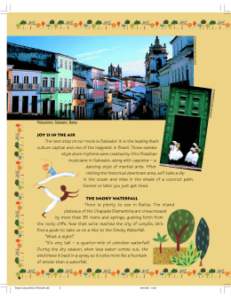
The Morro da Queimada Archaeological Park, Ouro Preto, MG Brazil.
B. T. Oliveira
PhD architecture and director of the Instituto do Patrimônio Histórico e Artístico Nacional - IPHAN, Ouro
Preto, MG, Brazil
ABSTRACT This paper deals with the creation of the Morro da Queimada Archaeological Park in Ouro
Preto, MG – Brazil. The Morro da Queimada constitutes an invaluable archaeological site, being an excellent
sample of the first architectonical typologies in town, for it keeps registers of the gold exploitation period at
the beginning of the 18th century and the vestiges of one of the most dramatic moments in the Brazilian colonial history. This project is coordinated by IPHAN and is supported by national and international institutions,
at the municipal, state and federal levels, as well as religious bodies, NGOs and community associations. It
was formally proposed by the Museu de Arte Sacra do Carmo, based at the Paróquia de Nossa Senhora do
Pilar and was approved by the Conselho Nacional de Incentivo à Cultura – CNIC (National Committee for
the Promotion of Culture), under the auspices of MinC – the Federal Ministry for Culture of Brazil.
1. INTRODUCTION
On April 18, 1881, during one of his many visits to
Ouro Preto, Dom Pedro II found an important archaeological site on Morro da Queimada (Burnt
Hill). The Emperor, erudite and widely-traveled,
wrote in his journal that these ruins reminded him of
Pompeii, the Roman city buried by the eruption of
Mount Vesuvius in 79 AD, discovered in 1748 and
today a famous archeological site, visited by specialists and tourists the world over.
The archaeological site of Morro da Queimada
similarly has its origin in tragedy. Also known as
“Morro do Paschoal” or the Village of Ouro Podre,
it was one of the earliest settlements in Ouro Preto.
It was destroyed in 1720, following the revolt led by
Felipe dos Santos against the increased taxes imposed by the Portuguese Crown through the prohibition of the circulation of gold powder and the establishment of royal minting houses in what was then
the Capitania of São Paulo and Minas Gerais. Ouro
Preto, then known as Vila Rica, rebelled during the
night of the 28th and the 29th of June, 1720. The situation deteriorated, and on July 2nd, 1720, more
than two thousand rebels marched on the Vila do
Carmo, today Mariana, with the intention of pressuring the Governor to repel the measures of the Portuguese Crown. At this point, the movement had already
spread to other communities such as Sabará and
Mato Dentro which went on to support the revolt.
The principal leaders of the revolt were Pascoal da
Silva Guimarães, Sebastião da Veiga Cabral, Dr.
Manuel Mosqueira da Rosa and his son, the Frei Vicente Botelho, and even the Frei Francisco do Monte
Alverne. According to the historian Diogo de
Vasconcelos, Felipe dos Santos, was “the only truly
popular leader” (Vasconcelos, D., p. 182 ) (Fig. 1).
The uprising lasted around eighteen days. On the
16th of July, the governor, the Count of Assumar,
entered Vila Rica at approximately eleven o´clock in
the morning at the head of fifteen hundred men.
Figure 1
The Execution of Felipe dos Santos, July 1720
Reconstruction by Antônio Parreiras
(Museu Antônio Parreiras, Niterói, RJ, Brazil)
After its destruction by fire on the orders of the
Count Assumar, the area was renamed Morro da
Queimada and the population transferred to the
nearby Arraiais.
According to Diogo de Vasconcelos, Felipe dos
Santos was arrested on either the 19th or 20th of
July, received a summary judgement and was executed. The other heads of the revolt were transferred
to Rio de Janeiro and there condemned to exile in
Lisbon, Portugal. At the time, the Governor, the
Count of Assumar, stated that even the very stones
of the Arraial of Ouro Podre plotted against the
Portuguese Crown.
As a result of the Sedição de Vila Rica in 1720,
the establishment of the proposed Royal minting
houses was postponed for four years, and Minas
Gerais became an administrative region independent
of the Capitania of São Paulo.
Morro da Queimada today constitutes a priceless
archaeological site, a concrete record of the first urban architectonical typologies of Minas Gerais, evidence of the gold rush at the beginning of the 18th
century, and a remnant of one of the most dramatic
moments in the history of Colonial Brazil. Besides
the ruins of old buildings, in the area may be found
the remains of the many gold mines that dot the hillside: hollowed shelters carved out of rock, long galleries, ventilation shafts, and entrance tunnels. Still
found on this archaeological site are mundéus, reservoirs constructed for the washing of ore, small
dams, water diversion channels, and hydraulic systems used for transporting slurries of water and mud
mixed with gold (Fig. 2).
Figure 2
Aerial view of Morro da Queimada in the mid-decades of the
20thcentury
(IPHAN archives, Ouro Preto, MG, Brazil)
2. THE DETERIORATION OF MORRO QUEIMADA
In recent decades, Morro da Queimada as an archaeological site has become corrupted due to the
chaotic growth of the City of Ouro Preto. In the absence of urban planning, the site was occupied, the
ruins being used by the population for building material, and the surviving structures employed as
foundations for new constructions (Fig. 3). The lack
of protection for the archaeological remains on
Morro da Queimada in Ouro Preto constitutes one
of the more serious cases of neglect of cultural heritage by the various levels of government.
Figure 3
Irregular occupation of Morro da Queimada
(IPHAN archives, Ouro Preto, MG, Brazil)
In April, 2003 a technical mission from UNESCO
on a visit to the city identified the preservation of the
archaeological site at Morro da Queimada as one of
the measures necessary to halt the alarming deterioration of the cultural and environmental heritage of
Ouro Preto.
3. THE RECOVERY PROJECT
Following this warning, the Instituto do Patrimônio
Histórico Artístico Nacional-IPHAN (National Institute for Historical and Artistic Heritage) established work groups (historical research, property issues,
Housing, physical planning, and community relations), necessary for the preparation of a pilot project for an archeological park in the area.
This project sought to create a substantial and
positive impact on the City of Ouro Preto by means
of the following:
- expansion of historical research and the creation
of programs for archaeological excavations, facilitating a wider knowledge of mining history and the
material culture of the period;
- protection and classification of the ruins dating
from the earliest settlements in Ouro Preto (Fig. 4);
- preservation of the memory of Felipe dos Santos and of the Sedição de Vila Rica in 1720;
- creation of a Ecomuseum (Community Museum) and archeological museum for the towns
which emerged during the “Gold Cycle”;
- creation of a unusual option distinct from the
traditional tourist circuit, to encourage visitors to
extend their stay in the area;
- protection of a meaningful part of the landscape,
including the urban and architectural complex of
Ouro Preto;
- improvement in the quality of life and social inclusion of the nearby communities, creating new
employment and business opportunities, as well as
ensuring the economic sustainability of the project.
requirements of the local population in the nearby
areas, so as to encourage social and cultural relationships that would facilitate social development based
on the elements of living space, society and heritage
(Fig. 6).
Figure 6
Creation of the Ecomuseum
(IPHAN archives, Ouro Preto, MG, Brazil)
Figure 4
View of part of the ruins at Morro da Queimada
(IPHAN archives, Ouro Preto, MG, Brazil).
During 2006 and 2007, various plans for public
works were developed, including the following:
- delineation of the area of the park and creation
of the park program (Fig.5);
- demolition of the recent constructions inside the
park; the families concerned were relocated to
new homes designed for improved quality of life;
Figure 5
Aerial view of the park: area of 124.88 hectares
(IPHAN archives, Ouro Preto, MG, Brazil)
- creation of an Ecomuseum, in line with the
At present, the Historical Research Group is working on the bibliographic classification of manuscript,
published and iconographic sources and on the
preparation of interview itineraries for the preliminary stages in collecting the oral history of the area.
After a critical reading and analysis of the sources
and bibliography, a work methodology will be established for drawing up a basic text on how to make
a qualitative approach to the space. Research in archives, libraries and technical reports on the history,
historiography and information management of the
Morro do Queimada will assist in making diagnoses
that will orient the process of setting up archaeological park, as well as in the elaboration of the central
theme to be incorporated in the urban planning directives for the City of Ouro Preto (Fig.7).
Figure 7
View of the ruins on Morro do Queimada, in the, in the mid
20thcentury
(Photo from Luiz Fontana IFAC archives, Ouro Preto, MG,
Brazil)
The Property Issues and Housing groups have already carried out the survey, transfer and new ar-
chitectural projects created for those families that
lived in the area designated for the creation of the
park. The families were compensated and can opt to
buy dwellings or lots for the construction of new
houses. The projects were developed with the participation of the Programa de Arquitetura Pública
(Public Architecture Programme) of the School of
Architecture of UFMG (Universidade Federal de
Minas Gerais), which seeks to align the education of
its students with the Brazilian reality, using both
theory and practice (Fig.8).
surroundings, taking on expressive and technological aspects appropriate for contemporary architectural languages, but that also make reference to the
typological and traditional construction characteristics.
The proposal must create a fruitful dialogue between the natural elements and the constructions in
such a way so as to produce a renovated and restated
landscape on the Morro da Queimada (Fig.9).
Figure 9
View of a mine entrance, 1990s.
(Photo from Germano Neto, Ouro Preto, MG, Brazil)
Figure 8
Demolition of irregular constructions
(IPHAN archives, Ouro Preto, MG, Brazil)
The Physical Planning Group has the responsibility of making interventions in a site of exceptional
natural beauty and significant archeological, historical and natural value. The first stage, already in progress, consists of drawing up proposals and studies
for the creation of the park, taking into consideration
its archaeological, historical, constructive, social,
visual, environmental and functional aspects, so as
to obtain information and subsidies for carrying out
the projects that involve physical intervention. The
interventions involve the identification, protection
and consolidation of the archaeological structures
and remains, as well as proposing solutions for environmental recovery, and guaranteeing the protection,
surveillance and security of the archaeological site.
The new structures will shelter programme activities and will be grouped in conformity with their
separate functions and by functional and environmental affinities: entrance and access, administrative
block, parking and cafeteria.
To articulate and connect these spaces, roads and
interpretative trails will be created that will impart
the
values existing in the park and its creation. Rest and
family areas, signage, and various types of communication, visual, mobile and lit, will be installed.
The architectural design proposes buildings that will
be sparse, transparent and inserted into the natural
The Community Relations Group is working with
various initiatives to involve the neighbouring communities in the project of creating the archaeological
park. For this the principles, concepts, methodologies and actions of the Ecomuseum will be used, so
as to meet the needs and desires of the neighborhoods that surround the archaeological site. The
principle function of this group is to establish a participative inventory of activities for the purpose of
diagnosing local potentialities and educational activities in the art education field; creative arts, theatrical arts, music, dance; handcrafts; sports and leisure. The expected result is a community project
aimed at a receptive tourism, sustainable culture, by
means of the experiences of an ecomuseum integrated with the archaeological park.
4. CONCLUSION
The challenge – to implant in the community a modern approach to sustainable development that takes
into consideration the preservation of the natural
and cultural heritage of the city – requires concerted
action from all parties concerned.
This project is supported by several public and religious institutions, including the following: The
United Nations Educational, Scientific and Cultural
Organization - UNESCO, Instituto do Patrimônio
Histórico Artístico Nacional - IPHAN, The Federal
University of Minas Gerais – UFMG, The Federal
University of Ouro Preto – UFOP, State Institute for
Historical and Artistic Heritage – IEPHA, the State
Forestry Foundation – IEF, the State Public Funding
Agency, Municipality of Ouro Preto – PMOP, Municipal Chamber of Ouro Preto – CMOP, the Gorceix Foundation, parish of Nossa Senhora do Pilar,
parish of Santa Efigênia and the Sociedade Soto Zen
do Brasil. In addition, there is support from various
NGO´s, such as the Associação de Proteção Ambiental Ouro Preto –APAOP (Ouro Preto Environmental Protection Association), the Amigos do
Patimônio Cultural e Natural de Ouro Preto - AMO
Ouro Preto (Friends of the Cultural and Natural
Heritage of Ouro Preto) and the Federação das Associações de Moradores de Ouro Preto- FAMOP
(Federation of Residents Associations of Ouro
Preto).
This project is coordinated by IPHAN, developed
in partnership with The Federal University of Ouro
Preto – UFOP, Municipality of Ouro Preto – PMOP,
Municipal Chamber of Ouro Preto – CMOP, managed by the Museu de Arte Sacra do Carmo, based
at the Paróquia de Nossa Senhora do Pilar, and
sponsored by the Programa Petrobras Cultural, the
Caixa Econômica Federal (Federal Development
Bank) and Novelis Brasil Ltda.
Morro da Queimada is a site endowed with rare
natural beauty, from where it is possible to obtain a
unique view overlooking the historical centre of
Ouro Preto (Fig. 10), and the Peak of Itacolomi,
which guided the first European settlers, the bandeirantes, to the area, , and, still to this day, a symbol
of the city (Fig.11).
The creation of the archaeological park of Morro da
Queimada will establish a setting favorable to the
recovery of the cultural and environmental heritage
of the city, a new start in the place where the city
began: the Arraial of Ouro Podre where once
Paschoal was master (Meirelles, C, p.55).
Figure 11
View of the Peak of Itacolomi from Morro da Queimada
(IPHAN archives, Ouro Preto, MG, Brazil)
REFERENCES
- Barker, P. 1981. Tecniche dello scavo archeológico.
Milano, longanesi & C.
- Bediaga, B. (org.). 1999. Diário do Imperador D. Pedro
II, viagem a Minas Gerais Vol. 24, – primeira parte,
26/03 a 19/04 de 1881. Petrópolis, Museu Imperial.
- De Varine, H. O Tempo Social. 1987. Rio de Janeiro,
Eça Editora.
- Meirelles, C. 1989. Romanceiro da Inconfidência. Rio
de Janeiro, Editora Nova Fronteira.
- Mello, S. de. 1985. Barroco Mineiro. São Paulo: Editora
Brasiliense. Belo Horizonte: Editora Rona, 1979.
- Vasconcelos, D. de. 1974. História Antiga de Minas
Gerais. Vol. II. Belo Horizonte: Editora Itatiaia.
- Vasconcellos, S. de. 1977. Vila Rica. São Paulo: Editora Perspectiva.
- Vasconcellos, S. de. 1979. Arquitetura no Brasil: sistemas construtivos. Belo Horizonte: Editora Rona.
Figure 10
View overlooking Ouro Preto from Morro da Queimada
(IPHAN archives, Ouro Preto, MG, Brazil)
The creation of the archaeological park of Morro da
Queimada is one of the most important recent undertakings in Ouro Preto, and the realization of this
project will be as important to the city as the Acropolis is for Athens or the Palatine Hill and the Ancient Forum are for Rome.
Baixar