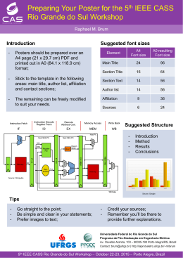
Biol Invasions
DOI 10.1007/s10530-007-9154-5
ORIGINAL PAPER
Predicting the potential distribution of the alien invasive
American bullfrog (Lithobates catesbeianus) in Brazil
João G. R. Giovanelli Æ Célio F. B. Haddad Æ
João Alexandrino
Received: 11 July 2007 / Accepted: 26 July 2007
Ó Springer Science+Business Media B.V. 2007
Abstract The non-native invasive anuran Lithobates catesbeianus is presently distributed in Brazil,
especially in the Atlantic Rainforest biodiversity
hotspot. Here, we use a maximum entropy ecological
niche modeling algorithm (i) to model the North
American native geographic distribution of this
species and (ii) to project that model onto the whole
of Brazil. After applying a threshold value that
balances commission and omission errors, the projection results suggested high probabilities of
occurrence mostly in southern and southeastern
Brazil. We also present the first report on the species
known distribution in Brazil, showing good agreement with model predictions. If the predictive map is
interpreted as depicting invasiveness potential of
L. catesbeianus, strategies to prevent further invasion
in Brazil should be focused especially in the Atlantic
Rainforest biodiversity hotspot.
Keywords Ecological modeling Exotic species Maxent Bioclim Anura American bullfrog
J. G. R. Giovanelli C. F. B. Haddad J. Alexandrino (&)
Herpetology Lab, Department of Zoology, UNESP-Rio
Claro, 13506-900, P.O. Box 199, Rio Claro, SP, Brazil
e-mail: [email protected]
Introduction
The American bullfrog (Lithobates catesbeianus
Shaw 1802) has been considered one of the most
harmful invasive species (Lowe et al. 2000). Native
to eastern North America, from southern USA up to
southern Canada, it was introduced, accidentally or
intentionally, into southern Europe, Asia and South
America (Bruening 2002). In Brazil, introductions
have occurred since the 1930’s in association with
aquaculture (Fontanello and Ferreira 2007). Presently
the species is usually recorded in the field across
several southern and southeastern localities (BorgesMartins et al. 2002), mostly in the Brazilian Atlantic
Rainforest (Dixo and Verdade 2006; Conte and
Rossa-Feres 2006). Whether this invasive species is
or not contributing to population losses in some
Brazilian native amphibians is unfortunately still a
matter of speculation (Young et al. 2001; Silvano and
Segalla 2005).
Ecological niche-modeling is a good tool to
assess potential geographic distributions of species
(Guisan and Thuiller 2005; Elith et al. 2006),
providing in some cases additional information for
conservation planning strategies and selection of
protection areas (Jeganathan et al. 2004; Young
2007). Ecological niche modeling has also been
applyed to the prediction of the invasive potential of
non-native species (Peterson and Vieglais 2001;
Peterson et al. 2003; Papes and Peterson 2003;
Ficetola et al. 2007).
123
J. G. R. Giovanelli et al.
The potential global distribution of L. catesbeianus
was recently predicted by Ficetola et al. (2007) but
their work was mostly aimed at predicting the
outcome of American bullfrog introductions (invasive or non-invasive) for well studied European nonnative populations. We here wish to contrast their
example with the rather poorly known non-native
populations of L. catesbeianus in Brazil, which
especially occur in the Atlantic Rainforest biodiversity hotspot. We use recently described ecological
niche modeling methods to generate a predictive map
for the distribution of L. catesbeianus in Brazil and
compare our results with the available information
for the actual Brazilian distribution of this frog.
Materials and methods
To produce an ecological niche model for the native
distribution of L. catesbeianus we took 784 georeferenced occurrence points in North America from
the Global Biodiversity Information Facility (2007)
and HerpNet (2007) databases, including occurrences
in Mexico, USA, and Canada (Fig. 1A). The data was
checked in the DIVA-GIS software (Hijmans et al.
2002) for bias and errors.
We used 19 bioclimatic and 1 topographic layers
as predictors. The bioclimatic variables result from
global land area interpolation of climate point data
(1950 – 2000 period) at a spatial resolution of
2.5 arc-min (Hijmans et al. 2005; available at
http://www.worldclim.org). The altitude variable
was derived from the U.S. Geological Survey’s
Hydro-K data set, at the same spatial resolution.
The realized ecological niche was modeled using
the Maxent software for species habitat modeling
(MAXENT; Phillips et al. 2006, software available at
http://www.cs.princeton.edu/*schapire/maxent). It
has been developed within the machine learning
community and it implements a general purpose
algorithm for making predictions and inferences from
incomplete information. The MAXENT algorithm
estimates geographic distributions of species from
locality point data by finding the maximum entropy
distribution (Phillips et al. 2006). MAXENT was
ranked among the most effective methods for species
distribution modeling from presence-only data in a
recent comprehensive model comparison study (Elith
et al. 2006).
123
The model was developed for occurrences within
the native distribution in North America and run over
the area represented by the inset in Fig. 1. Occurrence data were divided into training data, the 75% of
occurrence point data that was used for model
prediction, and test data, the 25% of occurrence
point data that was used for model validation. The
resulting model was evaluated with the Receiver
Operating Characteristics Curve (ROC) calculating
the area under the curve (AUC), a threshold independent index widely used in ecological studies. A
ROC plot is created by plotting the sensitivity values,
the true-positive fraction against 1-specificity, and the
false positive fraction for all available probability
thresholds (further reading: Fielding and Bell 1997,
Manel et al. 2001). The AUC is a measure of the area
under the ROC ranging from 0.5 (random accuracy)
to a maximum value of 1.0 (perfect discrimination).
The output of MAXENT is a continuous map
which allows fine distinctions to be made between the
modeled suitability of different areas. To generate a
binary (presence/absence) prediction map we used a
cumulative threshold value that balances training
omission, predicted area, and threshold value, i.e.,
balancing commission and omission errors (Phillips
et al. 2006).
The resulting model was projected onto both North
America and Brazil to assess the potential geographic
distribution of L. catesbeianus. Probabilities below
the threshold value were transformed to zero.
Projection results for Brazil were validated only in
areas where environmental conditions fall within the
range of the calibration area, to avoid spurious
projections (for details see Thuiller et al. 2004).
Finally, we plotted the actual species occurrence
points in Brazil (Appendix 1) on the predicted
Brazilian distribution map.
Results and discussion
Invasive species are one of the most important threats
to native communities (Begon et al. 1996). The
occurrence of Lithobates catesbeianus in areas of
the Brazilian Atlantic Rainforest is specially concerning because this biome is a biodiversity hotspot
(Myers et al. 2000). It is likely that L. catesbeianus
has deleterious effects to populations of native
amphibians and other organisms through competition
Predicting the potential distribution of an invasive species
Fig. 1 (A) Predicted
potential geographic
distribution for Lithobates
catesbeianus in North
America resulting from
Maxent climatic modeling
using occurrence records
within the species native
range. The inset is the area
of environmental
calibration for the purpose
of projecting the habitat
suitabilility model (see text
for details); (B) Projection
map for the potential
distribution of L.
catesbeianus in Brazil. Real
occurrence localities of the
species in distinct Brazilian
biomes are represented by
distinct polygon shapes or
shading (see legend in the
figure)
and predation (Moyle 1973; Kiesecker and Blaustein,
1998; Lowe et al. 2000).
Maxent modeling of 588 training and 196 testing
presence records, within the native range of
L. catesbeianus, yielded an AUC of 0.917 and
0.960, respectively for the the training and the test
data, suggesting high predictive power of the model.
Model probabilities below the threshold value of
4.689 were classified as predicted absence and
transformed to null values. The model projection
predicting occurrence in North America showed a
good agreement with both the species native distribution and the occurrence in non-native western
North America (Fig. 1A). The environmental variables that most influenced the predictions were, mean
diurnal range temperature, annual mean temperature
and precipitation of the driest quarter (results not
shown).
The projection of the native range distribution
model onto Brazil showed that predicted occurrence
included the actual distribution of L. catesbeianus in
southern and southeastern coastal areas of the
Atlantic Rainforest, but also suggested that areas in
central and northeastern Brazil could be colonized by
the species (Fig. 1B). Most of the Amazonian
environments were outside the model calibration
range for the species native distribution, albeit above
the model threshold value. Real occurrence is in good
agreement with the predicted Brazilian distribution
map with the few occurrences not predicted by the
123
J. G. R. Giovanelli et al.
model located in the Cerrado biome (Fig. 1B and
Appendix 1). Anecdotal information of failed L.
catesbeianus colonization exists for one of these
localities (Brandão and Rossa-Feres, personal communication; see Appendix 1 and Fig. 1B) but no
studies have ever examined the status of any introduced Brazilian population. Bioclimatic factors such
as low dry-season precipitation could be limiting the
species ability of invading areas away from the sites of
introduction in the Cerrado, but we cannot rule out that
other ecological factors (e.g. biotic interactions) would
concur for restricted or failed colonization. We expect
that the predicted distribution presented here provides
an hypothetical framework from which to derive
comparative investigations of population dynamics in
areas of occurrence predicted by the model and areas
of occurrence not predicted by the model.
If we conservatively assume that the predicted
distribution map presented here is a proxy for
invasion potential, southern and southeastern Brazil
must be considered especially sensitive because this
part of the Atlantic Rainforest is where bullfrog
aquaculture has been traditionally more widespread.
The understanding that both habitat suitability and
likelihood of human introduction for the invasive
American bullfrog coincide with areas hosting the
most diverse anuran communities in the planet should
urge both researchers and planners to act. Research is
needed to start understanding the dynamics of
American bullfrog populations in Brazil, while planning should focus on the eradication of invasive
populations and aquaculture farming control. The
production of bullfrog meat in aquaculture farms is a
profitable economic activity in Brazil (Feix et al.
2006) that will not be easily erradicated, but it should
be strictly regulated and monitored by the Brazilian
government to avoid further accidental introductions,
especially in areas more suitable for invasion.
Appendix 1 Occurrence points of Lithobates catesbeianus in
Brazil based on field work, the literature, museum collections
and personal communications (CFBH—Coleção de Anuros
Célio F. B. Haddad, Unesp, Rio Claro, SP, Brazil; DZSJRP—
Coleção do Departamento de Zoologia de São José do Rio
Preto, Unesp, São José do Rio Preto, SP, Brazil)
Municipality
Longitude
State
Biome
Acknowledgements We are grateful to Marinez Siqueira for
discussion and suggestions on early versions of the manuscript
and to Denise Rossa-Feres and Reuber Brandão for valuable
information about bullfrog distribution in Brazil. J. G. R.
Giovanelli was supported by NatureServe and CNPq
(# 130315/2007-9) schorlarships. This work was supported by
the FAPESP Research Grant # 05/52727-5 to J. Alexandrino,
and CNPq and FAPESP (01/13341-3) research grants to
C. F. B. Haddad.
Latitude
Source
Duque de Caxias
Rio de Janeiro
Atlantic Rainforest
43.30446°
22.58242°
Instituto Hórus (2007)
Cocal de Telha
Piauı́
Caatinga
41.98333°
4.53333°
Instituto Hórus (2007)
Santo Antônio do
Descoberto
Goiás
Cerrado
48.26030°
15.96968°
Brandão (pers. comm.)
Maceió
Alagoas
Atlantic Rainforest
35.74513°
9.62554°
Instituto Hórus (2007)
Vitória
Espı́rito Santo
Atlantic Rainforest
40.41272°
20.33107°
Instituto Hórus (2007)
Caratinga
Minas Gerais
Atlantic Rainforest
42.14000°
19.79000°
Instituto Hórus (2007)
Uberlândia
Viçosa
Minas Gerais
Minas Gerais
Cerrado
Atlantic Rainforest
48.27997°
42.88000°
18.90001°
20.76000°
Instituto Hórus (2007)
Instituto Hórus (2007)
Agudo
Rio Grande do Sul
Atlantic Rainforest
53.24992°
29.64157°
Instituto Hórus (2007)
Arroio do Tigre
Rio Grande do Sul
Atlantic Rainforest
53.09613°
29.33865°
Instituto Hórus (2007)
Barão
Rio Grande do Sul
Atlantic Rainforest
51.53456°
29.37932°
Borges-Martins et al. (2002)
Barracão
Rio Grande do Sul
Atlantic Rainforest
51.45442°
27.67698°
Instituto Hórus (2007)
Borges-Martins et al. (2002)
Caxias do Sul
Rio Grande do Sul
Atlantic Rainforest
51.16754°
29.17837°
Canela
Rio Grande do Sul
Atlantic Rainforest
50.80187°
29.35992°
Instituto Hórus (2007)
Derrubadas
Rio Grande do Sul
Atlantic Rainforest
53.85530°
27.26627°
Borges-Martins et al. (2002)
Dom Feliciano
Rio Grande do Sul
Atlantic Rainforest
52.11066°
30.69785°
Instituto Hórus (2007)
Dona Francisca
Rio Grande do Sul
Atlantic Rainforest
53.35898°
29.62626°
Instituto Hórus (2007)
Encantado
Rio Grande do Sul
Atlantic Rainforest
51.87989°
29.23984°
Instituto Hórus (2007)
123
Predicting the potential distribution of an invasive species
Appendix 1 continued
Municipality
State
Biome
Longitude
Latitude
Source
Estrela
Rio Grande do Sul
Atlantic Rainforest
50.98002°
28.10002°
Instituto Hórus (2007)
Estrela Velha
Rio Grande do Sul
Atlantic Rainforest
53.15368°
29.17225°
Instituto Hórus (2007)
Erechim
Rio Grande do Sul
Atlantic Rainforest
52.26892°
27.62956°
Borges-Martins et al. (2002)
Gravataı́
Rio Grande do Sul
Atlantic Rainforest
50.99000°
29.95000°
Borges-Martins et al. (2002)
Guaı́ba
Ibarama
Rio Grande do Sul
Rio Grande do Sul
Atlantic Rainforest
Atlantic Rainforest
51.32000°
53.12692°
30.11000°
29.42114°
Instituto Hórus (2007)
Instituto Hórus (2007)
Lajeado
Rio Grande do Sul
Atlantic Rainforest
51.95792°
29.44716°
Instituto Hórus (2007)
Muçum
Rio Grande do Sul
Atlantic Rainforest
51.86931°
29.16500°
Instituto Hórus (2007)
Nova Palma
Rio Grande do Sul
Atlantic Rainforest
53.47223°
29.47145°
Instituto Hórus (2007)
Nova Petrópolis
Rio Grande do Sul
Atlantic Rainforest
51.14000°
29.36000°
Borges-Martins et al. (2002)
Nova Roma do Sul
Rio Grande do Sul
Atlantic Rainforest
51.40667°
28.99972°
Instituto Hórus (2007)
Porto Alegre
Rio Grande do Sul
Atlantic Rainforest
51.22000°
30.04000°
Borges-Martins et al. (2002)
Santa Cruz do Sul
Rio Grande do Sul
Atlantic Rainforest
52.43371°
29.71577°
Instituto Hórus (2007)
Santa Maria
Rio Grande do Sul
Atlantic Rainforest
53.82853°
29.69524°
Instituto Hórus (2007)
Santa Tereza
Rio Grande do Sul
Atlantic Rainforest
51.74586°
29.16881°
Instituto Hórus (2007)
Taquari
Rio Grande do Sul
Atlantic Rainforest
51.86026°
29.80109°
Instituto Hórus (2007)
Tenente Portela
Rio Grande do Sul
Atlantic Rainforest
53.76015°
27.37591°
Borges-Martins et al. (2002)
Torres
Rio Grande do Sul
Atlantic Rainforest
49.75560°
29.34821°
Instituto Hórus (2007)
Veranópolis
Rio Grande do Sul
Atlantic Rainforest
51.56000°
28.94000°
Borges-Martins et al. (2002)
Viamão
Rio Grande do Sul
Atlantic Rainforest
50.98000°
30.09000°
Borges-Martins et al. (2002)
Campos Novos
Corupá
Santa Catarina
Santa Catarina
Atlantic Rainforest
Atlantic Rainforest
51.24860°
49.28181°
27.38399°
26.43266°
Present study (CFBH 13260)
Present study
Igrejinha
Santa Catarina
Atlantic Rainforest
50.80000°
29.58000°
Present study
Ipuaçu
Santa Catarina
Atlantic Rainforest
52.40806°
26.57067°
Present study (CFBH 7303)
Jaraguá do Sul
Santa Catarina
Atlantic Rainforest
49.10000°
26.48000°
Borges-Martins et al. (2002)
Campos do Jordão
São Paulo
Atlantic Rainforest
45.58008°
22.73046°
Instituto Hórus (2007)
Cotia
São Paulo
Atlantic Rainforest
46.95245°
23.74414°
Dixo and Verdade (2006)
Embu
São Paulo
Atlantic Rainforest
46.83191°
23.63990°
Present study (CFBH 11628)
Marı́lia
São Paulo
Cerrado
49.94580°
22.21390°
Present study (DZSJRP
2644–45)
Pariquera-Açu
São Paulo
Atlantic Rainforest
47.88330°
24.71670°
Present study (DZSJRP 4961)
Pedro de Toledo
São Paulo
Atlantic Rainforest
47.23137°
24.28726°
Present study (CFBH 12711)
Piracicaba
São Paulo
Transition Atlantic
Rainforest/Cerrado
47.64000°
22.71000°
Instituto Hórus (2007)
Rio Claro
São Paulo
Transition Atlantic
Rainforest/Cerrado
47.57117°
22.35471°
Present study
São José dos Pinhais
Paraná
Atlantic Rainforest
49.20640°
25.53470°
Present study (DZSJRP 6226)
São José do Rio Preto
São Paulo
Cerrado
49.37940°
20.81970°
Present study (DZSJRP 1806)
São Luı́s do Paraitinga
São Paulo
Atlantic Rainforest
45.13300°
23.34600°
Present study (CFBH 12159)
São Paulo
São Paulo
Atlantic Rainforest
46.64290°
23.77614°
Present study (CFBH 10155)
Suzano
São Paulo
Atlantic Rainforest
46.29992°
23.56980°
Present study (CFBH 5626)
Ubatuba
São Paulo
Atlantic Rainforest
45.13253°
23.49728°
Present study (CFBH 13375)
123
J. G. R. Giovanelli et al.
References
Begon M, Harper JL, Townsend CR (1996) Ecology: individuals, populations and communities. Blackwell Scientific
Publications, Oxford
Borges-Martins M, Di-Bernardo M, Vinciprova G, Measey J
(2002) Geographic distribution. Rana catesbeiana. Herpetol Rev 33:319
Bruening S (2002) Rana catesbeiana. In: Animal diversity
Web. University of Michigan Museum of Zoology.
Available at: http://www.animaldiversity.ummz.umich.
edu/site/accounts/information/Rana_catesbeiana.html.
Cited 24 April 2007
Conte CE, Rossa-Feres DC (2006) Diversidade e ocorrência
temporal da anurofauna (Amphibia, Anura) em São José
dos Pinhais, Paraná, Brasil. Rev Bras Zool 23:162–175
Dixo M, Verdade VK (2006) Leaf litter herpetofauna of the
Reserva Florestal de Morro Grande, Cotia (SP). Biota
Neotrop 6:0-0. On-line journal: http://www.biotaneotropica.
org.br/v6n2/pt/abstract?article+bn00806022006
Elith J, Graham CH et al (2006) Novel methods improve
prediction of species’ distributions from occurrence data.
Ecography 29:129–151
Feix RD, Abdallah PR, Figueiredo MRC (2006) Resultado
econômico da criação de rã em regiões de clima temperado, Brasil. Info Econ 36:70–80
Ficetola GF, Thuiller W, Miaud C (2007) Prediction and
validation of the potential global distribution of a problematic alien invasive species—the American bullfrog.
Diversity Distrib 13:476–485
Fielding AH, Bell JF (1997) A review of methods for the
assessment of prediction errors in conservation presence/
absence models. Env Conserv 24:38–49
Fontanello D, Ferreira CM (2007) Histórico da Ranicultura
Nacional. http://www.aquicultura.br/. Cited 22 Apr 2007
GBIF—Global Biodiversity Information Facility (2007) Free
and open access to biodiversity data. http://www.gbif.org/.
Cited 21 Apr 2007
Guisan A, Thuiller W (2005) Predicting species distribution:
offering more than simple habitat models. Ecol Lett
8:993–1009
Herpnet (2007) Specimens searching portal. http://www.
herpnet.org/. Cited 2 Jul 2007
Hijmans RJ, Guarino L, Rojas E (2002) DIVA-GIS. A geographic information system for the analysis of biodiversity
data. Manual—International Potato Center, Lima
Hijmans RJ, Cameron SE, Parra JL, Jones PG, Jarvis A (2005)
Very high resolution interpolated climate surfaces for
global land areas. Int J Climatol 25:1965–1978
123
Instituto Hórus (2007) Base de dados de espécies exóticas
invasoras no Brasil. http://www.institutohorus.org.br/
pr_trabalhos.htm. Cited 23 Apr 2007
Jeganathan P et al (2004) Modelling habitat selection and
distribution of the critically endangered Jerdon’s courser
Rhinoptilus bitorquatus in scrub jungle: an application of
a new tracking method. J Appl Ecol 41:224–237
Kiesecker JM, Blaustein AR (1998) Effects of introduced
bullfrog and smallmouth bass on microhabitat use,
growth, and survival of native red-legged frogs (Rana
aurora). Conserv Biol 12:776–787
Lowe S, Browne M, Boudjelas S, De Poorter M (2000) 100 of
the World’s worst invasive alien species a selection from
the global invasive species database. The Invasive Species
Specialist Group (ISSG), Auckland
Manel S, Williams HC, Ormerod SJ (2001) Evaluating presence-absence models in ecology: the need to account for
prevalence. J Appl Ecol 38:921–931
Moyle PB (1973) Effects of introduced bullfrogs, Rana
catesbeiana, on the native frogs of the San Joaquin
Valley, California. Copeia 1:18–22
Myers N, Mittermeier RA, Mittermeier CG, Fonseca GAB,
Kent J (2000) Biodiversity hotspots for conservation
priorities. Nature 403:853–858
Papes M, Peterson AT (2003) Predicting the potential invasive
distribution for Eupatorium adenophorum Spreng. in
China. J Wuhan Bot Res 21:137–142
Peterson AT, Vieglais DA (2001) Predicting species invasions
using ecological niche modeling: new approaches from
bioinformatics attack a pressing problem. BioScience
51:363–371
Peterson AT, Scachetti-Pereira R, Kluza DA (2003) Assessment of invasive potential of Homalodisca coagulata in
western North America and South America. Biota Neotrop 3:0-0:Online journal: http://www.biotaneotropica.
org.br/v3n1/pt/abstract?article+BN00703012003
Phillips SJ, Anderson RP, Schapire RE (2006) Maximum
entropy modeling of species geographic distributions.
Ecol Model 190:231–259
Silvano DL, Segalla MV (2005) Conservation of Brazilian
amphibians. Conserv Biol 19:653–658
Thuiller W, Brotons L, Araújo MB, Lavorel S (2004) Effects of
restricting environmental range of data to project current
and future species distributions. Ecography 27:165–172
Young BE (ed) (2007) Distribución de las especies endémicas
en la vertiente oriental de los Andes en Perú y Bolivia.
NatureServe, Arlington
Young BE, Lips KR, Reaser JK et al (2001) Population
declines and priorities for amphibian conservation in
Latin América. Conserv Biol 15:1213–1223
Baixar