ELABORATION OF THEMATICF MAPS OF GEOLOGY,
GEOMORPHOLOGY, PEDOLOGY, VEGETATION AND
LAND USE IN THE PEGMATITIC REGION PEGMATITIC
OF THE MUNICIPALITY OF PARELHAS (RN), BRAZIL
Paulo Sérgio de R. Nascimento,
Reinaldo A. Petta,
Thomas Campos
Laboratory of Geomática-Department of Geology-UFRN
{paulo, petta, thomascampos}@geologia.ufrn.br
INTRODUCTION
The municipal district of Parelhas
(State of Rio Grande do Norte - Brazil),
hostsconcentrates the great portion
part of the pegmatite occurrences of
the Borborema Pegmatite Province of
Borborema. However, the thematic
cartography in the municipal district is
scarce, mainly at in scales of 1:100000
or larger. In this context, it is imperative
that the production and the storage of
the geological information related to the
Pegmatite Mines, mainly for the new
projects, is beingthat has been developed
in for this very important mineral region.
The main objective of this study was the
generation of thematic maps (geology,
geomorphology, pedology, and vegetation
and land use) and the organization in a
geo-referenced GIS database, seeking
to store, to consult, to available, to
visualize, to manipulate, and to generate
information onf the mining activities in the
municipal district of Parelhas (RN). This
comprehensivegenerated database will be
used as a tool of technician-managerial
subsidy for the appropriate management
and operation of some projects of APL
Pegmatite (FINEP/CNPq/MME/MCT),
which that are being developed in this area
of mineral activity; this, program seeksing
the greatestlargest or broadest use of the
246
mineral resources, the prospectors’ safety,
and the minimization of the environmental
impacts.
MATERIALS AND METHODS
The necessary materials for the
development of this work were: topographic
map of Jardim do Seridó (SB.24-Z-B-V),
scale 1:100.000, Projection: UTM, Zone
24 (South), Datum SAD-69; orbital Image
TM/Landsat-5, orbit/point 215/65, dated of
03/02/2008 2008, bands 1 to 5 and 7; and
its computatcional geoprocessing program
(Geo-referenced Processing Information
System). The operationalizationlization
stages accomplished to reach the objective
of this work involvedcorresponded:
creation of georeferenced database
georeferenced; restoration and registration
of the Landsat image Landsat; contrast
techniques, emphasis and treatment of
satellite images; and compilation and
creation of the thematic maps.
The database is characterized by an
open system, where the information to be
stored can be useful tofor other researches
that use totally or partially, the same types
of information. In additionBesides, new
information can be inserted to compliement
those already in existencet or to accomplish
other configurations that are done necessary.
The first step, after defining the structure
Estudos Geológicos v. 19 (2), 2009
Paulo Sérgio de R. Nascimento
of the data bank, iswas the importing of the
cartographic base, specifically, the drainage
features (net)net and the hypsometry (with
equidistance of 50 meters), already in
the digital format;, they were imported
directly into the geo-referenced database.
SeveralSome edition adjustments were
accomplished in some interrupted curves
of level and without their altimetric values
and the drainage net was actualized and
completed with the TM images TM.
Before the registration of the images
is accomplished with the cartographic base
(topographic map of Jardim do Seridó), the
images passed by the restoration procedure
for the radiometric correction and increase
of the sizes of the pixels for 10m for 10m,
obtaining an enhanced image that and
with the triples of the spatial resolution
of the original images. This procedure
was accomplished in a project without
cartographic projection to guarantee that
the same ones were not adulterated and then
they were converted for the format GRIB,
registered and, only after, inserted in georeferenced database georeferenced. Using a
In computatcional geoprocessing program,
Geo-referenced Processing Information
System, the images were transformed by
PrincipleMain Components (PCA), that
besides concentrating the information of
all of the bands in PC1, it also possesses
the largest variance (larger contrast) and
medium more (larger shine). Besides,
the compositions colored 4R5G3B and
5R4G3B were accomplished enhanced by
lineal contrast.
The geology map was compiled and
adapted fromof CPRM (2007), from the
computer screenin the own screen of the
computer, because its was found in the digital format. The pegmatite occurrences
were then and inserted onto the pegmatite
occurrences mapped during the field work.
The geomorphology map was acquired
from accomplished with base in the geo-
Estudos Geológicos v. 19 (2), 2009
morphological base map geomorphological, in the digital format, at a in the scale of
1:1.000.000 fromof the Project RADAMBRASIL Project, which was updated fromin the scale of 1:100.000 scale with base
in the visual interpretation of the orbital
images and for field work. The pedology
map was derived from accomplished with
base in the soils base map at of soils, in the
scale of 1:1.000.000 scale from of the Project RADAMBRASIL Project and fromin
the map of average recognition and high
intensity of soils of a pilot area of the Nucleus of Desertification of Seridó, States of
Rio Grande do Norte and of Paraíba (EMBRAPA, 2002), scale 1:100.000 scale, that
it coversed a portion of the area; this was
used and with a base in the visual identification interpretation of the TM images TM
and for field interpretation recognition.
The map of vegetable covering
and land use was accomplished by the
visual interpretation of images usingwith
base in the photographic patterns and the
digitization of the thematic classes was
accomplished directly onin the computer
screen of the computer. The interpretation
of the images leaned mainly on these on
in the systematic techniques, with no field
visitsand in some map areas, so portions
no visited in field, the interpretation is
based on these key methods of the keys. It
is important to emphasize that the legend
of the classes was defined according to the
nomenclature adopted by IBGE (1992),
within the verifications in field at the
detailed nd in the working scale.
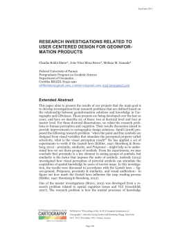
RESULTS
RelyingLeaning oin conceptual
and technological basies, an ambient
computatcional model was configured that
provided the storage of the cartographic
information related to the Pegmatite
mines in geo-referenced database geo-
247
ELABORATION OF THEMATICF MAPS OF GEOLOGY, GEOMORPHOLOGY, PEDOLOGY,
VEGETATION AND LAND USE IN THE PEGMATITIC REGION PEGMATITIC OF THE MUNICIPALITY
OF PARELHAS (RN), BRAZIL
referenced. Starting from the compiled
and generated maps, it was possible to
visualize the environmental physicalbiotic of the area and link thesee this to
obtain a cartographic base for the area,
that was non-existant before inexistent in
the area. The result of the registration was
considered satisfactory, because it obtained
an accuracy of 0,3 pixel, precision and
this is in agreement with the Pattern
of Cartographic Accuracy Established
Planimetric (BRAZSIL, 1996). The maps
generated are shown in the figures 1 to 4.
CONCLUSIONS
Concerning the development of this
research, the obtained results allowed us
to conclude that the objective of this work
was reached: to compile, to generate, to
organize, and to store in a single database
(GDB), the spatial information of the
municipal districts of Parelhas and Equador
(Borborema Pegmatite Province - RN) and
others regional districts, contributing to
the formation of a cartographic base, at a
in the scale of 1:100.000.
This generated database will be
used as a tool of technician-managerial
subsidy for the appropriate operation of
some projects of APL Pegmatite (FINEP/
CNPq/MME/MCT) that are being
developed in this area of mineral activity,
seeking the most efficientlargest use of
the the endowed mineral resources, the
prospectors’ safety, and the minimization
of the environmental impacts.
The generated maps (geology,
geomorphology, pedology, vegetation and
land use) made it possible to understand
know with considerably greaterlarger
detail the lithologic types, the relief
forms, the soil classes, and the coverings
of vegetation of the study area.
It is
important to pointstand out that, starting
from these generated maps, in a second
processing stage using techniques of
Geographical
Information
System,
they were integrated automatically, for
crossing referencings maps (denominated
of algebras of maps). This integration
made it possible to the generatei on of the
maps of environmental vulnerability and
natural vulnerability , that it will serve
as critical support for environmental
analyses, seeking to contribute the
establishment in appropriate ways of the
mining activities.
Figure 1. -Geological map of the municipal district of Parelhas (RN).
248
Estudos Geológicos v. 19 (2), 2009
Paulo Sérgio de R. Nascimento
Figure 2.- Geomorphologiycal map of the municipal district of Parelhas (RN).
Figure 3.-Pedologiycal map of the municipal district of Parelhas (RN).
Figure 4- Vegetation and land use map of the municipal district of Parelhas (RN).
Estudos Geológicos v. 19 (2), 2009
249
ELABORATION OF THEMATICF MAPS OF GEOLOGY, GEOMORPHOLOGY, PEDOLOGY,
VEGETATION AND LAND USE IN THE PEGMATITIC REGION PEGMATITIC OF THE MUNICIPALITY
OF PARELHAS (RN), BRAZIL
Acknowledgments
The authors of this work thank the
following institutes: to CNPq (National
Council of Scientific and Technological
Development)
and
to
FAPERN
(Foundation of Help to the Researches of
the State of Rio Grande do Norte) for the
financial support; and to the Laboratory of
Geomática of the Department of Geology
of the Federal University of Rio Grande do
Norte for the technological support.
REFERENCES
BRASIL, Ministério da Ciência e
Tecnologia e Comissão de Cartografia.
Cartografia e aerolevantamento –
legislação. Brasília, 1996,. p. 26-27.
CPRM - Companhia de Pesquisa
de Recursos Minerais - Serviço
Geológico do Brasil. Projeto
CPRM - UFRN. Disponível
em:
<http://www.cprm.gov.br/
publique/cgi/cgilua.exe/sys/start.
htm?infoid=100&sid=26>. Acesso:
07. Ago,. 2007.
250
DNPM. Departamento Nacional de
Pesquisas Minerais. Programa
nacional de distritos mineiros.
Recife: DNPM, 2002,. 108 p.
EMBRAPA. Empresa Brasileira
de
Pesquisa
Agropecuária.
Caracterização
dos
recursos
naturais de uma área piloto do
núcleo de desertificação do Seridó,
estados do Rio Grande do Norte
e da Paraíba. Rio de Janeiro:
EMBRAPA, 2002. Disponível
em:
<www.uep.cnps.embrapa.
br/publicacoes/bpd_04_caract_
serido_2002.pdf >. Acesso em:
15. out. 2007.
EMPARN - Empresa de Pesquisa
Agropecuária do Rio Grande do
Norte. Áreas de atuação. Disponível
em: <http://www.emparn.rn.gov.
br> . Acesso em: 1 out. 2007.
IBGE – Fundação Instituto Brasileiro
de Geografia e Estatística. Manual
Técnico da Vegetação Brasileira
(Manuais Técnicos de Geociências
n°01). Rio de Janeiro: IBGE. 1992,.
92p.
Estudos Geológicos v. 19 (2), 2009
Download