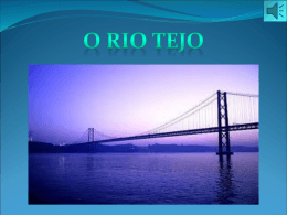
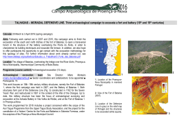
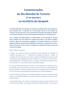
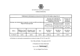
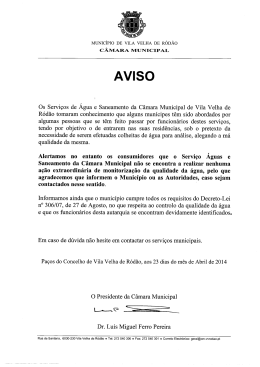
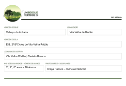
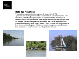
WALLED ENCLOSURE OF CHÃO DE GALEGO. 1st archaeological campaign (2nd to 1st millennium BC)
Calendar 16 August to 6 September 2015 (22 days)
Objectives To investigate a large walled archaeological site whose topographic location
suggests that it dates from the 1st millennium BC (Final Bronze Age). It may be a refuge
settlement, associated to a period of regional instability and conflict following the
establishment of the Phoenician trading posts on the coasts of the Iberian Peninsula. The
fieldwork includes various archaeological surveys, prospections, geophysical surveying
and three-dimensional scanning of structures. In addition to the research objectives, we
also aim to provide participants with the opportunity to learn excavation methodology for
this type of archaeological site.
Location Serra das Talhadas near the village of Chão de Galego, county of Proença-aNova, Intermunicipal community of Beira Baixa.
Programme Archaeological excavation (17 days) ■ Other field practices: 3D recording,
geophysical surveying and archaeological prospection (3 days) ■ Lectures (six) ■ Study
trips (three).
Archaeological excavation team Director of excavation: Francisco Henriques, João
Caninas and Paulo Félix ■ Sector coordinators and collaborators: to be appointed ■
Participants: 14.
The walled structures surrounding this archaeological site are popularly known as the
Estrada dos Mouros (“Moors’ Road”). They are located at the highest point of the Serra
das Talhadas, from where a broad horizon is visible as far as Serra da Estrela and the
lands of Spain, only limited in the north by the Central Cordillera (Alvelos Massif).
The site overlooks the village of Chão de Galego. Northwest of this enclosure is a cavity
known as Buraca da Moura (mine) and a shelter with prehistoric paintings.
1
2
1. Location of municipality of
Proença-a-Nova in mainland Portugal.
2. Site of accommodation: town of
Proença-a-Nova
(1).
Site
of
excavation: Chão de Galego (2): Sites
to visit: castro of Picoto (3); castro of
Portas de Ródão (4); castro of São
Miguel (5); castro of São Martinho and
Museum of Castelo Branco. The
outline delimits the territory of the
municipality of Proença-a-Nova. 3.
View of the archaeological site.
3
The most visible archaeological structures consist of two walls (marked with a red line in
Figure 2) around 400 m in extension, which enclose a broad polygonal space on a
quartzite syncline within which the geodesic slope of Galego (614 m) is located. They
consist of mounds of stones and earth.
The walls run diagonally across the depressions situated between two parallel rocky
crests with sharp escarpments on the outer sides and levels that vary between 520 m
and 590 m. The ends of the two walls stretch as far as the western and eastern
escarpments. These escarpments were appropriated as natural structures to enclose the
area. The Northern and Southern Walls were crossed by forest paths. The cut made in
the Southern Wall by the path is around 6 m wide at the base of the landfill.
At the top of the western crest, on rocky outcrops, and south of the Southern Wall, two
sites have been detected with rockfalls that might correspond to lookout structures.
There are two large falls of loose stone from the original site (quartzite). The first of these
is located between the two outcrops. On the top of it, there are two dry stone wall
structures forming a corner. The second occupies a crevice between two rocky outcrops
at the top of the same crest, where there is a platform delimited by lines of stone,
containing the eastern slope.
4
5
▼
The chronology of the site is not definitively established, but given its topographic
position, it may correspond to the beginning of the 1st millennium BC (Final Bronze Age).
It is hoped that this investigation will confirm the site’s status as a refuge settlement,
associated to the period of regional instability and conflict in the wake of the
establishment of Phoenician trading posts on the coasts of the Iberian Peninsula.
The archaeological intervention proposed will consist of excavations and geophysical
surveys inside the walled enclosure, prospections along the Talhadas mountains, and 3D
scans of various sites of the same uplands.
The programme also includes lectures and study trips to sites of regional archaeological
interest, culturally similar to the archaeological site being studied.
6
4. The position of the walls (North and South) of the Chão do Galego enclosure, marked with a red
line on the extract of Sheet 290 of the Military Map of Portugal. .
5. Northern line of the Northern Wall.
6. View from east to west of the development on the slope of the Northern Wall.
7. View of the site of implantation of the hypothetical lookout platform, observed from the Southern
Wall.
7
Programme
Day/month
Morning
Afternoon
16 August
17 August
9.00 pm. Reception of participants
9.00 am. Welcome session ■
10.00 am. Working methods
6.00 pm. Lecture A (introduction to the subject)
18 August
19 August
20 August
3.30 pm – 7.30 pm. Field trip A
Lectures ■ Subjects and speakers to be decided.
Other field practices ■ Prospections. ■ Three-dimensional scans of structures and rock
carvings. ■ Application of multi-spectrum photography to rock paintings.
6.30 am-1.00 pm. Excavation
21 August
4.00 pm – 7.00 pm. Other field practices A
22 August
6.00 pm. Lecture B
23 August
24 August
6.00 pm. Lecture C
25 August
26 August
Some texts about the Talhadas mountains and the Final Bronze Age settlement
Carvalho, D. L. (2011) Inventarição da geodiversidade da região das Portas do
Almourão (Vila Velha de Ródão e Proença-a-Nova, Geopark da Meseta Meridional)
contribuição para a sua inclusão na rede nacional de áreas protegidas. Açafa on
line,
4.
Associação
de
Estudos
do
Alto
Tejo.
84+54
p.
http://www.altotejo.org/acafa/docsn4/Inventariacao_Geodiversidade_Portas_do_Almoura
o.pdf
3.30 pm – 7.30 pm. Field trip B
6.30 am-1.00 pm. Excavation
27 August
28 August
4.00 pm – 7.00 pm. Other field practices B
29 August
6.00 pm. Lecture D
30 August
31 August
6.00 pm. Lecture E
1 Setembro
2 September
3.30 pm – 7.30 pm. Field trip C
6.30 am-1.00 pm. Excavation
3 September
4 September
4.00 pm – 7.00 pm. Other field practices C
5 September
6 September
Study trips A. Povoado of Serra de São Miguel, walled enclosure of Portas de Ródão
(Nisa) and viewing point of Portas de Ródão (Vila Velha de Ródão). B. Francisco
Tavares Museum in Proença Júnior and Povoado de São Martinho (Castelo Branco). C
“Castro” of Picoto and other walled enclosures of Serra do Muradal (Oleiros).
5.00 pm. Lecture F
6:30 pm. Delivery certificates
Departure of the participants
General timetable for
archaeological
excavations
Breakfast (starting at)
Departure for field
Start of field work
Morning break
5:30 am
6:00 am
6:30 am
9:30 am
Field work
Return home
Lunch
Dinner
10:00 am
1:30 pm
2:30 pm
8:00 pm
Lopes, S. S. coord. (2014) A Idade do Bronze em Portugal: os dados e os
problemas. Centro de Pré-História, Instituto Politécnico de Tomar. Antrope, 1, 317 p.
http://www.cph.ipt.pt/download/AntropeDownload/1_2014Serie%20Monografica/1_2014S
Mantrope.pdf
Henriques, F.; Caninas, J. & Gouveia, J. (2005). Serra das Talhadas. Fortins e
Baterias da Ponte do Alvito e da Ponte da Fróia. Catálogo da Exposição 25 Sítios
Arqueológicos da Beira Interior, Associação de Desenvolvimento Estudo e Defesa do
Património da Beira Interior (ARA) e Câmara Municipal de Trancoso. Trancoso, p. 44-45.
http://www.altotejo.org/UserFiles/File/Geral/SitiosArqueologicosBeiraInteriorSerradaTalh
adas.pdf
Henriques, F.; Caninas, J.; Sabrosa, A.; Henriques, F. R. & Gouveia, J. (2008). As
estruturas militares da serra das Talhadas na passagem de Ródão (Vila Velha de
Ródão e Nisa). Açafa on line, 1. Associação de Estudos do Alto Tejo. p. 29.
http://www.altotejo.org/acafa/docs/Estudos_e_Trabalhos/Estruturas_Militares_de_Rodao
.pdf
Henriques, F; Chambino, M.; Caninas, J.; Pereira, André & Carvalho, Emanel (2011).
Pinturas rupestres pré-históricas na Serra das Talhadas (Proença-a-Nova).
Primeira notícia. Açafa on line, 4 (2011). Associação de Estudos do Alto Tejo, p. 25:
http://www.altotejo.org/acafa/docsn4/Pinturas_rupestres_na_serra_das_Talhadas.pdf
Manso, João (2012). As Iniciativas do Município de Proença-a-Nova na Valorização
do Património Militar Construído. Açafa on line, 5, Associação de Estudos do Alto
Tejo. http://www.altotejo.org/acafa/docsn5/as_iniciativas_proenca_nova.pdf
Marques, L. P. (2012). Valorização e Divulgação das Estruturas Militares da Serra
das Talhadas – Projecto Integrado de Turismo Cultural e Paisagístico. Açafa on
line,
5,
Associação
de
Estudos
do
Alto
Tejo.
http://www.altotejo.org/acafa/docsn5/valorizacao_e_divulgacao_das_est_mil.pdf
Mascarenhas, A. J. (2012). A reacção dos Portugueses às Invasões Napoleónicas –
A Importância das Talhadas. Açafa on line, 5, Associação de Estudos do Alto Tejo.
http://www.altotejo.org/acafa/docsn5/reacoes_portugueses_as_invasoes_napoleonicas.p
df
Monteiro, M. & Pereira, A. (2008). O Forte das Batarias sobre a Ribeira do Alvito
(Proença-A-Nova). Análise Preliminar da Intervenção Arqueológica. Açafa on line, 1.
Associação
de
Estudos
do
Alto
Tejo,
p.
75.
http://www.altotejo.org/acafa/docs/Estudos_e_Trabalhos/O_Forte_das_Batarias.pdf
Monteiro, M. (2012). A Linha Defensiva das Talhadas-Moradal: um ensaio sobre a
tipologia das estruturas militares identificadas. Açafa on line, 5, Associação de
Estudos do Alto Tejo. http://www.altotejo.org/acafa/docsn5/linha_talhadas_moradal.pdf
Monteiro, M. (2013). A Linha das Talhadas-Moradal e o Sistema Defensivo de
Abrantes. Resultados dos Trabalhos de Prospecção Arqueológica e de Pesquisa
Documental. Açafa on line, 6, Associação de Estudos do Alto Tejo.
http://www.altotejo.org/acafa/docsn6/LINHA_TALHADAS_MORADAL_113_203.pdf
Monteiro, M.; Pereira, A. (2008). O Forte das Batarias sobre a Ribeira do Alvito.
Proença-a-Nova. Análise Preliminar da Intervenção Arqueológica. Açafa on line, 1,
Associação
de
Estudos
do
Alto
Tejo.
http://www.altotejo.org/acafa/docs/Estudos_e_Trabalhos/O_Forte_das_Batarias.pdf
Neto de Carvalho, C. & Rodrigues, J (2012) Património geológico de Proença-a-Nova:
caracterização e gestão no âmbito do Geopark Naturtejo. Açafa on line, 5.
Associação
de
Estudos
do
Alto
Tejo,
p.
178-230.
http://www.altotejo.org/acafa/docsn5/patrimonio_geologico_proenca_nova.pdf
Nunes, A. L. P. (2002). A Guerra dos Sete Anos e a Invasão Francesa na Beira
Baixa. Aspectos Militares. Açafa, 5, Actas do Colóquio “As Invasões Peninsulares e a
Região de Rodão”. (Vila Velha de Ródão, Maio de 2000). Associação de Estudos do Alto
Tejo, pp. 11-34.
Vilaça, R. (2013). O povoamento da Beira Interior durante o Bronze Final:
evidências, interacção e simbolismos. Estudos Arqueológicos de Oeiras, 20. Câmara
Municipal
de
Oeiras.
Oeiras,
p.
191-220
https://www.academia.edu/8108724/O_povoamento_da_Beira_Interior_durante_o_Bronz
e_Final_evidencias_interacao_e_simbolismos_Estudos_Arqueologicos_de_Oeiras_20_2
013
Vilaça, R. (2013). A Presença mediterrânea no mundo interior beirão, Centro de
Portugal (sécs. XI/X-VII/VI A.C.). In Arruda, A. M. (ed.). Fenícios e Púnicos, por Terra e
Mar: Actas do VI Congresso Internacional de Estudos Fenícios e Púnicos. Lisboa.
UNIARQ.
Vol.
I,
p.
396-411.
https://www.academia.edu/5555936/_A_presence_mediterranea_no_mundo_interior_bei
rao_centro_de_Portugal_secs._XI_XVII_VI_A.C._._In_Arruda_A.M._ed._Fenicios_e_Punicos_por_Terra_e_Mar._I_Actas_do
_VI_Congresso_Internacional_de_Estudos_Fenicios_e_Punicos_vol._1_2013_Lisboa_U
niarq-Estudos_e_Memorias_p._396-411
VV AA (2002). As Invasões Peninsulares e a Região de Ródão – Proença. Açafa, 5.
Associação de Estudos do Alto Tejo.
Baixar