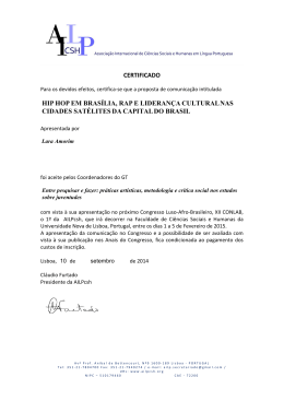
PORTUGAL
SECÇÃO PORTUGUESA DAS UNIÕES INTERNACIONAIS
ASTRONÓMICA E GEODÉSICA E GEOFÍSICA
(SPUIAGG)
INTERNATIONAL UNION OF GEODESY AND GEOPHYSICS
(IUGG)
NATIONAL REPORT
2003 – 2006
PRESENTED TO THE XXIV GENERAL ASSEMBLY
OF THE INTERNATIONAL UNION OF GEODESY AND GEOPHYSICS
HOLD AT PERUGIA, 2 – 3 JULY 2007
NATIONAL REPORT OF PORTUGAL
2003 – 2006
PRESENTED TO THE XXIV GENERAL ASSEMBLY
OF THE INTERNATIONAL UNION OF GEODESY AND GEOPHYSICS
Contents
1. Preface
(2 pages)
2. International Association of Geodesy (IAG)
(29 pages)
3. International Association of Seismology and Physics
of the Earth’s Interior (IASPEI)
(22 pages)
4. International Association of Geomagnetism
and Aeronomy (IAGA)
5. International Association for the Physical Sciences
of the Ocean ( IAPSO)
(5 pages)
(56 pages)
Preface
It is my pleasure to report the technical and scientific progresses reflecting very intensive
and large use of the improved technical facilities in all domains of the Associations’s
Activities.
The increasing participation of national specialists in Conferences, Symposia and General
Assemblies where the visibility of the Portuguese community was highlighted, can be seen as
a positive result of the large collaborative efforts developed in the period 2003-2006.
The support of the Association's Correspondents to prepare the National Report for the
2003-2006 period, was a valuable input, namely the IAG (International Association of
Geodesy), IASPEI (International Association of Seismology and Physics of the Earth's
Interior), IAGA (International Association of Geomagnetism and Aeronomy) and IAPSO
(International Association for the Physical Sciences of the Ocean). They produced wide
practical informations about the developments covering many scientific subjects and
challenges, that could be addressed by global remote sensing and modern information
technologies.
The seismic hazard assessments, based upon networks of continuously operating Global
Positioning System (GPS) receivers and SAR interferometry, during this last period the
Portuguese Scientific Community justify the efforts to use the geodetic techniques to study
the crustal movements, associated to the seismic activity and dynamic crustal displacements.
The implementation of the marine geophysics research is contributing to a better
understanding of the tectonic and tectonophysics structures, in southern areas of Portugal,
where the seismic hazard related to the activity expressed during historical periods by
impressive reports, such as the 1755 earthquake, continues to be the main objective of
projects funded by national agencies or financed in the framework of EU programs.
In the domain of the physical sciences of the ocean more projects were implemented on the
influence of the transport of sediments, their dynamics, their course and respective
consequences. Monitoring is increasing and more and more data is being collected.. The
amount of project reports issued by the different Portuguese Institutions involved and the
numerous publications are clear demonstration of the progresses achieved.
The concentration in the problems and implications of the biological production are
continuous source of interest and the Centers dedicated to the biology of the oceans maintain
a steady amount of publications treating those subjects.
More and more people are developing analytical methods to the mathematical representation
of phenomena, becoming the mainstream with several important and innovative works in
progress or recently concluded. Predictive models were implemented and tested.
Finally it is with great pleasure that the improvement of post-graduate academic degrees
continue to pursue in the Portuguese Universities, thanks to the support received from the
Portuguese Scientific Agencies and European Union.
Professor Dr. Luis Alberto Mendes-Victor, President of SPUIAGG
PORTUGAL
SECÇÃO PORTUGUESA DAS UNIÕES INTERNACIONAIS
ASTRONÓMICA E GEODÉSICA E GEOFÍSICA
(SPUIAGG)
INTERNATIONAL ASSOCIATION OF GEODESY
IAG
NATIONAL REPORT
2003 – 2006
PRESENTED TO THE XXIV GENERAL ASSEMBLY
OF THE INTERNATIONAL UNION OF GEODESY AND GEOPHYSICS
HOLD AT PERUGIA, 2 – 13 JULY 2007
Coordinated by
Eng. João Manuel Agria Torres,
National Correspondent of IAG
SPUIAGG, Rua Artilharia Um, 107, 1099-052 LISBOA, PORTUGAL
[email protected]
INTERNATIONAL ASSOCIATION OF GEODESY
NATIONAL REPORT OF PORTUGAL
1 – INTRODUCTION
The present report contains the information about the work carried out in Portugal in the field of
Geodesy, covering the period 2003-2006.
Each one of the following chapters is dedicated to the institutions (governmental agencies, universities
and research centres), who reported relevant geodetic work:
-
-
Instituto Geográfico Português (Portuguese Geographic Institute) - report by Eng. Maria Helena
Kol;
Instituto de Investigação Científica Tropical (Tropical Science Research Institute) - report by Dr.
Paula Santos;
Laboratório Nacional de Engenharia Civil (National Laboratory of Civil Engineering) – report by
Prof. João Casaca and Dr. José Nuno Lima;
Faculdade de Ciências da Universidade de Lisboa (Faculty of Sciences of the University of
Lisboa) – report by Prof. João Catalão;
Centro de Investigação em Ciências Geo-espaciais e Departamento de Matemática Aplicada da
Faculdade de Ciências da Universidade do Porto (Geo-Space Sciences Research Center and
Department of Applied Mathematics of the Faculty of Sciences of the University of Porto) – report
by Prof. José Pereira Osório;
Observatório Astronómico Prof. Manuel de Barros da Universidade do Porto (Astronomical
Observatory Prof. Manuel de Barros of the University of Porto) – report by Dr. Luisa Bastos.
It must also be mentioned the personal contribution to the work within the IAG structure, namely:
-
João Agria Torres (SPUIAGG) as President of EUREF, the Regional Reference Frame Subcommission for Europe of Commission 1 – Reference Frames.
2 – INSTITUTO GEOGRÁFICO PORTUGUÊS
2.1 – INTRODUCTION
The Instituto Geográfico Português (IGP) is an organism created in 2002, resultant of the union of
the former Portuguese Institute of Cartography and Cadastre and the former Portuguese Centre for
Geographical Information.
IGP is the organisation responsible for the establishment and maintenance of the national geodetic
reference frames. In its works are included:
• geodetic network;
• high precision levelling;
• tide gauges;
• gravimetric network;
• vertical deflection points’;
• GPS permanent network;
• calibration baselines.
2.2 – POSITIONING
2.2.1 – Geodetic Network - Mainland
In 2004 the observation with GPS of the second order network in Portugal mainland was completed.
The following standards were used to observe the 2nd order network:
•
•
•
•
•
4-5 double frequency GPS receivers;
2 hours sessions;
15 seconds epoch interval;
10 degrees elevation mask;
occupation of two 1st order points in each session.
The figure 1 shows the trig points of the mainland network already observed with GPS.
IUGG 2007
1/28
INTERNATIONAL ASSOCIATION OF GEODESY
NATIONAL REPORT OF PORTUGAL
1st
order
ETRS89
σ
lat
0.01 m
long
0.01 m
height
0.02 m
2nd
order
ETRS89
lat
0.03 m
long
0.03 m
height
0.04 m
Figure 1 – Mainland Geodetic network observed with GPS until the end of 2004.
2.2.2 – Geodetic Network - Madeira
The Geodetic network of Porto Santo island, in Madeira Archipelago - figure 2 - was measured with
GPS during October 2004. A total of twenty monumental geodetic points defines the Porto Santo
network. This field campaign also includes the realization of reciprocals and simultaneous zenithal
observations to improve precision in the height. The preliminary computation shows results (for
ITRF93) better than 2 centimetres (at 95% of confidence level) for the coordinates. Local Datum (Base
SE) coordinates were also computed, using the same set of observations. The Geodetic Network has
already been adjusted for Base SE coordinates, with the same precision as the ITRF93 coordinates.
Base SE
σ max (m)
N
0.022
E
0.022
O
0.022
ITRF 93
σ Max
φ
λ
O
0.013 (“)
0.013 (“)
0.010 (m)
Figure 2 – Porto Santo Island Geodetic network observed with GPS.
2/28
IUGG 2007
INTERNATIONAL ASSOCIATION OF GEODESY
NATIONAL REPORT OF PORTUGAL
2.2.3 – Geodetic Network - Azores
The Geodetic network of Corvo and Flores islands, in Azores Archipelago - figure 3 - was measured
with GPS during July 2005. A total of six monumental geodetic points defines the Corvo network and a
total of thirty tree monumental geodetic points defines the Flores network. The preliminary
computation shows results (for ITRF93) better than 4 centimetres in Corvo and 2 centimetres for the
coordinates of Flores (at 95% of confidence level). Local Datum (Observatório) coordinates were also
computed, using the same set of observations.
Corvo
ITRF 93
σ Max
0.04 m
0.04 m
0.04 m
Flores
ITRF 93
σ Max
Ν
0.02 m
Ε
0.02 m
0.02 m
Figure 3 – Corvo and Flores Islands Geodetic network observed with GPS.
2.3 – Tides Gauges
IGP is responsible for two floating tide gauges, at Cascais and Lagos, working since 1882 and 1908,
respectively. The Cascais tide gauge is the reference for the mainland ordnance datum.
Cascais
1882
Lagos
1908
L
IUGG 2007
3/28
INTERNATIONAL ASSOCIATION OF GEODESY
NATIONAL REPORT OF PORTUGAL
In 2003, due to the technological innovations and for a better service to the scientific community, IGP
acquired 2 new acoustic tide gauges, in order to replace the floating tide gauges systems. These new
systems will work simultaneously with the older ones for at least one year. In that way we assure a
better quality of the data and also the continuity of the secular series.
2003
Cascais
2.4 – Vertical Deflection Points’ Network
A network of about 130 vertical deflection points’ was observed with a prismatic astrolabe and a Wild
T4 theodolite until mid 1980s.
In 1998 a project for the re-observation and densification of this network was started in a co-operation
with ETH-Zürich (Swiss Federal Institute of Technology Zurich). The first work was the re-observation
of 25 stations with the Zenithal Camera of ETH-Zürich. In the subsequent year another 28 points were
observed with the ICARUS automatic system.
In 2000, following a protocol between IGP and FCUL, a special densification campaign along the
central part of Portugal was launched. During this campaign the ICARUS system has been put in
operation together with a GPS Palissade receiver, for timing porpuses. In the year 2001 another 11
stations were observed.
In 2004 in field campaign performed by Dr. Beat Bürki and Dr. Anna Müller of ETH in cooperation with
IGP, 17 points were measured with the new digital Zenith Camera system DIADEM.
Figure 4 shows the distribution of the vertical deflection points’ network and the methods of
observation. The stations related with the FCUL specific work are not indicated.
Figure 4 – Astronomical observations in Portugal Mainland.
4/28
IUGG 2007
INTERNATIONAL ASSOCIATION OF GEODESY
NATIONAL REPORT OF PORTUGAL
2.5 – GPS Permanent Network
The first GPS permanent station was installed in 1997 in Cascais near the tide gauge. In the beginning
of 2000 three more stations started to work: two near the tide gauges of Lagos and Leixões, and the
other in Ponta Delgada, Azores. All these 4 stations are included in the EUREF GPS Permanent
Network. The Ponta Delgada station also belongs to the International GPS Service Network.
The project of the GPS permanent network continued in the subsequent years with the installation of 5
other stations: Beja and Mirandela in 2001, Melriça and Funchal (Madeira Archipelago) in 2002, IGP in
2006. The configuration of the present GPS permanent network is shown in figure 5.
All the data regarding these 9 stations can be obtained at the anonymous ftp of IGP:
ftp://ftp.igeo.pt/pub/gpsdata/.
Figure 5 – GPS Permanent Network.
IUGG 2007
5/28
INTERNATIONAL ASSOCIATION OF GEODESY
NATIONAL REPORT OF PORTUGAL
2.6 – DETERMINATION OF THE GRAVITY FIELD
2.6.1 – Gravimetric Network
The gravimetric network of Portugal mainland consists of more than 6500 points, measured with
LaCoste & Romberg relative gravimeters, and has a density of about one point per 25 km2. In 1994
Dr. J. Mäkinen of the Finnish Geodetic Institute (FGI) had determined the absolute value of gravity in
Gaia and Mértola, with the JILAg-5 absolute gravity meter.
In 2003 Dr. Mäkinen came again to Portugal to perform an absolute gravity survey, this time with FGI's
new FG5 #221 absolute gravimeter. The Gaia and Mértola stations were re-measured, and a new
point was measured in Cascais, in the same building of the GPS permanent station and near the tide
gauge. The present state of the gravimetric network is shown in figure 6.
Gaia
Cascais
Mértola
Figure 6 – Gravimetric network of Portugal mainland.
6/28
IUGG 2007
INTERNATIONAL ASSOCIATION OF GEODESY
NATIONAL REPORT OF PORTUGAL
2.6.2 – Geoid Model - GPS on Levelling Bench Marks
In a joint project of IGP, FCUL and the Instituto de Astronomía y Geodesia de la Universidad
Complutense de Madrid (Spain), a new gravimetric geoid model was developed. The first results were
first presented at the 3rd Hispano-Portuguese Assembly of Geodesy and Geophysics, held in Spain in
2002.
In 2006, IGP promoted a GPS campaign with observations on 80 levelling bench marks, to complete
the full coverage of the country, since that only exists 26 measurements. The main goal of this project
was to adjust and validate the Portuguese gravimetric geoid model and also to contribute to the
EUVN_DA project.
.
Figure 7 – GPS on levelling bench marks in Portugal mainland
2.7 – HUMAN AND MATERIAL RESOURCES
The human resources of the Department of Geodesy of IGP are five surveying engineers and six
surveying technicians. The equipment consists on:
•
•
•
•
•
•
•
•
•
•
•
IUGG 2007
2 LaCoste & Romberg, model G gravimeters;
several dual-frequency GPS receivers;
several geodetic levels;
several optical-mechanics theodolites (astronomy, geodesy and surveying);
several computers;
Bernese GPS software;
GPS software;
gravimetry adjustment and computation software;
triangulation adjustment and computation software;
levelling adjustment and computation software;
geodetic astronomy adjustment and computation software;
7/28
INTERNATIONAL ASSOCIATION OF GEODESY
NATIONAL REPORT OF PORTUGAL
2.8 – PUBLICATIONS
•
Kol, H., Vasconcelos, M., Botelho, H. - Rede Nacional de Estações GNSS de observação
Contínua – Um projecto ao serviço de cidadão. Comunicação realizada no ESIG 2006 - IX
Encontro de utilizadores de informação geográfica, Oeiras, Portugal, 15 a 17 de Novembro de
2006.
• Silva, A, Crisóstomo, G., Freire, E., Costa, F. - Reflexões sobre a variação do Nível do Mar
em Portugal, 1ª Conferência Lusófona sobre o Sistema Terra, Lisboa, 22-24 de Março de
2006.
• Crisóstomo, G., Kol, M. H., Vasconcelos, M. – Marégrafos do IGP - Acústicos vs.
Analógicos, IV Conferência Nacional de Cartografia e Geodesia, Lisboa, Março 2005.
• Catalão, J., Kol, M. H., Sevilla, M. J., Anes, J. – IAGM04 - Geóide Centimétrico no Atlântico
Nordeste (Ibéria – Açores), IV Conferência Nacional de Cartografia e Geodesia, Lisboa,
Março 2005.
• Vasconcelos, M., Casaca, J. - A Transformação de Coordenadas Geodésicas entre o
Datum 73 e o ETRS89 por Predição Espacial, IV Conferência Nacional de Cartografia e
Geodesia, Lisboa, Março 2005.
• Vasconcelos, M., Martins, C., - Rede Geodésica Nacional: Estado Actual; Competências;
Informação de Cidadania, GisPlanet 2005, Lisboa, Portugal.
• Crisóstomo, G., Vasconcelos, M., Kol, H. – Novo Sistema de Aquisição de dados
Maregráficos do IGP, Resumos da 4ª Assembleia Luso Espanhola de Geodesia e Geofísica,
Figueira da Foz, Fevereiro 2004.
• Ribeiro, H., Martins, C., - Automatização das Estações Permanentes GPS do IGP,
Resumos da 4ª Assembleia Luso Espanhola de Geodesia e Geofísica, Figueira da Foz,
Fevereiro 2004.
• Martins, C., Ribeiro, H., - Observação da Rede Geodésica de 2ª Ordem com GPS,
Resumos da 4ª Assembleia Luso Espanhola de Geodesia e Geofísica, Figueira da Foz,
Fevereiro 2004.
• Vasconcelos, M., Casaca, J. - Análise Estatística das Coordenadas da Rede Geodésica
Portuguesa, Resumos da 4ª Assembleia Luso-Espanhola de Geodesia e Geofísica, Figueira
da Foz, Fevereiro 2004.
• Gonçalo C. Crisóstomo, Kol, H., Vasconcelos, M., - Referencial Altimétrico Nacional, XXI
Assembleia DIGSA, Lisboa, 22-26 de Novembro de 2004.
• Vasconcelos, M., Casaca, J., - Using Residuals for Improving the Accuracy of Coordinate Transformation, Simpósio EUREF 2004, Bratislava, Eslováquia, 2 a 5 de Junho de
2004. (a publicar).
8/28
IUGG 2007
INTERNATIONAL ASSOCIATION OF GEODESY
NATIONAL REPORT OF PORTUGAL
3 – INSTITUTO DE INVESTIGAÇÃO CIENTÍFICA TROPICAL
3.1 – INTRODUCTION
The origin of the Tropical Science Research Institute (IICT) dates from 1883 when a “Cartography
Commission” was created to promote the scientific study of the ancient Portuguese colonies in Africa
and to establish the basis for their scientific occupation. It was the first Portuguese institution devoted,
in a permanent way, to develop scientific research in the tropics.
Geodesy is one of the scientific areas covered by the activities of IICT. The geodetic work in Africa
(Angola, Mozambique, etc.) and in Asia was started more than 100 years ago. A systematic and wellorganized acquisition of geodetic data on the ground and its adequate mathematical treatment has
been carried out for many decades.
3.2 – RESEARCH & DEVELOPMENT PROJECTS
3.2.1 – Geodetic Network of Mozambique
This project has three main objectives. The first one is to update the classical geodetic triangulation of
Mozambique with GPS.The second is to conclude two lines of the geometric levelling network of
Mozambique. The third objective is to develop research studies with all geodetic data from the exMissão Geográfica de Moçambique.
Activities:
- Integration of the GPS observations in Mozambique Geodetic Network;
- Digitalisation of geodetic data field books to build a digital database.
- Adjustment of the classical terrestrial network of Mozambique in ITRF
3.2.2 – Geodetic Network of Angola
The objective of this project is the development of research studies with all geodetic data from the exMissão Geográfica de Angola
Activities:
- Observation of Luanda network with GPS
- Estimation of Bursa –Wolf parameters between Camacupa datum and ITRF for Luanda
3.3 – HUMAN AND MATERIAL RESOURCES
The human resources are two Researchers (PhD equivalent) .
The equipment consists on:
3 dual-frequency GPS receivers (Trimble 4000).
1 C/A code GPS receiver (Trimble Pathfinder Pro XL).
1 Gravimeter LaCoste & Romberg G.
2 Theodolite Total Stations
Several optical-mechanics theodolites (Astronomy, Geodesy and Surveying)
Several Geodetic Levels.
1 Portable Computer
Several Pentium Computers
Bernese GPS Software Version 4.2
GPSurvey Software (Trimble)
Gravimetry Adjustment and Computation Software (LaCoste & Romberg)
Gravimetry Adjustment and Computation Software (Finnish Geodetic Institute)
Triangulation Adjustment and Computation Software
Levelling Adjustment and Computation Software
1 Calcomp Plotter
1 Desk Scanner
IUGG 2007
9/28
INTERNATIONAL ASSOCIATION OF GEODESY
NATIONAL REPORT OF PORTUGAL
3.4 – PUBLICATIONS
Faria, B.V.E.,Fonseca, J.F.B.D., Heno, S.I.N, Lázaro, Clara, d´Oreye, N. ,Ferreira, Barros,
I.Santos, P., bandomo, Z, day, S.J., Osório J. PBaio, M., Matos, J. L “Multi-parameter
monitoring of Fogo island , Cape Verde” . Journal of Volcanology and Geotthermal Research.
2003, 125 , p 39 – 56.
Lázaro, Clara, Santos, Paula, Lima, J.Nuno, Heleno, Sandra N., Barros, Inocêncio, Matos João,
Baio, Miguel, Fonseca , João F.B.D.– “Detection of subsurface magma movements in Fogo
Volcano, Cape Verde, trough Microgravity observations. Proceedings of III Assembleia LusoEspanhola de Geodesia e Geofísica, Valencia, Spain, 2003. tomo II, pp 720-722
Lima, J.N., Heleno, S.I.N., Fonseca, J.F.B.D., - “Establishment of a GPS control network in
FogoVolcano, Cape Verde”. Proceedings of III Assembleia Luso-Espanhola de Geodesia e
Geofísica, Valencia, Spain, 2003. tomo I pp 114-117
Lima, J.N., Lazaro, C., Santos, P., Heleno, S.I.N., Fonseca, J.F.B.D., - “GPS and microgravimetry
for Fogo Island volcano control”. Proceedings of III Assembleia Luso-Espanhola de Geodesia e
Geofísica, Valencia, Spain, 2003. tomo I pp 297-300
Lima, J.N.– “O GPS na observação geodésica de Barragens – Resultados do 1º ensaio”. Laboratório
Nacional de Engenharia Civil, Relatório 157/05 - NGA/DBB, Lisboa 2005
Lima, J.N.–Henriques, Maria João, casaca, João – “ Monitorização de estruturas com GPS”. Livro
das actas da IV conferência Nacional de Cartografia e Geodesia, Lisboa 2005, Cartografia e
Geodesia 2005, Lidel pp 597-605.
Lima,J.N., Casaca,J., Henriques,M.J. – “Accuracy of Displacement Monitoring at Large Dams with
GPS”. Presented at the International Symposium on Geodetic Deformation Monitoring: From
Geophysical to Engineering Roles, Jaen, 2005, International Association of Geodesy Symposia,
Vol. 131, Springer-Verlag Berlin Heidelberg 2006, pp 239 – 243.
Lima, Nuno, Santos, Paula e Barros, F. Frias de - Instrumentos Geodésicos e Astronómicos
utilizados nas Antigas Missões Geográficas, “O Domínio da Distância”, Comunicação e
Cartografia, IICT 2006, pp 165 – 170.
Santos, Paula, Lima, J.N. – “Observação do troço Buzi-Zimuala com GPS para a conclusão do
ajustamento da Rede Geodésica de Moçambique” Livro das actas da IV conferência Nacional
de Cartografia e Geodesia, Lisboa 2005, Cartografia e Geodesia 2005, Lidel pp 587-596.
Santos, Paula, Lima, J.N., Quembo, J.L. – “Adjustment of the Classical Terrestrial Geodetic Network
of Mozambique tied to ITRF", 5th FIG Regional Conference for Africa - Accra, Ghana, March
2006 (http://www.fig.net/accra/).
Santos, Paula, Lima, Nuno e Barros, F. Frias de - Atribuições das Missões Geográficas instituídas
pela Comissão de Cartografia, “O Domínio da Distância”, Comunicação e Cartografia, IICT
2006, pp 171 – 189.
Santos, Paula, Barros, Frias de e Lima, Nuno - Catálogo dos Teodolitos usados nas Missões
Geográficas da antiga Comissão de Cartografia, “Comissão de Cartografia - Catálogos”, IICT
2006, pp 3 – 27.
10/28
IUGG 2007
INTERNATIONAL ASSOCIATION OF GEODESY
NATIONAL REPORT OF PORTUGAL
4 – LABORATÓRIO NACIONAL DE ENGENHARIA CIVIL
4.1 – R&D PROJECTS IN THE DOMAIN OF APPLIED GEODESY
Project: Geodesy Applied to the Observation of Engineering Works.
Abstract: The project, integrated in the Programmed Research Plan (Plano de Investigação
Programada - PIP) of LNEC, includes a set of R&D activities developed with the aim of supporting the
improvement and the updating of the important contribution provided, in a regular basis by the Applied
Geodesy Centre (Núcleo de Geodesia Aplicada – NGA), to the monitoring of large engineering works
(dams, bridges, etc.). The proposed project has a remarkable incidence in the engineering works
observation activity, carried out in the Departments of Dams, Structures and Geotechnics. The
geodetic observation activity plays an important role in the observation of engineering works, that doesn’t
exempt a constant renewal of the measuring equipment, operative methods, and methods and models for
the treatment of the observations. The central purpose of this project consists on the study and
improvement of the geodetic methods to the observation of large engineering works, essentially at two
levels:
i) equipments for geodetic observation (including a GNSS permanent station and multi-pillar baseline
in LNEC campus)
ii) methods and models for the treatment of the observed data and quality evaluation of
measurements and results.
4.2 – ORGANIZING A IAG/FIG SIMPOSIUM
LNEC and the “Local Organizing Committee” are organizing the symposium “Measuring the Changes”, to
be held in Lisbon, Portugal, from 12 to 15 May 2008 at LNEC Congress Center. Measuring the Changes”
(http://measuringchanges.lnec.pt) is integrated in the activities of IAG and FIG and combines the 4th IAG
Symposium on Geodesy for Geotechnical and Structural Engineering with the 13th FIG Symposium on
Deformation Measurements and Analysis.
The symposium will consist of both oral and poster presentations in three days, plus a one-day technical
tour. The topics include Monitoring Static and Dynamic Deformations of Engineering and Geotechnical
Structures, Multi-Sensor Systems, Automation of Monitoring and Warning Systems and Applications in
Geotechnical, Structural Engineering and in Geosciences at Local and Regional Scales.
Local Organizing Committee of “MEASURING THE CHANGES”
Maria João Henriques – President (LNEC)
Rui Manuel Fernandes (UBI)
José Nuno Lima (LNEC)
João Agria Torres (SPUIAGG)
Manuela Vasconcelos (IGP)
4.3 – PRESENTATIONS, ARTICLES AND OTHER R&D PUBLICATIONS IN THE DOMAIN OF
APPLIED GEODESY
Henriques,M.J., Casaca,J. – Monitoring Displacements at Large Dams by Means of Precision
Traverses. Presented in FIG Working Week 2003, Paris, 2003.
Henriques,M.J., Casaca,J.– Quality Control of a Large Dam Geodetic Monitoring System. Presented in
1st FIG International Symposium on Engineering Surveys for Construction Works and Structural
Engineering. Nottingham, 2004.
Casaca,J., Henriques,M.J. – Geodesia Aplicada à Monitorização de Barragens. Presented at the 4ª
Assembleia Luso Espanhola de Geodesia e Geofísica, Figueira da Foz, 2004.
Casaca,J., Henriques,M.J. – O Princípio de Fermat e a Refracção Vertical. Presented at the Congresso
de Métodos Computacionais em Engenharia, Lisboa, 2004.
Henriques,M.J., Santos,R., Silva,A., Coelho,J. – A Ambientação de Equipamento de Observação
Geodésica. Presented at the IV Conferência Nacional de Cartografia e Geodesia. Lisboa, 2005.
Henriques,M.J., Casaca,J. – A Importância do Quadro de Referência nos Sistemas de Observação
Geodésica de Grandes Barragens. Presented at the IV Conferência Nacional de Cartografia e
Geodesia, Lisboa, 2005.
IUGG 2007
11/28
INTERNATIONAL ASSOCIATION OF GEODESY
NATIONAL REPORT OF PORTUGAL
Lima,J.N., Henriques,M.J., Casaca,J. – Monitorização Geodésica de Estruturas com o GPS.
Presented Presented at the IV Conferência Nacional de Cartografia e Geodesia, Lisboa, 2005.
Casaca,J., Henriques,M.J. – The Impact of Vertical Refraction at Local Three-dimensional Engineering
Control Networks. Presented at the International Symposium on Geodetic Deformation
Monitoring: From Geophysical to Engineering Roles, Jaen, 2005.
Lima,J.N., Casaca,J., Henriques,M.J. – Accuracy of Displacement Monitoring at Large Dams with
GPS. Presented at the International Symposium on Geodetic Deformation Monitoring: From
Geophysical to Engineering Roles, Jaen, 2005.
Casaca,J., Henriques,M.J.; Fonseca,A.M., Lima,J.N., – A Geodesia Aplicada à Medição de
Deslocamentos em Grandes Barragens. Presented at the Seminário: Barragens - Tecnologia,
Segurança e Interacção com a Sociedade, Lisboa, 2005.
Caldeira,L., Casaca,J., Serra,J.B., Henriques,M.J., Lima,J.N. – A Utilização do GPS em Sistemas
de Aviso e Alerta em Grandes Barragens de Aterro. Presented at the XIII Congresso Brasileiro
de Mecânica dos Solos e Engenharia Geotécnica, Curitiba, 2006.
Lima,J.N., Henriques,M.J., Casaca,J., Coelho,J. - Medição de Deslocamentos Superficiais em
Barragens de Aterro com o GNSS - Presented at the 4as Jornadas Portuguesas de Engenharia
de Estruturas, Lisboa, 2006.
Casaca,J., Henriques,M.J. – Uncertainty in Convergence Measurements made by Motorized
Tacheometers in Tunnels. Presented at the 12th FIG Symposium on Deformation Measurements
and Analysis the 3rd IAG Symposium on Geodesy for Geotechnical and Structural Engineering,
Baden, 2006.
12/28
IUGG 2007
INTERNATIONAL ASSOCIATION OF GEODESY
NATIONAL REPORT OF PORTUGAL
5 – FACULDADE DE CIÊNCIAS DA UNIVERSIDADE DE LISBOA
5.1 – PROJECTS
Project: KARMA
Title: Kinematics And Rheological Modelling of the Nubian-Eurasian plate boundary in the Azores
Principal Investigator: João Catalão
Principal Research Unit: Laboratório de Tectonofísica e Tectónica Experimental - LATTEX
Period of activity: 1/Jun/2005 to 31/12/2008
Goals: The main goal of KARMA is to derive a cinematic model for the Azores plate boundary and to
design a comprehensive model for the Eurasia/Nubian plate boundary, valid at the "segment scale",
able to incorporate the main conclusions of a series of detailed and complementary approaches
supplied by other geophysical projects operating in this area. This will be achieved by the
development of an integrated technique, based on SAR interferometry, GPS surveys, continuous GPS
observations and rheological modelling, to evaluate inter-seismic, co-seismic and post-seismic
deformation. This will allow a reassessment of seismo-tectonics both in-land and offshore.
Project: ESA - Project C1P 3149
Title: Ground deformation of Azores islands based on INSAR, corner reflectors and GPS
Principal Investigator: João Catalão
Principal Research Unit: Laboratório de Tectonofísica e Tectónica Experimental - LATTEX
Period of activity: 1/Jun/2005 to 31/12/2008
Goals: The main objective of this project is to test the applicability of the corner reflectors to overcome
short term decorrelation of SAR images pairs. To reach this objective we proposed to install in Faial
island 6 corner reflectors.
DISPLAZOR, STAMINA and SARAÇORES projects, mentioned in the last report (1999-2002) have
already ended in 2005.
5.2 – Papers published in International Journals (with referees)
Catalão, J., J.M. Miranda, N. Lourenço (2006), “Deformation associated with the Faial (Capelinhos)
1956 eruption. Inferences from 1937-1997 geodetic measurements”. Journal of Volcanology
and Geothermal Research, Vol 155, 3-4, 151-163. doi:10.1016/j.jvolgeores.2006.03.028.
Catalão, J., (2006) “Iberia-Azores Gravity Model (IAGRM) using multi-source gravity data”. Earth,
Planets, Space, 58, 277–286, 2006.
Catita, C., K.L.Feigl, J. Catalão, J.M.Miranda, L.M.Victor (2005) “Time series analysis of SAR data
applied to the study of the co-seismic deformation of the 9th July 1998 Pico-Faial (Azores)
earthquake” International Journal of Remote Sensing, Vol. 26, No 13, 10 July 2005, 2715-2729.
Catalão, J. and M.J. Sevilla (2004), “Inner and minimum constraint adjustment of marine gravity data”.
Computers and Geosciences, Vol.
30, Issues 9-10 pp. 949-957, DOI:
10.1016/j.cageo.2004.06.004
Navarro, A., J. Catalão, J.M. Miranda and R. M.S. Fernandes (2003) “Estimation of the Terceira island
(Azores) main strain rates from GPS data”. Earth, Planets and Space, Vol. 55 (10), pp. 637-642.
Antunes, C., R. Pail, J. Catalão (2003) “Geoid determination by point mass method”. Studia
geophysica et geodetica, Vol. 47, pp. 495-509.
Mendes, V.B. and E.C. Pavlis (2004). “High-accuracy zenith delay prediction at optical wavelengths”.
Geophysical Research Letters, Vol. 31, L14602, doi:10.1029/2004GL020308.
5.3 – Communications to International Meetings
(with Publication of Extended Abstract or Publication of Communication on Acta Book)
Antunes, C., 2004. Linear formulation of the gravity space approach for local geoid determination.
Proceedings of the 1st Workshop on International Gravity Field Research, Graz, Austria, May 89. Eds. Bruno Meurers and Roland Pail, Österreichische Beiträge zu Meteorologie und
Geophysik, Heft 31, Vienna 2004, p. 79-85.
IUGG 2007
13/28
INTERNATIONAL ASSOCIATION OF GEODESY
NATIONAL REPORT OF PORTUGAL
Hulley, G., E.C. Pavlis, V.B. Mendes, and D.E. Pavlis (2005). “Multiwavelength refraction modeling
improvements for SLR observations” Proceedings of the 14th International Laser Ranging
Workshop, June 7 - 11, 2004, San Fernando, Cadiz, Spain, Boletin ROA No. 5/2005, J. Garate,
J. M. Davilla, C. Noll and M. Pearlmann (Eds), Real Instituto y Observatorio de la Armada, San
Fernando, Spain, pp. 301-309.
5.4 – Communications to National Meetings
(With Publication of Extended Abstract or Publication of Communication on Acta Book)
Catita, C., J. Catalão, M. Miranda, L.M. Víctor (2004). O sismo de 9 de Julho de 1998, Pico-Faial
(Açores): deformação co-sísmica observada a partir de interferometria radar. Actas da III
Conferência Nacional de Cartografia e Geodesia in December of 2002, Aveiro, Portugal. Lidel,
Edições Técnicas, pp. 243-250.
Prates, G. e V.B. Mendes (2004). “Análise de estratégias de processamento de dados GPS.” Actas da
III Conferência de Cartografia e Geodesia, 5-6 de Dezembro, Aveiro, Lidel – Edições Técnicas,
Lda, pp. 97-102.
Mendes, V.B., J. Madeira, J. Pagarete, G. Prates, A. Trota, P. Elósegui (2004). “Estabelecimento de
uma rede GPS de controlo de deformações no Faial, Pico e S. Jorge.” Actas da III Conferência
de Cartografia e Geodesia, 5-6 de Dezembro, Aveiro, Lidel – Edições Técnicas, Lda, pp. 127131.
Rodrigues, R., V.B. Mendes, A. Trota, J.L. Gaspar e P. Amaral (2005). “Aplicação da técnica GPS no
estudo da deformação dos sistemas vulcano-tectónicos da ilha graciosa (Açores).” APMG
2005, 4.º Simpósio de Meteorologia e Geofísica da Associação Portuguesa de Meteorologia e
Geofísica, 6.º Encontro Luso-Espanhol de Meteorologia, 14 - 17 Fevereiro 2005, Sesimbra, pp
122-126.
5.5 – Communications to National and International Meetings
(Without Publication of Extended Abstract or Publication of Communication on Acta Book)
Calvão, J. (2006). "Generation of a high resolution grid of gravity anomalies by inversion of altimetric
data from Geosat, Topex/Poseidon, ERS-1/2 and Jason-1 in the Azores region". Presented at
the ESA meeting "15 Years of Progress in Radar Altimetry", 13-18 March, Venice
Catita, C., J. Catalão, M. Miranda, L.M. Victor, R.M. Fernandes (2005). Cinemática e deformação das
ilhas do Faial e Pico (Açores). IV Conferência Nacional de Cartografia e Geodesia, Março de
2005, Centro de Congressos do LNEC, Lisboa.
Antunes, C., 2003. "Linear formulation of the gravity space approach on local geoid determination". 1st
Workshop International Gravity Field Research, Graz, Austria, May 8-9.
Antunes, C., 2004. A combined linear formulation of the boundary-value problem in the gravity space
applied to local geoid determination. IAG International Symposium - Gravity, Geoid and Space
Missions - GGSM2004. Porto, Portugal, Aug. 30th - Sept. 3th.
Antunes, C. 2006. “Problema Combinado de Fronteira na Abordagem do Espaço Gravidade “. 5ª
Assembleia Luso-Espanhola de Geodesia e Geofísica, Sevilla, Espanha, Fev 28 – Mar 3.
Sousa, C. e Catalão, J. (2006) “A integração do sistema GPS/INS para a monitorização da linha de
Costa do Litoral do Algarve.” In: IX Encontro de Utilizadores de Informação Geográfica, 15-17
Novembro 2006, Tagus Park, Oeiras, publicado em CD-ROM, 11 páginas.
Catalão, J., Sevilla, M.J., Calvão, J. (2006), “ICAGM – Geóide no Atlântico nordeste (Ibéria – Canária
- Açores)”. In: Proceedings of V Assembleia Luso Espanhola de Geodesia e Geofísica e
Coordenador da sessão Geodesia - “?????”, realizada em Sevilla, Fevereiro 2006. ISB 848320-373-1.
Catalão, J., H. Kol, M. J. Sevilla, J. Anes (2005), “IAGM04 – Geóide centimétrico no Atlântico
Nordeste (Ibéria – Açores)”. IV Conferência Nacional de Cartografia e Geodesia, Sessão ....,
LNEC, Lisboa, Março 2005.
14/28
IUGG 2007
INTERNATIONAL ASSOCIATION OF GEODESY
NATIONAL REPORT OF PORTUGAL
NAVARRO, A., J. CATALÃO e J.M. MIRANDA (2005). Estimação das taxas de deformação e de
rotação local da ilha da Terceira com base em observações GPS. Comunicação apresentada
na IV Conferência Nacional de Cartografia e Geodesia, 10 e 11 de Março de 2005, LNEC.
Catalão, J., J.Fernandes and L. Bastos (2004), “Mapping Multi-source Gravity Data using Optimal
Interpolation”. IAG International Symposium: Gravity, Geoid and Space Missions - GGSM2004.
Sessão 5 - Topographic data bases and gravity modeling. Porto, 2004.
Catalão, J., H. Kol, M. J. Sevilla, J. Anes, (2004), “Towards a cm-geoid for the North-East Atlantic
(Iberia – Azores)”. IAG International Symposium: Gravity, Geoid and Space Missions GGSM2004. Sessão 3 - Regional geoid modeling. Porto, 2004.
Mäkinen, J., L.Bastos, P. Baptista, J. Catalão,H. Kol,R. Vieira, (2004) “Absolute gravity measurements
in the Azores and in the Iberian Peninsula”. IAG International Symposium: Gravity, Geoid and
Space Missions - GGSM2004. Sessão 7 - Terrestrial gravity instrumentation, networks, and
geodynamics. Porto, 2004.
Catalão, J.; Catita, C.; Miranda, J.M.; Pinto, J. (2003), “Reanalysis of the deformation associated with
Capelinhos eruption (Faial island, 1958) from geodetic data”. XXVIII General Assembly of the
EGS, Session G12; Vol. 5, 8604, 6-11 April, Nice, France.
Feigl, K., Retina Team (J. Catalão) (2003), “Mechanical coupling between eartquakes, volcanos and
landslides”. XXVIII General Assembly of the EGS, Session G12; Vol. 5, 04677, 6-11 April, Nice,
France.
NAVARRO, A., J. CATALÃO, R. FERNANDES, M. MIRANDA, L. BASTOS (2003). The Terceira Island
(Azores) crustal deformations from GPS data. Geophysical Research Abstracts, Vol. 5, 10082,
European Geophysical Society 2003.
Mendes, V.B., I. Fortes, and P. Elósegui (2003). “Accuracy assessment of IGS zenith tropospheric
delays.” Presented at the AGU 2003 Fall Meeting, 8-12 December, S. Francisco, CA. (Eos
Trans. AGU, 84(46), Fall Meet. Suppl., Abstract G51B-0026).
Rodrigues, R., P. Amaral, A. Trota , J.L. Gaspar e V. B. Mendes (2004). “Implementação de uma rede
geodésica na ilha Graciosa (Açores) para avaliação da actividade sismovulcânica.”
Apresentada na 4ª Assembleia Luso-Espanhola de Geodesia e Geofísica, Figueira da Foz, 3-7
de Fevereiro de 2004 (Livro de Resumos: pp. 627-628).
Pavlis, E., V.B. Mendes, D.E. Pavlis, and G. Hulley (2004). “Atmospheric refraction modeling
improvements in satellite laser ranging” European Geosciences Union 1st General Assembly,
Nice, France, 25 - 30 April 2004, Geophysical Research Abstracts, Vol. 6, 04206, 2004.
Trota, A., R. Rodrigues, P. Amaral, J.L. Gaspar, and V. B. Mendes (2004). “GPS continuous
observations at S. Miguel and Terceira islands (Azores). Preliminary results” Tenerife,
International Symposium “Reducing Volcanic Risk in Islands”. Tenerife, 1-7 June 2004.
Hulley, G., E.C. Pavlis, V.B. Mendes, and D.E. Pavlis (2004) “Validation of atmospheric refraction
modeling improvements in satellite laser ranging.” Presented at the AGU 2004 Fall Meeting, 1317 December, S. Francisco, CA. (Eos Trans. AGU, 85(47), Fall Meet. Suppl., Abstract G31A0784).
Hulley, G., E.C. Pavlis, V.B. Mendes, and D. E. Pavlis (2005). “Improved atmospheric refraction
modeling for Satellite Laser Ranging: Model validation.” EGU General Assembly, 24 – 29 April
2005, Vienna, Austria (Geophysical Research Abstracts, Vol. 7, 05693).
IUGG 2007
15/28
INTERNATIONAL ASSOCIATION OF GEODESY
NATIONAL REPORT OF PORTUGAL
6 – CENTRO DE INVESTIGAÇÃO EM CIÊNCIAS GEO-ESPACIAIS E DEPARTAMENTO DE
MATEMÁTICA APLICADA DA FACULDADE DE CIÊNCIAS DA UNIVERSIDADE DO PORTO
6.1 – MAIN AREAS OF ACTIVITY IN GEODESY
The activity at the Geo-Space Sciences Research Centre (CICGE) and Applied Mathematics
Department, Faculty of Sciences, University of Porto, in the area of Geodesy and related fields, is
organized around four main domains:
Satellite Positioning and Navigation
Satellite Altimetry
Remote Sensing and Image Processing
Geographical Information Systems
In the period covered by this report, 2003-2006, the activity was carried out, in all those domains and
their applications, through research projects financed by national as well as international
organizations. Some of the results from such activity are given in the annexed list of publications.
The two Masters Degree Courses, in Satellite Positioning and Navigation and in Remote Sensing,
continue to be offered. The MSc Thesis produced during the same period are also included in the list.
Also in the list, are the PhD Thesis, already finished, whose research work was conducted under the
supervision of elements of the Research Centre, within the area of geodesy and related fields.
Finally, it is also to be mentioned the organization of some International Meetings under the
responsibility of members of the Centre.
6.2 – PUBLICATIONS
2003
Joao F.B.D. Fonseca, Bruno V.E. Faria, Nuno P. Lima, Sandra I. N. Heleno, Clara Lazaro, Nicolas F.
d´Oreye, Ana M. G. Ferreira, Inocencio J.M. Barros, Paula Santos, Zuleyka Bandomo, Simon J. Day,
Jose P. Osorio, Miguel Baio, Joao L.G. Matos, 2003, “Multiparameter Monitoring of Fogo Island, Cape
Verde, for Volcanic Hazard Mitigation”, Journal of Volcanology and Geothermal Research 2605, pp. 118.
Nekrassov A. 2003, Airborne measurement of the sea surface wind vector by a microwave radar
altimeter at low speed of flight. IEICE Transactions on Electronics, 2003, Vol. E86-C, No. 8, pp. 15721579.
André R. S. Marçal, Janete Borges, 2003, AVHRR Rectification Using Orbital Navigation and Image
Matching, Image and Signal Processing for Remote Sensing VIII, edited by Sebastiano B. Serpico,
Proceedings of SPIE Vol. 4885, 13-21.
Lima, José Nuno, João Agria Torres, Maria Helena Kol, 2003, “Geo-responsabilização: o que
podemos esperar da nossa infra-estrutura geodésica e em que condições a podemos utilizar?”, Actas
da III Conferência Nacional de Cartografia e Geodesia, Cartografia e Geodesia, Lidel, Lisboa 2003, pp
395-405.
Lázaro, C., P. Santos, J. N. Lima, S. N. Heleno, I. Barros, J. Matos, M. Baio e J.F. B. D. Fonseca,
2003, “Detecção de movimentos sub-superficiais de magma no Vulcão do Fogo, Cabo Verde, através
das observações de microgravimetria”, Proceedings da 3ª Assembleia Luso-Espanhola de Geodesia
e Geofísica, Tomo II, Valência, Espanha, pp 720-722.
Lima, J. Nuno, S.I.N. Heleno, J. F. B. D. Fonseca, 2003, “Estabelecimento da Rede GPS para o
controlo do Vulcão do Fogo, Cabo Verde”, Proceedings da 3ª Assembleia Luso-Espanhola de
Geodesia e Geofísica, Tomo I, Valência, Espanha, pp 114-117.
Lima, J. Nuno, Clara Lázaro, Paula Santos, S.I.N. Heleno, J.F.B.D. Fonseca, 2003, “GPS e
microgravimetria no controlo do Vulcão da Ilha do Fogo”, Proceedings da 3ª Assembleia LusoEspanhola de Geodesia e Geofísica, Tomo I, Valência, Espanha, pp 297-300.
16/28
IUGG 2007
INTERNATIONAL ASSOCIATION OF GEODESY
NATIONAL REPORT OF PORTUGAL
Fernandes M. J., L. Bastos and M. Antunes, 2003, Coastal Satellite Altimetry – Methods for Data
Recovery and Validation, Proceedings of the 3rd Meeting of the International Gravity & Geoid
Commission (GG2002), 302-307, Tziavos, I. N. (Ed.), Editions ZITI.
Fernandes M. J and M. Antunes, 2003, Eight Years of Satellite Radar Altimetry in The Northeast
Atlantic – Proceedings 3ª Assembleia Luso-Espanhola de Geodesia e Geofísica, Vol I, 226-230,
Garcia F. and Valero, J.(ed,), Editorial UPV.
Fernandes M. J., 2003, Satellite Altimetry Data Recovery In Coastal Regions – Proceedings 3ª
Assembleia Luso-Espanhola de Geodesia e Geofísica, Vol I, 231-235, Garcia F. and Valero, J.(ed,),
Editorial UPV.
Alexandre Gomes, André R. S. Marçal, 2003, Land cover revision through object based supervised
classification of ASTER data, ASPRS 2003 Annual Conference Proceedings, May 2003, Anchorage,
Alaska, CD-ROM, 9 pp.
Gonçalves, J., 2003. Orientation of SPOT stereopairs with a SAR image for DEM extraction.
Proceedings of the Annual Conference of the American Society of Photogrammetry and Remote
Sensing (CD-ROM).
Borges, J., Costa, J., Marçal, A., 2003, Classificadores e Máquinas de Suporte Vectorial em Imagens
Multi-espectrais, Actas da JOCLAD 2003: X Jornadas de Classificação e Análise de Dados, 36-41.
Fernandes, M. J., L. Bastos, F. Leite, 2003, Integration of Multisensor Gravity anomalies, IUGG2003,
Sapporo, Japan, June 30 – July 11.
Lázaro, C e M. J. Fernandes, 2003, Synergistic Use of Near-Real Time Radar Altimetry And ATSR-2
Data For Ocean Circulation Studies Around Cape Verde, IUGG2003, Sapporo, Japan, June 30 – July
11.
Barbosa, S. M., Silva, M. E., Fernandes, M. J., 2003, Time series analysis of sea level data, SPRUCE
VI, Lund, June, 2003.
Barbosa, S. M., M. J. Fernandes and M. E. Silva, 2003, Non linear estimation of eustatic trends from
European tide gauge records, EGS-AGU-EUG Joint Assembly, Nice, France, 6 – 11 April.
Lázaro, C e M. J. Fernandes, 2003, Ocean Variability Around Cape Verde Archipelago from Near Real
Time Satellite Altimetry and SST Images, EGS-AGU-EUG Joint Assembly, Nice, France, 6 – 11 April.
Lima, J. Nuno, 2003, “GPS e Gravimetria para o controlo de deformações do Vulcão da Ilha do Fogo”,
Livro dos resumos do I Encontro Nacional de Geodesia Aplicada, Laboratório Nacional de Engenharia
Civil, Lisboa, pp 142-143.
Silva, M. C. G. Q. L., "Uso sinergético de altimetria radar e imagens ATSR-2 em tempo real para a
caracterização da circulação oceânica na região de Cabo Verde,Tese de Mestrado, Março 2003.
Meneses, M. A. S., “As Redes Neuronais na Análise de Tráfego com o GPS”, Tese de Mestrado, Maio
2003.
Castanheira, M. J. L, “Detecção de Alterações da Cobertura do Solo no Vale do Alto Tâmega através
de imagens de satélite Landsat TM e ETM+”, Tese de Mestrado, Outubro 2003.
Gomes, J. A. F., "Classificação supervisionada de imagens ASTER segmentadas em objectos.
Aplicação prática na actualização da cartografia de ocupação do solo da região do Vale do Sousa",
Tese de Mestrado, Dezembro 2003.
2004
Barbosa, S. M., M. J. Fernandes and M. E. Silva, 2004, Non linear estimation of eustatic trends from
European tide gauge records, Annalaes Geophysicae (Aceite para publicação).
Meneses, A., Osório, I., 2004, “Urban Traffic Flow Prediction by Using GPS and Neural Networks
Theory”, Proceedings of the ION Annual Meeting, San Diego, USA, January 2004, 974-981.
Meneses, A., Osório, I., 2004, “Urban Traffic Flow Prediction by Using GPS, GIS and Neural Networks
Theory”, Proceedings of the GeoSpatial World 2004, Miami, USA, May 2004.
André R. S. Marçal, Alexandra Nunes, Janete Borges, 2004, AVHRR data processing for near real
time applications, Remote Sensing for Environmental Monitoring, GIS Applications, and Geology III,
edited by Manfred Ehlers, Hermann J. Kaufmann, Ulrich Michel, Proceedings of SPIE Vol. 5239, 542550.
IUGG 2007
17/28
INTERNATIONAL ASSOCIATION OF GEODESY
NATIONAL REPORT OF PORTUGAL
Janete Borges, André R. S. Marçal, Joaquim P. Costa, 2004, Comparison of three supervised
classification methods for deriving land cover maps from ASTER satellite images, Proceedings of the
1st Workshop on Pattern Recognition for Remote Sensing, Kingston, UK, CD-ROM, 4pp.
Alexandra Nunes, André R. S. Marçal, 2004, Atmospheric correction of high resolution multi-spectral
satellite images using a simplified method based on the 6S code, Proceedings of the Remote Sensing
& Photogrammetry Society Annual Conference – “Mapping and Resources Management”, Aberdeen,
Scotland, UK, CD-ROM, 9pp.
Pereira, Z., Morgado, A. M., Pereira, L. G., 2004, "Comparison of different approaches to create
architectural archives", IntArchPhRS Instanbul, Vol 35, Part B5: 552-557.
Gonçalves, J., Oliveira, A., 2004, "Accuracy analysis of DEMs derived from ASTER imagery",
International Archives of Photogrammetry and Remote Sensing, Vol. XXXV, part 3B.
Gonçalves, J., 2004, "Analysis of SAR image geo-location accuracy for mapping", SAR Image
Analysis, Modelling and Techniques VI, Eds. Francesco Posa, Proceedings of SPIE Vol. 5236, 190199.
Fernandes M. Joana. e Marlene Antunes, 2004, Altimetria Por Satélite Em Zonas Costeiras-Métodos
de Recuperação e Validação de Medidas, Actas da 3ª Conferência Nacional de Cartografia e
Geodesia), Aveiro, Portugal, 5 – 6 Dezembro 2002, 40-48,Lidel.
Lázaro; Clara e M. Joana Fernandes, 2004, Uso Sinergético De Altimetria Radar e Imagens ATSR-2
em Tempo Real para Caracterização da Circulação Oceânica na Região de Cabo Verde, Actas da 3ª
Conferência Nacional de Cartografia e Geodesia), Aveiro, Portugal, 5 – 6 Dezembro 2002, 215-224,
Lidel.
Bastos, L., P. Tomé, T. Cunha, M. J. Fernandes, S. Cunha, 2004, Avaliação do desempenho de um
sistema GPS/INS para gravimetria aérea, Actas da 3ª Conferência Nacional de Cartografia e
Geodesia), Aveiro, Portugal, 5 – 6 Dezembro 2002, 113-114, Lidel.
Teodoro, Ana Cláudia, M. Joana Fernandes, 2004, A detecção remota como um instrumento de
planeamento urbano: caso da Área Metropolitana do Porto (AMP), Actas da 3ª Conferência Nacional
de Cartografia e Geodesia), Aveiro, Portugal, 5 – 6 Dezembro 2002 , 205-214, Lidel.
Leite, F. B. D, Morujão, L. Bastos and M. J. Fernandes, 2004, Estimação da acelerações usando
medidas de fase GPS, Actas da 4ª Assembleia Luso-Espanhola de Geodesia e Geofísica, 509-510,
Figueira da Foz, Portugal, 3-7 de Fevereiro de 2004.
Lázaro, C. , M. J. Fernandes and M. Alves, 2004, Geostrophic surface flow in the Northeast Atlantic
from ERS-2 altimeter data, Actas da 4ª Assembleia Luso-Espanhola de Geodesia e Geofísica, 657658, Figueira da Foz, Portugal, 3-7 de Fevereiro de 2004.
Barbosa, S. M, M. J. Fernandes and M. E. Silva, 2004, Sea Level change from Cascais tide gauge
data, Actas da 4ª Assembleia Luso-Espanhola de Geodesia e Geofísica, 659-660, Figueira da Foz,
Portugal, 3-7 de Fevereiro de 2004.
Lázaro, C. , M. J. Fernandes and M. Alves, 2004, Geostrophic surface flow in the Northeast Atlantic
from ERS-2 and T/P altimeter data, ESIG2004, Tagus Park, Oeiras, 2 a 4 de Junho de 2004,
publicado em CDROM.
Alexandra L. Nunes, André R. S. Marçal, 2004, Correcção atmosférica de imagens AVHRR para a
produção de índices de vegetação, Actas da III Conferência Nacional de Cartografia e Geodesia,
LIDEL, 161-169.
Ana Cláudia Teodoro, André Marçal, Veloso Gomes, 2004, Discriminação de sedimentos e padrões
de rebentação a partir de diferentes imagens de satélite, Actas da III Conferência Nacional de
Cartografia e Geodesia, LIDEL, 170-178.
André R. S. Marçal, 2004, Distribuição de imagens de satélite de Portugal para aplicações em tempo
real, Actas da III Conferência Nacional de Cartografia e Geodesia, LIDEL, 225-234.
Teodoro, A.C., Marçal, A.R.S., Gomes, F.V., 2004, Determinação da concentração de Sedimentos
Suspensos Totais (SST) na zona de rebentação a partir de imagens de satélite, Actas da 4ª
Assembleia Luso-Espanhola de Geodesia e Geofísica, Figueira da Foz, 3-7 Fevereiro 2004, 685-686.
Teodoro, A.C., Almeida, C. Marçal, A., Gomes, F.V., 2004, Quantificação de sedimentos na zona
costeira com recurso a técnicas de detecção remota: Integração dos resultados num Sistema de
Informação Geográfica (SIG), Actas do Encontro Nacional de utilizadores de SIG 2004, CD-ROM, 10
pp.
18/28
IUGG 2007
INTERNATIONAL ASSOCIATION OF GEODESY
NATIONAL REPORT OF PORTUGAL
Gonçalves, J. A., Santos, Z., Morgado, A. M., 2004. Geração de ortofotos utilizando modelos de
superfície. Actas da 3ª Conferência Nacional de Cartografia e Geodesia. Lidel Edições Técnicas: 235242.
Santos, Z., Morgado, A. M., Gonçalves, J. A., 2004. Elaboração de um arquivo arquitectónico inserido
num modelo tridimensional urbano. ESIG Proceedings, Lisbon: 12 pgs publicado em CD.
Lima, José Nuno, João Agria Torres, Maria Helena Kol, “Geo-responsabilização: o que podemos
esperar da nossa infra-estrutura geodésica e em que condições a podemos utilizar?”, Actas da III
Conferência Nacional de Cartografia e Geodesia, Cartografia e Geodesia, Lidel, Lisboa 2004, pp 395405.
Fernandes, M. J., Lázaro, C., Santos, A. M. P., Oliveira, P., 2004, “Oceanographic characterisation of
the Cape Verde region using multisensor data”. Envisat & ERS Symposium, Gotenburg, 6-10
September 2004 (submetido para publicação).
Osório, I., 2004, GNSS applications at Centro de Investigação em Ciências Geo-Espaciais, UN/USA
International Meeting on the Use and Applications of Global Navigation Satellite Systems, Viena,
Austria, 13-17 December.
Barbosa, S. M., Fernandes, M. J., Silva, M. E., 2004, Space-time analysis of sea level in the NorthEast Atlantic from T/P satellite altimetry. IAG Symposium, Gravity, Geoid and Space Missions - GGSM
2004, Porto, August 30 - September 3, 2004.
Barbosa, S. M., Fernandes, M. J., Silva, M. E., 2004, Trend assessment from tide gauge records in
the North Atlantic. ESEAS (European Sea-Level Service) workshop on "Observing and Understanding
Sea Level Variations", Malta, November 2004.
Barbosa, S. M., Fernandes, M. J., Silva, M. E., 2004, Interannual sea level change in the North
Atlantic from Topex/Poseidon satellite altimetry. ESEAS (European Sea-Level Service) workshop on
"Observing and Understanding Sea Level Variations", Malta, November 2004.
Osório, J. P., "Sistemas de Referência Internacionais", Jornadas de Engenharia Topográfica, Guarda,
Maio 2004.
Barbosa, S. M., Fernandes, M. J., Silva, M. E.(2004) Estudo da variação do nível do mar a partir de
medidas do marégrafo de Cascais, 4ª Assembleia Luso Espanhola de Geodesia e Geofísica, Figueira
da Foz, Fevereiro 2004.
Barbosa, S. M., Silva, M. E., Fernandes, M. J., Space-time analysis of sea level data, SPRUCE
Advanced Workshop on Spatio-Temporal Models and Methods, Lisboa, March 2004.
Gonçalves, J., Piqueiro, F., "Geo-referenciação de imagens aéreas de uma câmara digital não
métrica", Proceedings of ESIG2004 (CDRom), Lisboa, Junho 2004.
Madeira, S., Gonçalves, J., Bastos, M. L., "Sistema móvel de levantamento com integração em SIG",
Proceedings of ESIG2004 (CDRom), Lisboa, Junho 2004.
Gonçalves, J., 2004, "Orientação de pares estereoscópicos de imagens SPOT com recurso a
imagens SAR", Actas da III Conferência Nacional de Cartografia e Geodesia, Lidel Edições Técnicas,
193-204.
Oliveira, A., Gonçalves, J., 2004, "Avaliação da precisão de um MDT extraído a partir de um par
esterioscópico de imagens ASTER, Actas da III Conferência Nacional de Cartografia e Geodesia,
Lidel Edições Técnicas, 253-259.
Gomes, J. A. F., "Classificação Supervisionada de Imagens ASTER Segmentadas em Objectos.
Aplicação Prática na Actualização da Cartografia de Ocupação do Solo da Região do Vale do Sousa",
Tese de Mestrado, Janeiro de 2004.
Oliveira, A. M. P., "Extracção de Modelos Digitais de Terreno a partir de imagens ASTER", Tese de
Mestrado, Abril de 2004.
Santos, Z., "Criação de Modelos Virtuais de Edifícios Históricos", Tese de Mestrado, 2004.
Baras, K., "Integração de GPS na melhoria de Sistemas de Localização baseados em Células de
Redes Móveis", Tese de Mestrado, Julho 2004.
Patrício, E. G. R., "O Sistema Global de Posicionamento na Monitorização de Barragens", Tese de
Mestrado, Dezembro 2004.
IUGG 2007
19/28
INTERNATIONAL ASSOCIATION OF GEODESY
NATIONAL REPORT OF PORTUGAL
2005
Marçal, A.R.S., Borges, J.S., Gomes, J.A., Costa, J.P., 2005, Land cover update by supervised
classification of segmented ASTER images, International Journal of Remote Sensing, Vol.26, No.7,
1347-1362.
André R. S. Marçal, Luísa Castro, 2005, Hierarchical clustering of multi-spectral images using
combined spectral and spatial criteria, IEEE Geoscience and Remote Sensing Letters, Vol.2, No.1,
59-63.
André R. S. Marçal, Janete S. Borges, 2005, Estimating the natural number of classes on
hierarchically clustered multi-spectral images, Spinger Lecture Notes in Computer Science, No. 3656,
447-455.
André R. S. Marçal, Patricia R. Pereira, 2005, A steganographic method for digital images robust to
RS steganalysis, Spinger Lecture Notes in Computer Science, No. 3656, 1192-1199.
Barbosa, S. M., Silva, M. E., Fernandes, M. J., 2005, Wavelet analysis of the Lisbon and Gibraltar
North Atlantic Oscillation winter indices (in press, International Journal of Climatology).
Lázaro, C, M. Joana Fernandes, A. Miguel P. Santos, Paulo Oliveira, 2005, Seasonal and interannual
variability of surface circulation in the Cape Verde region from eight years of merged T/P and ERS-2
altimeter data, Remote Sensing of the Environment, 98, 45-62.
Jekely, C., L. Bastos, J. Fernandes (Eds)., 2005, “Gravity, Geoid and Space Mission – GGSM2004” –
International Association of Geodesy Symposia, Vol. 129, Springer Verlag.
Nunes, M. and Osório, I., 2005, C/A Code Differential GPS for Cat.II ILS Flight Inspection,
Proceedings of the ION Meeting, Cambridge, Mass, USA, June 2005.
Nunes M. and Osório, I., 2005, Validation of a Basic C/A Code DGPS for Cat.II ILS Flight Inspection,
The European Navigation Conference GNSS 2005, Munich, Germany, July 2005.
Osório, I., Osório J. e Rebordão, J., 2005, Dinâmica Reduzida para a Determinação Precisa da Órbita
de Satélites de Baixa Altitude, Actas da Reunião Engenharia´2005, Guarda, Novembro 2005.
Meneses, A. e Osório, I., 2005, Aplicação de Redes Neuronais Artificiais ao Controle de Tráfego
Urbano, Actas da Reunião Engenharia´2005, Guarda, Novembro 2005.
Patrício, G. e Osório, J., 2005, Os GNSS na monitorização de barragens, Actas da Reunião
Engenharia´2005, Guarda, Novembro 2005.
Osório, J. P., 2005, GNSS activities at CICGE and the evolution to Galileo, European Galileo
Information Days in Riga, Latvia, CD Rom, May 2005.
Nuno Lima, M.ª João Henriques e João Casaca, 2005, Accuracy of displacement monitoring at large
dam withGPS",aceite para publicação nos Proceedings do International Symposium on Geodetic
Deformation Monitoring: From Geophysical to Engineering Roles, International Association of
Geodesy, Jaen, Spain, March 2005.
Paula Santos e Nuno Lima, 2005, Observação do Troço Buzi-Zimuala com GPS para a conclusão do
Ajustamento da Rede Geodésica de Moçambique, Actas da IV Conferência Nacional de Cartografia e
Geodesia, Cartografia e Geodesia 2005, Lidel, pp 587-596.
Nuno Lima, Maria João Henriques e João Casaca, 2005, Monitorização Geodésica de Estruturas com
o GPS, Actas da IV Conferência Nacional de Cartografia e Geodesia, Cartografia e Geodesia 2005,
Lidel, pp 597-605.
Paula Santos e Nuno Lima, 2005, Instrumentos Geodésicos e Astronómicos utilizados nas Antigas
Missões Geográficas, Actas da Mesa Redonda "Ciência e Política Colonial”, Comissão de Cartografia
(1883-1936), IICT 2005.
Paula Santos e Nuno Lima, 2005, Atribuições das Missões Geográficas instituídas pela Comissão de
Cartografia, Actas da Mesa Redonda "Ciência e Política Colonial”, Comissão de Cartografia (18831936), IICT 2005.
Paula Santos e Nuno Lima, 2005, Trabalhos Geodésicos no Arquipélago de Cabo Verde, Aceite para
publicação no livro "História da Cartografia de Cabo Verde", IICT 2005.
Barbosa, S. M., Fernandes, M. J., Silva, M. E., 2005, Space-time analysis of sea level in the NorthEast Atlantic from T/P satellite altimetry. IAG Symposium, Gravity, Geoid and Space Missions –
International Association of Geodesy Symposia, Vol. 129, 248-253, Jekely, Bastos, Fernandes (ed.),
Springer Verlag.
20/28
IUGG 2007
INTERNATIONAL ASSOCIATION OF GEODESY
NATIONAL REPORT OF PORTUGAL
Fernandes M. Joana; Clara Lázaro, 2005, A Altimeria Radar e os Satélites Gravimétricos – Novas
Aplicações, Cartografia e Geodesia 2005 - Actas da IV Conferência Nacional de Cartografia e
Geodesia, 449-458, Lidel.
Barbosa, S. M., M. Joana Fernandes., M Eduarda Silva, 2005, Análise da variação do nível do mar no
Atlântico Norte através de altimetria por satélite. Cartografia e Geodesia 2005 - Actas da IV
Conferência Nacional de Cartografia e Geodesia, 459-468, Lidel.
Lázaro, Clara; M. Joana Fernandes, 2005, Combinação das Missões Altimétricas Actuais para o
Estudo de Processos Oceânicos de Mesoscala, Cartografia e Geodesia 2005 - Actas da IV
Conferência Nacional de Cartografia e Geodesia, 401-410, Lidel .
Gonçalves, José Alberto, Cecília Cruz, Joana Fernandes, 2005, Orientação de Imagens Ikonos e
Medição de Alturas de Edifícios Utilizando Funções Racionais Polinomiais, Cartografia e Geodesia
2005 - Actas da IV Conferência Nacional de Cartografia e Geodesia, 411-420, Lidel.
André R. S. Marçal, Janete S. Borges, 2005, Estimation of the “natural” number of classes of
multispectral image, IEEE IGARSS ’05 Proceedings, Vol. 6, 3788-3791.
André R. S. Marçal, 2005, Automatic color indexing of hierarchically structured classified images, IEEE
IGARSS ’05 Proceedings, Vol. 7, 4976-4979.
André R. S. Marçal, Luísa Castro, Janete S. Borges, 2005, Determinação do número “natural” de
classes numa imagem multi-espectral, Actas da IV Conferência Nacional de Cartografia e Geodesia,
LIDEL, 371-380.
Teodoro, A.C., Marçal A. R., Gomes, F.V., 2005, Evaluation of Total Suspende Matter concentration in
wave breaking zone using multispectral satellite images, Remote Sensing of the Ocean and Sea Ice
2004, edited by Charles R. Bostater and Rosalia Santoleri, Proceedings of SPIE Vol. 5569, 168-175.
Teodoro, A.C., Marçal, A.R.S., Gomes, F.V., 2005, Técnicas para a extracção de informação sobre a
concentração de Sedimentos Suspensos Totais, Actas da IV Conferência Nacional de Cartografia e
Geodesia, LIDEL, 381-390.
Gonçalves, J.A. e Fernandes, J.C., 2005, Assessment of SRTM-3 DEM in Portugal with topographic
map data, Proceedings EARSel Workshop in 3D Remote Sensing.
Gonçalves, J.A., 2005, Orientation of linear array imagery by adjustments in image space, IEEE
IGARSS ’05 PROCEEDINGS. Vol. 8, p. 5365-5368.
Gonçalves, J., 2005, Orientação de Imagens SPOT através de ajuste no espaço imagem, Actas da IV
Conferência Nacional de Cartografia e Geodesia, Lidel Edições Técnicas, pp. 303-312.
Gonçalves, J., Cruz, C., Fernandes, M.J., 2005, Orientação de Imagens Ikonos e determinação de
alturas de edifícios utilizando funções racionais polinomiais, Actas da IV Conferência Nacional de
Cartografia e Geodesia, Lidel Edições Técnicas, pp. 411-420.
Antunes, M., Gonçalves, J., Cunha, S., Piqueiro, F., 2005, Construção de um SIG com imagens da
zona de maré obtidas a partir de avião, Actas da IV Conferência Nacional de Cartografia e Geodesia,
Lidel Edições Técnicas, pp. 243-252.
Madeira, S., Gonçalves, J., Bastos, L., 2005, Processamento fotogramétrico num sistema móvel de
levantamento, Actas da IV Conferência Nacional de Cartografia e Geodesia, Lidel Edições Técnicas,
pp. 135-144.
L. Pereira, 2005, Varrimento Aéreo por Laser: Princípios e Estado da Arte, Actas da IV Conferência
Nacional de Cartografia e Geodesia, Lidel Edições Técnicas, 2005.
Osório, J. Pereira, Osório, Isabel and Araújo, Eduardo, 2005, GNSS Education at Faculty of Sciences
– University of Porto, Workshop on Promoting Satellite Navigation Applications, 2005 April 26,
ESTEC, Noordwijk, Holanda.
Osório, J. P., "Professor Doutor Rogério Silva de Sousa Nunes, Notável Professor e Grande Amigo",
Memória das Tecnologias e dos Sistemas de Informação, Braga, Janeiro 2005.
Osório, J. P., Os GNSS no Estudo de Fenómenos Precursores de Catástrofes Naturais, VIII
Congresso Nacional dos Auditores dos Cursos de Defesa Nacional, Açores, Outubro 2005.
Fernandes, M. J., S. M Barbosa , C. Lázaro, 2005, Impact Of Altimeter Data Processing On Sea Level
Studies M. J. Fernandes, S. Barbosa, C. Lázaro, Dynamic Planet 2005, Joint Assembly of the
International Associations IAG, IAPSO and IABO, Cairns, Australia, 22 -26 August 2005.
Barbosa, S. M., Fernandes, M. J., Silva, M. E., 2005, Scale-based wavelet analysis of sea level
observations in the North Atlantic from satellite altimetry and tide gauges, Joint Assembly of the
International Associations IAG, IAPSO and IABO, Cairns, Australia, 22 -26 August 2005.
IUGG 2007
21/28
INTERNATIONAL ASSOCIATION OF GEODESY
NATIONAL REPORT OF PORTUGAL
Fernandes, M. J., Lázaro, C., Barbosa, S. M., 2005, Available satellite altimetry data sets Implications on oceanographic studies, 25th EARSeL, Symposium, Porto, June 2005.
Barbosa, S. M., Fernandes, M. J., Silva, M. E., 2005, Comparison of sea level observations in the N.
Atlantic from satellite altimetry and tide gauges, 25th EARSeL Symposium, Porto, June 2005.
Lázaro C., M. J. Fernandes, A. M. P. Santos, P. Oliveira, 2005, Geostrophic Currents In The Northeast
Atlantic Derived From Operational Altimetry Missions, 25th EARSeL, Symposium, Porto, June 2005.
Barbosa, S. M., Fernandes, M. J., Silva, M. E., 2005, Multivariate autoregressive models for
geophysical fields: application to sea level from Topex/Poseidon satellite altimetry. General Assembly
of the European Geosciences Union, Wien, April 2005.
Barbosa, S. M., Silva, M. E, Fernandes, M. J., 2005, Variability in sea level seasonal pattern from tide
gauge records in the North Atlantic, Joint Assembly of the International Associations IAG, IAPSO and
IABO, Cairns, Australia, 22 -26 August 2005.
Barbosa, S. M., Fernandes, M. J., Silva, M. E., 2005, North Atlantic sea level variability from
Topex/Poseidon altimetry and tide gauges: a wavelet covariance analysis. General Assembly of the
European Geosciences Union, Wien, April 2005.
Barbosa, S. M., Silva, M. E., Fernandes, M. J., 2005, Low frequency properties of North Atlantic
Oscillation station-based indices. General Assembly of the European Geosciences Union, Wien, April
2005.
Barbosa, S. M., Silva, M. E., Fernandes, M. J., 2005, The Discrete Wavelet Transform: Application to
sea level change research. General Assembly of the European Geosciences Union, Wien, April 2005.
Santos, P., Aplicações Geodésicas nos Países de Língua Oficial Portuguesa, Dissertação para
acesso à categoria de Investigador Auxiliar, IICT, Abril 2005.
Silva, M. N. G. Q. L., Monitorização de zonas vulcânicas utilizando o Sistema Global de
Posicionamento (GPS) – O Caso do Vulcão do Fogo, Dissertação do Mestrado em Posicionamento e
Navegação por Satélite, Abril 2005.
Cunha, T. A. P. S., Geração de modelos digitais do terreno de zonas dunares a partir de fotografias
digitais estereoscópicas de uma câmara não métrica, Dissertação do Mestrado em Detecção Remota,
Abril 2005.
Nunes, M. F. A., Validação da tecnologia DGPS para operações de verificação ILS CAT. I e II,
Dissertação do Mestrado em Posicionamento e Navegação por Satélite, Maio 2005.
Antunes, M. C. S., Construção de um SIG da zona de maré com imagens de grande resolução
obtidas a partir de avião, Dissertação do Mestrado em Detecção Remota, Outubro 2005.
2006
André Marçal (editor), 2006, Global Developments In Environmental Earth Observation From Space,
Proceedings of the 25th EARSeL Symposium, Millpress, Rotterdam.
Gonçalves, J. A., 2006, Registration of a Ikonos image to a Digital Surface Model and true
orthorectification, Proceedings of the 26th EARSeL Symposium 2006.
Marçal, A., Gonçalves, J., Gonçalves, H., Cunha, M., 2006, Analysis of the temporal signature of
vineyards in Portugal using VEGETATION. Proceedings of the 26th EARSeL Symposium 2006.
Osório, J. Pereira, 2006, Posicionamento e Navegação por Satélite – Dos Satélites Balão ao Sistema
Galileo, Academia das Ciências de Lisboa (para publicação na Academia).
Gonçalves, J. A., 2006, Orientation of SPOT stereopairs by means of matching a relative DEM and
the SRTM DEM. Proceedings of the International Calibration and Orientation Workshop EuroCOW2006. (em CD).
Lima,J.N., Casaca,J., Henriques,M.J., 2006, Accuracy of Displacement Monitoring at Large Dams with
GPS. Presented at the International Symposium on Geodetic Deformation Monitoring: From
Geophysical to Engineering Roles, Jaen, 2005, International Association of Geodesy Symposia, Vol.
131, Springer-Verlag Berlin Heidelberg 2006, pp 239 – 243.
Teodoro, A.C., Marçal A. R. S., Gomes, F.V., 2006, Quantification of the Total Suspended Matter
Concentration in the sea breaking zone from in situ measurements and remotely sensed data - two
empirical approaches', Proceedings of the 25th EARSeL Symposium, Global Developments In
Environmental Earth Observation From Space, edited by André Marçal, Millpress, 799-808.
22/28
IUGG 2007
INTERNATIONAL ASSOCIATION OF GEODESY
NATIONAL REPORT OF PORTUGAL
Fernandes, M. Joana, S. Barbosa, 2006, Impact of the Geophysical Corrections on Studies of Sea
Level Variation, ESA SP-614, Proceedings of the Symposium on 15 Years of Progress in Radar
Altimetry, 13 to 18 of March 2006, Venice, Italy.
Lázaro, C.. M. J. Fernandes, M. Alves, 2006, North-East Atlantic current systems from 10 years of
multi-mission satellite altimetry, Proceedings of the Symposium on 15 Years of Progress in Radar
Altimetry, 13 to 18 of March 2006, Venice, Italy.
Lima, Nuno, Santos, Paula e Barros, F. Frias de, 2006, Instrumentos Geodésicos e Astronómicos
utilizados nas Antigas Missões Geográficas, “O Domínio da Distância”, Comunicação e Cartografia,
IICT 2006, pp 165 – 170.
Santos, Paula, Lima, J.N., Quembo, J.L., 2006, Adjustment of the Classical Terrestrial Geodetic
Network of Mozambique tied to ITRF", 5th FIG Regional Conference for Africa - Accra, Ghana, March
2006 (http://www.fig.net/accra/).
Santos, Paula, Lima, Nuno e Barros, F. Frias de, 2006, Atribuições das Missões Geográficas
instituídas pela Comissão de Cartografia, “O Domínio da Distância”, Comunicação e Cartografia, IICT
2006, pp 171 – 189.
Santos, Paula, Barros, F. Frias de e Lima, Nuno, 2006, Catálogo dos Teodolitos usados nas Missões
Geográficas da antiga Comissão de Cartografia, “Comissão de Cartografia - Catálogos”, IICT 2006,
pp 3 – 27.
Janete S. Borges, Jose M. Bioucas Dias, André R. S. Marçal, 2006, Fast Sparse Multinomial
Regression Applied to Hyperspectral Data', Spinger Lecture Notes in Computer Science, No. 4142,
700-709.
André R. S. Marçal, Cristina M. R. Caridade, 2006, A system for automatic counting the number of
collembola individuals on petri disk images, Spinger Lecture Notes in Computer Science, No. 4142,
814-822.
Cristina M. R. Caridade, André R. S. Marçal, Teresa Mendonça, The use of texture for image
classification of black & white air-photographs, International Journal of Remote Sensing, (in press).
Submetido em Agosto 2006; aceite para publicação em Janeiro 2007
Barbosa, S. M., Silva, M. E., Fernandes, M. J., 2006, Multivariate autoregressive modeling of sea level
time series from TOPEX/POSEIDON satellite altimetry, Nonlinear Processes in Geophysics, 13, 177184.
Barbosa, S. M., Fernandes, M. J., Silva, M. E., 2006, Long range dependence in North Atlantic sea
level,
Physica
A:
Statistical
Mechanics
and
its
Applications
(371),
725-731,
doi:10.1016/j.physa.2006.03.046.
Barbosa, S. M., Silva, M. E., Fernandes, M. J., 2006, Wavelet analysis of the Lisbon and Gibraltar
North Atlantic Oscillation winter indices, International Journal of Climatology, 26, 581–593.
M. Joana Fernandes, Susana Barbosa, Clara Lázaro, 2006, Impact of Altimeter Data Processing on
Sea Level Studies, Sensors, 6, 131-133.
Gonçalves, J. A., 2006, Geometric and radiometric improvement of an Ikonos panchromatic image
using a Digital Surface Model. Image Analysis and Recognition - Springer Lecture Notes in Computer
Science, 4142, pp.742–751.
Barbosa , S. M., Andersen, O., Knudsen, P., 2006, Regional characteristics of long-term sea level
variations from satellite altimetry and tide gauges. AGU Fall meeting, San Francisco, December 2006
(poster).
Barbosa, S. M., Silva, M. E., Fernandes, M. J., 2006, Mathematical approaches for the analysis of
geophysical time series. GSI - Geologic Survey of Israel, Jerusalem, March 2006 (seminar).
Fernandes, M. Joana, S. Barbosa, 2006, Impact of the Geophysical Corrections on Studies of Sea
Level Variation, 15 Years of Progress in Radar Altimetry, 13 to 18 of March 2006, in Venice, Italy
(poster).
Lázaro, C., M. J. Fernandes, M. Alves, 2006, North-East Atlantic current systems from 10 years of
multi-mission satellite altimetry, 15 Years of Progress in Radar Altimetry, 13 to 18 of March 2006, in
Venice, Italy (poster).
Madeira, S., Gonçalves, J., Bastos, M. L., 2006, Calibration and Orientation Problems in a VideoGPS/INS Surveying System, International Calibration and Orientation Workshop - EuroCOW2006,
January, 2006, Barcelona, Spain.
IUGG 2007
23/28
INTERNATIONAL ASSOCIATION OF GEODESY
NATIONAL REPORT OF PORTUGAL
Gonçalves, J. A., 2006, Registration of a Ikonos image to a Digital Surface Model and true
orthorectification, Proceedings of the 26th EARSeL Symposium 2006.
Osório, J. P., 2006, Sistemas de Medida do Tempo: Do Tempo Solar ao Tempo GPS, Porto, Março
2006.
Osório, I., 2006, Posicionamento e Navegação com o GPS, Porto, Março 2006.
Gonçalves, J., Morgado, A., 2006, Geo-referenciação de informação altimétrica usando o modelo
SRTM. IX encontro de utilizadores de informação geográfica - ESIG2006, Lisboa, Novembro 2006.
Caldeira,L., Casaca,J., Serra,J.B., Henriques,M.J., Lima,J.N., 2006, A Utilização do GPS em Sistemas
de Aviso e Alerta em Grandes Barragens de Aterro. Presented at the XIII Congresso Brasileiro de
Mecânica dos Solos e Engenharia Geotécnica, Curitiba.
Lima,J.N., Henriques,M.J., Casaca,J., Coelho,J., 2006, Medição de Deslocamentos Superficiais em
Barragens de Aterro com o GNSS, 4as Jornadas Portuguesas de Engenharia de Estruturas, Lisboa,
2006.
Barbosa, S. M., 2006, Sea level change in the North Atlantic from tide gauges and satellite altimetry,
Dissertação de Doutoramento, Faculdade de Ciências, Universidade Porto.
Nunes,
Alexandra,
2006,
Atmospheric
correction
algorithms
for
practical
implementation on multispectral satellite images, Dissertação de Doutoramento, Faculdade de
Ciências, Universidade do Porto.
Neto, P. J. B., 2006, Utilização de Sistemas Globais de Posicionamento e Navegação por Satélite em
Aplicações de Elevada Precisão, Dissertação de Doutoramento, Faculdade de Ciências, Universidade
do Porto.
Cardoso, M. A., 2006, Integração do sistema GPS no currículo do ensino secundário, Dissertação de
Mestrado, Faculdade de Ciências, Universidade do Porto.
Tavares, M. J., 2006, Geoestatística aplicada à interpolação espacial para geração de modelos do
terreno, Dissertação de Mestrado, Faculdade de Ciências, Universidade do Porto.
Cruz, C., 2006, Imagens de alta resolução Ikonos como instrumento de actualização de cartografia
em pequenos municípios, Dissertação de Mestrado, Faculdade de Ciências, Universidade do Porto.
Freitas, M. T. V., 2006, Determinação da Humidade Relativa do Ar com o Sistema de Posicionamento
por Satélite GPS, Dissertação de Mestrado, Faculdade de Ciências, Universidade do Porto.
Pimentel, P., 2006, Extracção automática e correcção geométrica de áreas de
interesse em imagens MODIS, Dissertação de Mestrado, Faculdade de Ciências, Universidade do
Porto.
Castro, M. L., 2006, Exploração de metodologias para classificação não supervisionada de imagens
multi-espectrais de satélite, Dissertação de Mestrado, Faculdade de Ciências, Universidade do Porto.
24/28
IUGG 2007
INTERNATIONAL ASSOCIATION OF GEODESY
NATIONAL REPORT OF PORTUGAL
7 – OBSERVATÓRIO ASTRONÓMICO PROF. MANUEL DE BARROS DA UNIVERSIDADE DO
PORTO
7.1 – INTRODUCTION
Presently the main areas of research at the Astronomical Observatory of the University of Porto
(OAUP) are essentially satellite positioning and navigation, with applications in geodynamics, coastal
zones monitoring and mobile mapping, and airborne gravimetry.
The most relevant activities in the period 2003-2006 had been:
• Implementation of a Database and Analysis Center (GEODAC) in the scope of the activities of the
Inter Commission Project of the International Association of Geodesy, WEGENER (in collaboration
with the University of Delft and the University of Beira-Interior). In the scope of this project,
systematic processing of an Iberian GPS network
(including some GPS stations located in
Northern Africa) is carried out.
• Implementation of algorithms for analysis of the spatial and temporal correlations in GPS time.
These algorithms are being implemented successfully in the analysis of permanent networks in the
scope of GEODAC.
• Implementation of algorithms for estimating trends (in GPS time series) with realistic error bars. A
new method was developed which is an order of magnitude faster with no loss of accuracy in case
there are no data gaps. When there are gaps in the data the new method still produces good
results while retaining its gain in speed. Further improvement in the estimation of the trend in GPS
data was done by removing the environmental effect of atmospheric loading.
• Development of the program CARGA. This program, developed in collaboration with other
European institutions, allows the calculation of loading effects. It is being applied to the analysis of
permanent GPS networks and also in international projects involving the study of tides using
gravimetric observations.
Results of CARGA were compared with the values of the Special Bureau for Loading (SBL)
which is part of the International Earth Rotation Service (IERS). Discrepancies were found not only
between our results and theirs but also among the several sets of values available at the SBL. This
led to a deeper investigation of the numerical accuracy of atmospheric loading computations.
• Maintenance of permanent GPS stations in the Azores region for geodynamic studies.
• Development of algorithms based on GPS/INS integration for airborne gravimetry.
• Reobservation of the absolute gravimetric station located in the grounds of the Astronomical
Observatory (in collaboration with the Finnish Geodetic Institute).
• Monitorization of the coastal zone using space techniques for vulnerability and risk assessment.
• Implementation of a Mobile Mapping system based on the integration of GPS measurements with
data from dead-reckoning sensors and video systems for acquisition of image.
The following list of publications and communications, resulting from the developed activities,
expresses the main results achieved.
7.2 – COMMUNICATIONS AND PUBLICATIONS (2003-2006)
Peer-review articles in international scientific journals
MADEIRA, S. GONÇALVES, J. A., BASTOS, L. (2006) - Photogrammetric mapping and measuring
application using MATLAB, Submitted to Computers in Geosciences, November 2006.
BOS, M.S., R.M.S. FERNANDES, S.D.P. WILLIAMS, AND L. BASTOS (2006) - Fast error analysis
of continuous GPS observations, Journal of Geodesy (accepted for publication).
IUGG 2007
25/28
INTERNATIONAL ASSOCIATION OF GEODESY
NATIONAL REPORT OF PORTUGAL
FERNANDES; R.M.S.; J.M. MIRANDA, B.M.L. MEIJNINGER, M.S. BOS, R. NOOMEN, L.
BASTOS, B.A.C. AMBROSIUS, R.E.M. RIVA (2006) – Surface Velocity Field of the Ibero-Maghrebian
Segment of the Eurasia-Nubia Plate Boundary”, Geophysical Journal International, 2006.
FERNANDES, R.M.S., L. BASTOS, J. M. MIRANDA, N. LOURENÇO, B.A.C. AMBROSIUS, R.
NOOMEN, L. BASTOS, R. NOOMEN, W. SIMONS (2005) – “Defining the Plate Boundaries in the
Azores Region”, Journal of Volcanology and Geothermal Research, 156, 1-9,
doi:10.1016/j.jvolgeores.2006.03.0192006, 2006.
Bos, M.S. and Baker, T.F. (2005) - An estimation of the errors in the gravity ocean tide loading
computations. Journal of Geodesy, DOI 10.1007/s00190-005-0442-5 2005.
BAPTISTA, P., BASTOS, L, BERNARDES, C., TABORDA, R. (2004). Large Scale
Morphodynamics Characterisation of Exposed Sandy Beaches by DGPS, Journal of Coastal
Research, Special Issue nº 39.
FERNANDES, R.M.S., B.A.C. AMBROSIUS, NOOMEN, R., BASTOS, L., COMBRINCK, L.,
MIRANDA, J. M., SPAKMAN, W. (2004) – Angular velocities of Nubia and Somalia from continuous
GPS data: implications on present-day relative kinematics, Earth and Planetary Science Letters,
222, 197–208., doi:10.1016/j.epsl.2004.02.008.
D. MARCHENKO, U. MEYER, L. BASTOS (2004) – Airborne gravity disturbances in sequential
multipole analysis for geoid determination and its test over the Azores, Bollettino di Geodesia e
Scienze Affini, Nº 2, June 2004.
FERNANDES, R.M.S., L. BASTOS, B.A.C. AMBROSIUS, R. NOOMEN, S. MATHEUSSEN, P.
BAPTISTA, (2003) – Recent geodetic results in the Azores Triple Junction region, Pure and Applied
Geophysics (PAGEOPH), 161(3), 683–699, doi:10.1007/s00024–003–2469–y, 2004.
FERNANDES, R.M.S., B.A.C. AMBROSIUS, R. NOOMEN, L. BASTOS, M.J.R. WORTEL, W.
SPAKMAN, AND R. GOVERS (2003) - The relative motion between Africa and Eurasia as derived
from ITRF2000 and GPS data, Geophysical Research Letters, 30(16), 1828,
doi:10.1029/2003GL017089, 2003.
Other Publications and Comunications
BAPTISTA, P., BASTOS, L., BERNARDES, C., VELOSO-GOMES, F., (2006). - Evolução do litoral
da Praia da Aguda (NW de Portugal) após a construção de um quebramar destacado. Presented at
“5º Simpósio sobre a Margem Ibérica Atlântica”, October 2006.
BASTOS, L., BOS, M.S., FERNANDES, R.M.S.(2006) – Investigation of Common Modes in the
Iberian GPS network. Presented at XIII Assembly of Wegener, Nice, 4-7 September 2006.
BOS, M.S., FERNANDES, R.M.S., BASTOS, L. – (Mis)use of the BLQ-file for Atmospheric Loading
modeling. Presented at XIII Assembly of Wegener, Nice, 4-7 September 2006.
Fernandes, R.M.S., L. Combrinck, A.Z.A. Combrink, H. Khalil, C.M. Kamamia, A. Al Aydrus, J.M.
Miranda, and L. Bastos (2006) - Present-day Tectonics of the Eastern Margin of Africa. Abstract Book
of 21st Colloquium of African Geology, pp 46-47, Maputo, Moçambique, 04-06 July 2006.
BASTOS, L., FERNANDES, R.M.S; BOS, M.S. (2006) - Mapping of active deformation regions in
Europe using the EPN network. Presented at the General Assembly of the European Geosciences
Union (EGU 2006), 2-7 April 2006, Vienna, Austria.
BOS, M.S.; MATONTI, F.; BASTOS, L.; ZERBINI, S.; SCHERNECK, H.-G. (2006) - Analysis of
atmospheric loading computations. Presented at the General Assembly of the European Geosciences
Union (EGU 2006), 2-7 April 2006, Vienna, Austria.
Combrink, A.Z.A, Fernandes, R.M.S., Bos, M.S., Combrinck, W.L., Merry, C.L. (2006)- Monitoring
of PWV over South Africa using GPS. Poster presented at the General Assembly of the European
Geosciences Union, Vienna, Austria, 2-7 April, 2006.
FERNANDES, R.M.S., J.M. MIRANDA, L. BASTOS (2006) - Analysis of the surface velocity field
derived from continuous GPS data in the Ibero-Maghrebian region. V Assembleia Luso Espanhola de
Geodesia e Geofísica, Seville, Spain, 30 January 2006.
26/28
IUGG 2007
INTERNATIONAL ASSOCIATION OF GEODESY
NATIONAL REPORT OF PORTUGAL
MADEIRA, S. GONÇALVES, J. A., BASTOS, L. (2006) - Calibration and orientation problems in a
Video-GPS-INS surveying system. Presented at the International Calibration and Orientation
Workshop – EuroCOW, January 25-27, 2006, Castelldefels, Spain.
BASTOS, L., M.S. BOS, R.M.S. FERNANDES, A. COMBRINK (2005) – Impact of GPS time series
errors in the estimation of tectonic plate models. Presented at the Joint Assembly of International
Associations IAG, IAPSO and IABO, DYNAMIC PLANET 2005, 22-26 August 2005, Cairns, Australia.
FERNANDES, R.M.S., A. COMBRINK, L. COMBRINCK, L. BASTOS, AND J.M. MIRANDA (2005)
– GPS constraints on the Nubia-Somalia plate boundary. Presented at the International Conference
on the East African Rift System – EAR05, Mbeya, Tanzania, 16 August 2005
R.M.S. FERNANDES, N. LOURENÇO, J.M. MIRANDA, L. BASTOS, B.A.C. AMBROSIUS, R.
NOOMEN, AND W. SPAKMAN (2005) – Present-day Azores Triple Junction configuration based on
geodetic measurements and elastic dislocation models. Presented at the European Geosciences
Union, General Assembly, EGU 2005, 24th-29th April 2005, Vienna, Austria. Geophysical Research
Abstracts, 7, 07299, 2005.
L. BASTOS, FERNANDES, R.M.S., Zerbini, S. (2005) – A service to support geodynamic studies
along the Eurasia-Nubia plate boundary. Poster presented at the European Geosciences Union,
General Assembly, EGU 2005, 24th-29th April 2005, Vienna, Austria.
FERNANDES R.M.S., L. BASTOS, B.A.C. AMBROSIUS, R. NOOMEN, L. COMBRINCK, J.M.
MIRANDA, W. SPAKMAN, J. SUCURE - Análise da cinemática actual do continente africano a partir
de uma rede GPS de estações permanentes. In Cartografia e Geodesia 2005 - Actas da IV
Conferência Nacional de Cartografia e Geodesia, J. Casaca and J. Matos (Eds.), 972-757-370-3, pp.
607-616, 2005.
BOS, M.S., L. BASTOS, AND R.M.S. FERNANDES - Atmospheric Loading at Portuguese GPS
Stations. In Cartografia e Geodesia 2005 - Actas da IV Conferência Nacional de Cartografia e
Geodesia, J. Casaca and J. Matos (Eds.), 972-757-370-3, pp. 487-494, 2005.
FERNANDES, R.M.S., B.A.C. AMBROSIUS, R. NOOMEN, L. BASTOS, M. BECKER (2004) –
Mapping of GPS Networks Into ITRF: Regional Versus Global Approach”. Eos Trans. AGU, 85(47),
Fall Meet. Suppl., Abstract G21B-04, Dezembro 2004.
FERNANDES, R.M.S., B.M.L. MEIJNINGER, R. NOOMEN , B.A.C. AMBROSIUS , L. BASTOS
(2004) – Present-Day Kinematics of the Alboran Domain: a contribution from space-geodesy. VMSG
Symposium, Delft, The Netherlands, November 10, 2004.
R.M.S. FERNANDES, B.A.C. AMBROSIUS, R. NOOMEN, L. BASTOS, L. COMBRINK, J.M.
MIRANDA, W. SPAKMAN, J. SUCURE (2004) – Present-day kinematics of the Africa continent from
permanent GPS data. Presented at the 12th General Assembly of the WEGENER project, Tangier,
Morocco, September, 2004.
FERNANDES, R.M.S., N. LOURENÇO, L. BASTOS, J.M. MIRANDA, B.A.C. AMBROSIUS, RON
NOOMEN, AND WIM SPAKMAN (2004) – Assessment of a dislocation model for the Azores plate
boundary. Presented at the 12th General Assembly of the WEGENER project, Tangier, Morocco,
September, 2004.
R.M.S. FERNANDES, B.M.L. MEIJNINGER, L. BASTOS, B. A. C. AMBROSIUS, R. NOOMEN,
ELISA BUFORN (2004) – GPS constraints on the kinematics of the Iberian Peninsula and North
Morocco. Presented at the 12th General Assembly of the WEGENER project, Tangier, Morocco,
September, 2004.
FERNANDES, R.M.S., L. BASTOS, J.M. MIRANDA, B.A.C. AMBROSIUS, R. NOOMEN, L.
COMBRINCK E J. SUCURE (2004) – Nubia and Somalia: the break-up of the African plate as derived
from continuous GPS data. Presented at the 4ª Assembleia Luso-Espanhola de Geodesia e Geofísica,
Figueira da Foz, February 2004.
BAPTISTA, P., BASTOS, L, VELOSO-GOMES, F. (2004) - Morfodinâmico de uma Obra de
Protecção Costeira: O Quebra-mar da Aguda. Presented at the 4ª Assembleia Luso-Espanhola de
Geodesia e Geofísica, Figueira da Foz, February 2004.
BAPTISTA, P., BASTOS, L., FERNANDES, R.M.S., BERNARDES C., FERREIRA, O., DIAS, A.
(2004). - Monitoring Beach Erosion by DGPS – A Tool for Identify Coastal Hazards. Presented at the
Workshop RIMAR, January 2004.
IUGG 2007
27/28
INTERNATIONAL ASSOCIATION OF GEODESY
NATIONAL REPORT OF PORTUGAL
FERNANDES, R.M.S., B.A.C. AMBROSIUS, L. BASTOS, J.M. MIRANDA, R. NOOMEN, W.
SIMONS, W. SPAKMAN AND N. LOURENÇO (2004) – Plate boundaries in the Azores region from
GPS observations. Presented at the VMSG Symposium, Delft, The Netherlands, Outubro, 2003
(winning poster).
BAPTISTA, P., BASTOS, L., JESUS, M. E., CORREIA E., (2003) - Morphodynamic evolution of the
sand-spit in the mouth of Douro river through DGPS monitorization. Procceedings of 3 IAHR
Symposium on River, Coastal and Estuarine Morphodynamics (RCEM 2003). Barcelona, Spain. pp.
1060-1067. September 2003.
CUNHA, S., BASTOS, L., TOMÉ, P., CUNHA, T. (2003) - On the Integration of Inertial and GPS
Data with an Odometer for Land Vehicles Navigation. Proceedings of ION GPS 2003, Portland, USA,
Setembro 2003.
FERNANDES, M. J., BASTOS, L., LEITE, F., TOMÉ, P. (2003) – Gravity anomaly field from
multisensor data. Presented at the IUGG2003 Assembly, Sapporo, Japão, June, 30 to July, 11, 2003.
BAPTISTA, P., BASTOS, L., BERNARDES, C., DIAS, A., FERREIRA, O. (2003) – Morphodynamic
characterization of the foreshore using perodic DGPS observations: the Aveiro lagoon beach case.
Presented at the IUGG2003 Assembly, Sapporo, Japão, June, 30 to July, 11, 2003.
Invited talks
BASTOS, L., R. FERNANDES AND M. BOS (2006) – Improvements in the determination of
tectonic motions from GPS. Presented at the International Geodetic Forum XiAn 2006”, ChangAn
University, China, 10-16 October 2006.
SCHERNECK, H.-G., BOS, M. S. - Ocean loading tides - a review. Presented at the General
Assembly of the European Geosciences Union, Vienna, Austria, April 2-7, 2006.
BASTOS, L. (2005) - Técnicas espaciais na caracterização da dinâmica terrestre . Invited talk in
the Seminar “Forecasting and prevention in the mitigation of the effects of Natural Hazards”, IRICUP,
University of Porto, January 2005.
BASTOS, L. (2003) - Exploring GPS/INS integration for airborne and terrestrial applications. Invited
talk in “Ciclo de Conferências Internacionais” Institut of Geomatics, Barcelona, Spain, March 2003.
28/28
IUGG 2007
PORTUGAL
SECÇÃO PORTUGUESA DAS UNIÕES INTERNACIONAIS
ASTRONÓMICA E GEODÉSICA E GEOFÍSICA
(SPUIAGG)
INTERNATIONAL ASSOCIATION OF SEISMOLOGY
AND PHYSICS OF THE EARTH’S INTERIOR
IASPEI
NATIONAL REPORT
2003 – 2006
PRESENTED TO THE XXIV GENERAL ASSEMBLY
OF THE INTERNATIONAL UNION OF GEODESY AND GEOPHYSICS
HOLD AT PERUGIA, 2 – 3 JULY 2007
Coordinated by
Prof. Dr. Luis Alberto Mendes-Victor,
National Correspondent of IASPEI
Instituto Geofísico D. Luis, R. Escola Politécnica, 58, 1250-102 LISBOA, PORTUGAL
[email protected]
INTERNATIONAL ASSOCIATION OF SEISMOLOGY AND PHYSICS OF THE EARTH’S INTERIOR
NATIONAL REPORT OF PORTUGAL
1 – INTRODUCTION
When we try to sum up the main spots of the activities performed since 2003, the International
Conference of the 1755 Lisbon Earthquake was undoubtedly the best one. The high quality of
participants and of the lectures on the 6 Themes, defined by the Scientific Council of the
Conference, was emphasized by the majority of the around 300 attendees and are reflected in the
Book of Proceedings.
The Portuguese seismic community was called to participate in the ESC G. A. in Potsdam (2004)
and Geneva (2006) as well as in the Santiago do Chile IASPEI General Assembly (2005),
presenting very interesting papers, reported in the bibliography of the Institutions included in this
set.
Furthermore, participating in several European meetings to clarify the research advancement of
the knowledge on Tsunami Risks around the euro-mediterranean areas, and with the UNESCO, in
the framework of the IOC, some projects were designed already and proposed to be partially
financed by the European Union, being approved with wide involvement of Portuguese scientific
groups.
The continuity of regular meetings (every two years) of Spanish and Portuguese specialists on
Geodesy and Geophysics was assured in Portugal ( Figueira da Foz -2004 ) an in Spain ( Sevilla 2006 ) where large number of seismic papers have demonstrated the improvement on networking.
The Working Group 6 of the Sub-Commission F of the ESC, approved in the Potsdam Assembly"Potential Very Large Earthquake Disasters in the European - Mediterranean Region" was able to
organize a preparation meeting in Obidos -Portugal at the end of November 2005 in order to
define the call for the First Workshop included in the program of the Geneva 2006 ESC .
It is worthwhile to refer the extraordinary progress on the seismic networking improvement (mostly
Broadband and Ocean Bottom Seismograph -OBS stations), in the main land and Açores and, in
what concerns OBS, along the coastal portuguese areas
DEPARTMENT OF SEISMOLOGY AND GEOPHYSICS OF THE
INSTITUTO DE METEOROLOGIA REPORT
1. Introduction
The work developed by the Department of Seismology and Geophysics of the Instituto de
Meteorologia is compiled in the following paragraphs, where the core activities were the ones
related with the seismic monitoring and watch.
2.
2.1
Seismic network
Mainland Portugal and Madeira archipelago
At the beginning of 2003, the seismic network in this area was composed by 14 telemetric
enhanced SP digital stations, 4 analogue telemetric SP stations and 1 VBB station, MTE,
belonging to GEOFON and operated by IM at his facilities (Manteigas).
There are two enhanced SP stations at Madeira archipelago, and twelve at Mainland Portugal.
Those stations are equipped with three component short-period sensors (flat velocity response
from 5 sec to 40 Hz) and digitizers with 120 dB of dynamic (96 dB of resolution). All digital stations
were remotely accessed through public telephone lines.
The network is equipped with automatic acquisition and data retrieval software, running on a
Solaris platform, which retrieves the data to a waveform database from where it is manually
analysed.
IUGG 2007
1/21
INTERNATIONAL ASSOCIATION OF SEISMOLOGY AND PHYSICS OF THE EARTH’S INTERIOR
NATIONAL REPORT OF PORTUGAL
On 2005, a major effort was carried out in order to upgrade the quality and reliability of data
communications links. Between 2005 and 2006, six of the enhanced short-period stations were
equipped with VSAT communication infra-structure, which increase significantly data availability.
At the same time, IM introduced significant improvements in the Portuguese seismic network
through a modernization project of the National Seismic Network (MODSISNAC). Since July 2006,
seven new broadband stations have been installed on the mainland, connected in real-time by
VSAT to the IM headquarters, in Lisbon. All of the new stations are equipped with very broadband
sensors (3 Guralp 3T , 3 Guralp 3ESPCompact and 1 STS-2), strong-motion sensors (6 Guralp 5T
and 1 Kinemetrics Episensor) and 24 bit digitisers (6 Guralp DM24 and 1 Quanterra Q330).
IM has adopted the SEISCOMP system (GEOFON, Potsdam) as the standard for data
acquisition. Some of the older SP stations have already been integrated into the new acquisition
system, and efforts are being made in order to integrate the remaining ones. Up to the end of
2006, data from 17 seismic stations are concentrated at a central computer at IM, including
available regional stations operating in real-time (RT) (MTE, from GEOFON with support from IM;
EVO, from Évora University; MORF from Lisbon University, with support from IM) and part of the
SP network. Also, data from other regional stations is being obtained from the ORFEUS Data
Centre, using AutoDRM protocol.
All data is processed and analysed using SEISAN (Havskov & Ottemöller, 2005), complemented
with software developed at IM.
With the availability of near real-time data, automatic processing is now possible.
All the phase data for local, regional and distant earthquakes, together with the computed
hypocenters, are published in monthly preliminary bulletins, and is available in the Web.
Waveform data from two of the VBB stations (PESTR and PVAQ) is sent to ORFEUS and
IRIS/DMC in real-time, where it is made available to the community.
2.2 Azores
Twelve three-component stations constitute the digital network: 9 of them equipped with
enhanced short-period seismometers (flat velocity response from 5 sec to 40 Hz) and 3 with shortperiod sensors (flat velocity response from 1 Hz to 80 Hz) and digitizers identical to the ones in
Mainland Portugal. The stations transmit segmented data through UHF radio links and
conventional telephone lines. Most of the data from the Central group is concentrated at a central
recording facility located at Horta (Faial island), from where it is sent to the main installation of IM
in Ponta Delgada, San Miguel Island, where the remaining data (one station from Central Group,
four from Eastern Group and 2 from the Western one) is received.
On 2005, another digital enhanced short period station was installed at central part of S. Miguel.
The communication system for CMLA station, which belongs to IDA/IRIS and is locally maintained
by IM, was improved since mid 2006. It is now based on an Internet connection, and data was
also integrated into SEISCOMP acquisition system.
Major plans exists to upgrade the regional network, introducing broadband seismometers and
strong-motion sensores, high resolution digitisers and real-time communications using VSAT
links. SEISCOMP will also be addopted, and older stations will be integrated into a common
acquisition system.
All the phase data for local, regional and distant earthquakes, together with the computed
hypocenters, are published in monthly bulletins within the framework of the SIVISA (Azorean
Seismic Surveillance Network) protocol.
3. Geomagnetic campaigns
Since late 2005 IM is again responsable for the geomagnetic monitoring in the portuguese
territory.
A major project is to install e geomagnetic observatories, in Madeira, Azores and Mainland. This
project is still waiting for finantial support.
IUGG 2007
2/21
INTERNATIONAL ASSOCIATION OF SEISMOLOGY AND PHYSICS OF THE EARTH’S INTERIOR
NATIONAL REPORT OF PORTUGAL
During the reporting period, IM performed several geomagnetic campaigns in the national
territory, surveing a network of repeating stations. The acquired information was used to monitor
and study the magnetic field, and also to obtain information required by the aviation.
4. Participation in projects
CTBTO – Compreehensive Test Ban Treaty Organization – On 1999, IM has been choosed by
the PTS to be the local partner for the operation and maintenance of two IMS stations: one TPhase hydroacoustic station and one Infrasound array, both in Azores islands. IM, who has
performed the site survey for the installation of the T-Phase hydroacoustic station, and was the
responsible for its installation, on 2004. This Station was certified in 2005, and since then IM is
operating and maintaining it.
IRIS/IDA – Since 1996, IM is the local responsible for the operation and maintenance of the CMLA
station, which belongs to the San Diego University. On mid 2006, significant improvements have
be introduced introduced, namely on the data transfer process which is now done through a stable
Internet connection to San Diego.
GEOFON – Since 1997, former Divisão de Sismologia, now Departamento de Sismologia e
Geofísica, has been cooperating with the Potsdam GFZ in the operation of a very broadband
station at Manteigas, Portugal, and belonging to the GEOFON network. On 2006, significant
improvements in the data transference system have been introduced.
Participation in several national projects, mainly founded by the Science and Technology
Foundation (FCT): DISPLAZOR - Tectonic, volcanic and landslide displacement monitoring at
Faial, Pico and S. Jorge (Azores) using GPS; SHELT – seismic hazard Seismic hazard evaluation
of the lower Tagus Valley; GEOALGAR – Geodynamic control and seismic characterization of the
Algarve Region; SISMOTECTO – development of a geophysical database for Portugal Mainland;
MASHA – Multi-scale approach for seismovolcanic hazard investigation in the Azores; “SEISMIC
SOURCES AND STRONG MOTION PREDICTION”; SEISMIC TOMOGRAPHY OF THE
ALGARVE CONTINENTAL LITHOSPHERE; COMICO – Contribution for the Seismic Risk
Mitigation for 3 Major Cities in Azores, NEAREST – Integrated Observations From Near Shore
Souces of Tsunamis. Towards an Early Warning System, MODSICNAC – Modernization of the
National Seismic Network.
5.
Publications
Senos, M.L.; Carrilho, F. (2003). “Seismicity of Portugal Mainland”, Física de la Terra, Univ.
Complutense, Madrid, nr 15, pp 93-110, ISSN: 0214-4557.
Carrilho, F.; Teves-Costa, P.; Morais, I.; Pagarete, J.; Dias, R. (2004). “GEOALGAR Project –
First Results on Seismicity and Fault Plane Solutions”, Pure and Applied Geophysics, vol 161,
Nº3, pp 589-606.
Góngora, E.; Carrilho, F.; Oliveira, C.S. (2004). “Calibration of Local Magnitude ML in the Azores
Archipelago Based on Recent Digital Recordings”, Pure and Applied Geophysics, vol 161, Nº3,
pp 647-660.
Miranda, J.M.; Baptista, M.A.; Costa, P.T., Carrilho, F.; Matias, L. (submitted). “Attenuation of
Seismic Intensity in SW Portugal: Reconciling Historical And Instrumental Data”, Bull. Seism.
Soc. Am.
Vicêncio, H.; Carrilho, F. (2003). “Sismicidade Recente na Zona do Vale do Tejo e Regiões
Adjacentes”, 3º Simpósio de Meteorologia e Geofísica da APMG, pp 17-22, ISBN 972-992760-X, Aveiro.
Senos, M.L.; Carrilho, F.; Ramalhete, D. (2003). “Estudo da Sismicidade do Distrito de Aveiro
Inserida na Sismicidade de Portugal Continental”, 3º Simpósio de Meteorologia e Geofísica da
APMG, pp 23-27, ISBN 972-99276-0-X, Aveiro.
IUGG 2007
3/21
INTERNATIONAL ASSOCIATION OF SEISMOLOGY AND PHYSICS OF THE EARTH’S INTERIOR
NATIONAL REPORT OF PORTUGAL
Morais, I.; Vales, D.; Matias, L.; Dias, N.; Carrilho, F.; Gaspar, J.; Senos, L. (2004). “Revisão da
Sequência Sísmica do Faial 09-08-1998”, livro de actas do 6º Congresso Nacional de
Sismologia e Engenharia Sísmica, SPES, Guimarães, pp 339-348, ISBN 972-8692-15-3.
Senos, M.L.; Carrilho, F.; Alves, P.; Miranda, M.; Matias, L. (2005). “Sistema de Detecção e
Alerta de Tsunamis”, livro de actas do 4º Simpósio de Meteorologia e Geofísica da APMG, pp
24-28, ISBN 972-9083-13-4, Sesimbra.
Carrilho, F.; Pena, J.A.; Nunes, J.C.; Senos, M.L. (2005). “Catálogo Sísmico de Portugal
Continental e Região Adjacente, 1970-2000”, livro de actas do 4º Simpósio de Meteorologia e
Geofísica da APMG, pp 11-17, ISBN 972-9083-13-4, Sesimbra.
Marreiros, C.; Vicêncio, H.; Carrilho, F. (2005). “Sismicidade Recente na Região do Vale do Tejo
– Localizações Hipocentrais e Algumas Características das Fontes Sísmicas”, livro de actas
do 4º Simpósio de Meteorologia e Geofísica da APMG, pp 50-55, ISBN 972-9083-13-4,
Sesimbra.
“Anuário Sismológico de Portugal”, (2002-2003), macroseismic data compilation for Portugal
territory, Publication of IM.
Carrilho, F.; Nunes, J.C.; Pena, J.A.; Senos, M.L. (2004). “Catálogo Sísmico de Portugal
Continental e Região Adjacente para o período 1970-2000”, publ. IM, ISBN 972-9083-12-06,
227 pp.
6.
Communications
Teves Costa, P.; Carrilho, F.; Baptista, M.A.; Miranda, J.M. (2003). “Leis de Atenuação e
Avaliação do Risco Sísmico em Portugal Continental”, abstract 3º Simpósio de Meteorologia e
Geofísica da APMG, Aveiro.
Carrilho, F.; Oliveira, C.S.; Góngora, E. (2003). “Escalas de Magnitudes Locais para os Açores –
Uma Abordagem Complementar”, abstract 3º Simpósio de Meteorologia e Geofísica da
APMG, Aveiro.
Bezzegoud, M.; Dorbath; C.; Caldeira, B.; Araújo, A.; Rocha, J.P.; Frogneux, M.; Madureira, G.;
Corela, C.; Matias, L.M.; Izarar, R.; Borges, F.; Carrilho, F.; Dorbath, L. (2006). “Tomografia
Sísmica da Crusta Algarvia: Estudos Preliminares”, abstract VII Congresso Nacional de
Geologia, Universidade de Évora.Terrinha, P.; Vicente, J.; Carvalho, J.; Matias, L.; Carrilho, F.;
Vázquez, J.T.; Díaz del Rio, V. (2003). “Evolução tectono-sedimentar da zona da falha de
Portimão, no Neogénico e Quaternário”, abstract 4º Simpósio sobre a Margem Continental
Ibérica, Vigo.
Carrilho, F.; Senos, M.L.; Oliveira, C.S. (2004). “Calibração de Escalas de Magnitude Local e de
Duração para Portugal Continental e Região Adjacente”, extended abstract 4ª Assembleia
Luso-Espanhola de Geodesia e Geofísica, Figueira da Foz.
Matias, L.; Dias, N.A.; Morais, I.; Vales, D.; Gaspar, J.L.;Carrilho, F.; Senos, M.L. (2004).
“Earthquake Taxonomy: The Example of the July 1998 Faial Seismic Swarm”, abstract 4ª
Assembleia Luso-Espanhola de Geodesia e Geofísica, Figueira da Foz.
Dias, N.A.; Morais, I.; Vales, D.; Matias, L.; Gaspar, J.L.; Carrilho, F.; Senos, M.L. (2004).
“Reanalysis of the July 1998 Faial Seismic Swarm”, abstract 4ª Assembleia Luso-Espanhola
de Geodesia e Geofísica, Figueira da Foz.
Sousa, F.; Escuer, M.; Silva, M.; Senos, M.L.; Carrilho, F. (2004). “Seismicity Between S.Miguel
and Terceira Island (1997-2002)”, abstract 4ª Assembleia Luso-Espanhola de Geodesia e
Geofísica, Figueira da Foz.
IUGG 2007
4/21
INTERNATIONAL ASSOCIATION OF SEISMOLOGY AND PHYSICS OF THE EARTH’S INTERIOR
NATIONAL REPORT OF PORTUGAL
Carrilho, F.; Senos, M.L.; Oliveira, C.S. (2004). “Calibration of Local and Duration Magnitudes for
Portugal Mainland and Adjacent Region”, abstract XXIXª Assembleia-geral da Comissão
Sismológica Europeia, Potsdam.
Carrilho, F.; Nunes, J.C.; Pena, J.O; Senos, M.L. (2005). “Seismic Catalogue for Portugal
Mainland and Atlantic Adjacent Region for the Period 1970-2000”, abstract Conferência
Internacional “250th Anniversary of the 1755 Lisbon Earthquake”, Lisboa.
Senos, M.L.; Carrilho, F. (2005). “Upgrading Seismic Monitoring in Portugal”, abstract Conferência
Internacional “250th Anniversary of the 1755 Lisbon Earthquake”, Lisboa.
Cabral, J.; Ribeiro, P.; Figueiredo, P.; Martins, A.; Pimentel, N.; Moniz, C.; Carvalho, J.; Carrilho,
F.; Dias, R.; Matias, L.; Terrinha, P.; Torres, L.; Senos, M.L. (2005). “Active Tectonic
Structures in the Lower Tagus Valley: State of the Art”, abstract Conferência Internacional
“250th Anniversary of the 1755 Lisbon Earthquake”, Lisboa.
“Escalas de Magnitudes Locais para os Açores – Uma Abordagem Complementar”, 3º Simpósio
de Meteorologia e Geofísica da APMG, Aveiro, 2003, apresentação oral, co-autoria Oliveira,
C.S.; Góngora, E.
“Calibração de Escalas de Magnitude Local e de Duração para Portugal Continental e Região
Adjacente”, 4ª Assembleia Luso-Espanhola de Geodesia e Geofísica, Figueira da Foz, 2004,
apresentação oral, co-autoria Senos, M.L.; Oliveira, C.S.
“Seismic Portuguese Networks – Brief Overview”, 2a Reunião do Projecto MERIDIAN (ORFEUS),
Praga, 3-5 Março 2004, apresentação oral, co-autoria Silveira, G.; Miranda, J.M.; Senos, M.L.
“Catálogo Sísmico de Portugal Continental e Região Adjacente, 1970-2000”, 4º Simpósio de
Meteorologia e Geofísica da APMG, Sesimbra, 2005, apresentação oral, co-autoria Pena, J.A.;
Nunes, J.C.; Senos, M.L.
“Sistema de Monitorização dos Sismos e Tsunamis e os investimentos associados - um
levantamento de necessidades“, Workshop ‘Risco Sísmico e os Tsunamis’, Instituto de
Meteorologia, 31 de Maio de 2005, apresentação oral, co-autoria Senos, M.L.
“Contribution for the Seismo-Tectonic Study of the Area Located South of Portugal Mainland”,
sessão de avaliação do Centro de Geofísica da Universidade de Lisboa, Lisboa, Junho de
2005, apresentação oral.
“Monitorização e Vigilância Sísmica em Portugal”, seminário proferido no Curso de PósGraduação em Protecção Civil – Riscos Naturais e Tecnológicos, ISEL, Lisboa, Dezembro de
2005.
“Fluxo de dados: Monitorização e Vigilância Sismológica”, apresentação oral no âmbito de uma
Workshop do IM sob o tema ‘Fluxo de dados no IM’, Janeiro de 2006.
“MODSISNAC – Modernization of the Portuguese Seismic Network”, Workshop “Earthquake
Monitoring and Earthquake Risk in Western Mediterranean” organizada pelo ORFEUS, CSEM
e Observatório da Armada (Espanha), San Fernando, 2006, apresentação oral, co-autoria
Senos, M.; Alves, P.; Vales, D.; Pena, J.
“Os Grandes Desafios: Meteorologia, Climatologia e Sismologia”, Workshop “Meteorologistas e
Jornalistas: Linguagens diferentes, funções diferentes, interesses comuns”, organizado pelo
IM e pelo Sindicato dos Jornalistas, IM, Novembro de 2006, co-apresentação Abrantes, T.;
Cabrinha, V.; Carrilho, F.
IUGG 2007
5/21
INTERNATIONAL ASSOCIATION OF SEISMOLOGY AND PHYSICS OF THE EARTH’S INTERIOR
NATIONAL REPORT OF PORTUGAL
Figure 1 - Portugal Mainland Network - 2006
IUGG 2007
6/21
INTERNATIONAL ASSOCIATION OF SEISMOLOGY AND PHYSICS OF THE EARTH’S INTERIOR
NATIONAL REPORT OF PORTUGAL
Centre of Geophysics of the University of Lisbon
1 – INTRODUCTION
During the 2003-2006 period several activities were developed by the seismologists of the CGUL
(Centre of Geophysics of the University of Lisbon). One important activity was involvement on the
organization (co-organized by several institutions) of the International Conference on the "250th
Anniversary of the 1755 Lisbon Earthquake". This conference was chaired by Professor Luis
Mendes Victor, and took place in Centro Cultural de Belém and in the Rectorate of the Lisbon
University, from 1-4 November 2005. The Opening Ceremony, on the 1st November, was followed
by five invited lectures given by national and international experts on seismology, history and
seismic engineering. In the following days, the participants attend special and invited lectures, as
well as, oral presentations and posters, distributed in the different topics:
•
Social and economic disfunctions of communities exposed to earthquakes (philosophical,
historical, scientific and technological impacts, etc.);
•
Urban Planning facing natural hazards, information, training and warning;
•
Propagation and local effects on the seismic destruction;
•
How to build earthquake resistant buildings under environmental geological
•
constrains;
•
New approaches to the seismogenesis of the 1755 earthquake: Source
•
Mechanism, Tsunami Simulation, Induced Seismicity;
•
Global Response to Large Earthquakes.
The conference had about 200 hundred participants and, in particular, most of the relevant
seismologists for all over the world interested in historical seismicity.
The research work developed by the seismology group of the CGUL is described in the following
paragraphs.
2 – SEISMIC AND TSUNAMI HAZARD ASSESSMENT
In the aim of seismic hazard assessment studies, the investigation on attenuation models for SW
Iberia were developed conducting to the definition of an attenuation law for the whole country,
taking into account historical and instrumental seismicity.
Studies related with the statistical distribution of the seismicity in Portugal mainland and adjacent
Atlantic region, were also developed. A database of all the information related with the natural
seismicity is under construction.
The study of the historical seismicity contributes for a better assessment of the seismic hazard.
CGUL is involved on the study of the source parameters estimation for Iberian historical
earthquakes developed in the aim of a Portuguese-Spanish collaboration. For the 1909
Benavente earthquake, a review of the macroseismic data were performed in order to identify the
existence of site effects as well as of anisotropy on the seismic propagation. The identification of
site effects in Lisbon town during the 1st November 1755 earthquake was also investigated,
based on a new analysis and interpretation of the macroseismic information.
CGUL is also concerned with the monitoring of actual seismicity in some particular sites, in the
aim of different research projects: during one year CGUL installed three portable seismic stations in
Algarve close to Portimão fault. Seismic monitoring on the Foz Côa Natural Park was also
conducted with one single station, during 2 years, and the events were detected using
spectrogram analysis.
Seismic hazard assessment was estimated for some particular sites in Portugal in the Lower
Tagus Valley region and in the Algarve (south Portugal). Studies concerning the estimation of
strong ground motions were also developed for different sites in Portugal.
In the aim of COMICO project, seismic hazard studies are being developed for the three main
towns of the Azores Archipelago. A review of the historical seismicity of S. Miguel, Terceira and
IUGG 2007
7/21
INTERNATIONAL ASSOCIATION OF SEISMOLOGY AND PHYSICS OF THE EARTH’S INTERIOR
NATIONAL REPORT OF PORTUGAL
Faial Islansds were performed. A first estimation of the seismic hazard for the town of Angra do
Heroísmo (Terceira Island) was performed. Several problems were identified: (i) the time
extension of the seismic information (only 500 years) is too short to determine recurrence intervals
with accuracy; (ii) geologic investigation of the inland seismic sources revealed the evidence of
major shocks occurred in the past, but not observed during these last 500 years; (iii) the
identification of the main seismogenic zones may be biased due to the small amount of data.
The study of tsunamis in the Morocco coast was developed in the framework of bilateral
agreement between Portugal and Morocco. Numerical modelling techniques for source evaluation
using Okada’s equations and non linear shallow water model, Swan (Mader, 1988) for tsunami
propagation were used to study the 26 May 1975.
Tsunami hazard assessment was a major topic during 2005 as a consequence of the Sumatra 26
December tsunami. CGUL actively participated in national and international initiatives to devise a
common strategy for hazard assessment and risk mitigation. Research was developed towards
the study of the 1722 Tavira (Algarve, Portugal), 1761 Iberian and 1693 Calabrian historical
tsunamis.
In the framework of TRANSFER and NEAREST projects the process of revision and update of the
Portuguese tsunami database, part of the European tsunami catalogue, ETC, was implemented.
Tsunami run up and inundation pilot studies are under development for the Algarve area with
selected test sites Sagres – Lagos and Ria Formosa.
The CGUL has an active participation and commitment in the implementation of NEAMTWS –
North East Atlantic and Mediterranean Tsunami warning System – UNESCO. The First Session of
the Intergovernmental Coordination Group for the Tsunami Early Warning and Mitigation System
in the North Eastern Atlantic, the Mediterranean and connected Seas (ICG/NEAMTWS) confirmed
that a European-North African TWS is urgently needed as the Atlantic Ocean, including the
Mediterranean, is the second largest source of tsunamis around the globe. Given the short
geographical distances between possible sources and coastal target regions of an impact (i.e. in
the Mediterranean), a regional TWS for Europe has to rely on a dense net of seismic stations to
provide timely forecasts and warnings. The ICG decided to have an initial tsunami warning system
in place by end of 2007.
3 – SITE EFFECTS ESTIMATION USING MICROTREMORS
Between 2003 and 2006, the use of microtremors in site characterization was investigated, as a
complementary method to the more classical approaches. Some results were presented in the
2nd International Conference on Site Characterization (ISC’2), (Porto, Portugal, September 2004).
Microtremor surveys based on ambient vibration measurements were performed for several towns
in the Azores Archipelago: Angra do Heroismo (Terceira Island), Ponta Delgada (S. Miguel Island)
and Horta (Faial Island). The interpretation of the results was performed taking into consideration
the surface geological formations of the towns. For the town of Angra do Heroismo correlation
between the results and the damage distribution observed during the January 1, 1980 earthquake,
were also investigated.
Included in a Portuguese-French collaboration and, in the framework of the COMICO project, the
study of the shallow structure under Ponta Delgada town was initiated, based on the analysis of
continuous record of ambient vibrations (Shapiro and Campillo, 2004: Emergence of Rayleigh
waves from correlations of the ambient seismic noise). The analysis of the correlograms, obtained
without filtering, only reflect the presence of a low frequency noise, probably induced by the sea.
Between 0.8 and 2 Hz we have been able to retrieve a good Green function. At a frequency band
of 2 – 4 Hz the noise reveals, mainly, human activity. Computation of the Rayleigh wave group
velocities is now under way. This first analysis showed the need to identify and localize the noise
source. This can be done with the installation of a small seismic array (5 to 8 stations), to record
noise continuously for 8 to 10 days. This experiment will be implemented very soon.
IUGG 2007
8/21
INTERNATIONAL ASSOCIATION OF SEISMOLOGY AND PHYSICS OF THE EARTH’S INTERIOR
NATIONAL REPORT OF PORTUGAL
4 – SEISMIC RISK ON LAGOS HISTORICAL CENTRE
The project concerning the seismic risk on Lagos historical centre “RSCHL - Risco Sísmico no
Centro Histórico de Lagos”, has been developed during 2003 and concluded in 2004. The final
workshop, in November 2004, was opened to the civil community. The work developed during the
whole project involved the seismogenesis, the geological setting, the seismic hazard estimation
and the characterization of subsurface geology. In order to design probable seismic scenarios, the
building stock was classified in terms of typologies; seismic scenarios were presented in terms of
building damages and social damages (homeless people and deaths). The social and economical
contexts of the seismic risk were also outlined in order to contribute for the development of an
emergency plan. CGUL participated in almost all tasks. Some of the results were presented in
national and international meetings in 2003, 2004 and 2005.
The work developed under this project was compiled in a text book published in 2006. Two master
thesis were also developed in the framework of this project.
5 – BUILDING SEISMIC BEHAVIOUR
Ambient Vibration Tests (AVT) are non destructive dynamic tests and are considered quite useful
to characterize the dynamic behaviour of a structure excited by low amplitude vibration. In the
framework of Caravela project, ambient vibration tests were conducted in order to identify the
natural frequency of Nossa Senhora do Carmo church, in Lagos historical centre Simultaneously,
a finite element model (FEM) of the structure was developed, and the natural frequency was
evaluated. The same methodology, AVT and FEM, was applied to the Portuguese Telecom
Tower, in Lisbon. Natural frequencies, mode shapes and damping ratios were computed and
checked against.
The collection of microtremor data on different types of buildings was performed in Ponta Delgada
and Angra do Heroísmo towns, in the aim of COMICO project. The natural frequencies (in the
longitudinal and the transversal directions), as well as the damping, were determined for each
building. Taking into account the physical parameters of each building (type and material of
construction, date of construction, number of floors, salient elements, etc.), the vulnerability
curves were estimated, following a methodology developed in the European project Risk-UE. The
results were presented in national and international meetings.
In order to estimate the contribution of the soil seismic response on the building seismic behaviour
and, in particular, on the seismic intensity evaluation, a simple theoretical modelling will be
developed. Results are expected during the next years.
6 – MANTLE TOMOGRAPHY AND SEISMIC ANISOTROPY
The Azores archipelago occupies a lateral branch of the Mid-Atlantic Ridge near the triple junction
of three large tectonic plates, the North American, the Eurasian and the African plates. The
tectonic setting is even more complex because of the existence of the Azores hotspot and
hotspot–ridge interaction. However, the hotspot origin at depth as a plume and its lateral extent
are controversial subjects. High-resolution tomographic models, through the mapping of lowvelocity and anisotropy anomalies, can provide an important hint to evaluate the depth and lateral
extent of plumes when they exist. We have made a review of the Azores deep seismic structure,
as seen as on the most recent global and regional studies. Those models have been interpreted
using a fluid mechanics framework (Silveira et al., 2006).
Later this same study has been extend to the Indo-Atlantic “box”. Using recent fluid mechanics
results as a framework, we reinterpret the images of the Indo-Atlantic mantle obtained from global
and regional tomography studies together with geochemical, geological and paleomagnetic
observations to unravel the pattern of convection in the Indo-Atlantic "box" and its temporal
evolution over the last 260 Myr. Laboratory experiments have shown that superswells, long-lived
hotspot tracks and traps may represent three evolutionary stages of the same phenomenon, i.e.
episodic destabilization of a hot, chemically heterogeneous thermal boundary layer, close to the
bottom of the mantle. When scaled to the Earth's mantle, its recurrence time is on the order of
IUGG 2007
9/21
INTERNATIONAL ASSOCIATION OF SEISMOLOGY AND PHYSICS OF THE EARTH’S INTERIOR
NATIONAL REPORT OF PORTUGAL
100–200 Myr. At any given time, the Indo-Atlantic box should contain 3 to 9 of these instabilities at
different stages of their development, in agreement with observations. The return flow of the
downwelling slabs, although confined to two main « boxes » (Indo-Atlantic and Pacific) by
subduction zone geometry, may therefore not be passive, but rather take the form of active
thermochemical instabilities (Davaille et al., 2005).
At this larger scale, we continue our study of the Atlantic deep structure by investigating the
lithospheric thickening in anomalous areas. For young sea floor, the relationship between depth
and root square of age is valid but Calcagno and Cazenave (1994) have shown fluctuations of the
order of 100-150 m/Ma for older sea floor. In order to investigate the thermal structure beneath the
lithosphere and asymmetrical subsidence observed in the Atlantic we have determined a new high
resolution model of the Atlantic Ocean. This model is now being used to determine the lithosphere
thickness and cross-correlation along tectonic corridors.
The several broadband stations of the Memorandum of understanding COSEA, located in Azores
archipelago, have offered an opportunity to study seismic anisotropy beneath that area To test a
prediction of the anisotropy of the upper mantle beneath the Azores archipelago, we measure
splitting of the waveforms of SKS and SKKS. Splitting observations have often, but not
universally, indicated a fast axis parallel to the plate motions (Vinnik et al., 1992). Our preliminary
SKS splitting measurements beneath CMLA seem to contradict this result, and the average
anisotropy must be small if it exists at all. During March 2004, the CGUL has received Professor
Lev Vinnik from the Physics Institute of Moscow. He collaborate with our group, namely with our
master student Iolanda Morais, on seismic anisotropy. We confirmed the absence of the S phases
beneath São Miguel island (CMLA/IDA seismic station). The lack of splitting can have different
explanations: a) presence of multiple layers with different anisotropy directions with a null effect;
b) presence of a vertical flow or c) an isotropic medium at the SKS scale. (Morais et al., 2005).
Due to its geographical location, seismic stations installed on the Azores islands are very sensitive
to the noise induced by oceanic storms. These storms are responsible for the contamination of
most of the teleseismic records and explain the high noise level in the body wave frequency
band. During 2006, we started a study of the Azores shallow crust, using ambient seismic noise,
developed under a Portuguese-French collaboration. A preliminary analysis of the noise crosscorrelation revealed that the source of the long period seismic noise is mainly induced by oceanic
storms and it is located in the South hemisphere during summer (South Indian and South Pacific)
and on North hemisphere (North Atlantic) during winter.
The Variscan Iberian Massif covers a large area of central and western Iberia. A better
characterization of mantle anisotropy is important, not only at this part of the Iberian Peninsula, as
well to provide new insight in mantle anisotropy below this class of orogens. The Geofon VBB
seismic station MTE (Manteigas), located in the western part of the Peninsula, offers an excellent
opportunity to study seismic anisotropy. Path-integrated anisotropy can be estimated most readily
from shear waves that enter an anisotropic region with a know polarization, as it is the case of the
SKS and SKKS. Splitting observations in orogenic regions have often, but not universally,
indicated a fast axis parallel to the orogeny, which is consistent with colisional shortening of the
mantle root (Silver, 1996). We have performed a SKS splitting search beneath MTE (Manteigas)
seismic station. The measurements indicated a fast axis parallel to the E-W direction, which can
probably be related to the orogen that induced colisional shortening of the mantle root. The
measurements indicated a fast axis parallel to the E-W direction, which can probably be related to
the orogen that induced colisional shortening of the mantle root.
7 – STUDY OF THE AFRICA-IBERIA PLATE BOUNDARY
2004 saw a great improvement on the knowledge of the active structures in the SW Iberian
margin, thanks to several oceanographic cruises dedicate to detailed bathymetric coverage of the
seafloor. One of the cruises, the most important one, was part of the MATESPRO project. The
others were performed in coordination with Portuguese scientists, under the ESF-Euromargins
project SWIM. The preliminary interpretation points to the existence of very long lineaments in the
Gulf of Cadiz area that are interpreted as a consequence of Eurasia-Africa convergence. These
structures seem to over-print the postulated accretionary wedge that has been associated with a
retreating subduction zone in the same area, by French researchers. The full dataset has been
IUGG 2007
10/21
INTERNATIONAL ASSOCIATION OF SEISMOLOGY AND PHYSICS OF THE EARTH’S INTERIOR
NATIONAL REPORT OF PORTUGAL
interpreted using the large collection of MCS profiles available in the area, from academic sources
and oil companies.
During 2005 the Gulf of Cadiz area was investigated by two oceanographic cruises where
Portuguese seismologists participated actively in the framework of SWIM project: the DELSIS
cruise (chief scientist Marc-Andre Gutscher), dedicated to the investigation of the front of the
accretionary wedge using high-resolution seismics and coring; and the SWIM2005 cruise (chief
scientist Nevio Zitellini), exclusively dedicated to the completion of the MB coverage in Southern
Portugal, offshore Algarve, near the Coral Patch ridge. In 2006, the SWIM-2006 cruise (chief
scientist Eulalia Gracia) was dedicated to the investigation of the Horseshoe Abyssal Plain highresolution seismics and MCS. The bathymetric compilation in the Gulf of Cadiz, sponsored by
SWIM, saw an improvement in 2006 with the inclusion of data provided by IFREMER.
Given the extensive geophysical and geological data base already collected in the Gulf of Cadiz,
Portuguese seismologists are now at a turning point that could allow to develop quantitative
modelling on: stable plate kinematics; strain from geodetic observations, seismic strain and the
geologic strain. For the modelling we are applying two main approaches: i) estimate a regional
smooth strain model; ii) make a Neotectonic modelling based on a thin-shell approach. By doing
this, SWITNAME project will contribute to the better knowledge of the active structures and we will
able to estimate, through modelling, the activity and recurrence of the larger identified faults. This
will be a major contribution to authorities, civil protection agencies, engineers and land planners in
their efforts to mitigate the Geological Risks by preventive actions.
Portuguese seismologists collaborate with geodesists in the interpretation of GPS observations in
southern Iberia and northern Africa (Fernandes et al., 2007).
8 – PUBLICATIONS IN 2003-2006
8.1 BOOKS
Baptista, M.A., J. Cabral, P. Teves Costa, L. Matias, M. Miranda e P. Terrinha, 2005. Terramotos
e Tsunamis. Coord. P. Teves Costa, Livro Aberto, Lisboa, 112p.
Costa, A., C. Andrade, C. Seabra, L. Matias, M.A. Baptista e S. Nunes, 2005. 1755 – Terramoto
no Algarve. Centro Ciência Viva do Algarve, Printer Portuguesa, Faro, 237p.
Ferrigni, F., B. Helly, A. Mauro, L. Mendes Victor, A. Rideau, P. Teves-Costa. Ancient Buildings
and Earthquakes – The Local Seismic Culture approach: principles, methods, potentialities.
Rischio sismico e patrimonio culturale, 1. Centro Universitario Europeo per i Beni Culturali,
Ravello. Edipuglia, Bari (Itália), 360p.
Mendes-Victor, L., A. Ribeiro, L. Matias, M.A. Baptista, J.M. Miranda, P. Miranda, N. Zitellini, E.
Garcia, C. Corela, P. Terrinha, M. Rovere and F. Teixeira, 2005. Progresses in the assessment of
tsunami genesis and impacts around the Portuguese coasts, in: Tsunamis, Case Studies and
Recent Developments, Advances in Natural and Technological Hazards Research, Vol. 23,
Satake, K.(Ed.), VIII, 356 p., Hardcover, ISBN: 1-4020-3326-5.
Mendes-Victor, L.A. (coord.), 2006. ”Risco Sísmico no Centro Histórico de Lagos”. CERU – EUROPA, Lisboa (ISBN: 989-95094-0-X), 128 pp.
8.2 PUBLICATIONS IN REFEREED INTERNATIONAL SCIENTIFIC JOURNALS
Baptista, MA, J M Miranda, F Chiericci, N Zitellini, 2003. New Study of the 1755 Earthquake
Source Based on Multi-channel Seismic Survey Data and Tsunami Modeling. Natural Hazards
and Earth System Sciences, 3: 333–340.
Baptista MA, Miranda JM, Luis JF, 2006. In Search of the 31th March 1761 Earthquake and
Tsunami Source, Bul. Seism. Soc. Am., Vol. 96, N.2, pp 713-721.
Carrilho, F., P. Teves-Costa, I. Morais, J. Pagarete and R. Dias, 2004. GEOALGAR project – First
results on seismicity and fault plane solutions. Pageoph, 161 (3): 589-606.
IUGG 2007
11/21
INTERNATIONAL ASSOCIATION OF SEISMOLOGY AND PHYSICS OF THE EARTH’S INTERIOR
NATIONAL REPORT OF PORTUGAL
Carvalho J, H. Matias, L. Torres, G. Manupella, R. Pereira and L. Mendes-Victor, 2005. The
structural and sedimentary evolution of the Arruda and Lower Tagus sub-basins, Portugal. Marine
& Petroleum Geology 22 (3): 427-453 MAR.
Carvalho, J., J. Cabral, R. Gonçalves, L. Torres and L. Mendes Victor, 2006. Geophysical
Methods Applied to Fault Characterization and Earthquake Potential Assessment in the Lower
Valley, Portugal. Tectonophysics, 418, 277-297.
Carvalho, J., L. Torres, R. Rocha, R. Dias and L. Mendes-Victor, 2006. A Geophysical Study of
the S. Marcos – Quarteira Fault, Portugal. Journal of Applied Geophysics 60, 153-164.
Catita, C., K.L. Feigl, J. Catalão, J. M. Miranda, L. M. Victor, 2005. InSAR time series analysis of
the 9th July 1998 Azores earthquake, International Journal of Remote Sensing, Volume 26,
Number 13 / 01Jul2005. DOI: 10.1080/01431160512331337835
Contrucci I, Matias L, Moulin M,Geli L, Klingelhofer F, Nouze H, Aslanian D, Olivet JL, Rehault JP,
Sibuet JC, 2004. Deep structure of the West African continental margin (Congo, Zaire, Angola),
between 5 degrees S and 8 degrees S, from reflection/refraction seismics and gravity data.
Geophysical Journal International 158 (2): 529-553.
Davaille, A., E. Stutzmann, G. Silveira, J. Besse and V. Courtillot, 2005. Convective patterns
under the Indo-Atlantic "box". Earth and Planetary Science Letters 239, 233–252.
Fernandes, R.M.S., B.A.C. Ambrosius, R. Noomen, L. Bastos, C.L. Combrinck, J.M. Miranda and
W. Spakman, 2004. "Angular velocities of Nubia and Somalia from continuous GPS data:
implications on present-day relative kinematics", Earth and Planetary Science Letters 222 (1):
197-208.
Gutscher, M.-A, J. Roger, M.A. Baptista and J.M. Miranda. 2006. The source of the 1693 Catania
earthquake and tsunami (Southern Italy): New evidence from tsunami modeling of a locked
subduction fault plane. Geophysical Research Letters, 33, L08309, doi:10.1029/2005GL025442.
Gutscher, M.-A., M.A. Baptista and J.M. Miranda, 2006. The Gibraltar Arc seismogenic zone (part
2): constraints on a shallow east dipping fault plane source for the 1755 Lisbon earthquake
provided
by
tsunami
modelling
and
seismic
intensity,
Tectonophysics
doi:10.1016/j.tecto.2006.02.025.
Matias, L., A. Ribeiro, M.A. Baptista, N. Zitellini, J. Cabral, P. Terrinha, P. Teves-Costa and J.M.
Miranda, 2006. Comment on "Lisbon 1755: A Case of Triggered Onshore Rupture?" by Susana P.
Vilanova, Catarina F. Nunes, and Joao F. B. D. Fonseca, Bull. Seism. Soc. Am., vol 95(6), pp.
2534-2538.
Matias, L., J.-L. Olivet, D. Aslanian and L. Fidalgo, 2005. PLACA: A White Box for Plate
Reconstruction and Best-Fit Pole Determination, Computers & Geosciences, vol. 31, pp. 437-452.
Moulin, M., D. Aslanian, J.-L. Olivet, I. Contrucci, L. Matias, L. Géli, F. Klingelhoefer, H. Nouzé, J.P. Réhault and P. Unternehr, 2005. Geological constraints on the evolution of the Angolan margin
based on reflection and refraction seismic data (ZaïAngo project), Geophysical Journal
International, Volume 162, Issue 3, Page 793-810.
Ribeiro, A., L. Mendes-Victor, J.Cabral, L. Matias and P. Terrinha, 2006. The 1755 Lisbon
Earthquake and the Beginning of Closure of the Atlantic; European Review, 14 (2), 193-205.
Silveira, G., E. Stutzmann, A. Davaille, J.-P. Montagner, L. Mendes-Victor and A. Sebai, 2006.
Azores hotspot signature in the upper mantle. J. Volcanology and Geothermal Research, v. 156,
iss. 1-2, p. 23-34.
Stich, D., J. Batlló, R. Macià, P. Teves-Costa and J. Morales, 2005. Moment tensor inversion with
single-component historical seismograms: The 1909 Benavente (Portugal) and Lambesc (France)
earthquakes, Geophysical Journal International, 162, pp 850-858.
Viana-Baptista, M.A., P.M. Soares and J.M. Miranda, 2006. Tsunami Propagation along Tagus
Estuary – Preliminary Results. Sc of Tsunami Hazards, vol. 24, nº 5, pp329-338.
Zitellini, N., M. Rovere, P. Terrinha, F. Chierici and L. Matias, 2004. Neogene through quaternary
tectonic reactivation of SW Iberian passive margin. Pure and Applied Geophysics 161 (3): 565587.
IUGG 2007
12/21
INTERNATIONAL ASSOCIATION OF SEISMOLOGY AND PHYSICS OF THE EARTH’S INTERIOR
NATIONAL REPORT OF PORTUGAL
8.3 COMMUNICATIONS PRESENTED IN INTERNATIONAL MEETINGS
Afilhado, A., Matias, L., Mendes-Victor, L., 2006. A Geo-traverse at a Passive Continental Margin:
the Tagus Abyssal Plain, West Iberia, Eos Trans. AGU, 87 (52), Fall Meet.
Afilhado, A., L. Matias, L. Mendes-Victor. The Ocean-Continent Transition at the SW Iberia
Margin: Potential Potential Field Results. 5th Symposium on the Iberian Atlantic Margin, Aveiro,
Portugal, 2-4 November 2006
Afilhado, A., L. Matias, L. Mendes-Victor. The Ocean-Continent Transition at the SW Iberia
Margin: Seismic Refraction and Reflection Results. 5th Symposium on the Iberian Atlantic Margin,
Aveiro, Portugal, 2-4 November (2006)
Almeida, J., I. Rio, P. Teves-Costa, H. Matias and L. Mendes-Victor, 2004. Urban earthquake risk
scenarios in the city of Lagos (south of Portugal), XXVIII General Assembly of the European
Seismological Commission (ESC), Potsdam, 12-17 September.
Atakan K., A.-M. Duval, N. Theodulidis, B. Guillier, J.-L. Chatelain, P.-Y. Bard and SESAMETeam, 2004. The H/V spectral ratio technique: experimental conditions, data processing and
empirical reliability assessment, 13th World Conference on Earthquake Engineering, 1-6 August,
Vancouver, Canada, Paper 2268.
Atakan K., P.-Y. Bard, F. Kind, B. Moreno, P. Roquette, A. Tento and SESAME-Team, 2004. JSESAME: a standardized software solution for the H/V spectral ration technique, 13th World
Conference on Earthquake Engineering, 1-6 August, Vancouver, Canada, Paper 2270.
Atakan, K., P-Y. Bard, F. Cara, J-L. Chatelain, G. Cultrera, A.M. Duval, B. Guillier, F. Kind, B.
Moreno, P. Roquette, A. Tento and P. Teves-Costa, 2004. J-SESAME: A dedicated software for
H/V spectral ratios. XXVIII General Assembly of the European Seismological Commission (ESC),
Potsdam, 12-17 September.
Baptista M.A., Lagomarsino S., Mendes P., Afilhado A., Silva P., Mendes Victor L., 2004. Use of
Ambient Vibration Testing for modal evaluation of N. Sra. Do Carmo Church in Lagos, Portugal.
International Seminar on Structural Analysis of Historical Constructions, Padova, Italy.
Baptista, M.A., P. Mendes, A.C. Costa, C.S.Olveira, A.Afilhado and P.Silva, 2004. “Use of
ambient vibration testing for modal evaluation of a 16 floor reinforced concrete building in Lisbon,
Portugal.”. 13th World Conference on Earthquake Engineering, 1-6 August 2004, Vancouver,
Canada, Paper 1985.
Baptista, M A, MIRANDA, J M, LUIS, J, 2005. Attenuation Of Seismic Intensity In SW PortugalIberia: Reconciling Historical And Instrumental Data. Eos Trans. AGU, 86(52), Fall Meet. Suppl.,
Abstract S24A-02.
Baptista, M. A.; Miranda, J.M.; Luis, J.F. In search of the 31 March 1761 earthquake and tsunami
source Geophysical Research Abstracts, Vol. 7, 01970, 2005.
Baptista, M.A. and J.M. Miranda, 2005. Evaluation of the 1755 earthquake source using tsunami
modeling. Proc. International Conference on the 250th Anniversary of the 1755 Lisbon
Earthquake. Lisbon, 1 – 4 Nov, pp. 574 – 577.
Baptista, M.A., P.M. Soares, J. Luis, J.M. Miranda. Tsunami Propagation Along Tagus Estuary,
Preliminary Results. 3rd Tsunami Symposium, May 2006, Honolulu Hawaii.
Bard, P-Y., and SESAME participants, 2004. The SESAME project: an overview and main results.
13th World Conference on Earthquake Engineering, 1-6 August, Vancouver, Canada, Paper
2207, 16p.
Bastos, L., R.M.S. Fernandes, M.S. Bos, J.M. Miranda. Kinematics of the Ibero-Moroccan
segment of the Eurasia-Nubia plate boundary derived from GEODAC solutions. 2006 UNAVCO
Science Workshop.
Batlló, J., B. Palombo and P. Teves Costa, 2006. Macroseismic effects of the 23 April 1909
earthquake near Benavente (Portugal). First European Conference on Earthquake Engineering
and Seismology, Genève (Suiça), 3-8 September, ID 1980, Abstract Book, p.286.
IUGG 2007
13/21
INTERNATIONAL ASSOCIATION OF SEISMOLOGY AND PHYSICS OF THE EARTH’S INTERIOR
NATIONAL REPORT OF PORTUGAL
Carvalho, J.G., R. Gonçalves, L.M. Torres, J. Cabral, and L.A. Mendes-Victor, 2004. Fault Activity
Investigations in the Lower Tagus Valley (Portugal) with Seismic and Geoelectric Methods, Eos.
Trans. AGU, vol. 85 (17), Jt. Assemb. Suppl., Abstract, NS33A-10.
Corela C., I. Veludo, L. M. Matias, J. L. Gaspar, J. M. Miranda, Nuno Lourenço, 2006. Seismic
monitoring in the Azores using OBS’s and land stations: preliminary results from the STAMINA
mission, September 2004. Geophysical Research Abstracts, Vol. 8, 07342, SRef-ID: 16077962/gra/EGU06-A-07342. European Geosciences Union.
Crawford, W., S. Singh, M. Cannat, T. Seher, O. Aouji, L. Beguery, J. P. Canales, H. Carton, V.
Combier, C. Corela, J. Duarte, D. Dusunur, T. Gabsi, M. J. Miranda, A. Pouillet-Erguy and J.
Escartin, 2005, Preliminary Results From the SISMOMAR Seismic Study of the Lucky Strike
Segment, 37N Mid-Atlantic Ridge, AGU Fall Meeting, 5-9 dec. 2005, San Francisco: California,
USA.
Davaille, A.; Stutzmann, E.; Silveira, G. ; Besse, J. ; Courtillot, V. 2004. Thermochemical
Instabilities in the Indo-Atlantic Mantle over the last 260 myr. Geophysical Research Abstracts,
Vol. 6, 03713.
Davaille, A.; Stutzmann, E.; Silveira, G. ; Besse, J. ; Courtillot, V., 2004. Convective Patterns in
the Indo-Atlantic Mantle over the last 260 Myr. AGU Fall Meeting. San Francisco, California. 13-17
December, Eos. Trans. AGU, 85(47), Fall Meet. Suppl., Abstract T41C-0226.
Dias, N. A., I. Morais, L. Matias, D. Vales, J.L. Gaspar, F. Carrilho, L. Senos, 2004. “Reanálise da
sequência sísmica do Faial de Julho de 1998”, 4ª Assembleia Luso-Espanhola de Geodesia e
Geofísica, 3-7 Fevereiro, Figueira da Foz.
Dias, N., Matias, L., 2006. Aftershock Sequence of July 1998 Faial and Pico Islands (Azores): An
Analysis of Waveform Similarities, Seismic Anisotropy and Crustal Structure, Eos Trans. AGU, 87
(52), Fall Meet.
Diez, S., E. Gràcia, M.A Gutscher, L. Matias, T. Mulder, P. Terrinha, L. Somoza N. Zitellin, G. de
Alteriis, J. P. Henriet, J. J. Danobeittia. Bathymetric map of the Gulf of Cadiz, NE Atlantic Ocean:
The SWIM Multibeam compilation. Conference on the 250th Anniversary of the 1755 Lisbon
Earthquake. Lisbon, 1 – 4 Nov 2005.
Duarte, J.C., F. Rosas, L.M. Pinheiro, L.M. Matias, A.M. Carvalho, P. Terrinha, M. Ivanov, 2005.
Interpretation of recent sedimentary and tectonic structures off SW Iberia from multibeam
bathymetry, seismic reflection and experimental modelling, Geophysical Research Abstracts, Vol.
7, 07867, EGS-AGU-EUG Joint Assembly, Vienna, 2005.
Dusunur, D. J. Escartin, W. Crawford, T. Seher, S. Singh, M. Cannat, M. Miranda, C. Corela, J.
Ducarte, L. Beguery, O. Aoudji, P. Canales, V. Combier, H. Carton, T. Gabsi and S. J. Escartin),
2005, Microseismicity of Lucky Strike Segment, Mid-Atlantic Ridge, AGU Fall Meeting, 5-9 dec.
2005, San Francisco : California, USA,
Fernandes, R.M.S., A. Combrink, L. Combrinck, L. Bastos, and J.M. Miranda, GPS constraints on
the Nubia-Somalia plate boundary, International Conference on the East African Rift System –
EAR05, Mbeya, Tanzania, 16 August 2005.
Goslin, J., Lourenço N., R. P. Dziak, D. Bohnenstiehl, J. Haxel. Long Term Seismicity of the
Reykjanes ridge (North Atlantic) recorded by a regional hydrophone array. EUG 2004.
Goslin,J, S Bazin, R P Dziak, C Fox, M Fowler, J Haxel, N Lourenço, J Luis, C Martin, H
Matsumoto, J Perrot, J Royer. Long-Term Seismicity of Northern (15ºN-60ºN) Mid-Atlantic Ridge
(MAR) Recorded by two Regional Hydrophone Arrays: a Widespread Along-Ridge Influence of the
Azores and Iceland Hotspots. AGU T21C session.
Gutscher M.A., S. Dominguez, R.M.S. Fernandes, and J.M. Miranda, Seafloor deformation in the
Gulf of Cadiz and GPS data indicate active WSW motion of the Gibraltar arc, Geophysical
Research Abstracts, 8, 04487, 2006.
Gutscher, M.A., S. Dominguez, R.M.S. Fernandes, J.M. Miranda, 2006. Seafloor deformation in
the Gulf of Cadiz and GPSdata indicate active WSW motion of the Gibraltar arc. Geophysical
Research Abstracts, Vol. 8, 04487. EUG2006.
IUGG 2007
14/21
INTERNATIONAL ASSOCIATION OF SEISMOLOGY AND PHYSICS OF THE EARTH’S INTERIOR
NATIONAL REPORT OF PORTUGAL
Lopes, I., C. Strobbia, I. Almeida, P. Teves-Costa, G.P. Deidda, M. Mendes and J.A. Santos,
2004. Joint acquisition of SWM and other seismic techniques in the ISC’2 experimental site, 2nd
International Conference on Site Characterization (ISC’2), 19-22 September, Porto, Portugal,
vol.1, pp. 521-530.
Macià, R., J. Batlló, P. Teves Costa, S. Dineva and D. Mihaylov, 2004. Moment determination for
early XX century major European earthquakes from instrumental records. International Workshop
on Challenges for Geomagnetism, Aeronomy and Seismology in the XXI century, 26 Set – 1 Oct,
Observatori de l’Ebre, Roquetes, Tarragona (Spain).
Matias, L.M., A. Ribeiro, N. Zitellini, J.M. Miranda, M.A. Baptista, P. Teves-Costa, P. Terrinha, J.
Cabral and R.M. Fernandes, 2005. The Tagus Valley seismic hazard and the 1755 earthquake: a
critical review. Proc. International Conference on the 250th Anniversary of the 1755 Lisbon
Earthquake. Lisbon, 1 – 4 Nov, pp. 584 – 591.
Matias, H., Matias, L., Santos, F., Marques, J., Ferreira, J., Messinian turbidites distribution and
main feeder channels in the offshore Algarve basin (Portugal), 23rd International Association of
Sedimentologists Meeting, Coimbra
Mendes P, S. Oliveira, J. Rodrigues, L. Guerreiro, M. Baptista and A. Costa, 2004. “Dyamic
behaviour of concrete dams. Monitoring and modeling” 13th World Conference on Earthquake
Engineering, 1-6 August 2004, Vancouver, Canada, Paper 2126.
Mendes-Victor, L., 2006. Society and Seismic Risk. First European Conference on Earthquake
Engineering and Seismology, Genève (Suiça), 3-8 September.
Miranda, J.M., P.F. Silva, M.A. Baptista, P. Silvestre, C. Andrade, C. Freitas, D. Jordanova and N.
Jordanova, 2004. Evidences of Tsunami episodes at Tagus Estuary (Portugal) sediments shown
by magnetic means, 9th Castle Meeting - Paleo, Rock and Environmental Magnetism, Slovakia.
Miranda, J.M., R.M.S. Fernandes and L.M. Matias, 2005. Geodetic constraints to the evaluation of
the Tagus Valley seismic risk, Geophysical Research Abstracts, Vol. 7, 10248, EGS-AGU-EUG
Joint Assembly, Vienna.
Morais, I., Silveira, G. and L. Matias, L., 2004. Characterization of the anisotropy in the mantle
beneath Manteigas from splitting of SKS waves, Extended Abstracts da 4ª Assembleia LusoEspanhola de Geodesia e Geofísica, Figueira da Foz, 3-7 de Fevereiro.
San-Payo, M., C.S. Oliveira, P. Teves-Costa and I.M. Almeida. Contribution to the Damage
Interpretation during the 1755 Lisbon Earthquake. Proc. International Conference on the 250th
Anniversary of the 1755 Lisbon Earthquake. Lisbon, 1 – 4 Nov 2005, pp. 317 – 321.
Seher, T. W. Crawford, S. Singh, J. P. Canales, V. Combier, M. Cannat, H. Carton, D. Dusunur, J.
Escartin, Miguel, M. Miranda and A. Pouillet-Erguy, 2005, ThreeDimensional Slowness Images of
the Upper Crust Beneath the Lucky Strike Hydrothermal Vent Sites, AGU Fall Meeting, 5-9 Dec.,
San Francisco, California, USA,
Senos, M.L., M. Silva and P. Teves-Costa, 2005. Historical seismicity observed in the three main
towns of the Central and Oriental Groups – Azores Islands, IASPEI General Assembly, Santiago
(Chile), 2-8 October.
Senos, M.L., M. Silva, P. Teves Costa e M. Escuer, 2006. Sismicidade histórica observada nas
ilhas de S. Miguel, Terceira e Faial – Açores. 5ª Assembleia Luso-Espanhola de Geodesia e
Geofísica, Sevilha (Espanha), 30 Janeiro-3 Fevereiro.
Silveira, G. , Stutzmann E. and Davaille, A., 2004. Azores hotspot as seen by tomographic
models, Extended Abstracts da 4ª Assembleia Luso-Espanhola de Geodesia e Geofísica, Figueira
da Foz, 3-7 de Fevereiro.
Silvestre, P., P. Teves-Costa, M. Escuer, G. Correia, H. Cadet e M. L. Senos, 2006. Zonagem
sísmica de Ponta Delgada por meio de análise de vibrações ambientais – Resultados
Preliminares. 5ª Assembleia Luso-Espanhola de Geodesia e Geofísica, Sevilha (Espanha), 30
Janeiro-3 Fevereiro.
IUGG 2007
15/21
INTERNATIONAL ASSOCIATION OF SEISMOLOGY AND PHYSICS OF THE EARTH’S INTERIOR
NATIONAL REPORT OF PORTUGAL
Silvestre. P. and P. Teves-Costa, 2006. Seismic characterization of the building stock in Ponta
Delgada – A first attempt. First European Conference on Earthquake Engineering and
Seismology, Genève (Suiça), 3-8 September, ID 323, Abstract Book, p.456 & Paper c/ 7p.
(publicado em CD).
Simoes, J., L.A. Mendes-Victor and J. Carvalho, 2004. Seismic Hazard in the Lower Tagus Valley,
Near Lisbon, 3rd Int. Conf. Continent. Earth., 12-14 July, Beijing.
Simoes, J., L.A. Mendes-Victor, J. Carvalho, I. Rio, and P. Teves-Costa, 2004. Contribution to a
Detailed Seismic Hazard Assessment in the Lower Tagus Valley, Eos. Trans. AGU, vol. 85 (47),
Fall Meeting Suppl., Abstract, T31G-07.
Simões, J.Z., 2004. Open seismic catalogue for the creation of dynamic web pages, 4º
Assembleia Luso-Espanhola de Geodesia e Geofísica, Figueira da Foz, 3-7 Fev, 283-284.
Simões, J.Z., 2004. Use of “error velocity” to link events in different catalogues, 4º Assembleia
Luso-Espanhola de Geodesia e Geofísica, Figueira da Foz, 3-7 Fev, 285-286.
Soares, P. M.; Baptista, M. A.; Miranda, J. M.; Kaabouben, F., 2005. Tsunamis in Portugal Numerical Simulation of the 26.05.1975 Gloria fault tsunami. Geophysical Research Abstracts,
Vol. 7, 09870.
Stich, D., J. Batlló, R. Macià, P. Teves-Costa and J. Morales, 2004. Moment tensor inversion in
sensor coordinates: an application to the 1909 Lambesc (France) and Benavente (Portugal)
earthquakes, XXVIII General Assembly of the European Seismological Commission (ESC),
Potsdam, 12-17 September.
Rovere, M., G. Bortoluzzi, M-A. Gutscher, L. Matias, N. Zitellini and the SWIM project group,
2005. A New Magnetic Anomaly Compilation off SW Portugal, Geophysical Research Abstracts,
Vol. 7, 07901, EGS-AGU-EUG Joint Assembly, Vienna.
Teves-Costa. P. and M.L. Senos, 2003. Noise Measurements in Angra do Heroismo (Terceira
Island - Azores), XXVII General Assembly of the European Geophysical Society (EGS), Nice
(France), 7-11 April.
Teves-Costa, P. and L. Senos, 2003. Looking for Site Effects in the Damage Distribution –
Application to Angra do Heroismo (Azores) Using Microtremors Measurements, IUGG General
Assembly, Sapporo (Japan), 30 June-11 July, SS04a/09P/D-049, B.504.
Teves-Costa, P., J. Batlló and R. Macià, 2004. Study of the 1909-04-23 and 1915-07-11
Portuguese earthquakes from instrumental records, XXVIII General Assembly of the European
Seismological Commission (ESC), Potsdam, 12-17 September.
Teves-Costa, P., M.L. Senos and C.S. Oliveira, 2004. Correlation between damage distribution
and soil behaviour estimated with ambient vibrations. 13th World Conference on Earthquake
Engineering, 1-6 August, Vancouver, Canada, Paper 1004, 10p.
Teves-Costa, P. and I.M. Almeida, 2004. Geotechnical characterization in Lisbon and surrounding
counties for earthquake engineering proposes. 13th World Conference on Earthquake
Engineering, 1-6 August, Vancouver, Canada, Paper 2288, 10p.
Teves-Costa, P. e M. L. Senos, 2004. Zonagem sísmica de Angra do Heroísmo por meio de
análise de vibrações ambientais, 4ªAssembleia Luso-Espanhola de Geodesia e Geofísica,
Figueira da Foz, 3-7 Fev, 75-76.
Teves-Costa, P. e G. Viegas, 2004. Estudo da perigosidade sísmica na região do Vale Inferior do
Tejo, 4ªAssembleia Luso-Espanhola de Geodesia e Geofísica, Figueira da Foz, 3-7 Fev, 89-90.
Teves-Costa, P., Josep Batlló and Ramon Macià, 2004. Study of the 1909-04-23 and 1915-07-11
Portuguese earthquakes, 4ªAssembleia Luso-Espanhola de Geodesia e Geofísica, Figueira da
Foz, 3-7 Fev, 323-324.
Teves-Costa, P. and J. Batlló, 2005. Macroseismic effects of the 23 April 1909 earthquake near
Benavente (Portugal). Proc. International Conference on the 250th Anniversary of the 1755
Lisbon Earthquake. Lisbon, 1 – 4 Nov 2005, pp. 394 – 398.
IUGG 2007
16/21
INTERNATIONAL ASSOCIATION OF SEISMOLOGY AND PHYSICS OF THE EARTH’S INTERIOR
NATIONAL REPORT OF PORTUGAL
Teves-Costa, P., J. Batlló and R. Macià, 2005. Focal parameter determination for two Iberian
earthquakes occurred in the first quarter of the 20th century, IASPEI General Assembly, Santiago
(Chile), 2-8 October.
Viegas, G., L. Matias and P. Teves Costa, 2003. Strong Ground Motion Modelling In The Near
Source Range, XXVII General Assembly of the European Geophysical Society (EGS), Nice
(France), 7-11 April.
8.4 COMMUNICATIONS PRESENTED IN NATIONAL MEETINGS
Baptista MA, P. Mendes, A. C. Costa, A. Afilhado, P. Silva e C.S. Oliveira, 2004. Análise
Experimental para Obtenção das Características Dinâmicas do Edifício da Portugal Telecom no
Parque das Nações, 6º Encontro Nacional de Sismologia e Engenharia Sísmica, Guimarães, 1416 Abril, 10p.
Baptista, Maria A., Luis, Joaquim F., Soares, Pedro M. M., 2006. Sobre As Fontes Do Tsunami
De 1755: Resultados Preliminares Da Propagação No Estuário Do Tejo.10ª Conferencia Nacional
de Geotecnia, Lisboa, Portugal.
Corela, C., I. Veludo, L. M. Matias, N. Wallenstein, J. L. Gaspar, J. M. Miranda, 2005.
“Monitorização Sísmica nos Açores com OBS e Estações em Terra: Resultados Preliminares da
Missão STAMINA, Setembro 2004”, AMPG2005-4º Simpósio de Meteorologia e Geofísica da
APMG, 14-17 Fevereiro, Sesimbra.
Dias, N. A., I. Morais, L. Matias, D. Vales, J.L. Gaspar, F. Carrilho, L. Senos, 2004. “Revisão da
sequência sísmica do Faial de 9-7-1998”, Sísmica2004 - 6º Encontro Nacional de Sismologia e
Engenharia Sísmica, 14-16 de Abril, Guimarães.
Dias, N.A., L. Matias, I. Morais, D. Vales, L. Senos, J.L. Gaspar, 2005. “Tomografia Sísmica Local
da crise sísmica do Faial de Julho de 1998”, AMPG2005-4º Simpósio de Meteorologia e Geofísica
da APMG, 14-17 Fevereiro, Sesimbra.
Fernandes R.M.S., L. Bastos, B.A.C. Ambrosius, R. Noomen, L. Combrinck, J.M. Miranda, W.
Spakman, J. Sucure, 2005. Análise da cinemática actual do continente africano a partir de uma
rede GPS de estações permanentes, in Cartografia e Geodesia 2005 - Actas da IV Conferência
Nacional de Cartografia e Geodesia, J. Casaca and J. Matos (Eds.), 972-757-370-3, pp. 607-616.
Matias, L., 2005. “O Sismo de Lisboa de 1755 Pode Ter Sido Originado na Zona de Subducção
do Golfo de Cádiz ?”, AMPG2005-4º Simpósio de Meteorologia e Geofísica da APMG, 14-17
Fevereiro, Sesimbra.
Matias, L., Terrinha, P., Mendes-Victor, L. e Grupo MATESPRO-MB, 2005. O Levantamento
Multifeixe Matespro Revela Novas Estruturas Tectónicas na Margem SW Ibérica, 4º Simpósio de
Meteorologia e Geofísica da APMG, Sesimbra,14-17 Fevereiro.
Matias, L.; Lourenço, N. & Grupo SIRENA, 2005. “Relocalização Epicentral com Ondas T no
Atlântico Norte”, AMPG2005-4º Simpósio de Meteorologia e Geofísica da APMG, 14-17
Fevereiro, Sesimbra.
Mendes P, S. Oliveira, J. Rodrigues, L Guerreiro, M Baptista e A Costa, 2004. Caracterização do
Comportamento Dinâmico de Barragens de Betão com Base em Ensaios de Vibrações Ambiente
e Modelos Numéricos, 6º Encontro Nacional de Sismologia e Engenharia Sísmica, Guimarães,
14-16 Abril, 10p.
Mendes-Victor, L., 2006. “O Ano Polar Internacional 2007-08: Um Marco na Investigação
Científica Internacional”, Workshop Portugal e a Antárctida: Divulgação científica e oportunidades
para a investigação no Ano Polar Internacional 2007-08, Centro de Estudos Geográficos,
Universidade de Lisboa, 18 de Novembro.
Morais, I., Silveira, G., Vinnik, L., Matias, L., 2005. “Caracterização da Anisotropia no Manto
Superior na Região dos Açores a Partir do Splitting das Ondas SKS”, AMPG2005-4º Simpósio de
Meteorologia e Geofísica da APMG, 14-17 Fevereiro, Sesimbra.
Oliveira, C.S., Margarida San-Payo, P. Teves Costa e I.M. Almeida, 2005. Algumas contribuições
para a Interpretação dos Efeitos do Terramoto de 1755 em Lisboa, 4º Simpósio de Meteorologia e
Geofísica da APMG, Sesimbra, 14-17 Fev, p. 33
IUGG 2007
17/21
INTERNATIONAL ASSOCIATION OF SEISMOLOGY AND PHYSICS OF THE EARTH’S INTERIOR
NATIONAL REPORT OF PORTUGAL
Rio, I., J. Almeida, P. Teves Costa e L. Mendes Victor, 2005. Cenários Sísmicos para o Centro
Histórico de Lagos, 4º Simpósio de Meteorologia e Geofísica da APMG, Sesimbra, 14-17 Fev, p.
38.
Senos, M.L.; Carrilho, F.; Miranda, J.M.; Matias, L. 2005. Sistema de Detecção e Alerta de
Tsunamis. 4º Simpósio de Meteorologia e Geofísica da APMG, Sesimbra.
Silva, P. L., G. M. Silveira e M. M. Miranda, 2003. Estrutura das receiver function sob as estações
de banda larga dos Açores. 3º Simpósio de Meteorologia e Geofísica da associação Portuguesa
de Meteorologia e Geofísica. Aveiro, 10 a 13 de Fevereiro, pp.45-48.
Silveira, G. , Stutzmann E. and Davaille, A., 2004. Azores hotspot as seen by tomographic
models, Extended Abstracts da 4ª Assembleia Luso-Espanhola de Geodesia e Geofísica, Figueira
da Foz, 3-7 de Fevereiro.
Teves-Costa, P., F. Carrilho, M.A. Baptista e J.M. Miranda, 2003. Leis de Atenuação e a
Avaliação do Risco Sísmico em Portugal Continental, 3º Simpósio de Meteorologia e Geofísica da
APMG, Aveiro, 10-13 Fev.
Teves-Costa, P., J. Almeida e I. Rio, 2003. Análise de Registos de Ruído Sísmico no Centro
Histórico de Lagos, 3º Simpósio de Meteorologia e Geofísica da APMG, Aveiro, 10-13 Fev, 4p.
Teves-Costa, P., I.M. Almeida e E. Gomes, 2004. Caracterização Geotécnica dos solos da área
da Grande Lisboa e Concelhos limítrofes, 6º Encontro Nacional de Sismologia e Engenharia
Sísmica, Guimarães, 14-16 Abril, 10p.
Teves-Costa, P., C.S. Oliveira e M.L. Senos, 2004. Danos em Angra do Heroísmo provocados
pelo sismo de 1980. Correlação com as frequências do solo e edifícios, Sísmica2004 - 6º
Encontro Nacional de Sismologia e Engenharia Sísmica, Guimarães, 14-16 Abril, 10p.
Teves-Costa, P. e J. Almeida, 2005. Caracterização do Edificado no Centro Histórico de Lagos,
4º Simpósio de Meteorologia e Geofísica da APMG, Sesimbra, 14-17 Fev, p. 36.
Teves-Costa, P., J. Batlló, I. Rio e R. Macià, 2005. O sismo de Benavente de 23 de Abril de 1909
– Estado da arte. 4º Simpósio de Meteorologia e Geofísica da APMG, Sesimbra, 14-17 Fev, p.
18.
Vales, D., P. Teves Costa e A. Borges, 2003. Análise de Registos de Ruído Sísmico no Concelho
da Povoação, 3º Simpósio de Meteorologia e Geofísica da APMG, Aveiro, 10-13 Fev, 4p.
Veludo, I., L. Matias e P. Teves Costa, 2005. Monitorização da actividade sísmica no Parque
Arqueológico do Vale do Côa. 4º Simpósio de Meteorologia e Geofísica da APMG, Sesimbra, 1417 Fev, 4p.
Veludo, I., A. Batarda, Matias, L., Teves-Costa, P., 2006. “O Projecto de Monitorização Sísmica
do PAVC”, 3º Congresso de Arquelogia de Trás-os-Montes, Alto Douro e Beira Interior – Debates
no Vale do Côa, Maio.
Viegas, G., L. Matias e P. Teves Costa, 2003. Modelação do Movimento Forte do Solo no Campo
Próximo, 3º Simpósio de Meteorologia e Geofísica da APMG, Aveiro, 10-13 Fev, 4p.
IUGG 2007
18/21
INTERNATIONAL ASSOCIATION OF SEISMOLOGY AND PHYSICS OF THE EARTH’S INTERIOR
NATIONAL REPORT OF PORTUGAL
Earthquake Engineering and Seismology Group at IST
Short description of activities, facilities and research interests.
The Group comprises 12 PhD researchers and several PhD and MSc students and its main
research areas are:
•
Seismology, Active Tectonics and Volcanology studies - Study of the active tectonic of the
Lower Tagus Valley, satellite interferometry applied to the active tectonics of the Greater
Lisbon Area, and volcano monitoring (Fogo volcano, Cape Verde).
•
Earthquake engineering - Seismic vulnerability assessment, analysis and design of structures
and lifelines – new seismic analysis procedures, reinforced concrete underground structures,
base isolation, structural seismic modification, precast reinforced concrete structures,
heritage constructions, and general seismic vulnerability assessment procedures (existing
building stock and Very Important Structures).
The Group is actively involved in national and EU funded projects, in close cooperation with other
European research institutions working on these fields, and in several consultancy works to the
private sector and public entities. The Group operates one broadband seismographic station in
the Lower Tagus Valley near Lisbon (TAGUSNET), and a network of accelerographs distributed in
Mainland Portugal and Azores islands. For its activities the Group uses the experimental facilities
of the Laboratory for Structures and Strength of Materials, which include a reaction wall able to
withstand a 4000 kN.m moment, the facilities of the Laboratory of Computational Mechanics. At
the end of 2006 the Ministry of Science, Technology and Higher Education created the National
Geophysical Network (RNG), in which ICIST participates with two new seismological
infrastructures to be deployed in 2007: Network NAVIGATORS (very broad band seismology in
the Azores-Gibraltar region) and SEISNETg (accelerometric instrumentation of Mainland Portugal
and Azores). IST, the host institution of the ICIST, is a member of the FDSN, a foreign affiliate of
IRIS, a member of EMSC. One of the researchers of the Group (Joao Fonseca) represents
Portugal in the Board of Directors of the ORFEUS Consortium.
List of research projects of the last 2 years
Identification: POCI/ECM/59306/2004 FCT project
Name: DIMSIM
Researchers: Prof. Rita Bento
Identification: POCI/CTE-GIN/58095/2004 project
Name: RISCO SISMICO
Researchers: Prof. Carlos Sousa Oliveira
Objective: seismic risk assessment in Portugal
Identification: PRAXIS/CEG/2531/95 FCT project
Name: PERCAS
Researchers: Prof. Carlos Sousa Oliveira
Objective: strong-motion instrumentation in the Azores
Identification: FP6 Project
Name: NERIES
Local contact: Prof. Carlos Sousa Oliveira
Objective: coordination of seismological research at European level
Identification:FP6 project
Name: LESSLOSS
Researchers: Prof. Carlos Sousa Oliveira, Mário Lopes and Luis Guerreiro
Objective: Seismic risk mitigation
IUGG 2007
19/21
INTERNATIONAL ASSOCIATION OF SEISMOLOGY AND PHYSICS OF THE EARTH’S INTERIOR
NATIONAL REPORT OF PORTUGAL
Identification: CONC/REEQ/1121/2001
Name : SEISNETg
Principal Investigator : Prof. Carlos Sousa Oliveira
Objective: strong-motion instrumentation of West Iberia and Azores
Identification: GMES Project
Name: TERRAFIRMA (Service Level Agreement, Phase 2)
Contact person: Prof. Joao Fonseca
Objective : Permanent scatterer interferometry applied to Active Tectonics
Identification: POCTI/32730/CTA/2000 FCT project
Name: ALERT
Researchers: Prof. Joao Fonseca
Objective: design of a multuiparametric alert level tabel for volcanic emergencies in Fogo
Island, Cape Verde
Identification: POCTI/32720/CTA/2000 FCT project
Name: TAGUSNET
Researchers: Prof. Joao Fonseca
Objective: broad band instrumentation of the Lower Tagus Valley
Identification: POCTI/CTA/194/2004 FCT project
Name: RESISTE II
Researchers: Prof. Joao Fonseca
Objective: broad band instrumentation of the Lower Tagus Valley
Identification: POCTI/CTA/48252/2002 FCT project
Name: TAGUS2
Researchers: Prof. Joao Fonseca
Objective: study od the seismotectonics of the Lower Tagus Valley
Identification: CONC-REEQ/194/2001
Name : NAVIGATORS
Principal Investigator : Prof. Joao Fonseca
Objective: Very broad band instrumentation of the Azores Gibraltar Region
Publications in 2005-2006:
International peer-reviewed journals
Guerreiro, MC; Craveiro, A; Branco, M - The Use of Passive Seismic Protection in
Structural Rehabilitation, 8, 121-132, Wiley Interscience Progress Structural Engineering
Materials, 2006
Silva, SINH; Faria, B; Ruiz, ZAB; Fonseca, JFBD - Observation of High-Frequency
Harmonic Tremor in Fogo, Cape Verde Islands, 158, 361-379, Journal of Volcanology and
Geothermal Research, 2006
Helffrich, G; Silva, SINH; Faria, B; Fonseca, JFBD - Hydroacoustic Detection of Volcanic
Ocean-Island Earthquake,, 142, 1529, Geophysical Journal International, 2006
Bento, RMNLP; Lopes, MMPS; Cardoso, MRP - Seismic Evaluation of Old Masonry
Buildings. Part II: Analysis of Strengthening Solutions for a Case Study, 2014-2023,
Elsevier, Engineering Structures, 2005
Cardoso, MRP; Lopes, MMPS; Bento, RMNLP - Seismic Evaluation of Old Masonry
Buildings. Part I: Method Description and Application to a Case – Study, 2024-2035,
Elsevier, Engineering Structures, 2005
Proença, JMSFM; Branco, FAB - Case studies of vibrations in structures, Revue
Européenne de Génie Civil, Vol. 9/1-2, pp.159-186, Lavoisier, 2005
IUGG 2007
20/21
INTERNATIONAL ASSOCIATION OF SEISMOLOGY AND PHYSICS OF THE EARTH’S INTERIOR
NATIONAL REPORT OF PORTUGAL
J. Fonseca, The Source of the Lisbon Earthquake, Science (in Letters), vol. 308, PP. 5051, April 1st, edited by AAAS, 2005.
J. Fonseca and S. Vilanova, Reply to ‘Comment on “Lisbon 1755: A Case of Triggered
Onshore Rupture?” ’ Bulletin of the Seismological Society of America, Vol. 95, No. 6, pp.
2539–2542, December 2005.
Books:
6.1 Oliveira, C. S., Roca, A. and Goula, X (eds.), Assessing and Managing Earthquake Risk,
Geo-scientific and Engineering Knowledge for Earthquake Risk Mitigation: developments,
tools, techniques, Springer Geotechnical, Geological, and Earthquake Engineering Series
, Vol. 2 , 2006, ISBN: 978-1-4020-3524-1
Papers in Proceedings (International): 32 papers presented in 2005-2006.
Papers in Proceedings (National): 3 papers presented in 2005-2006.
Internal Scientific Reports (of which a member is 1st author): 17 reports presented in 20052006.
IUGG 2007
21/21
PORTUGAL
SECÇÃO PORTUGUESA DAS UNIÕES INTERNACIONAIS
ASTRONÓMICA E GEODÉSICA E GEOFÍSICA
(SPUIAGG)
INTERNATIONAL ASSOCIATION OF GEOMAGNETISM AND AERONOMY
IAGA
NATIONAL REPORT
2003 – 2006
PRESENTED TO THE XXIV GENERAL ASSEMBLY
OF THE INTERNATIONAL UNION OF GEODESY AND GEOPHYSICS
HOLD AT PERUGIA, 2 – 3 JULY 2007
Coordinated by
Prof. Dr. Jorge Miguel Miranda,
National Correspondent of IAGA
Instituto Geofísico D. Luis, R. Escola Politécnica, 58, 1250-102 LISBOA, PORTUGAL
[email protected]
INTERNATIONAL ASSOCIATION OF GEOMAGNETISM AND AERONOMY
NATIONAL REPORT OF PORTUGAL
1 – INTRODUCTION
1.1 Overview
During the 2003-2006 period Geomagnetism had a large development in Portugal. Several subareas have been addressed, particularly AMS studies and rock mineralogy, MT and marine
magnetics as a tool for ridge research and fundamental topics concerning the magnetic field of the
Earth.
Laboratory means developed both in Porto and Lisbon Universities even if the National Magnetic
Observatory still does not meet international standards.
2 – MARINE MAGNETICS AND MT
Marine magnetic methods are a major topic of research in Portugal, particularly associated with
Mid-Atlantic Ridge research. After ISO-3D experiment, that allowed the development of sensors
and methodology for controlled source EM studies, we organized a major sea operation on
Saldanha Massif, to study the differences in crustal structure associated with different geological
environments where hydrothermal vents have been found. Most of the work will be organized in
the framework of SEHAMA project, in cooperation with NERC (UK, National Oceanographic
Center). A new attempt to process and interpret high resolution marine magnetic data concerning
hydrothermal vents south of Azores was made (Miranda et al., 2003) focused on the separation
between regional and local anomalies at the intra-segment level. Magnetization variations across
the Mid-Atlantic Ridge were also addressed.
2 – MAGNETO-TELLURIC RESEARCH
Several AMT soundings were carried out in Azores (Terceira Island) in the scope of the projects
STAMINA and VAMEM. In the scope of the VAMEM project two permanent electromagnetic
arrays were installed in the Terceira Island. One of these arrays is already installed and is working
in a experimental way. Several magneto-telluric soundings have been carried out in the SW Iberia
in cooperation with Barcelona University.
The continuous monitoring of the electric field in a submarine cable installed in Ria de Aveiro has
been carried out during 2003-2006. This installation seeks to study the correlation between water
transport in Aveiro Ria and telluric signals measured in a cable crossing the RIA and on land in a
array of electrodes. Research in anisotropic media, as well as, in applied geophysics was
developed in the scope of the cooperation with international and national teams (Pek et al., 2003,
2004; El-Qady et al., 2003; Sultan et al. 2005; Menezes et al., 2005; Almeida et al. 2005).
Magnetotelluric techniques combined with other geophysical approaches were also developed by
Evora University focused on the structure of the Ossa Morena Xone.
3 – AMS AND PALEOMAGNETIC RESEARCH
During the last four years the main research topics were dedicated to: (a) Evaluation of the causes
of temporal and spatial variability of Natural Remanent Magnetisation (NRM) along Saldanha
Massif (Mid-Atlantic Ridge) for posterior correlation with the geological framework and distance to
the ridge axis; (b) Flow and propagation of magma along thick Jurassic dykes and the effects of
such intrusive processes on the magnetic properties of host sedimentary rocks, which are still
poorly understood. Therefore, an exhaustive study of rock magnetic and petrography analyses
was performed on dolerite rocks collected along several sections across the Foum Zguid (FZD Southern Morocco) and Messejana-Plasencia (MPD - Iberia) dykes, complemented with several
sections across the sediments hosting the FZD. At Oporto University several studies concerning
AMS of granites have been developed with focus on petrophysics.
4 – STUDIES OF THE MAIN FIELD
Basic research on the non-uniqueness of main geomagnetic field determined by surface intensity
measurements (the Backus problem) were developed by Alexandra Pais at the University of
Coimbra, in cooperation with Institut de Physique du Globe de Paris.
5 – LABORATORY AND OBSERVATORY FACILITIES
IUGG 2007
1/4
INTERNATIONAL ASSOCIATION OF GEOMAGNETISM AND AERONOMY
NATIONAL REPORT OF PORTUGAL
5.1 COIMBRA MAGNETIC OBSERVATORY
The Geophysical Institute of the University of Coimbra (Instituto Geofísico da Universidade de
Coimbra - IGUC), founded in 1864, is in charge of the single Portuguese geomagnetic
observatory. The data-series are uninterrupted until today and, in these 140 years, have been the
support for countless research studies, both in Portugal and abroad. Presently research is
organized on the the Centre for Geophysics of the University of Coimbra (CGUC), taking
advantage of the infrastructural facilities that are granted by IGUC. Monthly magnetic bulletins are
prepared and diffused trough the web (http://www.uc.pt/iguc/magnet.htm).
5.2 ROCK MAGNETIC LABORATORIES
The Lisbon University Laboratory of Rock Magnetism now manages a group of high quality
devices that include:
• Magnetometer JR6, AGICO Inc;
•
Alternating Magnetic Field Demagnetizer LDA-3A, AGICO Inc;
•
Anhysteretic Magnetiser AMU-1A, AGICO Inc;
•
Magnetic Susceptibility Meter - KLY2.1, AGICO Inc;
•
Furnace Apparatus CS23, coupled to KL2.1, AGICO Inc;
•
MINISPIN - Portable Rock Magnetometer Magnetometer, Molspin Inc;
•
Flux magnetometer, MAG-01H, Bartington Instruments Ltd;
• Thermal Demagnetizer (Home Made);
This set of instruments is made available for the whole scientific community and can be used for
standard AMS, Magnetic Mineralogy and (basic) Paleomagnetic studies. A similar infrastructure
also exists in Porto University Geophysical Institute.
5.2 LABORATORY FOR EM STUDIES
At Lisbon University, the Electromagnetic Lab operates two magnetotelluric stations - one in the
frequency range of 180 to .01 Hz- and another one from 8000Hz to 4000 s. This equipment have
been used in crustal and shallow studies, as well as, for teaching at graduation level and postgraduation level. Available is also a magnetometer (3-components fluxgate) for observations of
the geomagnetic field variations. This equipment is mainly devoted to electromagnetic monitoring
studies. The laboratory has a small unit for resistivity and capacity measurements on samples.
This equipment has been used in some environmental studies as a complement of geo-electric
surveys.
4 – PUBLICATIONS
Almeida, E., F. Monteiro Santos, António Mateus, Wiebke Heis and Jaume Pous, 2005.
Magnetotelluric measurements in SW Iberia: new data for the Variscan crustal structures.
Geophysical Research Letters, Vol. 32, L08312, doi: 10.1029/2005GL022596.
Okubo Y, Matsushima J, Correia A, Magnetic spectral analysis in Portugal and its adjacent seas.
PHYSICS AND CHEMISTRY OF THE EARTH 28 (9-11): 511-519 2003
El-Qady, G.M., F.A. Monteiro Santos, A. Gh. Hassaneen and L. Trindade, 2005. 3D inversion of
VES data from Saqqara archaeological area, Egypt. Near Surface Geophysics, 227-233.
Matias, H. C., Monteiro Santos, F. A., Rodrigues Ferreira, F. E., Machado, C., Luzio, R., 2006.
Detection of graves using the micro-resistivity method. Annals of Geophysics.
Miranda, J M, Silva, P, Lourenço, N; Henry, B., Costa, R. and SALDANHA TEAM, 2003, Study of
the saldanha massif (MAR, 36º34'N): constrains from rock magnetic and geophysical data, Marine
Geophysical Researches, 23, 299-318, (2002).
Miranda, J. M., J. F. Luis, N. Lourenço, and F. M. Santos (2005), Identification of the
magnetization low of the Lucky Strike hydrothermal vent using surface magnetic data, J.
Geophys. Res., 110, B04103, doi:10.1029/2004JB003085.
IUGG 2007
2/4
INTERNATIONAL ASSOCIATION OF GEOMAGNETISM AND AERONOMY
NATIONAL REPORT OF PORTUGAL
Monteiro Santos, F.A., A. Mateus, J. Figueiras and M.A. Gonçalves, 2006. Mapping groundwater
contamination around a landfill facility using the VLF-EM method – a case study. Journal of
Applied Geophysics JOURNAL OF APPLIED GEOPHYSICS 60 (2): 115-125 OCT 2006
Monteiro Santos, F.A., Andrade Afonso, A.R. and Dupis, A., 2007. 2-D joint inversion of dc and
scalar audio-magnetotelluric data in the evaluation of low enthalpy geothermal fields. Journal of
Geophys and Engineering, 4, 53-62, doi:10.1088/1742-2132/4/1/007. http://www.iop.org
/EJ/abstract/1742-2140/4/1/007.
Monteiro Santos, F.A., S.A. Sultan, Patrícia Represas and A.L. El Sorady, 2006. Joint inversion of
gravity and geoelectric data for groundwater and structural investigation: application to the
northwestern part of Sinai, Egypt. GEOPHYSICAL JOURNAL INTERNATIONAL 165 (3): 705-718
JUN 2006.
Monteiro Santos, F.A., Trota, A., Soares, A., Luzio, R., Lourenço, N., Matos, L., Almeida, E.,
Gaspar, J.L., Miranda, J.M., 2006. An audio-magnetotelluric investigation in Terceira Island
(Azores). Journal of Applied Geophysics, 59,314-323.
Mota, R., Monteiro Santos, F.A., Mateus, A., Marques, F.O., Gonçalves,M.A., Figueiras, J. and
Amaral, H (2004): "Granite fracturing and incipient pollution beneath a recent landill facility as
detected by geoelectrical surveys.", Journal of Applied Geophysics 57, 11-22.
Nolasco, R., Soares, A., Dias, J.M., Monteiro Santos, F.A., Palshin, N.A., Represas, P., and Vaz,
N., 2006. Motional Induction Voltage Measurements in estuarine environments: the Ria de Aveiro
Lagoon (Portugal). Geophysical Journal International 166 (1): 126-134 JUL 2006.
Palencia-Ortas, A., Osete, M.L., Vegas, R., Silva, P.. Paleomagnetic study of the MessejanaPlasencia dyke (Portugal and Spain): A lower Jurassic paleopole for the Iberian plate.
Tectonophysics, 420, 455-472, 2006
Pek, J. and Monteiro Santos, F.A., 2006. Magnetotelluric inversion for anisotropic conductivities in
layered media. PHYSICS OF THE EARTH AND PLANETARY INTERIORS 158 (2-4): 139-158
OCT 16 2006
Represas P, F. A. Monteiro Santos, A. Mateus, M. Barroso, R. Martins, V. Oliveira, M. Nolasco da
Silva and J.X. Matos (2004): "A case study of two and three-dimensional inversion of dipole-dipole
data: the Enfermarias Zn-Pb (Ag, Sb, Au) Prospect (Moura, Portugal)" NEAR SURFACE
GEOPHYSICS 3 (1): 21-31 FEB 2005.
Santos FAM, 1-D laterally constrained inversion of EM34 profiling data, JOURNAL OF APPLIED
GEOPHYSICS 56 (2): 123-134 JUN 2004
Santos FAM, Soares A, Nolasco R, Rodrigues H, Luzio R, Palshin N. Lithosphere conductivity
structure using the CAM-1 (Lisbon-Madeira) submarine cable. GEOPHYSICAL JOURNAL
INTERNATIONAL. 155 (2): 591-600 NOV 2003.
Satish C. Singh, Wayne Crawford, Hélène Carton, Tim Seher, Violaine Combier, Mathilde Cannat,
Juan Pablo Canales, Doga Dusunur, Javier Escartin, J. Miguel Miranda. Discovery of axial
magma chamber reflections and faults beneath the Lucky Strike volcano and hydrothermal field at
theMid-Atlantic Ridge. NATURE 442 (7106): 1029-1032 AUG 31 2006.
Silva, P. F., Marques, F. O., Henry, B., Mateus, A., Lourenço, N., Miranda, J. M., 2004.
Preliminary results of a study of magnetic properties in the Foum-Zguid dyke (Morocco). Physics
and Chemistry of the Earth 29, 909-920.
Silva, P., F O Marques, B Henry, A Mateus, N Lourenço, J M Miranda, Preliminary Results of a
Study of Magnetic Properties in the Foum-Zguid Dyke (Morocco), Accepted by Physics and
Chemistry of the Earth.
Silva, P.F., B. Henry, F. O. Marques, P. Madureira and J. M. Miranda (2006). Paleomagnetic
study of the Great Foum Zguid dyke (Southern Morocco): a positive contact test related to
metasomatic
processes.
Geophysical
Research
Letters,
Vol.
33,
L21301,
doi:10.1029/2006GL027498.
Silva, P.F., Henry, B., Marques, F.O., Mateus, A., Madureira, P., Lourenço, N. and Miranda, J.M.,
2005. Variation of magnetic properties in sedimentary rocks hosting the Foum Zguid dyke
(Southern Morocco): combined effects of re-crystallization and Fe-metasomatism. EARTH AND
PLANETARY SCIENCE LETTERS 241 (3-4): 978-992 JAN 31 2006
Vaquero J.M., Trigo R.M. (2005) “Results of the Rio de Janeiro magnetic observations 17811788”. Annales Geophysicae, 23, 1881-1887.
Vaquero J.M., Trigo R.M. (2006) “Identification of possible intense historical solar storms during
the years 1781-1788 inferred from auroras and geomagnetic observations in Rio de Janeiro”.
Solar Physics, 235; 419-432, DOI: 10.1007/s11207-006-0024-6.
IUGG 2007
3/4
INTERNATIONAL ASSOCIATION OF GEOMAGNETISM AND AERONOMY
NATIONAL REPORT OF PORTUGAL
Vaquero J.M., Trigo R.M. (2006) “Results of Geomagnetic Observations in Central Africa by
Portuguese Explorers during 1877-1885”. Physics of the Earth and Planetary Interiors 157; 8-15,
doi:10.1016/j.pepi.2006.03.012.
Le Huy M, Mandea M, Le Mouel JL, Pais A, Reply to "Comment on 'Time evolution of the fluid
flow at the top of the core. Geomagnetic jerks', EARTH PLANETS AND SPACE. 52 (9)
Greff-Lefftz M, Pais MA, Le Mouel JL Surface gravitational field and topography changes induced
by the Earth's fluid core motions JOURNAL OF GEODESY 78 (6): 386-392 DEC 2004
Alberto P, Oliveira O, Pais MA. On the non-uniqueness of main geomagnetic field determined by
surface intensity measurements: the Backus problem. GEOPHYSICAL JOURNAL
INTERNATIONAL 159 (2): 548-554 NOV 2004.
Pais MA, Oliveira O, Nogueira F. Nonuniqueness of inverted core-mantle boundary flows and
deviations from tangential geostrophy. JOURNAL OF GEOPHYSICAL RESEARCH-SOLID
EARTH 109 (B8): Art. No. B08105 AUG 13 2004.
Martins HCB, Sant'Ovaia H, Eusebio N, et al. Magnetic susceptibility and Zircon tipology of a
magnetite and ilmenite type-granites (Northern Portugal) GEOCHIMICA ET COSMOCHIMICA
ACTA 68 (11): A658-A658 Suppl. S JUN 2004.
Sant'Ovaia H, Jaques L, Noronha F, et al. Petrophysical characterisation of the episyenitization
processes in Guarda granite (Central Portugal) GEOCHIMICA ET COSMOCHIMICA ACTA 70
(18): A556-A556 Suppl. S AUG-SEP 2006.
IUGG 2007
4/4
PORTUGAL
SECÇÃO PORTUGUESA DAS UNIÕES INTERNACIONAIS
ASTRONÓMICA E GEODÉSICA E GEOFÍSICA
(SPUIAGG)
INTERNATIONAL ASSOCIATION FOR THE
PHYSICAL SCIENCES OF THE OCEAN
IAPSO
NATIONAL REPORT
2003 – 2006
PRESENTED TO THE XXIV GENERAL ASSEMBLY
OF THE INTERNATIONAL UNION OF GEODESY AND GEOPHYSICS
HOLD AT PERUGIA, 2 – 3 JULY 2007
Coordinated by
Dr. Sara Loureiro Almeida,
National Correspondent of IAPSO
Instituto Hidrográfico, R. das Trinas, 49, 1249-093 LISBOA, PORTUGAL
[email protected]
INTERNATIONAL ASSOCIATION FOR THE PHYSICAL SCIENCES OF THE OCEAN
NATIONAL REPORT OF PORTUGAL
1 – INTRODUCTION
1.1 Overview
This report concerns the scientific activity that took place in Portugal, in the sea related
areas, between 2003 and 2006.
The analysis of the projects seems to indicate an increase in multidisciplinary projects,
involving multiple areas, with partners from several institutions in different countries. The goal still
being a better knowledge of the surrounding ambient, the climate changes and its repercussions,
and the supplying of this data/knowledge to all interested be, be it the scientific community, the
decision makers or the public in general.
Another point that emerges is a more pronounced investment in projects concerning the
aid to decision makers in logistical processes in the occurrence of natural disaster. Another aspect
is the existence of more modelling and prevision modelling projects with and without the
integration of real time data.
We endeavour to identify some of the institutions that operate on the study of the Ocean
as well as the main projects that initiated, or ended, in the period under consideration.
2 – PROJECTS
A list (partial) of projects, from different institutions, within the scope of the report:
ECOIS (Estuarine COntribution to Inner Shelf dynamics) where are involved, as partners: Instituto
Hidrográfico, IPIMAR, CIIMAR (University of Porto) and University of Minho to study the
contribution of the Northern rivers Douro and Minho towards the hydrodynamics of the
adjacent continental platform.
NICC (Northwest Iberian Coastal Currents) where are involved as partners: CIIMAR (University of
Porto), IPIMAR, Instituto Hidrográfico, and University of Minho to study the Northern rivers
Douro and Minho so as to better understand the Winter dynamic process on the Norwest
Iberia coast.
EUROSTRATAFORM - EUROpean Margin STRATA FORMation (2002 to 2005). National
partners of this project were: Instituto Hidrográfico and Instituto Superior Técnico (Univ.
Técnica de Lisboa). The project was to define and model the sedimentary processes and
their forcing conditions operating on the European continental margin. It involves following
the sediment from its origin in rivers to its deposition on deltas, shelf, canyons and open
slopes, and how it then progresses to the deep-sea.
PROFIT - Interdisciplinary study of oceanographic processes underlying the phytoplankton
dynamics in the Portuguese upwelling system. Partners are IPIMAR e CESAM (University
of Aveiro) and they use of satellite data and numerical models to achieve their goals.
CLIMAAT - Clima e Meteorologia dos Arquipélagos Atlânticos – With several partners as Obs.
Environmental from Açores, Regional Admnistrations, Regional Direc. Science
Technology and Maritime Transport, Centro de Geofísica (Univ. of Lisboa), Inst. de
Meteorogia, Inst. Hidrográfico and Univ. of Açores, aims to stablish the scientific
cooperation to study the maritime and coastal climate.
HERMES - Hotspot Ecosystem Research on the Margins of European Seas. National partners
are: Instituto Hidrográfico e CESAM (Univ. of Aveiro). HERMES is an international,
multidisciplinary research programme, which brings together expertise in biodiversity,
geology, sedimentology, physical oceanography, microbiology and biogeochemistry to
investigate Europe's deep marine ecosystems and their environment.
DYNCOASTAL (Physical and Biogeochemical Dynamics of Coastal Countercurrents: A Study
Case in Algarve Luff) with participants from Univ. Lusófona, CIMA (Univ. Algarve), Inst.
Hidrográfico, IPIMAR, Hidromod. The nature of the research is the physical and
biogeochemical characterisation of the coastal countercurrent off Algarve luff, to
investigate the physical driving mechanism for the formation of the coastal countercurrent.
IUGG 2007
1/55
INTERNATIONAL ASSOCIATION FOR THE PHYSICAL SCIENCES OF THE OCEAN
NATIONAL REPORT OF PORTUGAL
ATOMS (Acoustic Tomography Ocean Monitoring System) which participants are CINTAL and
CIMA from University of Algarve and Inst. Hidrográfico. This project aims at developing an
integrated system for large-scale ocean monitoring, using acoustic tomography.
NEMEDA - Networking to Mitigate the Effects of Dinophysis in Aquaculture (2003-2005) with
coordination from National University of Ireland it has as partners IPIMAR and other 5
institutions from France, Ireland and Spain. The butt is to create a network of involved
people: the experts, the users and the decision makers, on the effects of Dinophysis in
Aquaculture, and to formulate a wider research project on the behaviour patterns of the
Dinophysis.
AMAZING - A multi-sensor analysis and interpretation system for the coastal zone remote
sensing. Partners: Instituto de Oceanografia (University of Lisboa) and IPIMAR. Along the
contribution to a better interpretation of sea satellite data, this project intends to
investigate the bio-physical interaction on the sea surface as well as to create algorithms
to use in the interpretation
SIMCLAVE - Studying the impact of the climate change in the Portuguese coastal waters - the
Aveiro costal ecosystem. Partners: CESAM (University of Aveiro) and IPIMAR.
SIG-POLLUTION - Computer Systems to Manage Contingency Plans to Limit Marine Pollution
(2003 to 2005) who’s responsible was the Instituto Superior Técnico (Univ. Tec. Lisboa).
This GIS system will improve the answering capabilities on the occurrence of hydrocarbon
spillage or any other substance dangerous to the environment.
Advanced numerical modellation on the interaction of non-linear waves on coastal structures –
(2002 to 2006). CIMA (Univ. Algarve) and Instituto Superior Técnico (Univ. Tec. Lisboa).
HIPOCAS - Hindcast of Dynamic Processes of the Ocean and Coastal Areas of Europe -Duration
(2000 to 2004) with responsibility from Instituto Superior Técnico (Univ. Tec. Lisboa). The
objective was to obtain a 40-year hindcast of wind, wave, sea-level and current
climatology for European waters and coastal seas for application in coastal and
environmental decision processes.
3 – CENTRES AND INSTITUTIONS
INSTITUTO NACIONAL DE INVESTIGAÇÃO AGRÁRIA E DAS PESCAS - INIAP (IPIMAR)
Av. Brasília – Algés,
1400 Lisboa, Portugal
Phone: +351 21 301 08 14
Fax: +351 21 950 117
url: http://ipimar-iniap.ipimar.pt/
DEPARTAMENTO DE AMBIENTE AQUÁTICO
Director: Drª Graça Cabeçadas
e-mail: [email protected]
DEPARTAMENTO DE RECURSOS MARINHOS
Director: Drª Graça Pestana
e-mail: [email protected]
INSTITUTO HIDROGRÁFICO
Director Técnico: CFR EH Carlos Ventura Soares
Rua das Trinas, 49
1249 – 093 Lisboa
Phone: +351 210 943 000
Fax: + 351 210 943 299
e-mail: [email protected]
url: http://www.hidrografico.pt/hidrografico/
IUGG 2007
2/55
INTERNATIONAL ASSOCIATION FOR THE PHYSICAL SCIENCES OF THE OCEAN
NATIONAL REPORT OF PORTUGAL
INSTITUTO DE OCEANOGRAFIA
Faculdade de Ciências da Universidade de Lisboa
Coordenador Científico: Profª Doutora Isabel Ambar
Campo Grande
1749 – 016 Lisboa
Phone: + 351 217 500 000
Fax: + 351 217 500 009
e-mail: [email protected]
url: http://www.io.fc.ul.pt/
INSTITUTO SUPERIOR TÉCNICO
Av. Rovisco Pais
1049-001 Lisboa, Portugal
Phone: +351 218 417 000
Fax: +351 218 499 242
http://www.ist.utl.pt/
DEPARTAMENTO DE MECÂNICA, SECÇÃO DE AMBIENTE E ENERGIA
Coordenador: Prof. Doutor Ramiro Neves
e-mail: ramiro.neves @ist.utl.pt
http://www.maretec.mohid.pt
UNIDADE DE ENGENHARIA E TECNOLOGIA NAVAL
Coordenador: Eng. Carlos Guedes Soares
e-mail: [email protected]
ur.: http://mar.ist.utl.pt/uetn/
UNIVERSIDADE DOS AÇORES
Coordenador Científico: Prof. Doutor Ricardo Serrão Santos
Departamento de Oceanografia e Pescas
9901-862 Horta, Açores, Portugal
Phone: + 351 292 200 400
Fax: + 351 292 200 411
e-mail: [email protected]
url: http://www.horta.uac.pt/
UNIVERSIDADE DE AVEIRO
Campus Universitário de Santiago
3810 – 193 Aveiro
Phone: +351 234 370 200
Fax: + 351 234 429 290
url:http://www.ua.pt/
CENTRO DE ESTUDOS DO AMBIENTE E MAR (CESAM)
Prof. Doutor Casimiro Adrião Pio -DEPARTAMENTO DE AMBIENTE E ORDENAMENTO
e-mail: [email protected]
Prof. Jesús Dubert - DEPARTAMENTO DE FÍSICA
e-mail: [email protected]
http://www.cesam.ua.pt/
UNIVERSIDADE DO ALGARVE
Campus das Gambelas,
8005-139 Faro, Portugal
Phone: +351 289 800 900 / +351 289 800 100
Fax: +351 289 818 353
IUGG 2007
3/55
INTERNATIONAL ASSOCIATION FOR THE PHYSICAL SCIENCES OF THE OCEAN
NATIONAL REPORT OF PORTUGAL
CENTRO DE INVESTIGAÇÃO MARINHA E AMBIENTAL (CIMA)
Coordenador Científico: Prof. Doutor Tomasz Boski
e-mail: [email protected]
url: http://www.ualg.pt/cima/
CENTRO DE CIÊNCIAS DO MAR (CCMAR)
Coordenador Científico: Prof. Doutor Adelino Canário
e-mail: [email protected]
url: http://www.ualg.pt/ccmar/
UNIVERSIDADE NOVA DE LISBOA
CENTRO DE MODELAÇÃO ECOLÓGICA - INSTITUTO DO MAR (IMAR)
Coordenador Científico: Prof. Doutor João Pedro Salgueiro Gomes Ferreira
e-mail: [email protected]
URL: http://www.ci.uc.pt/imar
UNIVERSIDADE DO PORTO
CENTRO INTERDISCIPLINAR DE INVESTIGAÇÃO MARINHA E AMBIENTAL (CIIMAR)
Coordenador Científico: Prof. Doutor João José Oliveira Dias Coimbra
Rua dos Bragas, 177
4050-123 Porto, Portugal
Phone: +351 223 401 800
Fax: +351 223 390 608
e-mail: [email protected]
URL:http://www.cimar.org/
4 – PUBLICATIONS
For the different institutions/centres above, we will list part of the work done, during 2003-2006,
which can be showed through papers, articles in conferences or thesis presented for
Phd’s, MsC ou BsH. This list is never updated …
IPIMAR
THESIS:
CEREJO, Marta I. H. - Contribuição para a monitorização de algas tóxicas na ria de Aveiro – ciclo
anual de sucessão fitoplanctónica e modelização da dispersão de microalgas. MsC in
Ciências das zonas costeiras, Departamento de Biologia, Universidade de Aveiro.
PAPERS:
MOITA, M. T. [et. al.] – A Bloom of Dinophysis acuta in a thin layer off NW Portugal. African
Journal of Marine Science 28(2). 2006, p. 265-269.
Co-authors: SOBRINHO-GONÇALVES, L.; OLIVEIRA, P. B.; PALMA, S. and FALCÃO, M.
ARÍSTEGUI, J. - Oceanography and Fisheries of the Canary Current/Iberian Region of the
Eastern North Atlantic, Chapter 23 in The Sea. The Global Coastal Ocean:
Interdisciplinary Regional Studies and Syntheses, Vol. 14, A. R. Robinson and K. H.
Brink, eds, Harvard University Press, Cambridge, MS, USA.. 2006, p. 877-931.
IUGG 2007
4/55
INTERNATIONAL ASSOCIATION FOR THE PHYSICAL SCIENCES OF THE OCEAN
NATIONAL REPORT OF PORTUGAL
Co-authors: ÁLVAREZ-SALGADO, X. A.; BARTON, E. D.; FIGUEIRAS, F. G.; HERNÁNDEZLEÓN, S.; ROY, C. & SANTOS, A. M. P.
SANTOS, A. M. P.; FIÚZA, A. F. G. & LAURS, R. M. - Influence of SST on catches of swordfish
and tuna in the Portuguese domestic longline fishery. International Journal of Remote
Sensing, 27(15). 2006, p. 3131-3152.
SANTOS, A. M. P. - Vertical distribution of the European sardine (Sardina pilchardus) larvae and
its implications for their survival. Journal of Plankton Research, 28(5). 2006, p. 523-532,
doi:10.1093/plankt/fbi137.
Co-authors: RÉ, P.; SANTOS, A. & PELIZ, A.
SANTOS, A. M. P. - GLOBEC Portugal: an overview from the past a view into the future.
GLOBEC International Newsletter, 12(1). 2006, p. 7-31.
SOBRINHO-GONÇALVES, L. & Moita, M. T. -. Copepod grazing on a toxic Dinophysis acuta thin
layer bloom. GLOBEC International Newsletter, April 06, 12 (1). p. 11-12.
SANTOS, A. M. P. - Cascais Watch: a lighthouse into the future. GLOBEC International
Newsletter, April 06, 12 (1). p. 22-23.
Co-authors: CRUZ, J.; PASTOR, J. ; SANTOS, A. & MOITA, M. T.
OLIVEIRA, P. B. - Characterization of Lisbon Bay upwelling shadow ecosystem: starting up with
numerical models, remote sensing and in situ observations. GLOBEC International
Newsletter, April 06, 12 (1). p. 23-25.
Co-authors: MOITA, M. T.; SILVA, J. & SANTOS, A. M.
KUDELA, R. [et. al.] - Harmful Algal Blooms in Upwelling systems. Oceanography, 18 (2). 2005, p.
145-157.
Co-authors: PITCHER, G.; FIGUEIRAS, F.; PROBYN, T.; MOITA, M. T. & TRAINER, V.
COSTA, P. [et. al.] - Accumulation, transformation and tissue distribution of domoic acid, the
amnesic shellfish poisoning toxin, in the common cuttlefish, Sepia officinalis Aquatic
Toxicology, 74. 2005, p. 82-91
Co-authors: ROSA, R.; DUARTE SILVA, A.; BROTAS, V. & SAMPAYO, M.A.M.
GEOHAB - Global Ecology and Oceanography of Harmful Algal Blooms, GEOHAB core research
project: HABs in upwelling systems. G. Pitcher, M. T. Moita, F. Figueiras, R. Kudela, T.
Probyn & V. Trainer (eds.). SCOR and IOC, Baltimore and Paris. 2005.
LÁZARO, C. - Seasonal and interannual variability of surface circulation in the Cape Verde region
from 8 years of merged T/P and ERS-2 altimeter data. Remote Sensing of Environment,
98. 2005, p. 45-62.
Co-authors: FERNANDES, M.; SANTOS, A. M. P. & OLIVEIRA, P. B.
PELIZ, A. - Winter upper ocean circulation in the Western Iberia Basin - Fronts, Eddies and
Poleward Flows: an overview. Deep-Sea Research I, 52. 2005, p. 621-646.
Co-authors: DUBERT, J.; SANTOS, A. M. P.; OLIVEIRA, P. B. & LE CANN, B.
SANTOS, A. M. P.; KAZMIN, A. & PELIZ, A. - Decadal changes in the Canary upwelling system
as revealed by satellite observations, and their impact in the productivity. Journal of
Marine Research 63(2). 2005, p. 359-379.
RIBEIRO A. C., PELIZ, A. & SANTOS, A. M. P. - A study of the response of chl-a biomass to a
winter upwelling event off western Iberia using SeaWiFS and in situ data. J. Marine
Systems, 53. 2005, p. 87-107.
EVAN, M.; SANTOS, A. M. P. & PELIZ, A. - Western Iberia winter wind indices based on
significant wind events. Ocean Science Discussions, 2. 2005, p. 105-127.
AMORIM, A. J.; MOITA, M. T. & OLIVEIRA, P. B. - Dinoflagellate blooms related to coastal
upwelling plumes off Portugal. In: Harmful Algae 2002, Steidinger, K., J.H. Landsberg, C.
R. Thomas and G.A. Vargo (Eds.), Florida Fish and Wildlife Conservation Commission,
Florida Institute of Oceanography and IOC of UNESCO. 2004, p. 89-91.
IUGG 2007
5/55
INTERNATIONAL ASSOCIATION FOR THE PHYSICAL SCIENCES OF THE OCEAN
NATIONAL REPORT OF PORTUGAL
DUARTE SILVA, A.; PALMA, S. & MOITA, M. T. - High frequency distribution of Helicosphaera
carteri and associated Assemblage at Cascais bay (Portugal). J. Nannoplankton
Research, 26 (2). 2004, p. 34.
SANTOS, A. M. P. [et. al.] - Impact of a Winter Upwelling Event on the Distribution and Transport
of Sardine Eggs and Larvae Off Western Iberia: A Retention Mechanism. Cont. Shelf
Res., 24. 2004, p. 149-165.
Co-authors: PELIZ, A.; DUBERT, J.; OLIVEIRA, P. B.; ANGELICO, M. M.; RÉ, P.
DUARTE SILVA, A. [et. al.].- Braarudosphaera bigelowii in waters of the upwelling coast off
Portugal. J. Nannoplankton Research, 26 (2). 2004, p. 35.
Co-authors: PALMA, S.; GONÇALVES, L. & MOITA, M. T.
MOITA, M. T.- Mesoscale distribution of Helicosphaera carteri and associated assemblage along
the upwelling coast of Portugal. J. Nannoplankton Research, 26 (2). 2004, p. 79.
Co-authors: SILVA, A.; PALMA, S. & VILARINHO, M.G.
OLIVEIRA, P. B. - Gestrophic currents and eddies in the Western Iberia Coastal Transition Zone
during winter. Deep-Sea Research I, 51. 2004, p. 367-381.
Co-authors: PELIZ, A.; DUBERT, J.; ROSA, T. L. & SANTOS, A. M. P.
BRANDER, K. - Changes in fish distribution in the eastern North Atlantic; are we seeing a
coherent response to changing temperature? ICES Marine Science Symposia, 219. 2003,
p. 261-270.
Co-authors: BLOM, G.; BORGES, M. F.; ERZINI, K.; HENDERSON, G.; MacKENZIE, B.;
MAGNUSSEN, E.; MENDES, H.; SANTOS, A. M. P. & TORESEN, R.
BORGES, M. F. - Sardine regime shifts off Portugal: a time series analysis of catches and wind
conditions. Scientia Marina, 67 (Suppl.1). 2003, p. 235-244.
Co-authors: SANTOS, A. M. P.; CRATO, N.; MENDES, H. & MOTA, B.
SANTOS, A. M. P. & PELIZ, A. - The SURVIVAL Project: Final results and new hypotheses.
GLOBEC International Newsletter, 9(2). 2003, p. 7-9.
SANTOS, A. M. P. & PELIZ, A. - Dynamics of marine ecosystems off the Western Iberian
Peninsula: local contributions to GLOBEC. Global Change Newsletter (54). 2003, p.15-17.
INSTITUTO HIDROGRÁFICO
THESIS:
QUARESMA, L. S. - Observação de ondas internas não-lineares geradas sobre o canhão
submarino da Nazaré. MSc in Ciências Geofísicas - Oceanografia. 2006. Faculdade de
Ciências. Universidade de Lisboa.
ESTEVES, Rita - Observação do fluxo de água Mediterrânea sobre a fossa Álvares Cabral. BHSc
in Ciências do Mar – Oceanografia e Pescas. 2006. Departament of Ciências Naturais,
Ambientais e Biotecnológicas, Universidade Lusófona de Humanidades e Tecnologias,
Lisboa.
ROSSA, Edgar - Interface gráfica para a previsão de agitação marítima. BHSc in Ciências do Mar
– Oceanografia e Pescas. 2006. Departament of Ciências Naturais, Ambientais e
Biotecnológicas, Universidade Lusófona de Humanidades e Tecnologias, Lisboa.
POMBO, Joaquim - Sedimentos superficiais da plataforma continental Portuguesa entre o
Mondego e S. Martinho do Porto. MSc in Geosciences. 2005. Faculdade de Ciências e
Tecnologia. Universidade de Coimbra.
IUGG 2007
6/55
INTERNATIONAL ASSOCIATION FOR THE PHYSICAL SCIENCES OF THE OCEAN
NATIONAL REPORT OF PORTUGAL
BERNARDINO, Mariana - Climate Change and Drought Regimes in Europe (Mudanças climáticas
e regimes de seca na Europa). PhD in Physics (Meteorology). 2004. Faculdade de
Ciências da Universidade de Lisboa.
SANTOS, Ana Elisabete - Modelação de marés e correntes ao largo da costa de Portugal. BHSc
in Ciências do Mar – Oceanografia e Pescas. 2004. Universidade Lusófona de
Humanidades e Tecnologias. Lisboa
LUCAS, Cláudia - Metodologias de caracterização do clima de agitação marítima: Análise de
extremos. BHSc in Ciências Geofísicas (Meteorology & Oceanography). 2004. Faculdade
de Ciências da Universidade de Lisboa.
REIS, Joana Mano - Análise e processamento de dados de marés e cálculo de nível médio do
mar. BHSc in Ciências do Mar – Oceanografia e Pescas. 2004.Universidade Lusófona de
Humanidades e Tecnologias. Lisboa.
SIMÕES, Maria do Rosário - Desenvolvimento e implementação da componente hidrológica do
Sistema de Informação Geográfica sobre o ambiente marinho do Instituto Hidrográfico.
BHSc in Ciências do Mar – Oceanografia e Pescas. 2004. Universidade Lusófona de
Humanidades e Tecnologias. Lisboa.
BALSINHA, M. João - Estudo da Dinâmica Sedimentar da Plataforma Continental adjacente ao
Cabo de Sines. BHSc in Geology. 2004. Faculdade de Ciências da Universidade de
Lisboa.
TOMÁS, Luís Miguel - Caracterização da Maré na embocadura da ria de Aveiro 1976-2002.
BHSc in Physics (Meteorology & Oceanography). 2003. Universidade de Aveiro. Portugal.
BOOK CHAPTERS
ARTILHEIRO, F. - Manual de Hidrografia. 1st edition. 2005. – chapter 3. OHI, Mónaco.
PAPERS:
OLIVEIRA, A. [et al.] - Sedimentary particle distribution and dynamics on the Nazaré canyon
system and adjacent shelf (Portugal). Marine Geology. 2006.(in press)
Co-Authors: SANTOS, A. I.; RODRIGUES, A.; VITORINO, J.
SILVA, A. N. [et al.] - Longshore drift estimation using fluorescent tracers: new insights from an
experiment at Comporta Beach, Portugal. Marine Geology.2006. (in press).
Co-Authors: TABORDA, R.; RODRIGUES, A.; DUARTE, J.; CASCALHO, J.
QUARESMA, L. S.; VITORINO, J. e OLIVEIRA, A. – Evidence of sediment resuspension by
nonlinear internal waves on the western Portuguese mid-shelf. Marine Geology. 2006. (in
press)
SANCHEZ, R. F. [et al.] - On the inner-shelf circulation in the northern Gulf of Cádiz, southern
Portuguese shelf. Deep-Sea Research, part II. 2006. Vol. 53, 1198 – 1218.
Co-Autores: MASON, E. ; RELVAS, Paulo; JORGE DA SILVA, A.; PELIZ, A.
GUERREIRO, C. [et al.] – Bottom sediment signature associated with the Porto, Aveiro and
Nazaré submarine canyons (NW off Portugal). Thalassas. (in prep.)
Co-Authors: DUARTE, J., RODRIGUES, A. & TABORDA, R.
CARDOSO, Ana; SANTOS, Ana e CRUZ, Isabel - Ria Formosa – Uma Visão Global da Química
das Águas e dos Sedimentos (1999 – 2003). Anais do Instituto Hidrográfico, 2005, nº 17,
p. 7-12
VICENTE, J.; ARTILHEIRO, F. & PEIRIÇO, A. Primeira História dos Sondadores Multifeixe no
Instituto Hidrográfico. Anais do Instituto Hidrográfico. 2005, nº 17, p. 13-32.
LARANGEIRO, S. [et al.] - Transporte Sedimentar num perfil de praia. Validação de um modelo
matemático.”, Anais do Instituto Hidrográfico. 2005, nº 17, p. 33-39 ;
IUGG 2007
7/55
INTERNATIONAL ASSOCIATION FOR THE PHYSICAL SCIENCES OF THE OCEAN
NATIONAL REPORT OF PORTUGAL
Co-authors: OLIVEIRA, F.; TABORDA, R.; SILVA, Raquel.
ARTILHEIRO, F.; PIMENTEL, F. & VICENTE, J. - Estimação dos Erros dos Sondadores
Multifeixe. Anais do Instituto Hidrográfico. 2005, nº 17, p. 41-50.
PALMA, Carla e VALENÇA, Manuela - Validação Laboratorial na Análise de Metais. Anais do
Instituto Hidrográfico. 2005, nº 17, p. 51-58
REIS, Joana M.; MARTINS, M. Leonor; SERPA, Marina - Renovação de constantes harmónicas:
critérios e procedimentos utilizados no I.H. Anais do Instituto Hidrográfico. 2005, nº 17, p.
59-66.
SANCHES, Paula; PRELHAZ, S.; CHIM, M. – A nova carta náutica “A Carta Digital”. Anais do
Instituto Hidrográfico. 2005, nº 17, p. 67-77.
JOSÉ, A. [et al.] - Produção e Actualização de Cartas Electrónicas de Navegação. Anais do
Instituto Hidrográfico. 2005, nº 17, p. 87-95.
Co-Authors: JULIÃO, H.; FORTES, I.; SILVA, I. P.; PINHEIRO, M.
PINHEIRO, M. - Produção e Actualização de Cartas Electrónicas de Navegação. Centro de
Instrução de Táctica Naval. 2005. Almada, Portugal.
OLIVEIRA, A. [et al.] - Sedimentary particle distribution and dynamics on the Nazaré canyon
system and adjacent shelf (Portugal). Marine Geology Special Issue “Special volume
canyon processes” (in press)
Co-Authors: SANTOS, A.I., RODRIGUES, A. & VITORINO, J.
RODRIGUES, A. [et al.] - The Nazaré and Setúbal Submarine Canyon Heads: tectonosedimentary overview. Marine Geology Special Issue “Special volume canyon processes”
(in press)
Co-Authors: BADAGOLA, A.; POMBO, J.; OLIVEIRA, A.
RODRIGUES, A. [et al.] - Sedimentary Dynamics of the Southern Shelf of Madeira (Portugal). J.
Coastal Research. 2004.
Co-Authors: OLIVEIRA, A.; FONSECA, R.; TABORDA, R. & CASCALHO, J.
POMBO, J. [et al.] - The subvolcanic intrusive complex: imprint on the inner shelf sedimentary
cover (Sines, Portugal). J. Coastal Research. 2004.
Co-Authors: CASCALHO, J.; RODRIGUES, A.; TABORDA, R. & OLIVEIRA, A.
DRAGO, T., [et al.] - Paleoenvironmental Evolution of Estuarine Systems During The Last 14 000
Years – The Case of Douro Estuary (NW Portugal). J. Coastal Research. 2004.
Co-Authors: FREITAS, C.; ROCHA, F.; CACHÃO, M.; MORENO, J.; NAUGHTON, F.;
FRADIQUE, C.; SILVEIRA, T.; OLIVEIRA, A., CASCALHO, J.; FATELA, F.
LUZ, C. I. [et al.] - The Sines cape and its influence on the littoral sediment transport (Sines,
Portugal). J. Coastal Research. 2004.
Co-Authors: RODRIGUES, A.; TABORDA, R.; OLIVEIRA, A.; DUARTE, J. & MORGADO, A.
OLIVEIRA, A.; VITORINO, J.; RODRIGUES, A. - Turbidez das massas de água do canhão
submarino da Nazaré (Portugal). Ciências da Terra (UNL). 2003. Lisboa, nº esp. V.; CDROM, p. L32-L36.
ECHOLS, C.; Santos, A. I.; Matos, M. - Composição da Fracção Arenosa dos Sedimentos
Superficiais da Plataforma Continental Portuguesa entre o Cabo de Sines e o Cabo da
Roca. Ciências da Terra (UNL). 2003. Lisboa, nº esp. V.; CD-ROM, p. L11-L14.
NAUGHTON, F. - Holocene Geomorphological changes in the Douro estuary (NW Iberia). Journal
of Quaternary Science. 2003.
Co-authors: GOÑI, M.F.S.; DRAGO, T.; FREITAS, M.C.; OLIVEIRA, A.
PALMA, Carla & VALENÇA, Manuela - Teores de metais em sedimentos – digestão total vs
digestão parcial. Anais do Instituto Hidrográfico. 2003.
IUGG 2007
8/55
INTERNATIONAL ASSOCIATION FOR THE PHYSICAL SCIENCES OF THE OCEAN
NATIONAL REPORT OF PORTUGAL
CARDOSO, Ana - Análise de séries temporais e espaciais de variáveis químicas em águas de
superfície da Ria de Aveiro – Aplicação da análise por componentes principais. Anais do
Instituto Hidrográfico. 2003.
EZEQUIEL, M. - O papel do Instituto Hidrográfico no acompanhamento e previsão da deriva do
fuel derramado pelo navio "Prestige". Anais do Instituto Hidrográfico. 2003.
Co-authors: VENTURA SOARES, C.; BAPTISTA, R.; BESSA PACHECO; FERNANDES, S.;
BARATA, P.; QUARESMA, L. S.; ALMEIDA, S.; JORGE DA SILVA, A.; VITORINO, J.;
CLEMENTE, C.; SILVA; R. & RUSU, E.
CONFERENCE PAPERS:
OLIVEIRA, A. [et al.] - Sedimentary and mineralogical general characterization of bottom and
suspended sediments in the Nazaré canyon and adjacent shelf (Portugal). HERMES
Annual Meeting. 2006. Palma de Maiorca, Espanã.
Co-authors: SANTOS, A. I.; RODRIGUES, A. & VITORINO, J.
PALMA, C. [et al.] - Heavy metal distribution in the sedimentary cover of the Nazaré canyon
adjacent shelf. HERMES Annual Meeting. 2006. Palma de Maiorca. Espanã.
Co-authors: OLIVEIRA, A.; BEJA, J.; VITORINO, J.
VITORINO, J.; BEJA, J. & OLIVEIRA, A. - Oceanographic conditions affecting the Nazare canyon
in July 2005. HERMES Annual meeting. 2006. Palma de Maiorca, Espanã.
BORGES, C.; BEJA, J. e VITORINO, J. - Nutrient distribution in the water column at the Nazaré
canyon. IHPT2005-HERMES02 campaign analysis. Poster. HERMES Annual Meeting.
2006. Palma de Maiorca, Espanã.
BALSINHA, M. J.; MORGADO, A. & TABORDA, R. - 4D visualization applied to marine geology
data – a case study. ECO-IMAGINE Thematic Conference "Building Coastal Knowledge
and GI". 2006. Cork, IE.
GUERREIRO, C. [et al.] - Nanoplâncton calcário como proxy da dinâmica sedimentar no Canhão
Submarino da Nazaré (W de Portugal) – Resultados preliminares. VII Congresso
Nacional de Geologia. 2006, Estremoz, Portugal. Abstract Book, v.2, p. 397-400.
Co-authors: CACHÃO, M.; OLIVEIRA, A. & RODRIGUES, A.
LUZ, C. I. [et al.] - Sedimentos Superficiais da Plataforma Continental Portuguesa entre Espinho e
Figueira da Foz. VII Congresso Nacional de Geologia, 2006, Estremoz, Portugal. Abstract
Book, v.2, p. 401-404.
Co-authors: MORGADO, A.; POMBO, J.; MATOS, M.
MATOS, M.; SANTOS, A. & ECHOLS, C. - Cartografia dos Sedimentos Superficiais da
Plataforma Continental entre os Cabos da Roca e Sines: sua evolução nos últimos 80
anos. VII Congresso Nacional de Geologia. 2006. Estremoz, Portugal. Abstract Book, v.2,
p. 409-412.
BADAGOLA, A. [et al.] - Caracterização geomorfológica da plataforma continental do Esporão da
Estremadura. VII Congresso Nacional de Geologia. 2006. Estremoz, Portugal. Abstract
Book, v.2, p.377-380.
Co-authors: RODRIGUES, A.; TERRINHA, P. & VEIGA, L.
CASCALHO, J. [et al.] - Os minerais pesados como indicadores dos processos sedimentares –
alguns exemplos da plataforma continental portuguesa. VII Congresso Nacional de
Geologia. 2006. Estremoz, Portugal. Abstract Book, v.2, p. 381-384.
Co-authors: TABORDA, R.; RODRIGUES, A.; OLIVEIRA, A.; POMBO, J.; FRADIQUE, C.;
BALSINHA, M. J.
ROSSA, Edgar and PINTO, J. Paulo - SWANI - Aplicação para a estimação das condições de
agitação marítima. X Jornadas Técnicas de Engenharia Naval. 2006. Lisboa.
IUGG 2007
9/55
INTERNATIONAL ASSOCIATION FOR THE PHYSICAL SCIENCES OF THE OCEAN
NATIONAL REPORT OF PORTUGAL
ESTEVES, Rita – Observação do fluxo de água Mediterrânea sobre a fossa Álvares Cabral.
Jornadas do Mar 2006. Escola Naval, Almada.
POMBO, J.; RODRIGUES, A.; CUNHA, P. - Sedimentos Superficiais da Plataforma Continental
Portuguesa entre o Cabo Mondego e S. Martinho do Porto. VII Congresso Nacional de
Geologia. 2006. Estremoz, Portugal. Abstract Book, v.2, p. 417-420.
SANTOS, A. I. [et al.] - ECOIS-Contribuições Estuarinas para a Dinâmica da Plataforma Interna Alguns resultados preliminares do estuário do Minho (Portugal). VII Congresso Nacional
de Geologia. 2006. Estremoz, Portugal., Abstract Book, v.2, p. 433-436.
Co-authors: OLIVEIRA, A.; BALSINHA, M. J. & JORGE DA SILVA, A.
GUERREIRO, C. [et al.] – Calcareous nannoplankton as a proxy of sedimentary dynamics in
Nazaré Submarine Canyon (West off Portugal). 11th International Nannoplankton
Association Conference. 2006. Lincoln, Nebraska, E.U.A., p. 46 – 48.
Co-authors: CACHÃO, M.; OLIVEIRA, A. & RODRIGUES, A.
OLIVEIRA, A.; SANTOS, A. I. & RODRIGUES, A. - Fine grained mineralogical characterization of
bottom sediments in the Nazaré Canyon and adjacent Shelf (Portugal). 5º Simpósio sobre
a Margem Ibérica Atlântica. 2006. Book of Abstracts, p.155-156.
BADAGOLA, A.; RODRIGUES, A.; ROSA, L. - High-Resolution Seismic Stratigraphy of the
Nazare Submarine Canyon adjacent Shelf (West Iberian Margin). 5º Simpósio sobre a
Margem Ibérica Atlântica. 2006. Book of Abstracts, p. 23-24.
BADAGOLA, A. [et al.] - New insights on the Plio-Quaternary deposits of the Estremadura Spur
Shelf (West Iberian Margin). 5º Simpósio sobre a Margem Ibérica Atlântica. 2006. Book of
Abstracts, p. 21-22.
Co-authors: RODRIGUES, A.; TERRINHA, P. & VEIGA, L.
PALMA, C. [et al.] - Heavy metal data from Guadiana/Gulf of Cadiz shelf sediments.. 5º Simpósio
sobre a Margem Ibérica Atlântica.2006. Book of Abstracts, p. 161-162.
Co-authors: SANTOS, A. I.; VALENÇA, M. & OLIVEIRA, A.
SILVA, A. [et al.] - Longshore sand transport estimates: results from the Comporta beach tracer
experiment. 5º Simpósio sobre a Margem Ibérica Atlântica. 2006. Book of Abstracts, p.
201-202.
Co-authors: TABORDA, R.; RODRIGUES, A.; DUARTE, J. & CASCALHO, J.
REIS, L. [et al.] - Primeira Delimitação dos Depósitos Sedimentares da Folha SED 2 – Sector
entre Porto e Aveiro. 5º Simpósio sobre a Margem Ibérica Atlântica. 2006. Book of
Abstracts, p.171-172.
Co-authors: LUZ, C.; POMBO, J.; MORGADO, A.; RODRIGUES, A.; MATOS, M.
OLIVEIRA, A. [et al.] - Madeira Island - SW Coastal Sediments Geochemistry. 5º Simpósio sobre
a Margem Ibérica Atlântica.2006. Book of Abstracts, p. 153-154.
Co-authors: PALMA, C.; VALENÇA, M. & RODRIGUES, A.
GUERREIRO, C. [et al.] – Bottom sediment signature associated with the Porto, Aveiro and
Nazaré submarine canyons (NW off Portugal). 5º Simpósio sobre a Margem Ibérica
Atlântica.2006. Book of Abstracts, p. 91 – 92.
Co-authors: DUARTE, J.; RODRIGUES, A. & TABORDA, R.
GUERREIRO, C. [et al.] – Local productivity versus taphonomy of Calcareous nannoplankton in
the Nazaré Submarine Canyon (W Off Portugal). 5º Simpósio sobre a Margem Ibérica
Atlântica.2006. Book of Abstracts, p. 89 – 90.
Co-authors: CACHÃO, M.; OLIVEIRA, A. & RODRIGUES, A.
JESUS, C. S. [et al.] – Fine-fraction mineralogy of Setúbal Canyon and adjacent continental
margin and slope (SW Portugal). 5º Simpósio sobre a Margem Ibérica Atlântica.2006.
Book of Abstracts, p. 103-104.
IUGG 2007
10/55
INTERNATIONAL ASSOCIATION FOR THE PHYSICAL SCIENCES OF THE OCEAN
NATIONAL REPORT OF PORTUGAL
Co-authors: de STIGTER, H.; OLIVEIRA, O. & ROCHA, F.
SANTOS, A. I. [et al.] – Tide Induced Variability In The Hydrography and Dynamics of the Minho
and Douro Estuaries During Low Runoff. 5º Simpósio sobre a Margem Ibérica
Atlântica.2006. Book of Abstracts, p. 195-196.
Co-authors: BALSINHA, M. J.; OLIVEIRA, A.; JORGE DA SILVA, A.
DRAGO, T. [et al.] – Evolução pós-glaciária dos estuários do Douro e Minho (norte de Portugal).
1ª Conferência Lusófona sobre o Sistema Terra. 2006. CLUSTER, Lisboa.
Co-authors: FREITAS, M. C.; ANDRADE, C.; MORENO, J.; CACHÃO, M.; GUERREIRO, C.;
ARAÚJO, F.; NAUGHTON, F.; GÕNI, M. F.; CASCALHO, J.; FRADIQUE, C.; FATELA,
F.; CRUCES, A. & OLIVEIRA, A.
BALSINHA, M. João; MORGADO, Alexandra; TABORDA, Rui - Sistemas de Informação
Geocientífica - Aplicação ao estudo 3D da cobertura sedimentar da plataforma
continental portuguesa, CD-ROM ESIG.
CAMPOS, A.; ARTILHEIRO, F. & PIMENTEL, F. - Planeamento Assistido Aplicado aos
Levantamentos Multifeixe em Águas Profundas. IV Conferência Nacional de Cartografia e
Geodesia. 2005. Lisboa.
MANTEIGAS, P. - Produção Cartográfica com o CARIS Hydrographic Production Database.
Seminário do Mestrado em Engenharia Geográfica e Geoinformática, Faculdade de
Ciências de Lisboa. 2005. Lisboa.
PINHEIRO, M. - The Production of Electronic Charts for Marine Transportation. XXII International
Cartographic Conference. 2005. Coruña, España.
MARTIN, J. [et al.] – Particulate matter fluxes and composition in the Nazaré submarine canyon.
Join EUROSTRATAFORM/PROMESS Programme & Abstracts. 2005. Salamanca, p.89;
Co-authors: PALANQUES, A.; VITORINO, J. & OLIVEIRA, A.
OLIVEIRA, A. [et al.] - Particle sources and dynamics on the Nazaré canyon system and adjacent
shelf (Portugal). Join EUROSTRATAFORM/PROMESS Programme & Abstracts. 2005.
Salamanca, p.18;
Co-authors: SANTOS, A. I., RODRIGUES, A. & VITORINO, J.
MENDES, T. [et al.] – Sistemas de Informação geográfica aplicados à gestão dos recursos
sedimentológicos da plataforma continental minhota (Portugal). IV Seminário dos
Recursos Geológicos, Ambiente e Ordenamento do Território. 2005. Vila Real, A21-A24;
Co-authors: BALSINHA, M. J., TABORDA, R.; RODRIGUES, A.
MORGADO, A.; GOMES, F. - Geostatistical Modeling Applied to Coastal GIS: An environmental
case study. ECO-IMAGINE Training Course: Coastal Governance, Planning, Design and
Geographic Information. 2005. Nice, France;
GUEDES SOARES, C.; PACHECO, M. - GIS based system to assess sea conditions along
specified ship routes. IMAM 2005. 2005. Instituto Superior Técnico. Lisboa, Portugal.
PACHECO, M. - The portuguese hydrographic Office marine GIS: arquitecture, development,
capacities, products and future. IMIDIS 2006. 2005. Brest, France.
PACHECO, M. - Portuguese Hydrographic Institute EEZ research and development activities.
Workshop “The implementation of the Natura 2000 network at the portuguese marine
environment”. 2005. SPEA, Lisboa, Portugal.
QUARESMA, L. S. e da SILVA, J. C. B - Non-linear ocean internal waves observed near Nazaré
submarine canyon head. In 25th EARSEL Symposium – Global developments in
environmental earth observation from space. 2005. Porto, Portugal.
LARANGEIRO, Sérgio; OLIVEIRA, Filipa e Taborda, R. - Applications of formulations and models
to estimate the longshore sediment transport between Praia da Vieira and Praia Velha,
West coast of Portugal. In International Conference on Coastal Conservation and
Management in the Atlantic and Mediterranean (ICCCM’05). 2005. Tavira, Portugal.
IUGG 2007
11/55
INTERNATIONAL ASSOCIATION FOR THE PHYSICAL SCIENCES OF THE OCEAN
NATIONAL REPORT OF PORTUGAL
QUARESMA, L. S.; VITORINO, J. and da SILVA, J. C. B - Sediment dynamics impact evidence
over the W Portuguese inner shelf by non-linear internal waves generated at Nazaré
canyon rim - EUROSTRATAFORM. In European Geosciences Union. 2005, Vienna,
Austria.
QUARESMA, L. S.; VITORINO, J. and da SILVA, J. C. B - Non-linear internal waves generated at
Nazaré canyon: Observations over the W Portuguese inner shelf. In European
Geosciences Union. 2005. Vienna, Austria.
OLIVEIRA, A. [et al.]- Mineralogical composition of suspended and bottom sediments in the
adjacent shelf of the Nazare Canyon – Portugal. In European Geosciences Union. 2005.
Vienna, Austria;
Co-authors: SANTOS, A. I.; RODRIGUES, A.; VITORINO, J.
VITORINO, J.; OLIVEIRA, A. & BEJA, J. - The Nazare canyon (W Portugal): Physical processes
and sedimentary impacts. In European Geosciences Union. 2005, Vienna, Austria.
VITORINO, J.; OLIVEIRA, A. & BEJA, J. - Physical processes in the Nazare Canyon area and
related sedimentary impacts. In European Geosciences Union. 2005. Vienna, Austria.
ALMEIDA, Sara - Operational Oceanography at the Portuguese Hydrographic Institute. In ICESmeeting Marine Data Management Working Group. 2005. Sopot, Polónia.
PINTO, J. P.; BERNARDINO, Mariana & SILVA, A. Pires - A Kalman filter application to a spectral
wave model. Nonlinear Processes in Geophysics. 2005, n.12, p 775 – 782.
BERNARDINO, Mariana - A metodologia de previsão operacional de agitação marítima na costa
Portuguesa implementada no Instituto Hidrográfico. In 4.ªs Jornadas Portuguesas de
Engenharia Costeira e Portuária. 2005. Angra do Heroísmo, Portugal;
Co-authors: PINTO, J. P.; ALMEIDA, Sara; VIEIRA, Filipe
REIS, Joana Mano and MARTINS, M. Leonor - Caracterização da maré de um porto. In 4.ªs
Jornadas Portuguesas de Engenharia Costeira e Portuária. 2005. Angra do Heroísmo,
Portugal.
VIEIRA, Filipe and BERNARDINO, Mariana - Estudo da geração e propagação das condições
extremas de agitação marítima no estuário do Tejo. In 4.ªs Jornadas Portuguesas de
Engenharia Costeira e Portuária. 2005. Angra do Heroísmo, Portugal.
QUARESMA, L. S.; PINTO, J. P. & da SILVA, J. C. B - Non-linear internal wave induced sediment
suspension in the Nazaré canyon inner shelf. In Joint Eurostrataform / Promess Annual
Meeting. 2005. Salamanca, España.
VITORINO, J. - Physical oceanography of the Nazaré canyon (NW Portugal) – an overview. In
Joint Eurostrataform / Promess Annual Meeting. 2005. Salamanca, España;
Co-authors: BEJA, J.; PINTO, J. P.; BERNARDINO, Mariana; QUARESMA, L. S.
OLIVEIRA, A. - Particle sources and dynamics on the Nazaré canyon system and adjacent shelf
(Portugal). In Joint Eurostrataform / Promess Annual Meeting. 2005. Salamanca, España;
Co-authors: SANTOS, A. I.; RODRIGUES, A.; VITORINO, J.
VITORINO, J. - Trabalhos de Investigação do Canhão da Nazaré. In Conferência “Portugal
Cultura Oceânica”. 2005. Torres Vedras, Portugal.
PACHECO, M.; ANTUNES, N. e MENDES, P. - Servidão de Assinalamento Marítimo da Barra Sul
do Porto de Lisboa – um lapso técnico-legal. ESIG 2004. 2004. Oeiras, Tagus Park.
FARELO, C.; PACHECO, M. e ABREU, M. P. - Estudo para a Determinação da Melhor
Localização de uma Estação Conversora da Energia das Ondas. ESIG 2004. 2004.
Oeiras, Tagus Park.
GOMES, F. [et al.] - A utilização dos SIG na estimativa da corrente de deriva litoral – aplicação à
costa oeste de Portugal continental entre a Figueira da Foz e a Nazaré. ESIG 2004.
2004. Oeiras, Tagus Park.
Co-authors: PACHECO, M.; JORGE DA SILVA, A.; SILVA, R. e RUSU, E.
IUGG 2007
12/55
INTERNATIONAL ASSOCIATION FOR THE PHYSICAL SCIENCES OF THE OCEAN
NATIONAL REPORT OF PORTUGAL
GOMES, F. [et al.] - Medição das Correntes Induzidas Pela Agitação Marítima em Ambiente
Costeiro: Aplicação de Ferramentas de SIG. EUE 2004, 3.º Encontro Nacional de
Utilizadores ESRI. 2004. Auditório do LNEC, Lisboa, Portugal;
Co-authors: JORGE DA SILVA, A.; PACHECO, M.; SILVA, R. e RUSU, E.
SIMÕES, M.; ALMEIDA, S.; PACHECO, M. - Desenvolvimento e implementação da componente
hidrológica do SIGAMAR. Poster to 5ª Conferência da Associação Portuguesa de
Sistemas de Informação. 2004. Instituto Superior Técnico, Lisboa, Portugal.
GOMES, F. [et al.] - Using GIS in the evaluation of wave induced currents in the portuguese
nearshore. Poster to European Geosciences Union, 1st General Assembly. 2004. Nice,
France;
Co-authors: PACHECO, M.; JORGE DA SILVA, A.; SILVA, R. e RUSU, E.
OLIVEIRA, A. [et al.] - Distribution and deposition of fine grained sediments in the Nazaré canyon.
European Geosciences Union, 1st General Assembly. 2004. Nice, France. Abstracts Vol.
6, EGU04-A-07382;
Co-authors: RODRIGUES, A.; POMBO, J. & VITORINO, J.
JESUS, C. [et al.] - Alongshore characterization of fine fraction mineralogy between Tróia and
Sines cape (SW Portugal). 23rd IAS meeting of Sedimentology. 2004. Coimbra, Portugal.
Abstract book, p. 154.
Co-authors: VIDINHA, M.; MIRANDA, P.; OLIVEIRA, A.; ROCHA, F.
OLIVEIRA, A. [et al.] - Fine fraction mineralogy of surface sediments from the Nazaré and setúbal
canyons. 23rd IAS meeting of Sedimentology. 2004. Coimbra, Portugal. Abstract book,
p.210.
Co-authors: ROCHA, F.; RODRIGUES, A. & DUARTE, J.
OLIVEIRA, A. [et al.] - Particle dynamics on the Madeira southern shelf. 23rd IAS meeting of
Sedimentology. 2004. Coimbra, Portugal. Abstract book, p.211.
Co-authors: RODRIGUES, A.;TABORDA, R. & CASCALHO, J.
ROSA. F. [et al.] - Foraminifera and sedimentary relations on the head of Nazaré canyon, west
Portugal. 23rd IAS meeting of Sedimentology. 2004. Coimbra, Portugal. Abstract book, p.
235.
Co-authors: POMBO, J.; OLIVEIRA, A.; FATELA, F. & RODRIGUES, A.
SANTOS, A. I.; OLIVEIRA, A. & JORGE DA SILVA, A. - Hydro-sedimentological Characterization
of the Guadiana estuary. 23rd IAS meeting of Sedimentology. 2004. Coimbra, Portugal.
Abstract book, p. 241.
SANTOS, A. I.; OLIVEIRA, A. & JORGE DA SILVA, A. - Guadiana runoff influence on the inner
shelf’s hydro-sedimentological structure. 23rd IAS meeting of Sedimentology. 2004.
Coimbra, Portugal. Abstract book, p. 242.
LARANGEIRO, S. [et al.] - Modelling sediment transport processes in the NW Portuguese shelf.
ICCE. 2004. Lisboa.
Co-authors: OLIVEIRA, A.; TABORDA, R.; VITORINO, J.
OLIVEIRA, A. [et al.] - Fine-grained sediment sources and mineralogy in the Nazare Canyon.
Joint EURODELTA-EUROSTRATAFORM annual meeting. 2004. Abstract volume, p. 43.
Venice, Italy.
Co-authors: VITORINO, J.; RODRIGUES, A.; DUARTE, J.; MARTÍN, J. & PALANQUES, A.
VITORINO, J. [et al.] - The Nazaré canyon (NW Portugal) – Physical processes and sedimentary
impacts. Joint EURODELTA-EUROSTRATAFORM annual meeting. 2004. Abstract
volume, p. 40. Venice, Italy.
Co-authors: OLIVEIRA, A.; QUARESMA, L. S. & BEJA, J.
IUGG 2007
13/55
INTERNATIONAL ASSOCIATION FOR THE PHYSICAL SCIENCES OF THE OCEAN
NATIONAL REPORT OF PORTUGAL
LARANGEIRO, S. [et al.] - Dinâmica Sedimentar do Trecho Litoral Praia da Vieira - Praia Velha.
Caracterização de parâmetros morfodinâmicos. 7º Congresso da Água. Lisboa;
Co-authors: OLIVEIRA, F.; TABORDA, R.; SILVA, R.
RUSU, Eugen - Assessments of the wave induced currents in the Portuguese nearshore.
European Geosciences Union -1st General Assembly. 2004. Nice, France;
Co-authors: JORGE DA SILVA, A.; VENTURA SOARES, C.; SILVA, R.; GOMES. F.; SANCHO,
F.
BERNARDINO, Mariana & CORTE REAL, J. - A drought risk assessment for Europe. European
Geosciences Union -1st General Assembly. 2004. Nice, France;
BERNARDINO, Mariana; PINTO, J. P. & SILVA, A. P. - An extended optimal interpolation scheme
applied for the SWAN model in the Portuguese coast. European Geosciences Union -1st
General Assembly. 2004. Nice, France.
PINTO, J. P. [et al.] - Operational wave model for the Portuguese coast. European Geosciences
Union -1st General Assembly. 2004. Nice, France;
Co-authors: BERNARDINO, Mariana; SILVA, Raquel & RUSU, Eugen
BERNARDINO, Mariana & CORTE REAL, J. - Identification and characterization of severe
droughts in Portugal and associated changes in atmospheric circulation. European
Geosciences Union -1st General Assembly. 2004. Nice, France;
PINTO, Lígia [et al.] - Estratificação salina no estuário do Guadiana. Parte I: Análise de Dados.
Associação Portuguesa dos Recursos Hídricos. 2004. Vol. 25, nº 2, p. 85-97;
Co-authors: FORTUNATO, A.; OLIVEIRA, A.; JORGE DA SILVA, A. & SANTOS, A. I.
SILVA, Raquel [et al.] - Evaluation of the longshore current for a sector of the Portuguese West
coast: Application of different methodologies. ICCE2004. 2004. Lisboa;
Co-authors: JORGE DA SILVA, A.; RUSU, E.; OLIVEIRA, F.; LARANGEIRO, S.; TABORDA, R.
REIS, Joana M.; MARTINS, M. Leonor; SERPA, Marina - The Renewal of Harmonic Constants at
the Hydrographic Institute. Tidal Committee – OHI meeting. 2004. Lisboa;
SANTOS, Ana Elizabete & SANTOS MARTINHO - Modelação de marés e circulação costeira. IX
Jornadas Técnicas de Engenharia Naval. 2004. Lisboa;
LUCAS, Cláudia; COSTA, Mariana & SILVA, Raquel - Valores extremos de agitação marítima ao
largo de Sines. IX Jornadas Técnicas de Engenharia Naval. 2004. Lisboa;
ARTILHEIRO, F. - EM 3000 Multibeam Echosounder Evaluation Test at Dry Dock. Proceedings of
FEMME 2003.Cadiz, España.
OLIVEIRA, A.; VITORINO, J.; RODRIGUES, A. - Nepheloid layers: origin and development in the
Nazaré canyon - Eurostrataform project. EGS-AGU-EUG Joint Assembly. 2003. Abstracts
nº EAE03-A-11120. Vol.5. Nice, France.
VITORINO, J.; OLIVEIRA, A.; RODRIGUES, A. - A multidisciplinary study of the role of submarine
canyons off western Portugal. EGS-AGU-EUG Joint Assembly. 2003. Abstracts nº
EAE03-A-07346. Vol.5. Nice, France.
VITORINO, J. [et al.] - Canyons dynamics and related sedimentary impacts off western Portugal.
EGS-AGU-EUG Joint Assembly. 2003. Abstracts nº EAE03-A-07386. Vol.5. Nice, France;
Co-authors: OLIVEIRA, A.; SILVA, R.; QUARESMA, L.; MARREIROS, R.
RUSU, Eugen [et al.] - From Hindcast to Operational Forecast of the wave conditions in the
nearshore” – poster, EGS-AGU-EUG Joint Assembly. 2003. Abstracts Vol.5. Nice,
France;
Co-authors: VENTURA SOARES, C.;. SANTOS, L. S.; VITORINO, J.
RUSU, Eugen [et al.] - Assessment and prediction of the nearshore wave propagation in the case
of M/V Prestige accident – poster. EGS-AGU-EUG Joint Assembly. 2003. Abstracts.
Vol.5. Nice, France.
IUGG 2007
14/55
INTERNATIONAL ASSOCIATION FOR THE PHYSICAL SCIENCES OF THE OCEAN
NATIONAL REPORT OF PORTUGAL
Co-authors: SILVA, R.; PINTO,J. P.; RUSU, E.; VENTURA SOARES, C.; VITORINO, J.
SILVA, R. & RUSU, Eugen - Wave assessment and hindcast for the wave climate in Madeira
archipelago. EGS-AGU-EUG Joint Assembly. 2003. Abstracts. Vol.5. Nice, France.
OLIVEIRA, A.; ROCHA, F.; RODRIGUES, A. - Clay distribution and transport in northern
Portuguese continental shelf and slope. Euroclay. 2003. Modena, Italy.
JESUS, C. [et al.] - Clay Minerals of the Beach and Dune Sediments of Tróia Sandy Spit
(Portugal). Euroclay. 2003. Modena, Italy;
Co-authors: VIDINHA, J.; ROCHA, F.; OLIVEIRA, A.
OLIVEIRA, A.; ROCHA, F.; RODRIGUES, A. - Spatial and seasonal variations of fine sediment
mineralogy in northern Portugal. 4º Simpósio da Margem Continental Ibérica Atlântica.
2003. Thalassas 19(2b). p. 71-72;
OLIVEIRA, A.; ARAÚJO, M. F.; ROCHA, F. - Mineralogy and geochemistry of bottom sediments
from NW Iberian shelf. 4º Simpósio da Margem Continental Ibérica Atlântica. 2003.
Thalassas 19(2b). p. 68-70;
SANTOS, A. I. [et al.] - Hydrodynamic and Sedimentary Structure of the Guadiana Estuary September 2001. 4º Simpósio da Margem Continental Ibérica Atlântica. 2003. Thalassas
19(2b). p. 81-83;
Co-authors: JORGE DA SILVA, A.; OLIVEIRA, A.; GONZALEZ, R.
POMBO, J.; RODRIGUES, A.; OLIVEIRA, A. - Sedimentos superficiais da plataforma continental
Portuguesa entre o cabo Mondego e S. Martinho do Porto. 4º Simpósio da Margem
Continental Ibérica Atlântica. 2003. Thalassas 19(2a). p. 69-70;
JESUS, C. [et al.] - Mineralogical characterization of the fine fraction of the beach and dune
sediments situated between Tróia and Comporta (Portugal). Thalassas 19(2b). p.157-158;
Co-authors: VIDINHA, J.; ROCHA, F.; OLIVEIRA, A.
DRAGO, T. [et al.] - Douro estuary sedimentary record and sea level rise evolution in the last 14
000 years. 4º Simpósio da Margem Continental Ibérica Atlântica. 2003. Thalassas 19(2a).
p.101-103;
Co-authors: FREITAS, C.; CACHÃO, M.; MORENO, J.; CASCALHO, J.; OLIVEIRA, A.;
NAUGHTON, F.; FRADIQUE, C.; SILVEIRA, T.; FATELA, F.
ECHOLS, C.; SANTOS, A.; MATOS, M. - Distribuição e Estrutura de Biocenoses de
Foraminíferos na Fracção Arenosa de Sedimentos Superficiais da Plataforma Continental
Portuguesa entre o Cabo de Sines e o Cabo da Roca. 4º Simpósio da Margem
Continental Ibérica Atlântica. 2003. Thalassas 19(2b). p. 47-48;
SANTOS, A.; ECHOLS, C.; MATOS, M. - Composição da Fracção Arenosa de Sedimentos
Superficiais da Plataforma Continental Portuguesa entre o Cabo de Sines e o Cabo da
Roca. 4º Simpósio da Margem Continental Ibérica Atlântica. 2003. Thalassas 19(2b).
p.79-80;
MORGADO, A.; PACHECO, M. B. - Carta Sedimentológica Digital esquemática da Plataforma
Continental adjacente aos estuários dos rios Tejo e Sado (utilização de ferramenta SIG).
4º Simpósio da Margem Continental Ibérica Atlântica. 2003. Thalassas 19(2b). p. 61-62;
MATOS, M. - Distribuição das ilites em Sedimentos Superficiais da Margem Algarvia. 4º Simpósio
da Margem Continental Ibérica Atlântica. 2003. Thalassas 19(2b). p. 57-58;
DUARTE, J. – Distribuição espacial dos sedimentos no canhão da Nazaré e plataforma
adjacente. 4º Simpósio da Margem Continental Ibérica Atlântica. 2003. Thalassas
19(2b). p. 43-44;
DUARTE, J.; TABORDA, R. – Multibeam analysis of Nazaré canyon head. 4º Simpósio da
Margem Continental Ibérica Atlântica. 2003. Thalassas 19(2b). p. 45-46;
JORGE DA SILVA, A. [et al.] - Near Bottom Sediment Dynamics In The Guadiana Estuary. 4º
Simpósio da Margem Continental Ibérica Atlântica. 2003. Thalassas 19(2a). p.180-182;
IUGG 2007
15/55
INTERNATIONAL ASSOCIATION FOR THE PHYSICAL SCIENCES OF THE OCEAN
NATIONAL REPORT OF PORTUGAL
Co-authors: LINO, S.; SANTOS, A. I.; OLIVEIRA, A.
RUSU, Eugen [et al.] - Wave forecast in the coastal environment affected by M/V Prestige
breakdown. 4º Simpósio da Margem Continental Ibérica Atlântica . 2003. Thalassas
19(2a). p. 161-162
Co-authors: SILVA, R.; VENTURA SOARES, C.; RUSU, L.
PINTO, J. P. - Large scale wave model predictions for the Iberian western coast. 4º Simpósio da
Margem Continental Ibérica Atlântica. 2003.Thalassas, 19(2a). p. 159-160. (Oral
presentation); Vigo, España;
Co-authors: RUSU, Eugen; SILVA, R. & VENTURA SOARES, C.
VITORINO, J. - New approaches to the study of the physical oceanography of the Iberian
continental margin. 4º Simpósio da Margem Continental Ibérica Atlântica. 2003.
Thalassas, 19(2a), p. 36. (Oral presentation); Vigo, España;
FONSECA, R. - Heavy mineral distribution on the Southern shelf of Madeira. 4º Simpósio da
Margem Continental Ibérica Atlântica. 2003. Thalassas, 19(2b). p. 104-105.
Co-authors: CASCALHO, J.; TABORDA, R. & RODRIGUES, A.
PLAZA, F. - Variability of the Guadiana estuary circulation. 4º Simpósio da Margem Continental
Ibérica Atlântica. 2003. Thalassas, 19(2b), p. 169-170
Co-authors: DIAS, J. A.; VARGAS -YAÑEZ,M.; GONZALEZ, R. & JORGE DA SILVA, A.
OLIVEIRA, A.; RODRIGUES, A.; ROCHA, A. - Fine-grained sedimentary sources in the Nazaré
canyon. Ocean Margin Research Conference. Intergovernmental Oceanographic
Commission and Division of Earth Sciences, UNESCO. Book of abstracts, p.147.
VITORINO, J. [et al.] - Multidisciplinary studies of two canyon systems off western Portugal
(Nazaré and Setúbal/Lisbon canyons). Ocean Margin Research Conference.
Intergovernmental Oceanographic Commission and Division of Earth Sciences, UNESCO.
Book of abstracts, p.161;
Co-authors: OLIVEIRA, A.; RODRIGUES, A.; ALMEIDA, S.
RODRIGUES, A.; ROSA, L.; OLIVEIRA, A. - Seismic survey in the edge of the continental shelf –
Nazaré, Portugal. Ocean Margin Research Conference. 2003. Intergovernmental
Oceanographic Commission and Division of Earth Sciences, UNESCO. Book of abstracts,
p.192.
MORGADO, A. - Implementation Dedicated to Marine Geology, 2003, 5th International
Symposium on GIS and Computer Cartography for Coastal Zone Management. 2003.
Italy;
JORGE DA SILVA, A. – “Prestige Catástrofe Ecológica", organizado pelo Núcleo de Estudantes
de Direito do Ambiente da Universidade Lusíada (Porto) e apoiado pelo Instituto Lusíada
Para o Direito do Ambiente (ILDA), Universidade Lusíada. 2003. Porto, Portugal;
The Prestige Team at Instituto Hidrográfico - Mitigation of an environmental disaster using
operational oceanography: The Prestige example. ENVIRONMENT 2010: Situation and
Perspectives for the European Union. 2003. Porto, Portugal.
ALMEIDA, Sara - Operational Oceanography. ICES WGMDM. 2003. Göteborg, Sweden.
BARATA, P. & QUARESMA, L. S. - Mambo: Dois anos de experiência adquirida com Adcp's na
monitorização da agitação marítima ao largo da Foz do Arelho. 3ªs Jornadas
Portuguesas de Engenharia Costeira e Portuária. 2003. Aveiro, Portugal.
RUSU, Eugen [et al.] - Lusowaves - Implementação de um sistema operacional de previsão da
agitação marítima junto à costa Portuguesa. 3ªs Jornadas Portuguesas de Engenharia
Costeira e Portuária. 2003. Aveiro, Portugal;
Co-authors: VENTURA SOARES, C.; PINTO. J. P. & RUSU, L.
IUGG 2007
16/55
INTERNATIONAL ASSOCIATION FOR THE PHYSICAL SCIENCES OF THE OCEAN
NATIONAL REPORT OF PORTUGAL
RUSU, Eugen; SILVA, Raquel e VENTURA SOARES, C. - Um modelo para estimar as condições
na zona de rebentação. 3ªs Jornadas Portuguesas de Engenharia Costeira e Portuária.
2003. Aveiro, Portugal;
MONTEIRO, Hugo [et al.] - Estudos por intercomparação de dados de agitação marítima
adquiridos por diferentes sensores. 3ªs Jornadas Portuguesas de Engenharia Costeira e
Portuária. 2003. Aveiro, Portugal;
Co-authors: SILVA, Raquel; VENTURA SOARES, C.; QUARESMA, L. S.
COSTA, Mariana; BAPTISTA, Rui & RUSU, Liliana - Vinte anos de dados de agitação marítima
na costa Portuguesa. 3ªs Jornadas Portuguesas de Engenharia Costeira e Portuária.
2003. Aveiro, Portugal;
SILVA, Raquel [et al.] - Estimativa da corrente de deriva litoral na costa Oeste de Portugal entre a
Figueira da Foz e a Nazaré”, 3ªs Jornadas Portuguesas de Engenharia Costeira e
Portuária, Aveiro, Portugal;
Co-authors: RUSU, Eugen; JORGE DA SILVA, A.; LARANGEIRO, S.; MATEUS, P.; SANTOS, P.
VENTURA SOARES, C. [et al.] - Técnicas de medição de parâmetros de agitação marítima:
Intercomparação e validação de modelos. 3ªs Jornadas Portuguesas de Engenharia
Costeira e Portuária. 2003. Aveiro, Portugal;
Co-authors: RUSU, Eugen; PIRES SILVA, A.; MAKARYNSKYY, Oleg.
PINTO, J. P. [et al.] - Implementação de um modelo global para previsão de agitação marítima.
3ªs Jornadas Portuguesas de Engenharia Costeira e Portuária. 2003. Aveiro, Portugal;
Co-authors: RUSU, Eugen; SILVA, Raquel; VENTURA SOARES, C.
PIRES SILVA, A.; MAKARYNSKYY, O. & VENTURA SOARES, C. - Aplicação de redes
neuronais na inter-relação de parâmetros de agitação ao largo e junto à costa. 3as
Jornadas Portuguesas de Engenharia Costeira e Portuária. 2003. Aveiro, Portugal.
PALMA, Carla & VALENÇA, Manuela - Distribuição de metais pesados na coluna de sedimento
Largo do Laranjo. 5º Congresso Ibérico e 2º Ibero-americano de Contaminação e
Toxicologia Ambiental (CICTA). 2003. Porto.
VITORINO, J. - Operational Modelling in the Prestige crisis” – The Portuguese Instituto
Hidrografico approach. European Workshop “Lessons learnt from Prestige”. 2003.
Catania, Italy.
VITORINO, J. - Some aspects of the upwelling dynamics along the Western coast of Portugal.
GEOHAB Open Science meeting on Harmful Algal Blooms in Upwelling Systems. 2003.
Lisboa, Portugal;
VITORINO, J. - Modelação Numérica em Oceanografia. Seminário "O Mar, a economia e a
segurança nacional”. 2003. Instituto da Defesa Nacional, Porto, Portugal.
TECHNICAL REPORTS:
BADAGOLA, António - Estudo geofísico do leito na Base Naval de Lisboa e no canal do Alfeite.
2006. REL.TF.GM 01/06.
LUZ, Cecília - MAPSI – UE classificação geral das amostras de sedimentos. 2006. REL.FT.GM
02/06.
LUZ, Cecília - POLSADO – Classificação Geral das Amostras de Sedimentos. 2006. REL.FT.GM
03/06.
LUZ, Cecília - POLTEJO – Classificação Geral das Amostras de Sedimentos. 2006. REL.FT.GM
04/06.
LUZ, Cecília - POLAVEIRO – Classificação Geral das Amostras de Sedimentos. 2006.
REL.FT.GM 05/06.
LUZ, Cecília – POLFARO – Classificação Geral das Amostras de Sedimentos. 2006. REL.FT.GM
06/06.
IUGG 2007
17/55
INTERNATIONAL ASSOCIATION FOR THE PHYSICAL SCIENCES OF THE OCEAN
NATIONAL REPORT OF PORTUGAL
POMBO, Joaquim - SEDSOURCES – Colheita de amostras de praias, dunas e arribas a Norte de
Peniche. 2006. REL.FT.GM 08/06.
LUZ, Cecília - MAPSI – UE: Classificação geral das amostras de sedimentos. 2006. REL.FT.GM
10/06.
LUZ, Cecília - VALORSUL Classificação geral das amostras de sedimentos.
11/06.
2006. REL.FT.GM
LUZ, Cecília - Quasimeme - Análise do Carbono Orgânico Total. 2006. REL.FT.GM 13/06.
LUZ, Cecília - VALORSUL. Classificação geral das amostras de sedimentos. 2006. REL.FT.GM
14/06.
PESTANA, M. Pilar - Monitorização da Qualidade das águas e dos sedimentos da CTRSU. 2006.
REL.PT.QP.01/06.
PALMA, Carla - Comparação de Métodos de Extracção de Metais em Sedimentos. 2006.
REL.TF.QP 01/06.
COSTA, Mariana - Tratamento de dados de agitação marítima - Leixões - Out. a Dez. 2005.
2006. IH, Lisboa. REL.TP-OC-01/06.
COSTA, Mariana - Tratamento de dados de agitação marítima - Sines - Out. a Dez. 2005. 2006.
IH, Lisboa. REL.TP-OC-02/06.
COSTA, Mariana - Tratamento de dados de agitação marítima - Faro - Out. a Dez. 2005. 2006.
IH, Lisboa. REL.TP-OC-03/06.
COSTA, Mariana - Tratamento de dados de agitação marítima - S. Miguel - Out. a Dez. 2005.
2006. IH, Lisboa. REL.TP-OC-04/06.
COSTA, Mariana - Tratamento de dados de agitação marítima - Terceira - Out. e Nov. 2005.
2006. IH, Lisboa. REL.TP-OC-05/06.
COSTA, Mariana - Tratamento de dados de agitação marítima - Funchal - Out. a Dez. 2005.
2006. IH, Lisboa. REL.TP-OC-06/06.
COSTA, Mariana - Tratamento de dados de agitação marítima - Caniçal - Out. a Dez. 2005. 2006.
IH, Lisboa. REL.TP-OC-07/06.
QUARESMA, L. S. - VALORSUL - Monitorização Correntométrica e da Temperatura da água no
canal adjacente à central de tratamento de resíduos sólidos urbanos em S. João da
Talha. Campanha 14 e 15 Julho de 2005. 2006. IH, Lisboa. REL.TP-OC-08/06.
COSTA, Mariana - Tratamento de dados de agitação marítima - Leixões - Jan. a Mar. 2006. 2006.
IH, Lisboa. REL.TP-OC-09/06.
COSTA, Mariana - Tratamento de dados de agitação marítima - Sines - Fev. e Mar. 2006. 2006.
IH, Lisboa. REL.TP-OC-10/06.
COSTA, Mariana - Tratamento de dados de agitação marítima - Faro - Jan. a Mar. 2006. 2006.
IH, Lisboa. REL.TP-OC-11/06.
COSTA, Mariana - Tratamento de dados de agitação marítima - Funchal - Jan. a Mar. 2006.
2006. IH, Lisboa. REL.TP-OC-12/06.
COSTA, Mariana - Tratamento de dados de agitação marítima - Caniçal - Jan. a Mar. 2006. 2006.
IH, Lisboa. REL.TP-OC-13/06.
COSTA, Mariana - Tratamento de dados de agitação marítima - Terceira - Jan. a Mar. 2006.
2006. IH, Lisboa. REL.TP-OC-14/06.
COSTA, Mariana - Tratamento de dados de agitação marítima - S. Miguel - Jan. a Mar. 2006.
2006. IH, Lisboa. REL.TP-OC-15/06.
COSTA, Mariana - Tratamento de dados de agitação marítima - Macau - Fev. e Mar. 2002. 2006.
IH, Lisboa. REL.TP-OC-16/06.
COSTA, Mariana - Tratamento de dados de agitação marítima - Macau - Abr. a Jun. 2002. 2006.
IH, Lisboa. REL.TP-OC-17/06.
IUGG 2007
18/55
INTERNATIONAL ASSOCIATION FOR THE PHYSICAL SCIENCES OF THE OCEAN
NATIONAL REPORT OF PORTUGAL
COSTA, Mariana - Tratamento de dados de agitação marítima - Macau – Jul. e Ago. 2002. 2006.
IH, Lisboa. REL.TP-OC-18/06.
COSTA, Mariana - Tratamento de dados de agitação marítima - Macau - Nov. e Dez. 2004. 2006.
IH, Lisboa. REL.TP-OC-19/06.
QUARESMA, L. S. - VALORSUL - Monitorização Correntométrica e da Temperatura da água no
canal adjacente à central de tratamento de resíduos sólidos urbanos em S. João da
Talha. Campanha 06 e 07 Fevereiro de 2006. 2006. IH, Lisboa. REL.TP-OC-20/06.
COSTA, Mariana - Tratamento de dados de agitação marítima - Leixões - Abr. a Jun. 2006. 2006.
IH, Lisboa. REL.TP-OC-21/06.
COSTA, Mariana - Tratamento de dados de agitação marítima - Sines - Abr. a Jun. 2006. 2006.
IH, Lisboa. REL.TP-OC-22/06.
COSTA, Mariana - Tratamento de dados de agitação marítima - Faro - Abr. a Jun. 2006. 2006. IH,
Lisboa. REL.TP-OC-23/06.
COSTA, Mariana - Tratamento de dados de agitação marítima - Funchal - Abr. a Jun. 2006. 2006.
IH, Lisboa. REL.TP-OC-24/06.
COSTA, Mariana - Tratamento de dados de agitação marítima - Caniçal - Abr. a Jun. 2006. 2006.
IH, Lisboa. REL.TP-OC-25/06.
COSTA, Mariana - Tratamento de dados de agitação marítima - S. Miguel - Abr. a Jun. 2006.
2006. IH, Lisboa. REL.TP-OC-26/06.
COSTA, Mariana - Tratamento de dados de agitação marítima - Terceira - Abr. a Jun. 2006.
2006. IH, Lisboa. REL.TP-OC-27/06.
COSTA, Mariana - Tratamento de dados de agitação marítima - S. Miguel – Jul. a Set. 2006.
2006. IH, Lisboa. REL.TP-OC-28/06.
COSTA, Mariana - Tratamento de dados de agitação marítima - Terceira – Jul. a Set. 2006. 2006.
IH, Lisboa. REL.TP-OC-29/06.
COSTA, Mariana - Tratamento de dados de agitação marítima - Flores – Jun.-Jul. e Set. 2006.
2006. IH, Lisboa. REL.TP-OC-30/06.
COSTA, Mariana - Tratamento de dados de agitação marítima - Funchal – Jul. a Set. 2006. 2006.
IH, Lisboa. REL.TP-OC-31/06.
COSTA, Mariana - Tratamento de dados de agitação marítima - Caniçal – Jul. a Set. 2006. 2006.
IH, Lisboa. REL.TP-OC-32/06.
COSTA, Mariana - Tratamento de dados de agitação marítima - Leixões – Jul. a Set. 2006. 2006.
IH, Lisboa. REL.TP-OC-33/06.
COSTA, Mariana - Tratamento de dados de agitação marítima - Sines – Jul. a Set. 2006. 2006.
IH, Lisboa. REL.TP-OC-34/06.
COSTA, Mariana - Tratamento de dados de agitação marítima - Faro – Jul. e Set. 2006. 2006. IH,
Lisboa. REL.TP-OC-35/06.
QUARESMA, L. S. - VALORSUL - Monitorização Correntométrica e da Temperatura da água no
canal adjacente à central de tratamento de resíduos sólidos urbanos em S. João da
Talha. Campanha 12 e 13 Setembro de 2006. 2006. IH, Lisboa. REL.TP-OC-36/06.
SERPA, Marina - Previsão de correntes de maré. Setúbal - Estuário do Sado. 2006. IH, Lisboa.
REL.TF-OC-01/06.
SERPA, Marina - Previsão de correntes de maré. Lisboa - Estuário do Tejo (2ª fase). 2006. IH,
Lisboa. REL.TF-OC-02/06.
MARTINS, M. Leonor - Dados de marés do ano 2005 Sines - Posto 3 (Thales) . 2006. IH, Lisboa.
REL.TF-OC-03/06.
BEJA, Joana - Provas de recepção do Portasal 8410A. 2006. IH, Lisboa. REL.TF-OC-04/06.
IUGG 2007
19/55
INTERNATIONAL ASSOCIATION FOR THE PHYSICAL SCIENCES OF THE OCEAN
NATIONAL REPORT OF PORTUGAL
REIS, Joana & Martins, M. Leonor - Funchal Tidal Data - 2004/2005 (dados de marés do
Funchal). 2006. IH, Lisboa. REL.PT-OC-01/06.
VIEIRA, Filipe - Relatório anual de actividades do bolseiro Filipe Vieira. 2006. IH, Lisboa. REL.PTOC-02/06.
LARANGEIRO, Sérgio - Relatório anual de actividades do bolseiro Sérgio Horácio Camacho
Duarte Larangeiro. 2006. IH, Lisboa. REL.PT-OC-03/06.
REIS, Joana & MARTINS, M. Leonor - Report on Sea Level Data from Ponta Delgada and
Funchal Gloss Stations. 2006. IH, Lisboa. REL.PT-OC-04/06.
BERNARDINO, Mariana - Relatório anual de actividades da Bolseira Mariana Bernardino Abril
2005 a Agosto 2006. 2006. IH, Lisboa. REL.PT-OC-05/06.
BEJA, Joana & OLIVEIRA, A. - Exercício militar CONTEX 2004. 2006. IH, Lisboa. REL.PT-OC06/06.
ALMEIDA, Sara; VIEIRA, Filipe & MAGALHÃES, Eric - A gestão de dados e da informação
relativa aos modelos de agitação marítima. 2006. IH, Lisboa. REL.PT- OC-07/06.
Larangeiro, Sérgio - Relatório final de actividades do bolseiro Sérgio Horácio Camacho Duarte
Larangeiro. 2006. IH, Lisboa. REL.FT-OC-04/05.
SANTOS, A. I. - Relatório técnico de análises microgranulométricas de matéria particulada em
suspensão LEIROSA – IO”. 2005. REL. TF.GM.01/05.
BADAGOLA, António - Busca Submarino Alemão ao largo de Leixões. 2005. REL.TF.GM.07/05.
MARQUES, Jorge - Levantamento da conduta submarina no canal de S. Jacinto e Canal
Principal de Navegação. 2005. REL.TF.GM.10/05.
LUZ,
Cecília - EMINAG
REL.FT.GM.01/05.
-
Classificação
geral
das
amostras
e
sedimentos.
2005.
LUZ, Cecília - POLTEJO – Classificação geral das amostras de sedimentos. 2005.
REL.FT.GM.02/05.
LUZ, Cecília - Caracterização físico-química de sedimentos na área de confluência do Canal
Terminal de Sólidos com o Canal Terminal de Líquidos do Rio Tejo. 2005.
REL.FT.GM.03/05.
LOPES, Laura - ECOIS:
REL.FT.GM.05/05.
colheita
de
sedimentos
superficiais
no
rio
Douro.
2005.
LUZ, Cecília - HERMES – Colheita de sedimentos superficiais na zona de influência do Canhão
da Nazaré. 2005. REL. FT.GM.06/05.
LOPES, Laura - VALORSUL – Classificação geral das amostras de sedimentos. 2005.
REL.FT.GM.09/05.
LUZ, Cecília and PESTANA, M. Pilar - Caracterização/Classificação da Qualidade Físico-química
de Dragados na Doca de Recreio de Viana do Castelo. 2005. REL.TF.QP.01/05.
BORGES, Carlos - Vigilância da Qualidade do Meio Marinho – Estuário do rio Sado 1996-2000.
2005. REL.TF.QP.02/05.
PALMA, Carla; BORGES, Carlos and CARDOSO, Ana - Vigilância da Qualidade do Meio Marinho
– Ria de Aveiro, Estuários do Tejo e Sado e Ria Formosa 2002-2003. 2005.
REL.TF.QP.03/05.
PESTANA, M. Pilar - Qualidade das Águas e Sedimentos – Valorsul. 2005. REL.TF.QP.04/05
DUARTE, João and PESTANA, M. Pilar - Caracterização/classificação da qualidade físicoquímica de dragados da Doca de Marinha. 2005. REL.TF.QP.05/05.
PESTANA, M. Pilar - Monitorização da Qualidade das águas e dos sedimentos da CTRSU. 2005.
REL.PT.QP.01/05.REL.FT.GM.09/05.
JORGE DA SILVA, A. [et al.] - Monitorização Ambiental da Lagoa de Óbidos. Níveis da superfície
livre em três estações, Agosto a Dezembro de 2004. 2005. IH, Lisboa. REL.TF.OC.01/05.
IUGG 2007
20/55
INTERNATIONAL ASSOCIATION FOR THE PHYSICAL SCIENCES OF THE OCEAN
NATIONAL REPORT OF PORTUGAL
Co-authors: LARANJEIRA, L; BEJA, Joana; VIEIRA BRANCO & VEIGA, Leonor.
SERPA, Marina - Previsão de correntes de maré Lisboa - Estuário do Tejo (1ª Fase). 2005. IH,
Lisboa. REL.TF.OC.02/05.
SANTOS MARTINHO - Calibração do modelo de deriva. 2005. IH, Lisboa. REL.TF.OC.03/05.
SERPA, Marina - Previsão de correntes de maré Ria de Aveiro. 2005. IH, Lisboa.
REL.TF.OC.04/05.
SERPA, Marina - Previsão de correntes de maré Viana do Castelo. 2005. IH, Lisboa.
REL.TF.OC.05/05.
MARTINS, M. Leonor - Dados de Marés do ano de 2004 - Sines - Posto 3 (Thales). 2005. IH,
Lisboa. REL.TF.OC.06/05.
OLIVEIRA, A. - Relatório final de actividades da bolseira Anabela Oliveira – Projecto MOCASSIM.
2005. IH, Lisboa. REL.FT.OC.01/03.
MARQUES, Filipa - Relatório final de actividades da bolseira Filipa Pinto de Meneses Silvério
Marques – Projecto MOCASSIM. 2005. IH, Lisboa. REL.FT.OC.01/05.
BERNARDINO, Mariana - Relatório final de actividades da bolseira Mariana Bernardino Maio2003 a Março 2005 – Projecto MOCASSIM. 2005. IH, Lisboa. REL.FT.OC.02/05.
VENTURA SOARES - Utilização de dados de satélite e in situ, para melhorar o conhecimento das
estatísticas de agitação marítima. 2005. IH, Lisboa. REL.FT.OC.03/05.
LARANGEIRO, Sérgio - Relatório final de actividades do bolseiro Sérgio Larangeiro – Projecto
MOCASSIM. 2005. IH, Lisboa. REL.FT.OC.04/05.
REIS, Joana - Relatório final de actividades da bolseira Joana Mano Reis. 2005. IH, Lisboa.
REL.FT.OC.05/05.
QUARESMA, L. S. - NAZARCO - Medição de correntes ao largo da Nazaré. 2005. IH, Lisboa.
REL.TP.OC.01/05.
COSTA, Mariana - Tratamento de dados de agitação marítima – Leixões – Out a Dez 2004. 2005.
IH, Lisboa. REL.TP.OC.02/05.
COSTA, Mariana - Tratamento de dados de agitação marítima – Sines 1D – Out a Dez 2004.
2005. IH, Lisboa. REL.TP.OC.03/05.
COSTA, Mariana - Tratamento de dados de agitação marítima – Faro – Out a Dez 2004. 2005.
IH, Lisboa. REL.TP.OC.04/05.
COSTA, Mariana - Tratamento de dados de agitação marítima – Funchal – Out a Dez 2004.
2005. IH, Lisboa. REL.TP.OC.05/05.
COSTA, Mariana - Tratamento de dados de agitação marítima – Caniçal – Out a Dez 2004. 2005.
IH, Lisboa. REL.TP.OC.06/05.
COSTA, Mariana - Tratamento de dados de agitação marítima – Terceira – Fev e Mar 2005.
2005. IH, Lisboa. REL.TP.OC.07/05.
COSTA, Mariana - Tratamento de dados de agitação marítima – Leixões – Jan a Mar 2005. 2005.
IH, Lisboa. REL.TP.OC.08/05.
COSTA, Mariana - Tratamento de dados de agitação marítima – Sines 1D – Jan a Mar 2005.
2005. IH, Lisboa. REL.TP.OC.09/05.
COSTA, Mariana - Tratamento de dados de agitação marítima – Faro – Jan a Mar 2005. 2005.
IH, Lisboa. REL.TP.OC.10/05.
COSTA, Mariana - Tratamento de dados de agitação marítima – Funchal – Jan a Mar 2005. 2005.
IH, Lisboa. REL.TP.OC.11/05.
COSTA, Mariana - Tratamento de dados de agitação marítima – Caniçal – Jan a Mar 2005. 2005.
IH, Lisboa. REL.TP.OC.12/05.
SANTOS, A. I. & JORGE DA SILVA, A. - Processamento de dados hidrológicos e nefelométricos
recolhidos na campanha SIRIA 2001-02. 2005. IH, Lisboa. REL.TP.OC.13/05.
IUGG 2007
21/55
INTERNATIONAL ASSOCIATION FOR THE PHYSICAL SCIENCES OF THE OCEAN
NATIONAL REPORT OF PORTUGAL
SANTOS, A. I.; BEJA, Joana & JORGE DA SILVA, A. - Processamento de dados hidrológicos e
nefelométricos recolhidos na campanha SIRIA 2001-11. 2005. IH, Lisboa.
REL.TP.OC.14/05.
QUARESMA, L. S. - VALORSUL - Monitorização Correntométrica e da Temperatura da água no
canal adjacente à central de tratamento de resíduos sólidos urbanos em S. João da
Talha. Campanha 18 e 19 Janeiro de 2005. 2005. IH, Lisboa. REL.TP.OC.15/05.
COSTA, Mariana - Tratamento de dados de agitação marítima – Leixões – Abr a Jun 2005. 2005.
IH, Lisboa. REL.TP.OC.16/05.
COSTA, Mariana - Tratamento de dados de agitação marítima – Sines 1D – Abr a Jun 2005.
2005. IH, Lisboa. REL.TP.OC.17/05.
COSTA, Mariana - Tratamento de dados de agitação marítima – Faro – Abr a Jun 2005. 2005. IH,
Lisboa. REL.TP.OC.18/05.
COSTA, Mariana - Tratamento de dados de agitação marítima – Funchal – Abr a Jun 2005. 2005.
IH, Lisboa. REL.TP.OC.19/05.
COSTA, Mariana - Tratamento de dados de agitação marítima – Caniçal – Abr a Jun 2005. 2005.
IH, Lisboa. REL.TP.OC.20/05.
COSTA, Mariana - Tratamento de dados de agitação marítima – Terceira – Abr a Jun 2005. 2005.
IH, Lisboa. REL.TP.OC.21/05.
COSTA, Mariana - Tratamento de dados de agitação marítima – Leixões – Jul a Set 2005. 2005.
IH, Lisboa. REL.TP.OC.22/05.
COSTA, Mariana - Tratamento de dados de agitação marítima – Sines 1D – Jul a Set 20055.
2005. IH, Lisboa. REL.TP.OC.23/05.
COSTA, Mariana - Tratamento de dados de agitação marítima – Faro – Jul a Set 2005. 2005. IH,
Lisboa. REL.TP.OC.24/05.
VIEIRA, Filipe - Procedimentos de precaução em situação de mau tempo na BNL - Análise
oceanográfica. 2005. IH, Lisboa. REL.TP.OC.25/05.
COSTA, Mariana - Tratamento de dados de agitação marítima – Funchal – Jul a Set 2005. 2005.
IH, Lisboa. REL.TP.OC.26/05.
COSTA, Mariana - Tratamento de dados de agitação marítima – Caniçal – Jul a Set 2005. 2005.
IH, Lisboa. REL.TP.OC.27/05.
COSTA, Mariana - Tratamento de dados de agitação marítima – S. Miguel – Ago e Set 2005.
2005. IH, Lisboa. REL.TP.OC.28/05.
COSTA, Mariana - Tratamento de dados de agitação marítima – Terceira - Jul a Set 2005. 2005.
IH, Lisboa. REL.TP.OC.29/05.
VITORINO, J. - Desenvolvimento das competências nacionais para a implementação de modelos
oceanográficos de assimilação de dados – MOCASSIM - Dezembro 2003 a Maio 2004.
2005. IH, Lisboa. REL.PT.OC.01/05.
MARQUES, Filipa - Relatório anual de actividades da bolseira Filipa Pinto de Meneses Silvério
Marques - Projecto MOCASSIM. 2005. IH, Lisboa. REL.PT.OC.02/05.
BERNARDINO, Mariana - Relatório anual de actividades da bolseira Mariana Bernardino Projecto MOCASSIM. 2005. IH, Lisboa. REL.PT.OC.03/05.
LARANGEIRO, Sérgio - Relatório anual de actividades do bolseiro Sérgio Larangeiro - Março
2003 a Maio 2004 - Projecto MOCASSIM. 2005. IH, Lisboa. REL.PT.OC.04/05.
REIS, Joana - Caracterização da maré do Porto de Leixões. 2005. IH, Lisboa. REL.PT.OC.05/05.
RODRIGUES, A.; TABORDA, R.; MORGADO, A. & DUARTE, J. - Dinâmica Sedimentar Litoral na
Zona do Porto de Sines. 2004. REL.TF.GM.01/04.
ROSA, Luís - PROJECTO NAZARCO - caracterização do fundo e da cobertura sedimentar do
local de implantação da estação e do percurso do cabo. 2004. REL.TP.GM.01/04.
IUGG 2007
22/55
INTERNATIONAL ASSOCIATION FOR THE PHYSICAL SCIENCES OF THE OCEAN
NATIONAL REPORT OF PORTUGAL
CARDOSO, Ana - Vigilância da Qualidade do Meio Marinho. Ria Formosa/POLFARO (19992000). 2004. REL.TF.QP.01/04.
PALMA, Carla - Validação Laboratorial Análise de Metais. 2004. REL.TF.QP.02/04
PESTANA, M. Pilar - Caracterização e monitorização das principais zonas estuariais e costeiras
portuguesas”. 2004. REL.TF.QP.03/04.
LUZ, Cecília and PESTANA, M. Pilar - Caracterização físico-química de material a dragar. 2004.
REL.TF.QP.04/04.
PESTANA, M. Pilar - Qualidade das Águas e Sedimentos – Valorsul. 2004. REL.TF.QP.05/04
POMBO, Joaquim and PESTANA, M. Pilar - Caracterização físico-química de sedimentos da
Póvoa do Varzim e Vila do Conde. 2004. REL.TF.QP.06/04.
PESTANA, M. Pilar - Monitorização da Qualidade das águas e dos sedimentos da CTRSU. 2004.
REL.PT.QP.02/04.
COSTA, Mariana - Tratamento de dados de agitação marítima - FARO - Julho a Setembro 2003.
2004. IH, Lisboa. REL.TP-OC-01/04.
BARATA, P. Silva - Monitorização ambiental do emissário submarino de Aveiro - Campanha
hidrobiológica Jul 2003. 2004. IH, Lisboa. REL.TP-OC-02/04.
COSTA, Mariana - Tratamento de dados de agitação marítima - LEIXÕES - Outubro a Dezembro
2003. 2004. IH, Lisboa. REL.TP-OC-03/04.
COSTA, Mariana - Tratamento de dados de agitação marítima - SINES 1D - Outubro a Dezembro
2003. 2004. IH, Lisboa. REL.TP-OC-04/04.
COSTA, Mariana - Tratamento de dados de agitação marítima - NAZARÉ - Novembro a
Dezembro 2003. 2004. IH, Lisboa. REL.TP-OC-05/04.
QUARESMA, L. S. - VALORSUL - Monitorização Correntométrica e da Temperatura da água no
canal adjacente à central de tratamento de resíduos sólidos urbanos em S. João da
Talha. Campanha 17, 18 e 19 Novembro de 2003. 2004. IH, Lisboa. REL.TP-OC-06/04.
QUARESMA, L. S. - VALORSUL - Monitorização Correntométrica e da Temperatura da água no
canal adjacente à central de tratamento de resíduos sólidos urbanos em S. João da
Talha. Campanha 15 e 16 Janeiro de 2004. 2004. IH, Lisboa. REL.TP-OC-07/04.
COSTA, Mariana - Tratamento de dados de agitação marítima - FARO - Outubro a Dezembro
2003. 2004. IH, Lisboa. REL.TP-OC-08/04.
COSTA, Mariana - Tratamento de dados de agitação marítima - FUNCHAL - Julho a Setembro
2003. 2004. IH, Lisboa. REL.TP-OC-09/04.
COSTA, Mariana - Tratamento de dados de agitação marítima - FUNCHAL - Outubro a
Dezembro 2003. 2004. IH, Lisboa. REL.TP-OC-10/04.
COSTA, Mariana - Tratamento de dados de agitação marítima - CANIÇAL - Julho a Setembro
2003. 2004. IH, Lisboa. REL.TP-OC-11/04.
COSTA, Mariana - Tratamento de dados de agitação marítima - CANIÇAL - Outubro a Dezembro
2003. 2004. IH, Lisboa. REL.TP-OC-12/04.
COSTA, Mariana - Tratamento de dados de agitação marítima - NAZARÉ - Janeiro a Março 2004.
2004. IH, Lisboa. REL.TP-OC-13/04.
COSTA, Mariana - Tratamento de dados de agitação marítima - LEIXÕES - Janeiro a Março
2004. 2004. IH, Lisboa. REL.TP-OC-14/04.
COSTA, Mariana - Tratamento de dados de agitação marítima - SINES 1D - Janeiro a Março
2004. 2004. IH, Lisboa. REL.TP-OC-15/04.
COSTA, Mariana - Tratamento de dados de agitação marítima - FARO - Janeiro a Março 2004.
2004. IH, Lisboa. REL.TP-OC-16/04.
COSTA, Mariana - Tratamento de dados de agitação marítima - FUNCHAL - Janeiro a Março
2004. 2004. IH, Lisboa. REL.TP-OC-17/04.
IUGG 2007
23/55
INTERNATIONAL ASSOCIATION FOR THE PHYSICAL SCIENCES OF THE OCEAN
NATIONAL REPORT OF PORTUGAL
COSTA, Mariana - Tratamento de dados de agitação marítima - CANIÇAL - Janeiro a Março
2004. 2004. IH, Lisboa. REL.TP-OC-18/04.
QUARESMA, L. S. & JORGE DA SILVA, A. - SIRIA Medição de correntes e caudais no baixo
estuário do Guadiana - Campanha Nov/Dez 2001. 2004. IH, Lisboa. REL.TP-OC-19/04.
COSTA, Mariana - Tratamento de dados de agitação marítima - NAZARÉ - Abril a Junho 2004.
2004. IH, Lisboa. REL.TP-OC-21/04.
COSTA, Mariana - Tratamento de dados de agitação marítima - LEIXÕES - Abril a Junho 2004.
2004. IH, Lisboa. REL.TP-OC-22/04.
COSTA, Mariana - Tratamento de dados de agitação marítima - SINES 1D - Abril a Junho 2004.
2004. IH, Lisboa. REL.TP-OC-23/04.
COSTA, Mariana - Tratamento de dados de agitação marítima - FARO - Abril a Junho 2004.
2004. IH, Lisboa. REL.TP-OC-24/04;
QUARESMA, L. S. - VALORSUL - Monitorização Correntométrica e da Temperatura da água no
canal adjacente à central de tratamento de resíduos sólidos urbanos em S. João da
Talha. Campanha 20 e 21 de Outubro de 2004. 2004. IH, Lisboa. REL.TP-OC-25/04.
COSTA, Mariana - Tratamento de dados de agitação marítima - NAZARÉ - Julho a Outubro 2004.
2004. IH, Lisboa. REL.TP-OC-26/04.
COSTA, Mariana - Tratamento de dados de agitação marítima - SINES 1D - Julho a Setembro
2004. 2004. IH, Lisboa. REL.TP-OC-27/04;
COSTA, Mariana - Tratamento de dados de agitação marítima - LEIXÕES - Julho a Setembro
2004. 2004. IH, Lisboa. REL.TP-OC-28/04;
COSTA, Mariana - Tratamento de dados de agitação marítima - FARO - Julho a Setembro 2004.
2004. IH, Lisboa. REL.TP-OC-29/04;
COSTA, Mariana - Tratamento de dados de agitação marítima - FUNCHAL - Abril a Junho 2004.
2004. IH, Lisboa. REL.TP-OC-30/04;
COSTA, Mariana - Tratamento de dados de agitação marítima - FUNCHAL - Julho a Setembro
2004. 2004. IH, Lisboa. REL.TP-OC-31/04;
COSTA, Mariana - Tratamento de dados de agitação marítima - CANIÇAL - Abril a Junho 2004.
2004. IH, Lisboa. REL.TP-OC-32/04;
COSTA, Mariana - Tratamento de dados de agitação marítima - CANIÇAL - Julho a Setembro
2004. 2004. IH, Lisboa. REL.TP-OC-33/04.
QUARESMA, L. S. & JORGE DA SILVA, A. - MONISSINES - Monitorização Correntométrica da
zona costeira envolvente do Porto de Sines. 2004. IH, Lisboa. REL.TF-OC-01/04.
SILVA, Raquel - Caracterização da agitação marítima na zona costeira adjacente ao Porto de
Sines. 2004. IH, Lisboa. REL.TF-OC-02/04.
REIS, Joana & MARTINS, M. Leonor - Portuguese Gloss Stations' Tidal data (Dados de marés portos Gloss). 2004. IH, Lisboa. REL.TF-OC-03/04.
MARTINS, M. Leonor & SERPA, Marina- Dados de marés do ano de 2003 SINES - Posto 3
(Thales). 2004. IH, Lisboa. REL.TF-OC-04/04.
GRUPO MOCASSIM - Desenvolvimento das competências nacionais para a implementação de
modelos oceanográficos de assimilação de dados - MOCASSIM - Junho 2003 a
Novembro 2003. 2004. IH, Lisboa. REL.PT-OC-01/04.
RUSU, Liliana - Relatório anual das actividades do bolseiro Liliana Rusu.2004. IH, Lisboa.
REL.PT-OC-02/04.
MESQUITA ONOFRE - Calibração do modelo de deriva JUN 2003 - DEZ 2003. 2004. IH, Lisboa.
REL.PT-OC-03/04.
REIS, Miguel - Relatório anual de actividades do bolseiro Miguel Maldonado Martins dos Reis.
2004. IH, Lisboa. REL.PT-OC-05/04.
IUGG 2007
24/55
INTERNATIONAL ASSOCIATION FOR THE PHYSICAL SCIENCES OF THE OCEAN
NATIONAL REPORT OF PORTUGAL
RUSU, Eugen - Desenvolvimento de um sistema operacional de agitação marítima junto à Costa
Portuguesa - FCT - SFRH/BPD/1610/2000. 2004. IH, Lisboa. REL.PT-OC-07/04.
ROSA, Luís - TRANSGÁS – Travessia de Vila Franca de Xira. 2003. REL.TF.GM.01/03.
RODRIGUES, A. TABORDA, R. & OLIVEIRA, A. - Dinâmica Sedimentar da Costa Sul da Ilha da
Madeira. 2003. REL.TF.GM.02/03
BADAGOLA, António - Levantamento geofísico e caracterização sedimentológica do Arsenal do
Alfeite. 2003. REL.TF.GM.03/03.
LUZ, Cecília - Dinâmica sedimentar litoral na zona do Porto de Sines – 1ª campanha. 2003.
REL.FT.GM.01/03.
LUZ, Cecília - Dinâmica sedimentar litoral na zona do Porto de Sines –2ª campanha. 2003.
REL.FT.GM.02/03.
PALMA, Carla; BORGES, Carlos and CARDOSO, Ana - Vigilância da Qualidade do Meio
Marinho, POLAveiro, POLTejo, POLSado e POLFaro. 2003. REL.TF.QP.01/03.
PESTANA, M. Pilar - Monitorização da Qualidade das águas e dos sedimentos da CTRSU. 2003.
REL.PT.QP.01/03.
BARATA, P. Silva - Monitorização ambiental do emissário submarino da Guia - Campanha
hidrobiológica Junho 2002. 2003. IH, Lisboa. REL.TP-OC-01/03.
COSTA, Mariana - Tratamento de dados de agitação marítima - CANIÇAL- Janeiro e Fevereiro
2002. 2003. IH, Lisboa. REL.TP-OC-02/03.
COSTA, Mariana - Tratamento de dados de agitação marítima - CANIÇAL - Fevereiro, Maio e
Junho 2002. 2003. IH, Lisboa. REL.TP-OC-03/03.
COSTA, Mariana - Tratamento de dados de agitação marítima - CANIÇAL - Julho a Setembro
2002. 2003. IH, Lisboa. REL.TP-OC-04/03.
COSTA, Mariana - Tratamento de dados de agitação marítima - LEIXÕES - MONOBÓIA - Abril a
Junho 2002. 2003. IH, Lisboa. REL.TP-OC-05/03.
COSTA, Mariana - Tratamento de dados de agitação marítima - LEIXÕES - MONOBÓIA - Julho a
Setembro 2002. 2003. IH, Lisboa. REL.TP-OC-06/03.
COSTA, Mariana - Tratamento de dados de agitação marítima - LEIXÕES - Novembro e
Dezembro 2002. 2003. IH, Lisboa. REL.TP-OC-07/03.
COSTA, Mariana - Tratamento de dados de agitação marítima - SINES - Outubro a Dezembro
2002. 2003. IH, Lisboa. REL.TP-OC-08/03.
COSTA, Mariana - Tratamento de dados de agitação marítima - FARO - Outubro a Dezembro
2002. 2003. IH, Lisboa. REL.TP-OC-09/03.
COSTA, Mariana - Tratamento de dados de agitação marítima - FUNCHAL - Outubro a
Dezembro 2002. 2003. IH, Lisboa. REL.TP-OC-10/03.
COSTA, Mariana - Tratamento de dados de agitação marítima - CANIÇAL - Outubro a Dezembro
2002. 2003. IH, Lisboa. REL.TP-OC-11/03.
BARATA, P. Silva - Monitorização ambiental do emissário submarino da Guia - Campanha
hidrobiológica Julho 2002. 2003. IH, Lisboa. REL.TP-OC-12/03.
COSTA, Mariana - Tratamento de dados de agitação marítima - MACAU - Janeiro a Março 2001.
2003. IH, Lisboa. REL.TP-OC-13/03.
ONOFRE, Mesquita - Environmental conditions for Swordfish 2003. 2003. IH, Lisboa. REL.TPOC-14/03.
BARATA, P. Silva - Monitorização ambiental do emissário submarino da Guia - Campanha
hidrobiológica Agosto 2002. 2003. IH, Lisboa. REL.TP-OC-15/03.
FERNANDES, Santos - Monitorização ambiental do emissário submarino de Aveiro - Campanha
hidrobiológica Jul 2002. 2003. IH, Lisboa. REL.TP-OC-16/03.
IUGG 2007
25/55
INTERNATIONAL ASSOCIATION FOR THE PHYSICAL SCIENCES OF THE OCEAN
NATIONAL REPORT OF PORTUGAL
BARATA, P. Silva - Monitorização ambiental do emissário submarino da Guia - Campanha
hidrobiológica Setembro 2002. 2003. IH, Lisboa. REL.TP-OC-17/03.
BARATA, P. Silva - Monitorização ambiental do emissário submarino da Guia - Campanha
hidrobiológica Novembro 2002. 2003. IH, Lisboa. REL.TP-OC-18/03.
BARATA, P. Silva - Monitorização ambiental do emissário submarino da Guia - Campanha
sedimentológica e hidrobiológica Outubro 2002. 2003. IH, Lisboa. REL.TP-OC-19/03;
BARATA, P. Silva - Monitorização Ambiental do emissário submarino da Guia - Síntese das
Campanhas do ano 2002. 2003. IH, Lisboa. REL.TP-OC-20/03.
COSTA, Mariana -Tratamento de dados de agitação marítima - MACAU - Abril a Junho 2001.
2003. IH, Lisboa. REL.TP-OC-21/03.
BARATA, P. Silva - Monitorização ambiental do emissário submarino de Aveiro - Campanha
hidrobiológica Dez 2002. 2003. IH, Lisboa. REL.TP-OC-22/03.
FERNANDES, Santos - Monitorização ambiental do emissário submarino de Aveiro - Campanha
hidrobiológica Abr 2003. 2003. IH, Lisboa. REL.TP-OC-23/03.
COSTA, Mariana -Tratamento de dados de agitação marítima - FARO - Janeiro a Março 2003.
2003. IH. Lisboa. REL.TP-OC-24/03;
COSTA, Mariana -Tratamento de dados de agitação marítima - LEIXÕES - Janeiro a Março 2003.
2003. IH, Lisboa. REL.TP-OC-25/03.
COSTA, Mariana -Tratamento de dados de agitação marítima - SINES - Janeiro a Março 2003.
2003. IH, Lisboa. REL.TP-OC-26/03.
QUARESMA, L. S. - Monitorização correntométrica e da temperatura da água no canal adjacente
à central de tratamento de resíduos sólidos urbanos de S. João da Talha – VALORSUL.
2003. IH, Lisboa. REL.TP-OC-27/03.
QUARESMA, L. S. - Monitorização correntométrica e da temperatura da água no canal adjacente
à central de tratamento de resíduos sólidos urbanos S.João da Talha – VALORSUL.
2003. IH, Lisboa. REL.TP-OC-28/03.
COSTA, Mariana - Tratamento de dados de agitação marítima - FUNCHAL - Janeiro a Março
2003. 2003. IH, Lisboa. REL.TP-OC-29/03;
COSTA, Mariana - Tratamento de dados de agitação marítima - CANIÇAL - Janeiro a Março
2003. 2003. IH, Lisboa. REL.TP-OC-30/03.
COSTA, Mariana - Tratamento de dados de agitação marítima - LEIXÕES - Abril a Junho 2003.
2003. IH, Lisboa. REL.TP-OC-31/03.
COSTA, Mariana - Tratamento de dados de agitação marítima - LEIXÕES - Julho a Setembro
2003. 2003. IH, Lisboa. REL.TP-OC-32/03.
COSTA, Mariana - Tratamento de dados de agitação marítima - SINES - Abril a Junho 2003.
2003. IH, Lisboa. REL.TP-OC-33/03.
COSTA, Mariana - Tratamento de dados de agitação marítima - SINES - Julho a Setembro 2003.
2003. IH, Lisboa. REL.TP-OC-34/03.
COSTA, Mariana - Tratamento de dados de agitação marítima - FARO - Abril a Junho 2003.
2003. IH, Lisboa. REL.TP-OC-35/03.
COSTA, Mariana - Tratamento de dados de agitação marítima - FUNCHAL - Abril a Junho 2003.
2003. IH. Lisboa. REL.TP-OC-37/03.
COSTA, Mariana - Tratamento de dados de agitação marítima - CANIÇAL - Abril a Junho 2003.
2003. IH, Lisboa. REL.TP-OC-38/03.
RUSU,
Eugen - Processos na rebentação e correntes de
SFRH/BPD/1610/2000. 2003. IH, Lisboa. REL.PT-OC-01/03.
deriva
litoral
-
FCT-
VITORINO, J. [et al.] - Desenvolvimento das competências nacionais para a implementação de
modelos oceanográficos de assimilação de dados - MOCASSIM - Junho 2002 a
Novembro 2002. 2003. IH, Lisboa. REL.PT-OC-02/03.
IUGG 2007
26/55
INTERNATIONAL ASSOCIATION FOR THE PHYSICAL SCIENCES OF THE OCEAN
NATIONAL REPORT OF PORTUGAL
RUSU,
Eugen - Processos na rebentação e correntes
SFRH/BPD/1610/2000. Mai 2003. REL.PT-OC-03/03.
de
deriva
litoral
-
FCT-
VITORINO, J. [et al.] - Desenvolvimento das competências nacionais para a implementação de
modelos oceanográficos de assimilação de dados - MOCASSIM - Dezembro 2002 a Maio
2003. 2003. IH, Lisboa. REL.PT-OC-04/03.
OLIVEIRA, Anabela - Relatório anual das actividades do bolseiro Anabela Oliveira. 2003.
REL.PT-OC-06/03.
ONOFRE, Mesquita - Monitorização ambiental da Lagoa de Óbidos – Setembro 2002 –
Dezembro 2002. 2003. IH, Lisboa. REL.PT-OC-07/03.
RUSU, Liliana - Relatório anual das actividades do bolseiro Liliana Rusu. 2003. IH, Lisboa.
REL.PT-OC-08/03.
MARTINS, Maria Leonor and SILVA, Raquel - Síntese da climatologia de agitação marítima e
correntes entre o Cabo Raso e o Cabo Espichel (support to the portuguese candidature to
America's Cup 2007). 2003. IH, Lisboa. REL.TF-OC-01/03.
MARTINS, Maria Leonor - Dados de marés do ano 2002 Sines - posto 3 (Thales). 2003. IH,
Lisboa. REL.TF-OC-02/03.
INSTITUTO DE OCEANOGRAFIA
AZEVEDO, A.; DA SILVA, J. C. B. e NEW, A. L. - “On the generation and propagation of internal
solitary waves in the southern Bay of Biscay". Deep-Sea Research I, 53. 2006, p. 927941.
DIAS; J. - “Internal tide spatial variability off western Portugal detected by current meter
observations”.
Geophysical
Research
Letters,
33,
2006,
L06613.
doi:
10.1029/2005GL024957.
AMBAR, I. and SERRA, N. - “Tracking Meddies in the NE Atlantic”. In “Strategies for
Understanding Mesoscale Processes”, CIESM Workshop Monographs nº 27. 2005, p. 2933.
DA SILVA, J. C. B.; NEW, A. L. and SROKOSZ, M. - “Observação de ondas de maré interna em
imagens de satélite de cor do oceano”. In “Oceanografia por Satélites”. Edited by Ronald
Buss de Souza, Oficina de Textos, São Paulo, Brasil. 2005, p. 197-204 (Chapter 13).
ISBN 85-86238-48-1
SERRA, N.; AMBAR, I. & KÄSE, R. H. - Observations and Numerical Modelling of the
Mediterranean Outflow Splitting and Eddy Generation. Deep-Sea Research II, 52. 2005,
p. 383-408.
AZEVEDO, A.; CORREIA, S.; DA SILVA, J. C. B. e NEW, A. L. - "Hot-Spots of Internal Wave
Activity off Iberia Revealed by Multisensor Remote Sensing Satellite Observations SPOTIWAVE". In Proceedings of the 2nd Workshop on Coastal and Marine Applications
of SAR, Svalbard, Norway (ESA SP-565, June 2004). 2004, p. 125-132. (Editor H.
Lacoste; ISBN No. 92-9092-876-X).
AMBAR, I. - “The Importance of GLOBEC within the Portuguese Community”. Global Change
Newsletter, 54. 2003, p.13-14.
CHÉRUBIN, L. M.; SERRA, N. and AMBAR, I. - “Low-Frequency Variability of the Mediterranean
Undercurrent Downstream of Portimão Canyon”. Journal of Geophysical Research,
108(C3). 2003, 3058. doi: 10.1029/2001JC001229.
INSTITUTO SUPERIOR TÉCNICO
IUGG 2007
27/55
INTERNATIONAL ASSOCIATION FOR THE PHYSICAL SCIENCES OF THE OCEAN
NATIONAL REPORT OF PORTUGAL
THESIS
MATEUS, M. – “A process-oriented biogeochemical model for marine ecosystems: development,
numerical study, and application”. PhD. 2006. Instituto Superior Técnico, Universidade
Técnica de Lisboa. Portugal.
NOGUEIRA, João – Estudo numérico do recrutamento de pequenos peixes pelágicos na Costa
Ibérica. MsC in Ecologia, Gestão e Modelação dos Recursos Marinhos. 2005. Instituto
Superior Técnico, Universidade Técnica de Lisboa. Portugal.
SARAIVA, Ana Sofia – Modelação Ecológica da Ria de Aveiro: o papel das macroalgas. MsC in
Ecologia, Gestão e Modelação dos Recursos Marinhos. 2005. Instituto Superior Técnico,
Universidade Técnica de Lisboa. Portugal.
FERNANDES, Rodrigo – Modelação Operacional no Estuário do Tejo. MsC in Ecologia, Gestão e
Modelação dos Recursos Marinhos. 2005. Instituto Superior Técnico, Universidade
Técnica de Lisboa. Portugal.
FERNANDES, Luís – Modelling of Arsenic Dynamics in the Tagus Estuary. MsC in Ecologia,
Gestão e Modelação dos Recursos Marinhos. 2005. Instituto Superior Técnico,
Universidade Técnica de Lisboa. Portugal.
GALVÃO P. – Integrated watershed modeling MSc. Thesis. 2005. Instituto Superior Técnico,
Universidade Técnica de Lisboa. Portugal.
MATEUS, S. – Aplicação do modelo CE-QUAL-W2 a ambientes potencialmente eutrofizados.
MSc. Thesis. 2005. Instituto Superior Técnico, Universidade Técnica de Lisboa. Portugal.
BRITO, David – Integração de Detecção Remota, dados in-situ e Modelos Numéricos no Estudo
do Transporte de Sedimentos Coesivos no Estuário do Tejo. 2005. Trabalho Final de
Curso.
CARMO, Miguel – Modelação do Transporte de Sedimentos em Ambientes Costeiros. 2005.
Trabalho Final de Curso.
PASCOAL, Ricardo - Modelo Não-Linear Simplificado para Cabos de Amarração. MsC in Naval
Architecture and Ocean Engineering. 2004. Universidade de Glasgow and Instituto
Superior Técnico
NEVES, Sérgio - Estudo do Campo da Corrente com Funções Empíricas Ortogonais. MsC in
Ecologia, Gestão e Modelação dos Recursos Marinhos. 2004. Instituto Superior Técnico.
Lisboa.
LEITÃO, Paulo Chambel – Integração de Escalas e de Processos na Modelação no Ambiente
Marinho. PhD in Engenharia do Ambiente. 2003. Instituto Superior Técnico, Universidade
Técnica de Lisboa. Portugal.
CARVALHO, Alda - Modelos Espectrais e Probabilísticos de Estados de Mar Combinados. MsC
in. Ecologia, Gestão e Modelação dos Recursos Marinhos. 2003. Instituto Superior
Técnico. Lisboa.
LEONARDO, Hilda - Modelação Espectral da Agitação Marítima com Correntes. MsC in.
Ecologia, Gestão e Modelação dos Recursos Marinhos. 2003. Instituto Superior Técnico.
Lisboa.
ARTICLES IN JOURNALS
CARRACEDO, P. [et al.] - Improvement of pollutant drift forecast system applied to the Prestige
oil spills in Galicia Coast (NW of Spain): Development of an operational system. Marine
Pollution Bulletin 53. 2006, p. 350–360.
Co-authors: TORRES-LÓPEZ, S.; BARREIRO, M.; MONTERO, P.; BALSEIRO, C.F.; PENABAD,
E.; LEITÃO, P.C & PÉREZ-MUNUZURI, V.
IUGG 2007
28/55
INTERNATIONAL ASSOCIATION FOR THE PHYSICAL SCIENCES OF THE OCEAN
NATIONAL REPORT OF PORTUGAL
LEMOS, R. T. & SANSÓ, B. - Spatio-temporal variability of ocean temperature in the Portugal
Current System. Journal of Geophysical Research vol. 111. 2006. C04010,
doi:10.1029/2005JC003051.
GUEDES SOARES, C. and PABLO, H. de - Experimental Study of the Transformation of Wave
Spectra by a Uniform Current. Ocean Engineering, Vol. 33, nº3-4. 2006, p. 293-310.
GUEDES SOARES, C. and NEVES, S. - Modelling Tidal Current Profiles by Means of Empirical
Orthogonal Functions. Journal of Offshore Mechanics and Arctic Engineering, Vol. 128.
2006, p. 184-190.
EWANS, K. C.; BITNER-GREGERSEN, E. and GUEDES SOARES, C. - Estimation of Wind-Sea
and Swell Components in a Bimodal Sea State. Journal of Offshore Mechanics and Arctic
Engineering, Vol. 128, nº 4. 2006, p. 265-270.
GARCIA, A. C. [et al.] - Internal tide influence on sediment resuspension in Nazaré Submarine
Canyon. Marine Geology (submitted). 2006.
Co-authors: COELHO, H.; LEITÃO, P.C.; STIGTER, H.; VAN WEERING, T. & NEVES, R.
LEITÃO, P. [et al.] - Modeling the main features of the Algarve coastal circulation during July
2004: a downscaling approach. Journal of Atmospheric and Ocean Science (Accepted).
2006.
Co-authors: COELHO, H.; SANTOS, A. & NEVES, R.
LEMOS, R. T.; SANSÓ, B. & LOS HUERTOS, M. - Spatially Varying Temperature Trends in a
Central California Estuary. Journal of Agricultural, Biological and Environmental Statistics
(Accepted). 2006.
MARÍN, V. & CAMPUZANO, F. - Un modelo hidrodinámico-barotrópico para los fiordos australes
de Chile entre los 41°S y los 46 °S. Ciencia y Tecnología del Mar (Submitted). 2006.
MATEUS, M., COELHO, H., CHAMBEL, P., PINA, P. & NEVES, R. - Modelling coliform die-off
rates and dispersion in aquatic environments using numerical drogues: a case study.
Marine Pollution Bulletin (submitted). 2006.
CHERNEVA, Z. [et al.] - Probability Distributions of Peaks, Troughs and Heights of Wind Waves
Measured in the Black Sea Coastal Zone. Coastal Engineering, Vol. 52, nº 7. 2005, p.
599-615.
Co-authors: PETROVA, P.; ANDREEVA, N. and GUEDES SOARES, C.
TRANCOSO, Ana Rosa [et al.] - Modelling macroalgae using a 3D hydrodynamic-ecological
model in a shallow, temperate estuary. Ecological Modelling. 2005, Number 15.
Co-authors: SARAIVA, Ana Sofia; FERNANDES, Luís; PINA, Pedro; LEITÃO, Paulo Chambel;
NEVES, Ramiro.
IZQUIERDO, P. and GUEDES SOARES, C. - Analysis of Sea Waves and Wind from X-Band
Radar. Ocean Engineering, Vol. 32. 2005, p. 1404-1419.
GUEDES SOARES, C. and CHERNEVA, Z. - Spectrogram Analysis of the Time Frequency
Characteristics of Ocean Wind Waves. Ocean Engineering, Vol. 32, nº14-15. 2005, p.
1643-1663.
IZQUIERDO, P. [et al.] - Comparison of Wave Spectra from Nautical Radar Images and Scalar
Buoy Data. Journal of Waterway, Port, Coast and Ocean Engineering, Vol. 131, nº3.
2005, p. 123-132.
Co-authors: NIETO BORGE, J. C.; SANZ GONZÁLEZ, R. and RODRÍGUEZ, G. R.
RODRÍGUEZ, G. R.; PACHECO, M. and GUEDES SOARES, C. - Maximum Wave Height
Distribution in a Sea State: Effects of Record Length and Spectral Peakedness. Journal of
Offshore Mechanics and Arctic Engineering, Vol. 127, nº4. 2005, p. 340-344.
SLUNYAEV, A.; PELINOVSKY, E. and GUEDES SOARES, C. - Modeling Freak Waves from the
North Sea. Applied Ocean Research, Vol. 27. 2005, p. 12-22.
IUGG 2007
29/55
INTERNATIONAL ASSOCIATION FOR THE PHYSICAL SCIENCES OF THE OCEAN
NATIONAL REPORT OF PORTUGAL
RODRIGUEZ, G. R.; GUEDES SOARES, C. and PACHECO, M. - Wave Period Distribution in
Mixed Sea States, Journal of Offshore Mechanics and Arctic Engineering, Vol. 126. 2004,
p. 105-112.
GUEDES SOARES, C.; CHERNEVA, Z. and ANTÃO, E. - Steepness and Asymmetry of the
Largest Waves in Storm Sea States. Ocean Engineering, Vol. 31. 2004, p. 1147-1167.
GUEDES SOARES, C.; CHERNEVA, Z. and ANTÃO, E. - Abnormal Waves during Hurricane
Camille. Journal of Geophysical Research, Vol. 109. 2004, p. 1-7.
GUEDES SOARES, C. and Scotto, M. G. - Application of the r Largest Order Statistics Model for
Long-Term Predictions of Significant Wave Height. Coastal Engineering, Vol. 51. 2004, p.
387-394.
VELTCHEVA, A. and GUEDES SOARES, C. - Identification of the Components of Wave Spectra
by the Hilbert Huang Transform Method. Applied Ocean Research, Vol. 26. 2004, p. 1-12.
IZQUIERDO, P. [et al.] - A Comparison of Sea-state Parameters from Nautical Radar Images and
Buoy Data. Ocean Engineering, Vol. 31. 2004, p. 2209-2225.
Co-authors: GUEDES SOARES, C.; NIETO BORGE, J. C. and RODRIGUEZ, G. R.
VELTCHEVA, A.; CAVACO, P. and GUEDES SOARES, C. - Comparison of Methods for
Calculation of the Wave Envelope. Ocean Engineering, Vol. 30. 2003, p. 937-948.
GUEDES SOARES, C. and CARVALHO, A. N. - Probability Distributions of Wave Heights and
Periods in Measured Combined Sea States from the Portuguese Coast. Journal of
Offshore Mechanics and Arctic Engineering, Vol. 125. 2003, p. 198-204
GUEDES SOARES, C.; CHERNEVA, Z. and ANTÃO, E. - Characteristics of Abnormal Waves in
North Sea Storm Sea States. Applied Ocean Research, Vol. 25, nº6. 2003, p. 337-344.
SANTOS, Aires; NOGUEIRA, João; MARTINS, Helder – Survival of sardine larvae off the Atlantic
Portuguese coast: a preliminary numerical study. ICES Journal of Marine Science. 2003.
BRAUNSCHWEIG, Frank [et al.] – A methodology to estimate renewal time scales in estuaries:
the Tagus Estuary case. Ocean Dynamics, Volume 53, Number 3. 2003, p 137 - 145.
Co-authors: MARTINS, Flávio; LEITÃO, Pedro Chambel; NEVES, Ramiro.
BALSEIRO, C. F. [et al.] – Tracking the ‘Prestige’ Oil Spill. An operational Experience in
Simulation at MeteoGalicia. Weather, 58 (12). 2003, p. 452-458.
Co-authors: CARRACEDO, P.; GÓMEZ, B.; LEITÃO, P. C.; MONTERO, P.; NARANJO, L.;
PENABAD, E. & PÉREZ-MUÑUZURI, V.
ARTICLES IN BOOKS
PULQUÉRIO, D. [et al.] – Aplicação de um Modelo para Definição de Zonas Vulneráveis a
Derrames de Hidrocarbonetos na Costa Portuguesa. Inovação e Desenvolvimento nas
Actividades Marítimas. X Jornadas de Engenharia Naval. Lisboa, Portugal. 2006.
Co-authors: SÁ, R.; MARCÃO, S.; BRUDE, O. W.; ENDRESEN, Ø. and GUEDES SOARES, C.
PILAR, P.; LUCAS, C. and GUEDES SOARES, C. - Validação na Costa Portuguesa da
Reconstituição de 44 anos de Agitação Marítima no Atlântico Norte. Inovação e
Desenvolvimento nas Actividades Marítimas. X Jornadas de Engenharia Naval. Lisboa,
Portugal. 2006.
SILVA, A. L.; PONCE DE LEON, S. and GUEDES SOARES, C. -Modelação da Agitação Marítima
no Arquipélago de Cabo Verde. Inovação e Desenvolvimento nas Actividades Marítimas.
X Jornadas de Engenharia Naval. Lisboa, Portugal. 2006.
SOARES, C. S. and GUEDES SOARES, C. - Ajustamento de Distribuições Bivariadas à Altura
Significativa e Período de Agitação Marítima do Mar do Norte. Inovação e
Desenvolvimento nas Actividades Marítimas. X Jornadas de Engenharia Naval. Lisboa,
Portugal. 2006
IUGG 2007
30/55
INTERNATIONAL ASSOCIATION FOR THE PHYSICAL SCIENCES OF THE OCEAN
NATIONAL REPORT OF PORTUGAL
Rusu, E.; GUEDES SOARES, C. and PILAR, P. - Avaliação do Modelo SWAN em Águas
Profundas Junto à Costa de Portugal Continental. Inovação e Desenvolvimento nas
Actividades Marítimas. X Jornadas de Engenharia Naval. Lisboa, Portugal. 2006.
RUSU, L. and GUEDES SOARES, C. - Simulações de Alta Resolução com o Modelo SWAN à
Entrada do Estuário do Tejo. Inovação e Desenvolvimento nas Actividades Marítimas. X
Jornadas de Engenharia Naval. Lisboa, Portugal. 2006.
VILLARREAL, Manuel Ruiz [et al.] - “Coupling of the GOTM turbulence module to some threedimensional ocean models”. In Marine Turbulence: Theories, Observations, and Models.
2005, p. 225-237
Co-authors: BOLDING, Karsten; BURCHARD, Hans; DEMIROV, Encho
CHERNEVA, Z. and GUEDES SOARES, C. - Bispectra and Time-frequency spectra of wind
waves in the coastal zone. Maritime Transportation and Exploitation of Ocean and
Coastal Resources (IMAM 2005). Lisboa-Portugal, C. Guedes Soares, Y. Garbatov, N.
Fonseca (Eds.), Vol. 2. 2005, p. 1005-1014.
GUEDES SOARES, C. and PACHECO, M. B. - GIS Based System to Assess Sea Conditions
along Specified Ship Routes. Maritime Transportation and Exploitation of Ocean and
Coastal Resources (IMAM 2005). Lisboa, Portugal, C. Guedes Soares, Y. Garbatov, N.
Fonseca (Eds.), Vol. 2. 2005, p. 1037-1044.
LOPATOUKHIN, L.; BOUKHANOVSKY, A. V. and GUEDES SOARES, C. - Hindcasting and
forecasting the probability of freak waves occurrence. Maritime Transportation and
Exploitation of Ocean and Coastal Resources (IMAM 2005). Lisboa-Portugal, C. Guedes
Soares, Y. Garbatov, N. Fonseca (Eds.), Vol. 2. 2005, p. 1075-1080.
GUEDES SOARES, C., SEBASTIÃO, P.; ANTÃO, P.; PULQUÉRIO, D. and SÁ, R. - Planeamento
de Operações de Combate à Poluição Marinha com Apoio de Sistema de Informação
Geográfica. Análise e Gestão de Riscos, Segurança e Fiabilidade. Lisboa, Edições
Salamandra, Lda., C. Guedes Soares, A. P. Teixeira and P. Antão (Eds.), Vol. 1. 2005, p.
395-416.
PASCOAL, R.; VELTCHEVA, A. and GUEDES SOARES, C. - On the Stopping Criterion to Apply
the Hilbert Huang Transform Method to Sea Wave Records. Maritime Transportation and
Exploitation of Ocean and Coastal Resources (IMAM 2005). Lisboa, Portugal, C. Guedes
Soares, Y. Garbatov, N. Fonseca (Eds.), Vol. 2. 2005, p. 1113-1122.
RUSU, E.; SOARES, C. Ventura and RUSU, L. - Computational Strategies and Visualisation
Techniques for the Waves Modelling in the Portuguese Nearshore. Maritime
Transportation and Exploitaton of Ocean and Coastal Resources (IMAM 2005). Lisboa,
Portugal, Vol. 2. 2005, p. 1129-1136.
RUSU, L; PILAR P. and GUEDES SOARES, C. - Reanalysis of the Wave Conditions in the
Approaches to the Portuguese Port of Sines. Maritime Transportation and Exploitaton of
Ocean and Coastal Resources (IMAM 2005). Lisboa, Portugal, Vol. 2. 2005, p. 11291136.
GUEDES SOARES, C. and ANTÃO, E. - Comparison of the Characteristics of Abnormal Waves
on the North Sea and Gulf of Mexico. Rogue Waves 2004. 2005. M. Olagnon and M.
Prevosto (Eds.), Brest-France.
BOUKHANOVSKY, V.; LOPATOUKHIN, L. and GUEDES SOARES, C. - Climatic Wave Spectra
and Freak Waves Probability. Rogue Waves 2004. 2005. M. Olagnon and M. Prevosto
(Eds.), Brest-France.
CHUBARENKO, B. [et al.] – Modelling Concepts in Coastal Lagoons – Ecosystem Processes and
Modelling for sustainable use and development. Göenenç, I.E and Wolflin, J.P., ed. CRC
Press. 2005, p. 231-306.
Co-authors: KOUTITONSKY, V.G.; NEVES, R. & UMGIESSER, G.
GUEDES SOARES, C.; RUSU, L. and PILAR, P. - “Reconstituição da Agitação Marítima junto à
Costa de Portugal Continental”. As Actividades Marítimas e a Engenharia. C. Guedes
Soares and V. Gonçalves de Brito (Eds), Edições Salamandra, Lisboa. 2004, p. 73-82.
IUGG 2007
31/55
INTERNATIONAL ASSOCIATION FOR THE PHYSICAL SCIENCES OF THE OCEAN
NATIONAL REPORT OF PORTUGAL
PULQUÉRIO, D - Uma Aplicação SIG de Apoio à Decisão na Prevenção e Combate da Poluição
no Mar. As Actividades Marítimas e a Engenharia, 2004, C. Guedes Soares and V.
Gonçalves de Brito (Eds), Edições Salamandra, Lisboa, p. 431-442.
Co-authors: SÁ, R.; SEBASTIÃO, P. and GUEDES SOARES, C.
SEBASTIÃO, P. and GUEDES SOARES, C. - Modelação de 44 Anos de Marés na Costa
Portuguesa. As Actividades Marítimas e a Engenharia, 2004, GUEDES SOARES, C. and
V. Gonçalves de Brito (Eds), Edições Salamandra, Lisboa, p. 43-53.
GUEDES SOARES, C. - Probabilistic Models of Waves in the Coastal Zone. Advances in Coastal
Modelling, V. C. Lakan (Ed.). Elsevier. 2003, p. 159-187.
OLAGNON, M. [et al.] - Environment. Proceedings of the 15th International Ship and Offshore
Structures Congress (ISSC 2003), San Diego – USA, Vol. 1, Committee I.1. 2003, p. 1-58
Co-authors: APPOLONOV, E. M.; BRYNDUM, M.; CLAUSS, G.; GUEDES SOARES, C.;
HUTCHISON, B. L.; KAWABE, H.; KLEIVEN, G.; REBAUDENGO, L. L.; SWAIL, V.;
TUHKURI J. and WOLFRAM, J.
GUEDES SOARES, C.; IZQUIERDO, P. and FONTES, J. B. - Monitoring of Waves with X - Band
Radar in the Port of Sines, Building the European Capacity in Operational Oceanography,
H. Dahlin, N. C. Flemming, K. Nittis and S. E. Petersson (Eds.). Elsevier Oceanography
Series. 2003, p. 154-160.
GUEDES SOARES, C.; HAJJI, H. and SEBASTIÃO, P. - Sea Level Prediction in the Portuguese
Coast based on Model and Remote Sensed Data. Building the European Capacity in
Operational Oceanography, H. Dahlin, N. C. Flemming, K. Nittis and S. E. Petersson
(Eds.). Elsevier Oceanography Series. 2003, p. 523-526.
SEBASTIÃO, P. and GUEDES SOARES, C. - Pre-Operational System for Oil Spill Simulation.
Building the European Capacity in Operational Oceanography, H. Dahlin, N. C. Flemming,
K. Nittis and S. E. Petersson (Eds.). Elsevier Oceanography Series. 2003.
NATIONAL PROCEEDINGS:
FERNANDES, R.; PINA, P.& NEVES, R. - Monitorização Integrada na Costa do Estoril –
Desenvolvimento de um sistema de alerta de contaminação microbiológica nas praias. XII
Encontro Nacional de Saneamento Básico. 2006. Cascais, Portugal.
LEITÃO, P. C. [et al.] – Apoio à definição das especificações das descargas de águas residuais
com base em modelação matemática - Caso da Baía do Montijo. XII Encontro Nacional
de Saneamento Básico. 2006. Cascais, Portugal.
Co-authors: EPIFÂNEO; LUCÍLIA, L. & LUÍS, A.
SANTOS, M. [et al.] – Qualidade da água da Lagoa de Óbidos: Que futuro? XII Encontro Nacional
de Saneamento Básico. 2006. Cascais, Portugal.
Co-authors: NEVES, R.; LEITÃO, P.; PEREIRA, P.; PABLO, H.; FERNANDES, L.D.; CARVALHO,
S. M. & ALVES, C. P.
PRAZERES, A. O. [et al.] – Benefits of integrated modelling for Environmental Chemistry. XX
Encontro Nacional da Sociedade Portuguesa de Química. 2006. Lisboa, Portugal.
Co-authors: NEVES, R.; GONÇALVES, M. C. & CHAMBEL-LEITÃO, P.
TEIXEIRA, R.; CHAMBEL-LEITÃO, P. & DOMINGOS, T. - Influência de Variáveis Climáticas e
Características de Uso do Solo na Produção de Sedimentos e Risco de Cheias. II
Congresso Ibérico de Ecologia. 2006. Lisboa, Portugal.
CHAMBEL-LEITÃO, P. [et al.] – Designing and use of a georeferenced database in the scope of
the AGRO 727 project. Jornadas Científicas do Instituto de Ciências Agrárias
Mediterrânicas (ICAM). Évora 2005, p. 55.
Co-authors: NEVES, R.; PRAZERES, A.; GONÇALVES, M.C.; CASTANHEIRA, N. & SANTOS, F.
L.
IUGG 2007
32/55
INTERNATIONAL ASSOCIATION FOR THE PHYSICAL SCIENCES OF THE OCEAN
NATIONAL REPORT OF PORTUGAL
PULQUÉRIO, D. - Prototype of a Support Computer System in the Prevention and Combat
Marine Pollution (in portuguese). I Congresso Internacional "Aves do Atlântico". São
Vicente, Madeira-Portugal. 2005.
Co-authors: SÁ, R.; SEBASTIÃO, P. and GUEDES SOARES, C.
RUSU, L.; PILAR, P. and GUEDES SOARES, C. - Reconstituição da Agitação Marítima na Costa
Sul de Portugal Continental. 4as Jornadas Portuguesas da Engenharia Costeira AçoresPortugal. 2005.
PONCE DE LEON, S. and GUEDES SOARES, C. - Reconstituição da Agitação Maritima nos
Açores. 4as Jornadas Portuguesas da Engenharia Costeira. Açores-Portugal. 2005.
BRAUNSCHWEIG, F. [et al.] – Modelação Integrada de Sistemas Hídricos. VII Portuguese Water
Congress . 2004. Lisboa.
Co-authors: NEVES, R.; LEITÃO, P. & FERNANDES, L.
FERNANDES, R. [et al.] – Sistema de Monitorização Operacional para o Estuário do Tejo. VII
Portuguese Water Congress . 2004. Lisboa.
Co-authors: SILVA, J.; LEITÃO, P.; BRAUNSCHWEIG, F.; NEVES, R. & DOMINGOS, J.J.D.
LEITÃO, J. C. [et al.] – Dispersão de Petróleo – Metodologias para a sua Previsão. VII
Portuguese Water Congress . 2004. Lisboa.
Co-authors: LEITÃO, P.C.; BRAUNSCHWEIG, F. & FERNANDES, R.
LEITÃO, P. [et al.] - Simulação Integrada da Dispersão de Poluentes no Campo Próximo e no
Campo Afastado de um Emissário. VII Portuguese Water Congress. 2004. Lisboa.
Co-authors: NEVES, R.; BRAUNSCHWEIG, F.; LEITÃO, J. & FERNANDES, R.
PONCE DE LEON, S.; PILAR, P. and GUEDES SOARES, C. - Reconstituição da Agitação
Marítima à Entrada do Porto de Lisboa. Congresso de Métodos Computacionais em
Engenharia (CMCE 2004). Lisboa, Portugal. 2004.
IZQUIERDO, P. and GUEDES SOARES, C. - Comparação dos Métodos de Estimação da
Corrente da Superfície do Mar com Radar em Banda X. Congresso de Métodos
Computacionais em Engenharia (CMCE 2004). Lisboa, Portugal. 2004.
ELAVAI, V.; SEBASTIÃO, P. and GUEDES SOARES, C. - Modelação da Elevação da Superfície
do Mar na Costa Portuguesa por Efeitos Meteorológicos e da Maré. Congresso de
Métodos Computacionais em Engenharia (CMCE 2004). Lisboa, Portugal. 2004.
ANJOS, Diogo; LINO, Sofia; FERNANDES, Rodrigo - Modelação Operacional no Estuário do Tejo
– REALTIME - Acoplamento de um modelo e de um sistema automático de aquisição de
dados. In VII Conferência Nacional dos Engenheiros do Ambiente. 2003. Lisboa,
Portugal.
CONFERENCE PAPERS:
ANTÃO, E. M. and GUEDES SOARES, C. - On the Occurrence of Abnormal Waves in an
Offshore Tank. Proceedings of the 25th International Conference on Offshore Mechanics
and Arctic Engineering (OMAE2006). Hamburg, Germany. 2006.
NEVES, C.; SCOTTO, M. G. and GUEDES SOARES, C. - On the Statistical Choice of Extreme
Domains of Attraction in Long-Term Predictions of Significant Wave Height. Proceedings
of the 25th International Conference on Offshore Mechanics and Arctic Engineering
(OMAE2006). Hamburg, Germany. 2006.
CHERNEVA, Z.; GUEDES SOARES, C. and ANTÃO, E. M. - Some Characteristics of the Largest
Waves in the North Sea. Proceedings of the 8 th International Conference on Marine
Sciences and Technologies (Black Sea 2006), Varna, Bulgaria. 2006, p. 175-181.
RUSU, L. and GUEDES SOARES, C. - Wave Modelling in the Black Sea Western Nearshore.
Proceedings of the 8th International Conference on Marine Sciences and Technologies
(Black Sea 2006), Varna, Bulgaria. 2006, p. 182-187.
IUGG 2007
33/55
INTERNATIONAL ASSOCIATION FOR THE PHYSICAL SCIENCES OF THE OCEAN
NATIONAL REPORT OF PORTUGAL
PETROVA, P. and GUEDES SOARES, C. - Distribution of Shallow Water Wave Heights in an
Offshore Basin in the Presence of Currents, Proceedings of the 8th International
Conference on Marine Sciences and Technologies (Black Sea 2006), Varna, Bulgaria.
2006, p. 205-211.
PETROVA, P. and GUEDES SOARES, C. - Statistics of Nonlinear Shallow Water Waves
Generated in an Offshore Basin in the Presence of Currents. Proceedings of the 8th
International Conference on Marine Sciences and Technologies (Black Sea 2006), Varna,
Bulgaria. 2006, p. 212-218.
ANTÃO, E. M. and GUEDES SOARES, C. - Influence of Current on the Probability Distribution of
Wave Asymmetry and Steepness. Proceedings of the 9th International Conference on
Stability of Ships and Ocean Vehicles (STAB2006). Rio de Janeiro, Brasil.
PETROVA, P. and GUEDES SOARES, C. - Spatial Variability of the Wave Field Generated in an
Offshore Basin. Proceedings of the 9th International Conference on Stability of Ships and
Ocean Vehicles (STAB2006), Rio de Janeiro, Brasil.
RUSU, E.; RUSU, L. and GUEDES SOARES, C. - Prediction of Extreme Wave Conditions in the
Black Sea with Numerical Models. Proceedings of the 9th International Workshop on
Wave Hindcasting and Forecasting (9WW). 2006, Victoria, B.C., Canada.
ALVES, C. [et al.] - Monitoring and Modelling Foz do Arelho submarine outfall plume. 7th
International Conference on Hydroinformatics HIC 2006. Nice, France.
Co-authors: CARVALHO, S.; SANTOS, M.; ZENHA, J.H.S. & NEVES, R.
CHAMBEL-LEITÃO, P. [et al.] - Coupling SWAT and tempQsim Mohid River Network. European
Geosciences Union - General Assembly. Abstracts, Vol. 8. 2006. 10104, Vienna, Austria.
Co-authors: BRAUNSCHWEIG, F.; OBERMANN, M.; TRANCOSO, R.; GALVÃO, P. & LO
PORTO, A.
GARCIA, A. C. [et al.] - Modeling Resuspension and Transport Processes in Nazare Canyon
(Portugal - West Iberian Margin). EOS Trans. AGU, 87(36), Ocean Sci Meeting. Suple.,
Abstract OS45A-07, 2006. Honolulu, Hawai.
Co-authors: COELHO, H.; JESUS MENDES, P.A.; STIGTER, H.; VAN WEERING, T.;
THOMSON, L. & NEVES, R.
LEMOS, R. T. & SANSÓ, B. - Climatological and anomaly fields of environmental variables,
considering anisotropy and non-stationarity. Valencia / ISBA Eighth World Meeting on
Bayesian Statistics. 2006. Benidorm, España.
RAMOS, T. B. [et al.] - Monitorização do teor de água num Fluvissolo e simulação com o modelo
HYDRUS-1D. Actas do II Congreso Ibérico de la Ciencia del Suelo. 2006. Huelva,
España.
Co-authors: PRAZERES, A.; CASTANHEIRA, N. L.; CHAMBEL-LEITÃO, P.; PIRES, F.P.; REIS,
J.; GONÇALVES, M.C.; MARTINS, J.C. & SANTOS, F.L.
TIRONI A. [et al.] - Hydrodynamic modelling in Chacabuco Bay: A first approach towards
integrated coastal zone management. XV Annual Meeting of the Ecological Society of
Chile. 2006. La Serena, Chile.
Co-authors: MARÍN, V.; CAMPUZANO, F. & DELGADO L.
PASCOAL, R.; GUEDES SOARES, C. and SORENSEN, A. J. - Ocean Wave Spectral Estimation
Using Vessel Wave Frequency Motions. Proceedings of 24th International Conference on
Offshore Mechanics and Arctic Engineering (OMAE 2005). Halkidiki, Greece. 2005.
RUSU, L.; PILAR, P. and GUEDES SOARES, C. - Hindcasts of the Wave Conditions in
Approaches to ports of the North of Portugal. Proceedings of 5th Internacional
Symposium on Ocean Waves Measurement and Analysis (WAVES2005). Madrid, Spain.
2005.
PONCE DE LEON, S. and GUEDES SOARES, C. - Influence of Spatial Resolution on the
Modelled Waves Sheltering Effect of Ocean Islands. Proceedings of 5th Internacional
IUGG 2007
34/55
INTERNATIONAL ASSOCIATION FOR THE PHYSICAL SCIENCES OF THE OCEAN
NATIONAL REPORT OF PORTUGAL
Symposium on Ocean Waves Measurement and Analysis (WAVES2005). Madrid, Spain.
2005.
VELTCHEVA, A.; PASCOAL, R. and GUEDES SOARES, C. - Insight on the Nonlinearity of Sea
Waves by Hilbert Huang Transform Method. Proceedings of 5th Internacional Symposium
on Ocean Waves Measurement and Analysis (WAVES2005). Madrid, Spain. 2005.
GUEDES SOARES, C. and RUSU, E. - SWAN Hindcast in the Black Sea. Proceedings of 5th
Internacional Symposium on Ocean Waves Measurement and Analysis (WAVES2005).
Madrid, Spain. 2005.
PULQUÉRIO, D. [et al.] - Development of a Prototype of a Decision Support Computer System for
the Combat of Oil Pollution at Sea. Proceedings of the ICCCM 2005 - Coastal
Conservation and Management in the Atlantic and Mediterranean. Algarve-Portugal.
2005, p. 153-154.
Co-authors: SÁ, R.; SEBASTIÃO, P. and GUEDES SOARES, C.
BRAUNSCHWEIG, F. [et al.] - Mohid GIS - A geographical information system for water modeling
software. In European Geosciences Union. 2005. Abstracts, 05-A-08213. Vienna, Austria.
Co-authors: FERNANDES, L.; GALVÃO, P.; TRANCOSO, R.; PINA, P. & NEVES, R.
COELHO, H. [et al.] - A high resolution model of ocean circulation over the Nazaré Canyon. In
European Geosciences Union. 2005. Abstracts, 05-A-05739. Vienna, Austria.
Co-authors: LEITÃO, P. C.; RIFLET, G.;NOGUEIRA, J.; GARCIA, A. C. & NEVES, R.
GALVÃO P. [et al.] - Modularity in integrated catchment modeling covering different time-scales. .
In European Geosciences Union. 2005. Abstracts, 05-A-08325. Vienna, Austria.
Co-authors: BRAUNSCHWEIG, F.; TRANCOSO, R.; NEVES, R. & COPPER, D.
GARCIA, A. C. [et al.] -. Internal tide influence on sediment resuspension in Nazaré Submarine
Canyon and adjacent areas. In European Geosciences Union. 2005. Abstracts, 05-A057929. Vienna, Austria.
Co-authors: COELHO, H.; LEITÃO, P. C.; STIGTER, H.; VAN WEERING, T. & NEVES, R.
COELHO, H. [et al.] - The low frequency circulation over the Nazare Canyon deduced from a local
model nested in a global operational model. Abstract Book Joint EUROSTRATAFORMPROMESS1 Annual Meeting 2005. 2005, p. 13. Salamanca, Spain
Co-authors: LEITÃO, P.; SANTOS, A.; RIFLET, G.; CANAS, A.; GARCIA, A.C.; NOGUEIRA, J. &
NEVES, R.
GARCIA, A.C. [et al.] - Using lagrangian tracers to model bottom sediment transport along the
Nazare and Setubal submarine canyons. Abstract Book Joint EUROSTRATAFORMPROMESS1 Annual Meeting 2005. 2005, p. 15. Salamanca, Spain.
Co-authors: COELHO, H.; JESUS MENDES, P.A.; STIGTER, H.; VAN WEERING, T.;
THOMSON, L. & NEVES, R.
NEVES, R. [et al.] - Modelling of contaminated sediments and toxicity in the Santos estuary
(Brazil), 6th Iberian and 3rd Iberoamerican congreso of Environmental Contamination
and Toxicology, Cádiz, Spain.
Co-authors: FERNANDES, L.; CAMPUZANO, F.; MOREIRA DE SOUSA, E.C.P., BERZIN, G.;
TRANCOSO, A. R.; CHAMBEL LEITÃO, J.
SILVA, A. [et al.] - A contribution to the understanding of the Óbidos lagoon dynamics. 5th
International Conference on Coastal Dynamics 2005. Barcelona, Spain.
Co-authors: SANTOS, M.; LEITÃO, P. & NEVES, R.
RODRIGUEZ, G. R.; PACHECO, M. and GUEDES SOARES, C. - Maximum Wave Height
Distribution in a Sea State: Effects of Record Length and Spectral Peakedness.
Proceedings of the 23rd International Conference on Offshore Mechanics and Arctic
Engineering (OMAE 2004). Vancouver, Canada. 2004.
IUGG 2007
35/55
INTERNATIONAL ASSOCIATION FOR THE PHYSICAL SCIENCES OF THE OCEAN
NATIONAL REPORT OF PORTUGAL
NEVES, S. and GUEDES SOARES, C. - Modelling Current Profiles by Means of Empirical
Orthogonal Functions. Proceedings of the OMAE Specialty Conference on Integrity of
Floating Production, Storage & Offloading (FPSO) Systems. Houston, Texas. 2004.
EWANS, K. C.; BITNER-GREGERSEN, E. and GUEDES SOARES, C. - Estimation of Wind-Sea
and Swell Components in a Bimodal Sea State. Proceedings of the OMAE Specialty
Conference on Integrity of Floating Production, Storage & Offloading (FPSO) Systems.
Houston, Texas. 2004.
GUEDES SOARES, C. - Probabilistic Wave Models for the Assessment of Green Water on
FPSO's. Proceedings of the OMAE Specialty Conference on Integrity of Floating
Production, Storage & Offloading (FPSO) Systems. Houston, Texas. 2004.
GALVÃO, Pedro Bagulho - A different approach to the modified Picard method for water flow in
variably saturated media variably saturated media. Computational Methods in Water
Resources. 2004. University of North Carolina, Chapel Hill, USA.
BRAUNSCHWEIG, Frank [et al.] - The Object Oriented Design of the integrated water modelling
system MOHID. Computational Methods in Water Resources. 2004. University of North
Carolina, Chapel Hill, USA.
Co-authors: LEITÃO, Paulo Chambel; FERNANDES, Luis; PINA, Pedro; NEVES, Ramiro.
CIESLIKIEWICZ, W.; PAPLINSKA-SWERPEL, B. and GUEDES SOARES, C. - Multi-Decadal
Wind Wave Modelling Over the Baltic Sea. Proceedings of the 29th International
Conference on Coastal Engineering (ICCE 2004). Lisboa, Portugal. 2004.
GUEDES SOARES, C. and VELTCHEVA, A. - Wave Data Analysis by Hilbert Huang Transform
and Conventional Discretization Methods. Proceedings of the 29th International
Conference on Coastal Engineering (ICCE 2004). Lisboa, Portugal. 2004.
PONCE DE LEON, S.; PILAR, P. and GUEDES SOARES, C. - On the Accuracy of Wave Models
in the Coastal Zone. Proceedings of the 29th International Conference on Coastal
Engineering (ICCE 2004). Lisboa, Portugal. 2004.
RUSU, E.; MATULEA, I. and RUSU, L. - Linear and Non Linear Models to Assess the Wave
Induce Currents in the Nearshore. Proceedings of the 7th International Conference on
Marine Science and Technology (BlackSea 2004). Varna, Bulgaria, 2004, p. 150-158.
RUSU, E.; RUSU, L. and MATULEA, I. - Prediction of the Nearshore Wave Propagation with
Spectral Models. Proceedings of the 7th International Conference on Marine Science and
Technology (BlackSea 2004). Varna, Bulgaria. 2004, p. 142-150.
VALCHEV, N. - Set-up and Validation of a Third-Generation Wave Model for the Black Sea.
Proceedings of the 7th International Conference on Marine Science and Technology
(BlackSea 2004). Varna, Bulgaria. 2004, p. 295-304.
Co-authors: PILAR, P.; CHERNEVA, Z. and GUEDES SOARES, C.
FERNANDES, Rodrigo [et al.] - An Operational Model for the Tagus Estuary. European
Geosciences Union. Abstracts. 2004, Vol. 6., Nice, France
Co-authors: NEVES, Ramiro; LEITÃO, Paulo Chambel; SANTOS, Madalena; NUNES, Susana;
BRAUNSCHWEIG, Frank; COELHO, Henrique.
VILLARREAL, Manuel Ruiz [et al.] - Slope current in the Cantabrian: Observations and modeling
of seasonal variability and interaction with Aviles Canyon. European Geosciences Union.
2004. Nice, France.
Co-authors: COELHO, Henrique; RIO, Guillerme Diaz del; NOGUEIRA, João.
BRAUNSCHWEIG, Frank [et al.] – Modelação Integrada de Recursos Hídricos. 7º Congresso da
Água. 2004. LNEC – Lisboa
Co-authors: NEVES, Ramiro; FERNANDES, Luis; LEITÃO, Paulo Chambel.
FERNANDES, Rodrigo [et al.] – Sistema de Monitorização Operacional do Estuário do Tejo. 7º
Congresso da Água. 2004. LNEC - Lisboa.
IUGG 2007
36/55
INTERNATIONAL ASSOCIATION FOR THE PHYSICAL SCIENCES OF THE OCEAN
NATIONAL REPORT OF PORTUGAL
Co-authors: SILVA, João Rodrigues; LEITÃO, Paulo Chambel; BRAUNSCHWEIG, Frank;
NEVES, Ramiro; DOMINGOS, José Delgado.
LEITÃO, Paulo Chambel [et al.] - 3D Hydrodynamic Modelling of the Tagus Region of Fresh
Water Influence. 4th Symposium on the Iberian Atlantic Margin. 2003. Thalassas, 19 (2a),
p. 152-154. Vigo, Spain.
Co-authors: NEVES, Ramiro; COELHO, Henrique; BRAUNSCHWEIG, Frank; LEITÃO, José
Chambel.
COELHO, Henrique; GARCIA, Ana Carla; NEVES, Ramiro - Aspects of circulation over
submarine canyons: A numerical study. 4th Symposium on the Iberian Atlantic Margin.
2003. Thalassas, 19 (2a), p. 141-143. Vigo, Spain.
GARCIA, Carla; COELHO, Henrique; NEVES, Ramiro - Some hydrological and nephelometric
aspects over Nazaré and Setúbal (Portugal) submarine canyons. 4th Symposium on the
Iberian Atlantic Margin. 2003. Thalassas, 19 (2b), p. 51-53. Vigo, Spain
COELHO, Henrique; SANTOS, Rui - Enhanced primary production over seamounts: A numerical
study. 4th Symposium on the Iberian Atlantic Margin. 2003. Thalassas, 19 (2a), p. 144146. Vigo, Spain.
LOPES, J. [et al.] - Calibração de Um Sistema de Modelação para o Estuário do Guadiana. 4th
Symposium on the Iberian Atlantic Margin. 2003. Thalassas, 19(2a), p. 155-156.
Co-authors: NEVES, R.; DIAS, J.; MARTINS, E. F.
PINA, P. [et al.] - The role of Physics controlling the Eutrophication processes in Estuaries. 4th
Symposium on the Iberian Atlantic Margin. 2003. Thalassas, 19 (2a), p. 157-158.
Co-authors: BRAUNSCHWEIG, F.; SARAIVA, S.; SANTOS, M. & NEVES, R.
LEITÃO, José Chambel [et al.] - Emergency activities support by an operational forecast system –
The Prestige accident. 4th Seminar of the Marine Environment. 2003. Rio de Janeiro.
Sociedade Brasileira de Engenharia Naval.
Co-authors: LEITÃO, Paulo Chambel; BRAUNSCHWEIG, Frank; FERNANDES, Rodrigo; NEVES,
Ramiro; MONTERO, Pedro.
GALVÃO, Pedro Bagulho - Integrated Watershed modeling. ESA-ESRIN. 2003. Frascati, Italy
BRAUNSCHWEIG, F. [et al.] - The object oriented design of the integrated modelling system
Mohid. Proceedings of the XVth International Conference on Computational Methods in
Water Resources (CMWR XV). 2004. Chapel Hill, NC, USA.
Co-authors: CHAMBEL, P.; FERNANDES, L.; PINA, P. & NEVES, R.
CARRACEDO, P. [et al.] - Towards Regional Operational Oceanography. In European
Geosciences Union.2004. Abstracts, Vol. 6, 03898, SRef-ID: 1607-7962/gra/EGU04-A03898. Nice, France.
Co-authors: BARREIRO, M.; MONTERO, P., M.; RUIZ-VILLARREAL, V. P.; LEITÃO, P.C. &
PÉREZ-VILLAR, V.
COELHO, H.S. [et al.] - The low frequency circulation over Aviles Canyon: Observations and
modelling. In European Geosciences Union. 2004. Abstracts, Vol. 6:07206. Nice, France.
Co-authors: VILLARREAL, M.R.; LEITÃO, P.C. & DIAZ DEL RÍO, G.
FERNANDES, R. [et al.] - An operational model for the Tagus estuary. In European Geosciences
Union. 2004. Abstracts, Vol. 6:07207. Nice , France.
Co-authors: NEVES, R.; LEITÃO, P. C.; MALHADAS, M.; NUNES, S.; BRAUNSCHWEIG, F. &
COELHO, H.
HERMAN, P.M.J. & MABENE TEAM - Mussels, Food and Hydrodynamics. In European
Geosciences Union. 2004. Abstracts, Vol.6, 04-A-02101. Nice, France.
FERNANDES, R. [et al.] - A Observing and Forecast System of Hydrodynamic Properties and
Water Quality for the Tagus Estuary. Abstracts, 36th International Liège Colloquium on
Ocean Dynamics – Marine Environmental Monitoring and Prediction. 2004. Liège.
IUGG 2007
37/55
INTERNATIONAL ASSOCIATION FOR THE PHYSICAL SCIENCES OF THE OCEAN
NATIONAL REPORT OF PORTUGAL
Co-authors: LEITÃO, P.; CANAS, A.; NEVES, R.; BRAUNCHWEIG, F.; PINA, P. & DELGADO
DOMINGOS, J. J.
GALVAO, P. [et al.] -. A different approach to the modified Picard method for water flow in variably
saturated media. Proceedings of the XVth International Conference on Computational
Methods in Water Resources (CMWR XV). 2004. Chapel Hill, NC, USA.
Co-authors: Chambel-Leitao, P.; Neves, R. & Chambel, P.
GARCIA, A. C. [et al.] - Modelling sediment transport along Nazaré and Setubal Submarine
Canyons. Abstract Book 23rd IAS Meeting of Sedimentology. 2004, p. 123. Coimbra,
Portugal.
Co-authors: COELHO, H.; LEITÃO, P. C. & NEVES, R.
LEITÃO, P.C. [et al.] - Hydrodynamics and Transport In The Coastal Zone of São Paulo – Brazil.
Proceedings 29 th International Conference of Coastal Engineering. 2004. Vol. 3, p 33163328. Lisboa, Portugal.
Co-authors: LEITÃO, J. C.; NEVES, R.; BERZIN, G. & SILVA, A. J. R.
MATEUS, S., COELHO, H. & NEVES, R. - Modelação integrada para a gestão da qualidade da
água de bacias hidrográficas. Abstract Book VI Congresso Ibérico Gestão e Planificação
da Água - Ciencia, técnica y ciudadanía: claves para una gestión sostenible del agua.
2004. Tortosa , Spain.
VAZ, N.; DIAS, J. M. & LEITÃO, P. - Heat and Salt transport Processes in the Espinheiro Channel
(Portugal). Proceedings of XII International biennial conference on Physics of Estuaries
and Coastal Seas (PECS 2004). 2004, CD-ROM, 5 p.
VAZ, N.; DIAS, J. M. & LEITÃO, P. - Hydrodynamical Modelling of the Ria de Aveiro Lagoon:
MOHID’s Preliminary Calibration. Proceedings of Littoral 2004. 2004. ISBN: 0-9540081-11, p 774-775.
MONTERO, Pedro [et al.] - Oil Spill Monitoring and Forecasting on the Prestige-Nassau Accident.
In 26th AMOP Technical Seminar. 2003. Victori BC, Canada.
Co-authors: BRAUNSCHWEIG, Frank; FERNANDES, Rodrigo; LEITÃO, Paulo Chambel.
GUEDES SOARES, C. and PASCOAL, R. - On the Profile of Large Ocean Waves. Proceedings
of the 22nd International Conference on Offshore Mechanics and Arctic Engineering
(OMAE’03). 2003. Cancun – Mexico.
GUEDES SOARES, C.; FERREIRA, R. G. and SCOTTO, M. G. - On the Prediction of Extreme
Values of Significant Wave Heights. Proceedings of the 22nd International Conference on
Offshore Mechanics and Arctic Engineering (OMAE’03). 2003. Cancun, Mexico.
COELHO, H. S. [et al.] - Modelling the flow over submarine canyons. EGS-AGU-EUG Joint
Assembly. 2003. Nice, France.
Co-authors: NEVES, R.; LEITÃO, P. C. & GARCIA, A. C.
COELHO, H. [et al.] - Modelling sediment transport along the Iberian Margin. Proceedings Ocean
Margin Research Conference, Paris, France. 2003,p. 123.
Co-authors: GARCIA, A. C.; LEITÃO, P. C. & NEVES, R.
GALVÃO, P.; LEITÃO, P.C. & NEVES, R. - Integrated Watershed modelling. Proceedings Meri
Users Workshop. ESA ESRIN. 2003. Italy.
LEITÃO, J. C. [et al.] - Emergency activities support by an operational forecast system – The
Prestige accident. 4th Seminar of the Marine Environment. Sociedade Brasileira de
Engenharia Naval. 2003. Rio de Janeiro.
Co-authors: LEITÃO, P.C; BRAUNSCHWEIG, F.; FERNANDES, R.; NEVES, R. & MONTERO P.
MARTINS, F. [et al.] - A coupled hydrodynamic and ecological model to manage water quality in
Ria Formosa coastal lagoon. Proceedings ECOSUD 2003. Siena, Italy. p. 93-100. Ed. E.
Tiezzi, C.A. Brebbia e J.L. Usó. WITpress.
Co-authors: PINA, P.; CALADO, S.; DELGADO, S. & NEVES, R.
IUGG 2007
38/55
INTERNATIONAL ASSOCIATION FOR THE PHYSICAL SCIENCES OF THE OCEAN
NATIONAL REPORT OF PORTUGAL
MONTERO, P. [et al.] - Oil Spill Monitoring and Forecasting on the Prestige-Nassau accident.
Proceedings 26th Artic and Marine Oilspill Program (AMOP) Technical Seminar. 2003.
Victoria (British Columbia), Canadá.
Co-authors: BLANCO, J.; CABANAS, J. M.; MANEIRO, J.; PAZOS, Y.; MOROÑO, A.;
BALSEIRO, C. F.; CARRACEDO, P.; GÓMEZ, B.; PENABAD, E.; PÉREZ-MUÑUZURI,
V.; BRAUNSCHWEIG, F.; FERNADES, R.; LEITÃO, P. C. & NEVES, R.
PINA, P. [et al.] - Development of an Integrated System for Coastal Waters. Proceedings Meris
Users Workshop. ESA ESRIN. 2003. Italy.
Co-authors: MARTINS, F.; LEITÃO, P.C.; BRAUNCHWEIG, F. & NEVES, R.
VAZ, N. [et al.] - Caracterização Hidrológica do Canal do Espinheiro (Ria de Aveiro). Proceedings
4ª Assembleia Luso-Espanhola de Geodesia e Geofísica. 2003. Figueira da Foz, Portugal
Co-authors: MARTINS, I.; DIAS, J. M. & LEITÃO, P.
UNIVERSIDADE DOS AÇORES
PAPERS:
KADAR, E. and COSTA, V. - First report on the micro-essential metal concentrations in bivalve
shells from deep-sea hydrothermal vents. Journal of Sea Research. 2006. 56(1), p. 37-44.
KADAR, E.; COSTA, V. and SANTOS, R. S. - Distribution of micro-essential (Fe, Cu, Zn) and
toxic (Hg) metals in tissues of two nutritionally distinct hydrothermal shrimps. Science of
the Total Environment . 2006. 358(1-3), p. 143-150.
KADAR, E .[et al.] - Tissue partitioning of micro-essential metals in the vent bivalve Bathymodiolus
azoricus and associated organisms (endosymbiont bacteria and a parasite polychaete)
from geochemically distinct vents of the Mid-Atlantic Ridge. Journal of Sea Research.
2006. 56(1), p. 45-52.
Co-authors: COSTA, V.; SANTOS, R.S. and POWELL, J. J.
KADAR, E. [et al.] - Spermatogenesis of Bathymodiolus Azoricus in captivity matching
reproductive behaviour at deep-sea hydrothermal vents. Journal of Experimental Marine
Biology and Ecology. 2006. 335(1), p. 19-26.
Co-authors: LOBO-DA-CUNHA, A.; SANTOS, R. S., and DANDO, P.
KADAR, E.; SANTOS, R.S., and POWELL, J.J. - Biological factors influencing tissue
compartmentalization of trace metals in the deep-sea hydrothermal vent bivalve
Bathymodiolus azoricus at geochemically distinct vent sites of the Mid-Atlantic Ridge.
Environmental Research. 2006. 101(2), p. 221-229.
MARTINS, A. M. and PELEGRI, J. L. - CZCS chlorophyll patterns in the South Atlantic Bight
during low vertical stratification conditions. Continental Shelf Research. 2006. 26(4), p.
429-457
UNIVERSIDADE DE AVEIRO
THESIS:
ALVES, M.F.L. - Gestão Sustentável da Zona Costeira: contributos para um modelo de avaliação.
2006. PhD of University of Aveiro. Aveiro.
BAPTISTA, P.R. - O Sistema de Posicionamento Global Aplicado ao Estudo de Litorais Arenosos.
2006. PhD in Geosciencies, University of Aveiro. Aveiro.
IUGG 2007
39/55
INTERNATIONAL ASSOCIATION FOR THE PHYSICAL SCIENCES OF THE OCEAN
NATIONAL REPORT OF PORTUGAL
MARTA-ALMEIDA, M. - Interacções Físico-Biológicas que controlam a dispersão de larvas:
aplicação às zonas adjacentes aos estuários do Norte de Portugal. 2006. PhD in Physics,
University of Aveiro. Aveiro.
ABRANTES, Isabel - Os Sedimentos Superficiais da Margem Continental, Sector Espinho – Cabo
Mondego: a Utilização das Fracções Finas como Traçadores de Dinâmica Sedimentar
Actual. 2004. PhD of University of Aveiro. Aveiro.
MARTINS, Virgínia - Margem Continental NW Ibérica: estudo de mudanças paleoclimáticas,
paleoceanográficas e paleoclimáticas durante o Quaternário. 2004. PhD of University of
Aveiro. Aveiro.
SANTOS, Patrícia S.M. - Interacções entre as Características Químicas da Água da Chuva e as
Condições Atmosféricas. 2006. MSc in Instrumental Methods and Quality Control,
University of Aveiro. Aveiro.
DIOGO, M. - Evolução da linha de costa na Praia da Vagueira. MSc in Geosciencies, University
of Aveiro.
BOOKS
QUEIROGA, H.; CUNHA M.R.; CUNHA A.; MOREIRA M. H.; QUINTINO, V.; RODRIGUES, A. M.,
SERÔDIO, J., WARWICK, R. M. (eds.) - Marine Biodiversity: Patterns and Processes,
Assessment, Threats, Management and Conservation. 2006. Martens K. (series ed.),
Developments in Hydrobiology, Springer, Dordrecht. Vol 183, 353p.
BOOK CHAPTERS
CUNHA, A.; ALMEIDA, A.; RÉ, A.; MARTINS, A.; ALCÂNTARA, F. - Perylene toxicity in the
estuarine environment of Ria de Aveiro (Portugal). 2006. In: Modern Multidisciplinary
Applied Microbiology - Exploiting Microbes and their Interactions.. Mendez-Vilas A.. (eds)
Wiley-VCH Verlag GmbH & Co. KGaA. Weinheim. 805pp 1. ed
OTERO, P.; RUIZ-VILLARREAL, M. and PELIZ, A. - The Western Iberian Buoyant Plume: its
influence in the Prestige oil spill. 2006. In: Oceanography of the Bay of Biscay. I. Alvarez.
(eds)
PAPERS
MARTA-ALMEIDA, M. [et al.] - Influence of vertical migration pattern on retention of crab larvae in
the shelf in a seasonal upwelling system. 2006. Marine Ecology Progress Series. 307
Co-authors: DUBERT, J.; PELIZ, A.; QUEIROGA, H.
MARTA-ALMEIDA, M.and DUBERT, J. - The structure of tides in the Western Iberian region.
Continental Shelf Research. 2006. Vol. 3, 26, p.385-400
NOLASCO, R. [et al.] - Motional Induction Voltage Measurements in Estuarine Environments: The
Ria de Aveiro Lagoon (Portugal). Geophysical Journal International. 2006. 166, p. 126134
Co-authors: SOARES, A.; DIAS, J. M.; MONTEIRO SANTOS, F. A.; PALSHIN, N.A.; REPRESAS,
P.; VAZ, N.
MARQUES, C.A.F. [et al.] - Singular spectrum analysis and forecasting of hydrological time
series. Phys. Chem. Earth . 2006. 31, p. 1172-1179.
Co-authors: FERREIRA, J.; ROCHA, A.; CASTANHEIRA, J. M.; MELO-GONÇALVES P.; VAZ, N.;
DIAS, J. M.
DIAS, J. M. & LOPES, J. F. - Implementation and Assessment of Hydrodynamic, Salt and Heat
Transport Models: The Case of Ria de Aveiro Lagoon (Portugal). Environmental Modelling
& Software. 2006. 21, 15-Jan.
IUGG 2007
40/55
INTERNATIONAL ASSOCIATION FOR THE PHYSICAL SCIENCES OF THE OCEAN
NATIONAL REPORT OF PORTUGAL
LOPES, J. F.; DIAS, J. M, & DEKEYSER, I. - Numerical Modelling of Cohesive Sediments
Transport in the Ria de Aveiro Lagoon, Portugal. Journal of Hydrology. 2006. 319, p. 176198
ABRANTES, I.; DIAS, J. M. & ROCHA, F. - Spatial and Temporal Variability of Suspended
Sediments Concentration in Ria de Aveiro Lagoon and Fluxes between the Lagoon and
the Ocean. Journal of Coastal Research. 2006. SI39, p. 718-723.
DIAS, J. M. & FERNANDES, E. H. - Tidal and Subtidal Propagation in Two Atlantic Estuaries:
Patos Lagoon (Brazil) and Ria de Aveiro Lagoon (Portugal). Journal of Coastal Research.
2006. SI39, p.1423-1427.
DIAS, J. M.; LOPES, J. F. - Calibration and Validation of Hydrodynamic, Salt and Heat Transport
Models for Ria de Aveiro Lagoon (Portugal). Journal of Coastal Research. 2006. SI 39, p.
1680-1684.
ALVES, T.M. [et al.] - Mesozoic-Cenozoic evolution of North Atlantic continental slope basins: the
Peniche Basin, western Iberian margin. American Association of Petroleum Geologists.
Bulletin. 1. 2006. 90, p. 31-60.
Co-authors: MOITA, C.; SANDNES, F.; CUNHA, T.; MONTEIRO, J. H.; PINHEIRO, L. M.
CANHANGA, S. & DIAS, J. M. - Tidal Characteristics of Maputo Bay, Mozambique. Journal of
Marine Systems. 2005. 58, p. 83-97.
LOPES, J. F. [et al.] - The Water Quality of the Ria de Aveiro Lagoon, Portugal: from the
observations to the implementation of a numerical model. Marine Environmental
Research.2005. 60, p. 594-628.
Co-authors: DIAS, J. M.; CARDOSO, A. C.; SILVA, C. I. V.
VAZ, N. [et al.] - Horizontal patterns of water temperature and salinity in an estuarine tidal
channel: Ria de Aveiro. Ocean Dynamics.2005. 55, p. 416-429.
Co-authors: DIAS, J. M.; LEITÃO, P.; MARTINS, I.
PEREIRA, D. [et al.] - Advanced Optical Technologies for Monitoring Estuaries and Coastal
Environments. Ciencias Marinas. 2005. 1B, 31, p. 275-284.
Co-authors: FRAZÃO, O.; FERREIRA, J.; DIAS, I.; DIAS, J. M.; TEIXEIRA, M.;VAZ, N.,
QUINTELA, A.; LOPES, J. F.; SANTOS,J. L.
PELIZ, A. [et al.] - Winter Upper Ocean Circulation in the Western Iberia Basin. Fronts, Eddies
and Poleward Flows: An Overview. Deep Sea Research. 2005. Vol. 52, I, p.621-646.
Co-authors: DUBERT, J.; SANTOS, A.M.P.; OLIVEIRA, P.B. & LE CANN, B.
RIBEIRO, A.; PELIZ, A.; SANTOS, A.M.P. - A study of the response of chl-a biomass to a winter
upwelling event off western Iberia using SeaWiFS and in situ data. Journal of Marine Sys,
53. 2005, p. 87-107.
PELIZ, A. [et al.] - Extreme cross-shelf transport induced by eddy interactions southwest of Iberia
in winter 2001. Geophysical Research Letters. 2004.Vol. 31, L08301
Co-authors: SANTOS, A. M. P.; OLIVEIRA, P. B. and DUBERT, J.
PELIZ, A. [et al.] - Generation and unstable evolution of a density-driven Eastern Poleward
Current: The Iberian Poleward Current. Jounal of Geophysical Research. 2003. (C8),
108(C8), doi:10.1029/2002JC001443
Co-authors: DUBERT, J.; HAIDVOGEL, D.A.; LE CANN, B.
PELIZ, A.; DUBERT, J. and HAIDVOGEL, D. A. - Subinertial Response of a Density Driven
Eastern Boundary Poleward Current to Wind Forcing. J. Phys. Oceangraphy. 2003. 33, p.
1633-1650.
VAZ, N.; DIAS, J. M.; MARTINS, I. - Dynamics of a Temperate Fluvial Estuary in Early Winter.
Global Nest Journal 3. 2005, 7, p. 237-243.
CUNHA, M. A. [et al.] - Fluxes of Bacterioplankton Between a Tidal Estuary and the Sea:
Returning to the “Outwelling Hypothesis. Aquatic Ecology. 2003. 37, p. 45-54.
IUGG 2007
41/55
INTERNATIONAL ASSOCIATION FOR THE PHYSICAL SCIENCES OF THE OCEAN
NATIONAL REPORT OF PORTUGAL
Co-authors: DIAS, J. M.; ADELAIDE; M. A.; LOPES, J. F.; ALCÂNTARA, F.
DIAS, J. M.; LOPES, J. F. & DEKEYSER, I. - A Numerical Model System Application to the Study
of the Transport Properties in Ria de Aveiro Lagoon. Ocean Dynamics. 3. 2003. 53, p.
220-231.
PINHEIRO, L. M. [et al.] - Mud volcanism in the Gulf of Cadiz: results from the TTR-10 cruise.
Marine Geology. 195. 2003, p. 131-151.
Co-authors: IVANOV, M. K.; SAUTKIN, A.; AKHMANOV, G.; MAGALHÃES, V. H.;
VOLKONSKAYA, A.; MONTEIRO, J. H.; SOMOZA, L.; GARDNER, J.; HAMOUNI, N.;
CUNHA, M. R.
SOMOZA, L. [et al.] - Seabed morphology and hydrocarbon seepage in the Gulf of Cadiz mud
volcano area: acoustic imagery, multibeam and ultra-high resolution seismic data. Marine
Geology. 195. 2003, p. 153-176.
Co-authors: DIAZ-DEL-RIO, V.; LÉON, R.; IVANOV, M.; FERNANDEZ-PUGA, M.C.; GARDNER,
J.; HERNANDEZ-MOLINA, J.; PINHEIRO, L. M.; RODERO, J.; LOBATO, A.; MAESTRO,
A.; VASQUEZ, J.-T.; MEDIALDEA, T.; FÉRNANDEZ-SALAS, L. M.
TERRINHA, P. [et al.] - TTR10 Cruise Party. Tsunamigenic-seismogenic structure, neotectonics,
sedimentary processes and slope instability on the Southwest Portuguese margin. Marine
Geology. 195. 2003, p. 55-73.
Co-authors: PINHEIRO, L. M.; HENRIET, J.-P.; MATIAS, L.; IVANOV, M.; MONTEIRO, J. H.;
AKHMETZANOV, A.; VOLKONSKAYA, A.; CUNHA, T.; SHASHKIN, P.; ROVERE, M.
CONFERENCE PAPERS
MARTA-ALMEIDA, M. [et al.] - Influence of vertical migration pattern on retention of crab larvae in
a seasonal upwelling system. 7th Larval Biology Symposium. 2006. Coos Bay, Oregon,
E.U.A.
Co-authors: DUBERT, J.; PELIZ, A.; QUEIROGA, H.
RUIZ-VILLAREAL, M. [et al.] - The Iberian Poleward Current around North and Northwest Iberia.
ROMS/TOMS European Workshop. 2006. Alcalá de Henares, Spain.
Co-authors: OTERO, P.; CONDE, P.; PELIZ, A.; DUBERT, J.
TELES-MACHADO, A.; PELIZ, A.; DUBERT, J. - A modelling study of the Gulf of Cadiz Coastal
Countercurrent. ROMS/TOMS European Workshop. 2006. Alcalá de Henares, Spain.
OTERO, P. [et al.] - Variability of the Western Iberian Buoyant Plume to wind events.
ROMS/TOMS European Workshop. 2006. Alcalá de Henares, Spain.
Co-authors: RUIZ-VILLAREAL, M.; PELIZ, A.; DUBERT, J.
PELIZ, A. [et al.] - Numerical Studies of the Gulf of Cadiz Circulation. ROMS/TOMS European
Workshop. 2006. Alcalá de Henares, Spain.
Co-authors: DUBERT, J.; TELES-MACHADO, A.; MARCHESIELLO, P.
TELES-MACHADO, A.; PELIZ, A.; DUBERT, J. - A modelling study of the Gulf of Cadiz Coastal
Countercurrent. 5º Simposio sobre a Margem Ibérica Atlântica. 2006, Aveiro, Portugal.
CUNHA, T.; WATTS, A.B.; PINHEIRO, L. M. - Gravity anomalies over the SW Portuguese Margin
and their tectonic implications. 5º Simposio sobre a Margem Ibérica Atlântica. 2006.
Aveiro, Portugal.
MAGALHÃES, V. H. [et al.] - Biomarker and SEM evidences of microbial mediation in the
formation of methane-derived authigenic carbonates from the Gulf off Cadiz. 5º Simposio
sobre a Margem Ibérica Atlântica. 2006. Aveiro, Portugal.
Co-authors: BIRGEL, D.; PECKMANN, J.; PINHEIRO, L. M.; VASCONCELOS, C.; MCKENZIE,
J.; IVANOV, M.
IUGG 2007
42/55
INTERNATIONAL ASSOCIATION FOR THE PHYSICAL SCIENCES OF THE OCEAN
NATIONAL REPORT OF PORTUGAL
NUZZO, M. [et al.] - Origin of light volatile hydrocarbons from the Gulf of Cadiz Mud Volcanoes. 5º
Simposio sobre a Margem Ibérica Atlântica. 2006. Aveiro, Portugal.
Co-authors: HENSEN, C.; HORNIBROOK, E.; MIRANTE, F.; COUTINHO, J.; MAGALHÃES, V.
H.; PINHEIRO, L. M.
ROQUE, C. [et al.] - Tectono-estratigrafia do neogénico das margens S e SW Portuguesas: um
modelo de correlação sismoestratigráfica. 5º Simposio sobre a Margem Ibérica Atlântica.
2006. Aveiro, Portugal.
Co-authors: TERRINHA, P.; PINHEIRO, L. M.; ZITELLINI, N.
PATO, P. [et al.] - A Mass Balance Study of Mercury Fractions Exchanges between a Coastal
Lagoon and the Atlantic Ocean. 5º Simpósio sobre a Margem Ibérica Atlântica. 2006.
Aveiro, Portugal.
Co-authors: LOPES, C.; VÁLEGA, M.; LILLEBØ, A.I.; DIAS, J. M.; PEREIRA, E.; DUARTE, A. C.
VAZ, N.; DIAS, J. M. - On the Salinity Structure of na Estuarine Tidal Channel: Espinheiro
Channel (Portugal). 5º Simpósio sobre a Margem Ibérica Atlântica. 2006. Aveiro,
Portugal.
PINHEIRO, L. M. - Multi-scale imaging of hydrocarbon-rich fluid escape structures and processes
in the Gulf of Cadiz. 5º Simposio sobre a Margem Ibérica Atlântica. 2006. Aveiro,
Portugal.
OTERO, P. [et al.] - Variability of Shelf Circulation Off Northwest Iberia During the Downwelling
Season. Physics of Estuaries and Coastal Seas Conference, PECS 2006. Astoria, USA.
Co-authors: RUIZ-VILLAREAL, M.; PELIZ, A.; DUBERT, J.
BLINOVA, V.; IVANOV, M.; PINHEIRO, L. M. - Hydrocarbon gases and their possible source rock
from mud volcanoes in the Gulf of Cadiz.. Geological Processes on deep-water European
Margins. 2006. Moscow, Russia.
GONZALEZ, F. J. [et al.] - Sulphate-reducing bacteria as nucleation sites for pyrite in carbonate
chimneys from the Vernadsky Ridge, Moroccan margin of the Gulf of Cadiz. Geological
Processes on deep-water European Margins. 2006. Moscow, Russia.
Co-authors: PINHEIRO, L. M.; MAGALHÃES, V. H.; IVANOV, M.; SOMOZA, L., MERINERO, R.
PINHEIRO, L. M. - Mud volcanism in a plate collisional setting: results from 6 years of
multidisciplinary research in the Gulf of Cadiz. Geological Processes on deep-water
European Margins. 2006. Moscow, Russia.
SANTOS, L. [et al.] - Distribution, activity and diversity of microbial communities from sediments of
the mud volcano Mercator (Gulf of Cadiz). International conference and 15th anniversary
training trough research post-cruise meeting. 2006. Moscow. Russia.
Co-authors: ALMEIDA, M.A.; COELHO, F.; CUNHA, M.A.; LIMA, E., LOUREIRO, N.; MATOS, P.;
SALVADOR, S.; PINHEIRO, L. M.
SCHWENK, T. [et al.] - Imaging mud volcanoes and tectonic structures in the Gulf of Cadiz – first
seismic results from TTR-15/4. Geological Processes on deep-water European Margins.
2006. Moscow, Russia.
Co-authors: DING, F.; PINHEIRO, L. M.; ROQUE, C.; FOKIN, I.; PINTO, C.
PINHEIRO, L. M. - Processos de acoplamento Geosfera/Biosfera em sistemas associados a
escape de fluidos ricos em hidrocarbonetos.PANGEA-05. 2006. Évora, Portugal.
NUZZO, M. [et al.] - Preliminary Biogeochemical Mapping of Gulf of Cadiz Mud Volcanoes:
Geological Implications. Geochemical Research Meeting. 2006. London, UK
Co-authors: HENSEN, C.; HORNIBROOK, E.; BOCK, B.; MAGALHÃES, V. H.; BRUCKMANN,
W.; PARKES, J.; PINHEIRO, L. M.
HENRIET, J.-P. [et al.] - The mud volcano province on the Atlantic Moroccan margin: towards a
natural laboratory for joint European – Maghreb research. Fluid Sseepages /mud
volcanism in the Mediterranean and adjacent domains. 2006. Monaco.
IUGG 2007
43/55
INTERNATIONAL ASSOCIATION FOR THE PHYSICAL SCIENCES OF THE OCEAN
NATIONAL REPORT OF PORTUGAL
Co-authors: HAMOUMI, N.; IVANOV, M.; PINHEIRO, L. M.; SUZYUMOV, A.; DEPREITER, D.;
SWENNEN, R.; FOUBERT, A.; POORT, J.; BLINOVA, V.; BOUIMETARHAN, E.; VAN
RENSBERGEN, P.; VAN ROOJ, D.; DE BOEVER, E.; DEPREITER, D.; KOZLOVA, E.;
MAUGNIEN, L.
PINHEIRO, L. M. [et al.] - Structural control of mud volcanism and hydrocarbon-rich fluid seepage
in the Gulf of Cadiz: results from the TTR-15 and other previous cruises.. Fluid
Sseepages /mud volcanism in the Mediterranean and adjacent domains. 2006. Monaco.
Co-authors: IVANOV, M.; KENYON, N.; MAGALHÃES, V. H.; SOMOZA, L.; GARDNER, J.;
KOPF, A.; VAN RENSBERGEN, P.; MONTEIRO, J. H.; Euromargins MVSEIS Team.
PELIZ, A. [et al.] - Surface circulation in the Gulf of Cadiz: The different processes at play in a
modelling study. European Geosciences Union General Assembly. 2006, Vienna, Austria.
Co-authors: TELES-MACHADO, A.; DUBERT, J.; MARCHESIELLO, P.; SANCHEZ, R.
REZENDE, L. F. [et al.] – A nested model for the Eastern Brazilian Shelf: Cross- Shelf Eddy
Interactions and Validation on Altimeter Data. European Geosciences Union General
Assembly. 2006. Vienna, Austria.
Co-authors: SILVA, P.; PELIZ, A.; DUBERT, J.; CIRANO, M.
NIEMANN, H. [et al.] - Microbial Methane Turnover at Mud Volcanoes of the Gulf of Cadiz.
European Geosciences Union General Assembly. 2006. Vienna, Austria
Co-authors: DUARTE, J.; HENSEN, C.; OMOREGIE, E.; MAGALHÃES, V. H.; ELVERT, M.;
PINHEIRO, L. M.; KOPF, A.; BOETIUS, A.
ALVES, T. [et al.] - Evolution of the continental offshore west Iberia, NW Portugal. European
Geosciences Union General Assembly. 2006. Vienna, Austria.
Co-authors: MOITA, C.; SANDNES, F.; CUNHA, T.; MONTEIRO, J. H.; PINHEIRO, L. M
MAGALHÃES, V. H. [et al.] - Origin an paleo-temperature reconstruction of fluids that originate
MDAC from the Gulf of Cadiz, using differentiation of the calcite and high Mg-calcite from
dolomite for stable isotopes measurements. European Geosciences Union General
Assembly. 2006. Vienna, Austria.
Co-authors: PINHEIRO, L. M.; GASPAR, L.; VASCONCELOS, C.; IVANOV, M.
GONZALEZ, F. J. [et al.] - Pyrite nucleation induced by sulphate-reducing bacteria in carbonate
chimneys from the Vernadsky Ridge, Moroccan margin (Gulf of Cadiz). European
Geosciences Union General Assembly. 2006. Vienna, Austria.
Co-authors: PINHEIRO, L. M.; MAGALHÃES, V. H.; IVANOV, M.; SOMOZA, L., MERINERO, R.
VAZ, N. ; DIAS, J. M. & LEITÃO, P.C. - Three-dimensional modeling of a tidal channel: Espinheiro
Channel (Portugal). 13th International Biennial Conference on Physics of Estuaries and
Coastal Seas. 2006. Astoria, Oregon, USA. p. 18-22.
OLIVEIRA, A.; FORTUNATO, A.; DIAS, J. M. - Numerical Modeling of the Aveiro Inlet Dynamics.
30th International Conference on Coastal Engineering. 2006. San Diego, USA.
BLINOVA, V. [et al.] - Hydrocarbon gases and gas hydrates from the mud volcanic deposits of the
Gulf of Cadiz area. In European Geosciences Union. 2005. Vienna, Austria;
Co-authors: IVANOV, M.; STADNISKAYA, A.; PINHEIRO, L. M.
DUARTE, J. [et al.] - Anaerobic methane reduces methane efflux in sub-surface sediments of mud
volcanoes in the Gulf of Cadiz. In European Geosciences Union. 2005. Vienna, Austria;
Co-authors: NIEMANN, H.; MAGALHÃES, V. H.; BOETIUS, A.; PINHEIRO, L. M.
DUARTE, J. [et al.] - Interpretation of recent sedimentary and tectonic structures off SW Iberia
from multibeam bathymetry, seismic reflection and experimental modelling. In European
Geosciences Union. 2005. Vienna, Austria;
Co-authors: ROSAS, F.; PINHEIRO, L. M.; MATIAS, L.; CARVALHO, A.; TERRINHA, P.;
IVANOV, M.
IUGG 2007
44/55
INTERNATIONAL ASSOCIATION FOR THE PHYSICAL SCIENCES OF THE OCEAN
NATIONAL REPORT OF PORTUGAL
KLEIN, G. [et al.] - Illuminating sub-seafloor structures in 3D with Swath-Seismic mapping. In
European Geosciences Union. 2005. Vienna, Austria;
Co-authors: RANERO, C.; KLAESHEN, D.; RESTON, T.; WESTBROOK, G.; MJELDE, R.;
PINHEIRO, L. M.
MAGALHÃES, V. H. [et al.] - Distribution of mud volcanism and control of seafloor seepage
related authigenic carbonates in the Gulf of Cadiz. In European Geosciences Union.
2005. Vienna, Austria;
Co-authors: PINHEIRO, L. M.; IVANOV, M.; DIAZ-DEL-RIO, V.; SOMOZA, L.; GARDNER, J.
NIEMANN, H. [et al.] - Diverse microbial communities mediate anaerobic oxidation of methane at
mud volcanoes in the Gulf of Cadiz. In European Geosciences Union. 2005. Vienna,
Austria;
Co-authors: DUARTE, J.; HENSEN, C.; OMOREGIE, E.; ELVERT, M.; MAGALHÃES, V. H.;
BOETIUS, A.; PINHEIRO, L. M.
NUZZO, M. [et al.] - Origin of mud volcano fluids in the Gulf of Cadiz (E Atlantic). In European
Geosciences Union. 2005. Vienna, Austria;
Co-authors: HENSEN, C.; HORNIBROOK, E.; BRUECKMANN, W.; MAGALHÃES, V. H.;
PARKES, J.; PINHEIRO, L. M.
PINHEIRO, L. M. [et al.] - Structural control on hydrocarbon-rich fluid venting in the Gulf of Cadiz:
new results from the TTR-14 and Matespro cruises. In European Geosciences Union.
2005. Vienna, Austria;
Co-authors: COMAS, M.; MAGALHÃES, V. H.; CARVALHO, A.; MOEDAS, J.; AGUADO, B.;
SOMOZA, L.; GARDNER, J.; IVANOV, M.
FOUCHER, J.-P. [et al.] - Fluid seepage at continental margins: recent results from the Nile deep
sea fan and the Gulf of Cadiz continental slope. In European Geosciences Union. 2005.
Vienna, Austria;
Co-authors: WOODSIDE, J.; PINHEIRO, L. M.; HUGEN, C.; MASCLE, J.; MEDIFLUX AND
MVSEIS scientists
CRUZ, T. [et al.] - Recruitment of Chthamalus spp. in western Portugal: regional, interannual and
daily variability. ASLO Summer Meeting 2005. Santiago de Compostela, España
Co-authors: FERNANDES, J.; QUEIROGA, H.; DOMINGUES, C.; OLIVEIRA, S.; OLIVEIRA, P.
B.; DUBERT, J.; CASTRO, J. J.; HAWKINS, S. J.; GRANTHAM, B.
MARTA-ALMEIDA, M. [et al.] - Retention of crab larvae in shelf waters of upwelling systems: the
role of vertical migration. 6th International Crustacean Congress. 2005. Glasgow,
Scotland
Co-authors: DUBERT, J.; PELIZ, A.; QUEIROGA, H.
DUARTE, H.; PINHEIRO, L. M.; BERNARDES, C. - High resolution seismic stratigraphy of the Ria
of Aveiro (Portugal). HOPE Meeting. 2005.
DUARTE, H. & PINHEIRO, L. M. - High-resolution seismic imaging of methane gas and gas
seepage in the sediments of the Ria of Aveiro (Portugal). VIII International Conference on
Gas in Marine Sediments.2005. Vigo, Spain.
HORNIBROOK, E. [et al.] - Stable isotope constraints on carbon recycling below the sulphatemethane transition zone in continental margin sediments. VIII International Conference on
Gas in Marine Sediments. 2005. Vigo, Spain.
Co-authors: HENSEN, C.; COWAN, D.; NUZZO, M.; CRAGG, B.; KNAB, N.; BROCK, F.; BRACK,
B.; BANNING, N.; FRY, J.; KAUR, G.; KELLY, S.; MAGALHÃES, V. H.; PANCOST, R.;
PARKES, J.; PINHEIRO, L. M.; WEIGHTMAN, A.
NIEMANN, H. [et al.] - Complete reduction of methane efflux from mud volcano sediments in the
Gulf of Cadiz. VIII International Conference on Gas in Marine Sediments.2005. Vigo,
Spain.
IUGG 2007
45/55
INTERNATIONAL ASSOCIATION FOR THE PHYSICAL SCIENCES OF THE OCEAN
NATIONAL REPORT OF PORTUGAL
Co-authors: DUARTE, J.; HENSEN, C.; OMOREGIE, E.; ELVERT, M.; MAGALHÃES, V. H.;
BOETIUS, A.; PINHEIRO, L. M.
PINHEIRO, L. M.;CUNHA, M. R. & MONTEIRO, J. H. - Training Through Research: seven years
of an exceptional experience and fruitful collaboration. Management and conservation of
coastal natural and cultural heritage – Workshop. 2005, Aveiro, Portugal
HENRIET, J.-P. [et al.] - The mud volcano province on the Atlantic Moroccan margin: towards a
natural laboratory for joint European – Maghreb research. CIESM Research Workshop:
Fluid Seepages/Mud Volcanoes in the Mediterranean and Adjacent Domains. 2005.
Bologna, Italy.
Co-authors: HAMOUMI, N.; IVANOV, M.; PINHEIRO, L. M.; DEPREITER, D.; FOUBERT, A.;
POORT, J.; VAN RENSBERGEN, P.; VAN ROOJ, D.
PINHEIRO, L. M. [et al.] - Structural control of mud volcanism and hydrocarbon-rich fluid seepage
in the gulf of cadiz: recent results from the ttr-15 cruise. CIESM Research Workshop:
Fluid Seepages/Mud Volcanoes in the Mediterranean and Adjacent Domains. 2005.
Bologna, Italy.
Co-authors: MAGALHÃES, V. H.; SOMOZA, L.; GARDNER, J.; IVANOV, M.; KOPF, A.; VAN
RENSBERGEN, P.; MONTEIRO, J. H.; Euromargins MVSEIS Team
PATO, P. [et al.] - Variability of Mercury Fluxes between a Tidal Estuary and the Sea. The Sixth
European Meeting on Environmenatl Chemistry. 2005. Belgrade, Serbia and Montenegro.
Co-authors: VÁLEGA, M.; DIAS, J. M.; PEREIRA, E.; DUARTE, A.C.
CANHAGA, S. & DIAS, J. M. - Lagrangean Particle Tracking Model: A Methodological Tool to
Improve the Assessment of the Particles Dispersion in the Maputo Bay. 4th WIOMSA
Scientific Symposium. 2005. Grand Baie, Mauritius.
CANHAGA, S. & DIAS, J. M. - Avaliação da Qualidade da Água na Baía de Maputo
(Moçambique). III Congresso Sobre Planejamento e Gestão da Zona Costeira dos Países
de Expressão Portuguesa. 2005. Maputo, Moçambique.
ABRANTES, I.; DIAS, J. M.; ROCHA, F. - Matéria Particulada em Suspensão na Ria de Aveiro –
Variabilidade Espacial e Temporal e Fluxos na Embocadura. Coastal Hope 2005. 2005.
Lisboa, Portugal.
DIAS, J. M. [et al.] - Monitorização de Sistemas Costeiros: Desenvolvimento e Aplicação de
Tecnologias Inovadoras. III Congresso Sobre Planejamento e Gestão da Zona Costeira
dos Países de Expressão Portuguesa. 2005. Maputo, Moçambique.
Co-authors: VAZ, N.; NOLASCO, R.; SANTOS, J. L.; TEIXEIRA, M.; FRAZÃO, O.; SOARES, A.;
LOPES, J. F.; SANTOS, F.
VAZ, N.; DIAS, J. M.& LEITÃO, P.C. - Hidrologia de um Sistema Lagunar Costeiro: o Uso de
Modelos Numéricos. III Congresso Sobre Planejamento e Gestão da Zona Costeira dos
Países de Expressão Portuguesa. 2005. Maputo, Moçambique.
VAZ, N.; DIAS, J. M.; MARTINS, I. - The Hydrology of a Temperate Fluvial Estuary in Early
Winter. 9th International Conference on Environmental Science and Technology. 2005.
Rhodes Island, Greece.
DUARTE, H. [et al.] - Bottom features in the Ria de Aveiro (Portugal) revealed by side-scan sonar
imaging. 4º Simpósio da Margem Continental Ibérica Atlántica - Thalassas 19(2a). 2003,
p. 39-40
Co-authors: PARSONS, B.; PINHEIRO, L. M.; RODRIGUES, A.; BERNARDES, C. & ROSA, L.
IUGG 2007
46/55
INTERNATIONAL ASSOCIATION FOR THE PHYSICAL SCIENCES OF THE OCEAN
NATIONAL REPORT OF PORTUGAL
UNIVERSIDADE DO ALGARVE
THESIS:
SOARES, António M. Monge - Variabilidade do "Upwelling" Costeiro durante o Holocénico nas
Margens Atlânticas Ocidental e Meridional da Península Ibérica. PhD 2005. University of
Algarve. Faro, Portugal
KLEIN, António Fontoura - Morphodynamics of Headland-Bay Beaches: Examples from the Coast
of Santa Catarina State, Brazil. PhD 2005. University of Faro, Portugal
VILA-CONCEJO, Ana - Quantitative and qualitative analyses of sediment transport paths: straight
beaches, inlets and harbours. PhD 2003. University of Faro, Portugal
PAPERS IN INTERNATIONAL JOURNALS
SOARES, A. M. M. & DIAS, J. A. – Coastal Upwelling and Radiocarbon – Evidence for Temporal
Fluctuations in Ocean Reservoir Effect off Portugal during the Holocene. Radicarbon,
48(1). 2006, p.45-60.
FERREIRA, Ó.; DIAS, J. A. & HUNTLEY, D. – Coastal Hazards Assessment in the Gulf of Cádiz.
Continental Shelf Research, 26(9). 2006, p. 1029
FERREIRA, Ó [et al.] - An integrated method for the determination of set-back lines for coastal
erosion hazards on sandy shores. Continental Shelf Research, 26(9). 2006, p. 1030-1044.
Co-authors: GARCIA, T.; MATIAS, A.; TABORDA, R. & DIAS, J. A.
VILA-CONCEJO, A. [et al.] – Quantification of inlet-related hazards in barrier island systems. An
example from the Ria Formosa (Portugal). Continental Shelf Research, 26(9). 2006, p.
1045-1060.
Co-authors: MATIAS, A.; PACHECO, A.; FERREIRA, Ó. & DIAS, J. A.
GONZALEZ R. & DIAS, J. A. - Sediment dispersal patterns on the northern Gulf of Cadiz Shelf:
Which areas are influenced by anthropogenic sand starvation? Continental Shelf
Research, SI39. 2006, p. 446-449.
VILA-CONCEJO, A. [et al.] – Inlet Sediment Bypassing to a Downdrift Washover Plain.
Continental Shelf Research., SI39. 2006, p. 401-405.
Co-authors: MATIAS, A.; FERREIRA, Ó. e DIAS, J. A.
PACHECO, A. [et al.] - Recent evolution of Faro channel and its association to dredging
operations. Journal of Coastal Research, SI39.2006, p. 572-577.
Co-authors: CARRASCO, A. R.; VILA-CONCEJO, A.; FERREIRA, Ó.; DIAS, J. A.
SÁ-PIRES, C. [et al.] - Beach volume changes: Vertical Datum definition, Journal of Coastal
Research, SI39. 2006, p. 341-344.
Co-authors: TABORDA, R.; FERREIRA, Ó. e DIAS, J. A.
SÁNCHEZ, R. - On the inshore circulation in the northern Gulf of Cádiz, southern Portuguese
shelf. Deep-Sea Research II, 53. 2006, p. 1198–1218
Co-authors: MASON, E.; RELVAS, P.; JORGE DA SILVA, A. and PELIZ, A.
SÁNCHEZ, R.; RELVAS, P. and DELGADO, M. - Coupled ocean wind and sea surface
temperature patterns off the western Iberian Peninsula. Journal of Marine Systems. 2006
(Accepted).
SÁNCHEZ, R.; RELVAS, P. and PIRES, H. O. - Comparison of scatterometer and anemometerbased winds along SW Portugal. Continental Shelf Research. 2006 (Accepted).
RELVAS, P. - Project ATOMS: characterization of an upwelling filament off Cape São Vicente,
SW Iberia. GLOBEC International Newsletter. April 2006.
Co-authors: CRAVO, A.; SÁNCHEZ, R.; MADUREIRA, M. and CARDEIRA, Sara.
IUGG 2007
47/55
INTERNATIONAL ASSOCIATION FOR THE PHYSICAL SCIENCES OF THE OCEAN
NATIONAL REPORT OF PORTUGAL
RELVAS, P. and SÁNCHEZ, R. - Inner Shelf Circulation off Southwest Iberia. GLOBEC
International Newsletter. April 2006.
LOBO, F. J. [et al.] - Holocene highstand deposits in the Gulf of Cadiz, SW Iberian Peninsula: A
high-resolution record of hierarchical environmental changes. Marine Geology. 219(2-3).
2005, p. 109-131.
Co-authors: FERNANDEZ-SALES, L. M.; HERNANDEZ-MOLINA, F. J.; GONZALEZ, R.; DIAS, J.
A.; DEL RIO, V. D.; SOMOZA, L.
KLEIN, A. H. D. [et al.] - Beach sediment distribution for a headland bay coast. Journal of Coastal
Research, SI(42). 2005, p. 285-293.
Co-authors: SILVA, G. M.; FERREIRA, Ó.; DIAS, J. A.
ABRANTES, I [et al.] – Influence of Aveiro Lagoon heavy metal contents in the adjacent
continental shelf (Portugal). Ciencias Marinas, 31(1B). 2005, p.149-160.
Co-authors: ROCHA, F.; VIDINHA, J. e DIAS, J. A.
MACHADO, A. [et al.] – Geochemical characterization of superficial sediments from the
southwestern Iberian continental shelf. Ciencias Marinas, 31(1B). 2005, p.161-177
ROCHA, F.; ARAÚJO, M. F.; VITALI, F.; GOMES, C. e DIAS, J. A.
MARTINS, V. [et al.] - Geochemical, textural, mineralogical and micropaleontological data used
for climatic reconstruction during the Holocene in the Galician sector of the Iberian
continental margin. Ciencias Marinas, 31(1B). 2005, p. 293-307.
Co-authors: ROCHA, F.; GOMES, C.; GOMES, V.; JOUANNEAU, J.; WEBER O. e DIAS, J. A.
MATIAS, A. [et al.] - Artificial construction of dunes in the South of Portugal. Journal of Coastal
Research. 21(3). 2005, p. 472-481.
Co-authors: FERREIRA, Ó.; MENDES, I.; DIAS, J. A. e VILA-CONCEJO, A.
GARCIA, T. [et al.] – Coastal Hazards Representation for Praia do Barril (Algarve, Portugal).
Continental Shelf Research, SI 49. 2005, p. 28-33.
Co-authors. FERREIRA, Ó.; MATIAS, A. & DIAS, J. A.
ABRANTES, I., ROCHA, F. & DIAS, J. A. – Spatial Distribution and Composition of Suspended
Sediments in Ria de Aveiro Lagoon. Thalassas, 21(1). 2005, p. 45-52.
MACHADO, A. [et al.] – Mineralogical and Geochemical Characterisation of Surficial Sediments
from the Southwestern Iberian Continental Shelf. Thalassas, 21(1). 2005, p. 67-76.
Co-authors: ROCHA, F.; GOMES, C.; DIAS, J. A.; ARAÚJO, M. F. & GOUVEIA, A.
RELVAS, P. and BARTON, E. D. - A separated jet and coastal counterflow during upwelling
relaxation off Cape São Vicente (Iberian Peninsula). Continental Shelf Research, 25(1).
2005, p. 29-49
DIAS, J. A.; GONZALEZ, R. e FERREIRA, Ó. - Natural versus Anthropic Causes in Variations of
Sand Export from River Basins: an Example from the Guadiana River Mouth
(Southwestern Iberia). Polish Geological Institute Special Papers, 11. 2004, p. 95-102.
MATIAS, A. [et al.] – Development of indices for the evaluation of dune recovery techniques,
Coastal Engineering, 51. 2004, p. 261-276
Co-authors: FERREIRA, Ó; DIAS, J. A. e VILA-CONCEJO, A.
VILA-CONCEJO, A. [et al.] – Lessons from inlet relocation: examples from Southern Portugal.
Coastal Engineering, 51(10). 2004, p. 967-990.
Co-authors: FERREIRA, Ó.; MORRIS, B. M.; MATIAS, A. & DIAS, J. A.
GONZALEZ, R. [et al.] - Sedimentological and paleoenvironmental characterisation of
transgressive sediments on the Guadiana Shelf (Northern Gulf of Cadiz, SW Iberia).
Quaternary Internacional, 120. 2004, p.133-144.
Co-authors: DIAS, J. A.; LOBO, F.; MENDES, I. e PLAZA, F.
IUGG 2007
48/55
INTERNATIONAL ASSOCIATION FOR THE PHYSICAL SCIENCES OF THE OCEAN
NATIONAL REPORT OF PORTUGAL
VILA-CONCEJO, A. [et al.] - Tracer studies on the updrift margin of a complex inlet system.
Marine Geology, 208. 2004, p. 43-72.
Co-authors: FERREIRA, Ó.; CIAVOLA, P.; MATIAS, A. e DIAS, J. A.
GONZALEZ, R. & DIAS, J. A. - Sediment dispersal patterns on the Northern Gulf of Cadiz Shelf:
Which areas are influenced by anthropogenic sand starvation? Journal of Coastal
Research, SI 39. 2004 (ICS 2004)
MENDES, I. [et al.] - Factors influencing recent benthic foraminifera distribution on the Guadiana
shelf (Southwestern Iberia). Marine Micropaleontology, 51. 2004, p. 171-192.
Co-authors: GONZALEZ, R.; DIAS, J. A. e LOBO, F. J.
LOBO, F. J. [et al.] - Contrastring Styles of the Holocene Highstand Sedimentation and Sediment
Dispersal Systems in the Northern Shelf of the Gulf of Cadiz.Continental Shelf Research,
24. 2004, p. 461-482.
Co-authors: SANCHEZ, R.; GONZALEZ, R.; DIAS, J. A.; HERNANDEZ-MOLINA, F. J.;
FERNANDEZ-SALAS, L. M.; DIAZ-DEL-RIO, V. & MENDES, I.
LOBO, F. J. [et al.] - Estimations of bedload sediment transport in the Guadiana estuary (SW
Iberian Peninsula) during low river discharge periods. Journal of Coastal Research, SI
(41). 2004, p. 12-26.
Co-authors: PLAZA, F.; GONZALEZ, R.; DIAS, J. A.; KAPSIMALIS, V.; MENDES, I.; DEL RIO, V.
D.
VILA-CONCEJO, A. [et al.] - The two first years of an inlet: Sedimentary Dynamics. Continental
Shelf Research, 23. 2003, p. 1425-1445.
Co-authors: FERREIRA, Ó.; MATIAS, A. e DIAS, J. A.
HERNANDEZ-MOLINA, F. J. [et al.] - Looking for clues to paleoceanographic imprints: A
diagnosis of the Gulf of Cadiz contourite depositional systems. Geology, 31(1). 2003,
p.19-22.
Co-authors: LLAVE, E.; SOMOZA, L.; FERNÁNDEZ-PUGA, M. C.; MAESTRO, A.; LEÓN, R.;
MEDIALDEA, T.; BARNOLAS, A.; GARCÍA, M.; DEL RÍO, V. D.; FERNÁNDEZ-SALAS, L.
M.; VÁZQUEZ, J. T.; LOBO, F.; DIAS, J. A.; RODERO, J. e GARDNER, J.
DIAS, J. A. [et al.] – Evaluation of Soft Protection Techniques in Barrier Islands by Monitoring
Programs: Case Studies from Ria Formosa (Algarve – Portugal). Journal of Coastal
Research, SI35. 2003, p.117-131.
Co-authors: FERREIRA, Ó.; MATIAS, A.; VILA, A. e SÁ-PIRES, C.
LOBO, F. J. [et al.] – High-resolution seismic stratigraphy of a narrow, bedrock-controlled estuary:
the Guadiana study case, SW Iberia. Journal of Sedimentary Research, 73(6). 2003, p.
973-986.
Co-authors: DIAS, J. A.; GONZALEZ, R.; HERNÁNDEZ-MOLINA, F.J.; MORALES, J. A. e DÍAZ
DEL RÍO, V.
SÁNCHEZ, R. and RELVAS, P. - Spring-summer climatological circulation in the upper layer in
the region of cape St. Vincent, SW Portugal, ICES Journal of Marine Science, 60. 2003, p.
1232–1250
PAPERS IN NATIONAL JOURNALS
DIAS, J. A. - Evolução da Zona Costeira Portuguesa: Forçamentos Antrópicos e Naturais. Revista
Encontros Científicos - Turismo, Gestão, Fiscalidade, 1. 2005, p.7-27. Faro.
OLIVEIRA, S. M. C. [et al.] – Aplicação de Técnicas Fotogrametricas e Ambientes SIG no Estudo
do Recuo da Linha de Costa: Área do Forte Novo – Trafal, Algarve. Finisterra, XXXVIII
(76). 2003, p. 35-49. Lisboa.
Co-authors: CATALÃO, J.; SOUSA, C. e DIAS, J. A.
IUGG 2007
49/55
INTERNATIONAL ASSOCIATION FOR THE PHYSICAL SCIENCES OF THE OCEAN
NATIONAL REPORT OF PORTUGAL
E-Books:
DIAS, J. A. – A conquista do planeta azul. O início do reconhecimento do oceano e do mundo.
2004. Univ. do Algarve. Faro, Portugal
DIAS, J. A. - A análise sedimentar e o conhecimento dos sistemas marinhos (Uma Introdução à
Oceanografia Geológica). 2004. Univ. do Algarve. Faro, Portugal
DIAS, J. A. - Evolução do conceito de Sedimento Relíquia. 2004. Univ. do Algarve. Faro, Portugal
DIAS, J. A. – Correntes Turbidíticas. 2004. Univ. do Algarve. Faro, Portugal
DIAS, J. A. – Portugal e o mar. Importância da Oceanografia para Portugal. 2003. Univ. do
Algarve. Faro, Portugal
BOOK CHAPTERS:
LOBO, F. J. [et al.] – Late Quaternary shelf-margin wedges and upper slolope progradation in the
Gulf of Cadiz margin (SW Iberian Peninsula). In: Hodgson, D.M. & Flint, S.S. (eds),
Submarine Slope Systems: Processes and Products. Geological Society, London, Special
Publications, 244. 2005, p. 7-25.
Co-authors: DIAS, J. A.; HERNÁNDEZ-MOLINA, F. J.; GONZÁLEZ, R.; FERNÁNDES-SALA, L.
M. e DIAZ DEL RIO, V.
GONZALEZ, R.; DIAS, J. A. e FERREIRA, Ó. - Analysis of landcover shifts in time and their
significance: An example from the Mouth of the Guadiana Estuary (SW Iberia). In:
FitzGerald, D. e Knight, J. (eds.), “High-Resolution Investigations of the Morphodynamics
and Sedimentary Evolution of Estuaries”. Kluwer Publishing House, p.57-62. (in press)
DIAS, J. A., GONZALEZ, R. e FERREIRA, Ó. - Natural versus Anthropic Causes in Variations of
Sand Export from River Basins: an Example from the Guadiana River Mouth
(Southwestern Iberia). Polish Geological Institute Special Papers, 11. 2004, p. 95-102.
DIAS, J. A. – A história da evolução do litoral português nos últimos vinte milénios. In: Tavares, A.
A., Tavares, M. J. F. & Cardoso, J. L., Evolução Geohistórica do Litoral Português e
Fenómenos Correlativos: Geologia, História, Arqueologia e Climatologia. 2004, p.157170. Lisboa.
Others Publications
DIAS, J. A., FERREIRA, Ó e MOURA, D. - O Sistema de Ilhas-Barreira da Ria Formosa. Livro
Guia da Excursão. II Reunião Científica da Rede CYTED-XVII, Interdisciplinary
Symposium on Wetlands, 3º SIPRES – Simpósio Interdisciplinar sobre Processos
Estuarinos. 2004.
CONFERENCE PAPERS:
CRAVO, A. - Impact of the Cape São Vicente (SW Iberia) upwelling filament on the nutrient and
chlorophyll distributions. European Geosciences Union General Assembly. 2006.
Abstracts, Vol. 8. Vienna, Austria.
Co-authors: CARDEIRA, S.; MADUREIRA, M. and RELVAS, P.
SÁNCHEZ, R. - Observation and modelling of an upwelling filament west of Cape São Vicente,
SW Portugal. European Geosciences Union General Assembly. 2006. Abstracts, Vol. 8.
Vienna, Austria.
Co-authors: RELVAS, P.; PELIZ, A.; MILLER, P. and MARTINHO, A.
OLIVEIRA, S. C.; DIAS, J. A. and CATALÃO, J. - Evolução da Linha de Costa no Algarve:
Variação Recente das Taxas de Recuo de Médio Prazo no Troço Costeiro do Forte Novo
- Garrão (Oriente de Quarteira). 2005. III Congresso sobre Planeamento e Gestão das
Zonas Costeiras dos Países de Expressão Portuguesa: Perspectivas de Gestão e
Sustentabilidade da Zona Costeira. Comunicação 53. Maputo, Moçambique
IUGG 2007
50/55
INTERNATIONAL ASSOCIATION FOR THE PHYSICAL SCIENCES OF THE OCEAN
NATIONAL REPORT OF PORTUGAL
ARAÚJO, M. F. [et al.] - Caracterização Química de Sedimentos Finos depositados na Plataforma
Portuguesa – Origem e Mecanismos de Transporte. 2005. III Congresso sobre
Planeamento e Gestão das Zonas Costeiras dos Países de Expressão Portuguesa:
Perspectivas de Gestão e Sustentabilidade da Zona Costeira. Comunicação 54. Maputo,
Moçambique
Co-authors: CORREDEIRA, C.; VALÉRIO, P.; DIAS, J. A.
FERREIRA, C. L. [et al.] - Sistemas de Informação Geográfica e Detecção Remota para Análise
da Variação das Áreas Construídas nas Ilhas Barreira da Ria Formosa (Portugal). 2005.
III Congresso sobre Planeamento e Gestão das Zonas Costeiras dos Países de
Expressão Portuguesa: Perspectivas de Gestão e Sustentabilidade da Zona Costeira.
Comunicação 44. Maputo, Moçambique.
Co-authors: GARCIA, T.; FERREIRA, Ó.; DIAS, J. A.
PACHECO, A. [et al.] - ICM Assessment of Access Channels located on Backbarrier Systems. A
Conceptual Model. 2005. ICCCM '5 - International Conference on Coastal Conservation
and Management in the Atlantic and Mediterranean. Tavira, Portugal. Book of Abstracts,
pp. 71-74.
Co-authors: CARRASCO, A.; VILA-CONCEJO, A.; GARCIA, T.; FERREIRA, Ó. and DIAS, J. A.
VILA-CONCEJO, A. [et al.] - Inlet hazard determination in the Ria Formosa barrier island system
(Portugal). 2004. Workshop in Methods for Determining and Representing Coastal
Hazards, 5-6. Faro, Portugal.
Co-authors: FERREIRA, Ó.; MATIAS, A.; DIAS, J. A.
FERREIRA, Ó. [et al.] - Representation of Set Back Lines for Coastal Erosion Hazards. 2004.
Workshop in Methods for Determining and Representing Coastal Hazards, 15-16. Faro,
Portugal.
Co-authors: GARCIA, T.; TABORDA, R. and DIAS, J. A.
OLIVEIRA, S.; CATALÃO, J. and DIAS, J. .A. – Avaliação da Perigosidade associada a Áreas
Costeiras através da Utilização de Técnicas Fotogramétricas. 2004. Workshop in
Methods for Determining and Representing Coastal Hazards, 15-16. Faro, Portugal.
PACHECO, A. [et al.] – Quantitative Analysis of the Evolution of the Areas Adjacent to a
Stabilised Tidal Inlet. An Integral Approach. 2004. 29th. International Conference on
Coastal Engineering - ICCE04. Paper 118.
Co-authors: GARCIA, T.; VILA-CONCEJO, A.; MATIAS, A.; FERREIRA, Ó. and DIAS, J. A.
VILA-CONCEJO, A. [et al.] - Factors controlling the degree of success of an inlet relocation. 2004.
29th. International Conference on Coastal Engineering - ICCE04. Paper 119.
Co-authors: FERREIRA, Ó.; MATIAS, A.; MORRIS, B. D. and DIAS, J. A.
MATIAS, A. [et al.] - Morphodynamics of an overwash event. 2004. 29th. International Conference
on Coastal Engineering - ICCE04. Paper 330.
Co-authors: VILA-CONCEJO, A.; FERREIRA, Ó.; MORRIS, B. D. and DIAS, J. A.
SÁNCHEZ, R. and RELVAS, P. - Spring-Summer transport regime in the upper layer along SW
Portugal. Proceedings of the 3rd Asamblea Hispano Portuguesa de Geodesia y
Geofísica, 2003. Valencia. (T. III), p. 1578-1581
SÁNCHEZ, R.; PIRES, O. and RELVAS, P. - Comparison of scatterometer and land-based winds
along SW Portugal. Actas do 3º Simpósio de Meteorologia e Geofísica da APGM. 2003.
Aveiro, Portugal
RELVAS, P. and BARTON, E. D. - Response of the shelf circulation to the relaxation of upwelling
favourable winds off southwest Iberia. EGS-AGU-EUG Joint Assembly. 2003.
Geophysical Res. Abst., Vol. 5., p. 07552. Nice, France.
SÁNCHEZ, R. and RELVAS, P. - Climatological upper-layer circulation features along SW
Portugal in spring-summer. EGS-AGU-EUG Joint Assembly. 2003. Geophysical Res.
Abst., Vol. 5., p. 12255. Nice, France.
IUGG 2007
51/55
INTERNATIONAL ASSOCIATION FOR THE PHYSICAL SCIENCES OF THE OCEAN
NATIONAL REPORT OF PORTUGAL
SÁNCHEZ, R. and RELVAS, P. - Poleward counter-currents during the upwelling season along
SW Portugal. EGS-AGU-EUG Joint Assembly. 2003. Geophysical Res. Abst., Vol. 5.,
p.12313. Nice, France.
SÁNCHEZ, R. and RELVAS, P. - Breakup of the upwelling circulation off Cape St Vincent, SW
Portugal In: Vilas, F., Rubio, B., Diez, J.B., Frances, G., Bernabeu, M.A., Fernandez, E.,
Rey, D. e Rosón, G., eds. Special Volume on the 4th Symposium on the Atlantic Iberian
Continental Margin (Vigo, Spain), Thalassas, 19(2a). 2003, p. 125-126.
SÁNCHEZ, R.; RELVAS, P. and PIRES, O. - Validation of scatterometer winds along SW Portugal
In: Vilas, F., Rubio, B., Diez, J.B., Frances, G., Bernabeu, M.A., Fernandez, E., Rey, D. e
Rosón, G., eds. Special Volume on the 4th Symposium on the Atlantic Iberian Continental
Margin (Vigo, Spain), Thalassas, 19(2a). 2003, p. 198-200.
GARCIA, M. [et al.] - The Gulf of Cadiz channels and valleys system: oceanographic implications.
In: Vilas, F., Rubio, B., Diez, J. B., Frances, G., Bernabeu, M. A., Fernandez, E., Rey, D.
e Rosón, G., eds. Special Volume on the 4th Symposium on the Atlantic Iberian
Continental Margin. 2003. Thalassas, 19(2a): 43-45.
Co-authors: HERNANDEZ-MOLINA, F. J.; DIAZ DEL RIO, V.; LLAVE, E.; SOMOZA, L.;
VAZQUEZ, J. T. and DIAS, J. A.
GONZALEZ, R. [et al.] - Comparison of transgressive to adjacent highstand sediments sediments
on the Guadiana shelf (northern Gulf of Cadiz, SW Iberia). In: Vilas, F., Rubio, B., Diez, J.
B., Frances, G., Bernabeu, M. A., Fernandez, E., Rey, D. e Rosón, G., eds. Special
Volume on the 4th Symposium on the Atlantic Iberian Continental Margin. 2003.
Thalassas, 19(2a): 48-49.
Co-authors: DIAS, J. A.; LOBO, F. J.; MENDES, I. and PLAZA, F.
GONZALEZ, R. [et al.] - The sedimentary shelf cover between the Ria Formosa and the mouth of
the Guadalquivir Estuary (northern Gulf of Cadiz, SW Iberia). In: Vilas, F., Rubio, B., Diez,
J. B., Frances, G., Bernabeu, M. A., Fernandez, E., Rey, D. e Rosón, G., eds. Special
Volume on the 4th Symposium on the Atlantic Iberian Continental Margin. 2003.
Thalassas, 19(2a): 50-51.
Co-authors: DIAS, J. A.; LOBO, F. J.; MENDES, I. and PLAZA, F.
LOBO, F. J. [et al.] - New data about neotectonic activity in the Eastern Algarvian Shelf, Gulf of
Cadiz, SW Iberian Peninsula. In: Vilas, F., Rubio, B., Diez, J. B., Frances, G., Bernabeu,
M. A., Fernandez, E., Rey, D. e Rosón, G., eds. Special Volume on the 4th Symposium
on the Atlantic Iberian Continental Margin. 2003. Thalassas, 19(2a): 63-64.
Co-authors: DIAS, J. A.; VÁSQUEZ, J. T.; DIAZ DEL RIO, V.; GONZÁLEZ, R. and FERNÁNDEZPUGA, M. C.
LOBO, F. J. [et al.] - Holocene highstand deposition on the Gulf of Cadiz shelf and its relationship
with circulation patterns. In: Vilas, F., Rubio, B., Diez, J.B., Frances, G., Bernabeu, M.A.,
Fernandez, E., Rey, D. e Rosón, G., eds. Special Volume on the 4th Symposium on the
Atlantic Iberian Continental Margin. 2003. Thalassas, 19(2a): 65-66.
Co-authors: SÁNCHEZ, R.; DIAS, J. A.; GONZÁLEZ, R.; HERNÁNDEZ-MOLINA, F. J.;
FERNÁNDEZ-SALAS, L. M.; DIAZ DEL RIO, V. and MENDES, I.
MARTINS, V. [et al.] – Factores condicionantes do fornecimento de sedimentos ao depósito
lodoso do Douro ocorrido nos últimos 1200anos. In: Vilas, F., Rubio, B., Diez, J. B.,
Frances, G., Bernabeu, M. A., Fernandez, E., Rey, D. e Rosón, G., eds. Special Volume
on the 4th Symposium on the Atlantic Iberian Continental Margin. 2003. Thalassas,
19(2a): 111-112.
Co-authors: MENDES, I.; DIAS, J. A.; GOMES, C.; GOMES, V. and ROCHA, F.
MARTINS, V. [et al.] - Fluxo de paleocarbono no depósito lodoso do Douro ocorrido nos últimos
1200 anos. In: Vilas, F., Rubio, B., Diez, J. B., Frances, G., Bernabeu, M. A., Fernandez,
E., Rey, D. e Rosón, G., eds. Special Volume on the 4th Symposium on the Atlantic
Iberian Continental Margin. 2003. Thalassas, 19(2a): 113-114.
Co-authors: MENDES, I.; DIAS, J. A.; GOMES, C.; GOMES, V. and ROCHA, F.
IUGG 2007
52/55
INTERNATIONAL ASSOCIATION FOR THE PHYSICAL SCIENCES OF THE OCEAN
NATIONAL REPORT OF PORTUGAL
MENDES, I. [et al.] - A drowned littoral fácies on the Guadiana shelf: the imprint of the post-glacial
transgression on the sedimentary record. In: Vilas, F., Rubio, B., Diez, J. B., Frances, G.,
Bernabeu, M. A., Fernandez, E., Rey, D. e Rosón, G., eds. Special Volume on the 4th
Symposium on the Atlantic Iberian Continental Margin. 2003. Thalassas, 19(2a): 115-116.
Co-authors: GONZALEZ, R.; DIAS, J. A.; LOBO, F. and MARTINS, V.
LOPES, J. [et al.] – Calibração de um sistema de modelação para o estuário do Guadiana. In:
Vilas, F., Rubio, B., Diez, J. B., Frances, G., Bernabeu, M. A., Fernandez, E., Rey, D. e
Rosón, G., eds. Special Volume on the 4th Symposium on the Atlantic Iberian Continental
Margin. 2003. Thalassas, 19(2a): 155-156.
Co-authors: NEVES, R.; DIAS, J. A. and MARTINS, F.
MENDES, I. [et al.] – Surficial distribution of benthic foraminifera on the Guadiana shelf
(Southwestern Iberian Peninsula). In: Vilas, F., Rubio, B., Diez, J. B., Frances, G.,
Bernabeu, M. A., Fernandez, E., Rey, D. e Rosón, G., eds. Special Volume on the 4th
Symposium on the Atlantic Iberian Continental Margin. 2003. Thalassas, 19(2a): 186-187.
Co-authors: GONZALEZ, R.; DIAS, J. A.; LOBO, F. and MARTINS, V.
ABRANTES, I.; ROCHA, F. and DIAS, J. A. – Surficial distribution of benthic foraminifera on the
Guadiana shelf (Southwestern Iberian Peninsula). In: Vilas, F., Rubio, B., Diez, J.B.,
Frances, G., Bernabeu, M.A., Fernandez, E., Rey, D. e Rosón, G., eds. Special Volume
on the 4th Symposium on the Atlantic Iberian Continental Margin. 2003. Thalassas,
19(2b): 27-28.
MACHADO, A. [et al.] – Mineralogical and geochemical characterization of surficial sediments of
the Southwestern Iberian Continental Shelf. In: Vilas, F., Rubio, B., Diez, J. B., Frances,
G., Bernabeu, M. A., Fernandez, E., Rey, D. e Rosón, G., eds. Special Volume on the 4th
Symposium on the Atlantic Iberian Continental Margin. 2003. Thalassas, 19(2b):54-56.
Co-authors: ROCHA, F.; GOMES, C.; ARAÚJO, M. F.; GOUVEIA, A. and DIAS, J. A.
BAPTISTA, P. [et al.] - Alongshore characterization of the intertidal zone using DGPS
observations: the Aveiro Lagoon case. In: Vilas, F., Rubio, B., Diez, J. B., Frances, G.,
Bernabeu, M. A., Fernandez, E., Rey, D. e Rosón, G., eds. Special Volume on the 4th
Symposium on the Atlantic Iberian Continental Margin. 2003. Thalassas, 19(2b): 139-140.
Co-authors: BASTOS, L.; CUNHA, T.; BERNARDES, C. and DIAS, J. A.
GARCIA, T. [et al.] - Washover evolution on Culatra Island (Algarve – Portugal). In: Vilas, F.,
Rubio, B., Diez, J. B., Frances, G., Bernabeu, M. A., Fernandez, E., Rey, D. e Rosón, G.,
eds. Special Volume on the 4th Symposium on the Atlantic Iberian Continental Margin.
2003.Thalassas, 19(2b): 154-155.
Co-authors:) FERREIRA, Ó.; MATIAS, A. and DIAS, J. A.
MATIAS, A. [et al.] – Field measurements of morphologic variation during an overwash event. In:
Vilas, F., Rubio, B., Diez, J. B., Frances, G., Bernabeu, M. A., Fernandez, E., Rey, D. e
Rosón, G., eds. Special Volume on the 4th Symposium on the Atlantic Iberian Continental
Margin. 2003.Thalassas, 19(2b): 164-165.
Co-authors: VILA-CONCEJO, A.; FERREIRA, Ó. and DIAS, J. A.
PACHECO, A. [et al.] – Recent bathymetric evolution of the Faro channel (Algarve, Portugal). In:
Vilas, F., Rubio, B., Diez, J. B., Frances, G., Bernabeu, M. A., Fernandez, E., Rey, D. e
Rosón, G., eds. Special Volume on the 4th Symposium on the Atlantic Iberian Continental
Margin. 2003. Thalassas, 19(2b): 166-168.
Co-authors: VILA-CONCEJO, A.; FERREIRA, Ó. and DIAS, J. A.
PLAZA, F. [et al.] – Variability of the Guadiana Estuary circulation In: Vilas, F., Rubio, B., Diez, J.
B., Frances, G., Bernabeu, M. A., Fernandez, E., Rey, D. e Rosón, G., eds. Special
Volume on the 4th Symposium on the Atlantic Iberian Continental Margin. 2003.
Thalassas, 19(2b): 169-170.
Co-authors: DIAS, J. A.; VARGAS-YAÑEZ, M.; GONZALEZ, R. and SILVA, A. J.
IUGG 2007
53/55
INTERNATIONAL ASSOCIATION FOR THE PHYSICAL SCIENCES OF THE OCEAN
NATIONAL REPORT OF PORTUGAL
SOARES, A. M. M. [et al.] – Lagoonar deposits Eastward of Quarteira (Algarve) – Preliminary
results. In: Vilas, F., Rubio, B., Diez, J. B., Frances, G., Bernabeu, M. A., Fernandez, E.,
Rey, D. e Rosón, G., eds. Special Volume on the 4th Symposium on the Atlantic Iberian
Continental Margin. 2003. Thalassas, 19(2b): 180-181.
Co-authors: BARROS, P.; QUEIRÓZ, P.; DIAS, J. A.; ROCHA, L. and VAN LEEWAARDEN, W.
BERNARDO, P. and DIAS, J. A. – História da ocupação das Ilhas Barreira da Ria Formosa. In:
Vilas, F., Rubio, B., Diez, J. B., Frances, G., Bernabeu, M. A., Fernandez, E., Rey, D. e
Rosón, G., eds. Special Volume on the 4th Symposium on the Atlantic Iberian Continental
Margin. 2003. Thalassas, 19(2b): 189-190.
OLIVEIRA, S.; CATALÃO, J. and DIAS, J. A. – Mean cliff retreat rate tendencies for Forte Novo –
Garrao (Algarve – Portugal). In: Vilas, F., Rubio, B., Diez, J. B., Frances, G., Bernabeu,
M. A., Fernandez, E., Rey, D. e Rosón, G., eds. Special Volume on the 4th Symposium
on the Atlantic Iberian Continental Margin. 2003. Thalassas, 19(2b): 210-211.
VILA-CONCEJO, A. [et al.] – Inlet relocation as a coastal management tool. In: Vilas, F., Rubio,
B., Diez, J. B., Frances, G., Bernabeu, M. A., Fernandez, E., Rey, D. e Rosón, G., eds.
Special Volume on the 4th Symposium on the Atlantic Iberian Continental Margin. 2003.
Thalassas, 19(2b): 218-219.
Co-authors: FERREIRA, O.; MATIAS, A. and DIAS, J. A.
FERNANDEZ-SALA, L. M. [et al.] – Rasgos Morfoestructurales de los Conos de Fango de las
Dorsales Diapíricas del Golfo de Cádiz In: Vilas, F., Rubio, B., Diez, J. B., Frances, G.,
Bernabeu, M. A., Fernandez, E., Rey, D. e Rosón, G., eds. Special Volume on the 4th
Symposium on the Atlantic Iberian Continental Margin. 2003. Thalassas, 19(2b): 233-234.
Co-authors: SOMOZA. L.; DIAZ DEL RIO, V.; VÁZQUEZ, J. T.; TERRINHA, P.; MEDIALDEA, T.;
MAESTRO, A.; LEÓN, R.; FERNÁNDEZ-PUGA, M. C.; LLAVE BARRANCO, E.; GARCIA,
M. & DIAS, J. A.
LOBO, F. J. [et al.] – Onshore-Offshore Comparison of Late Holocene Highstand Deposits in the
Gulf of Cadiz Margin (SW Iberian península): a Record of High-Frequency Environmental
Fluctuations. Proccedings Conference: Coastal Environmental Change During Sea-Level
Highstands: A Global Synthesis with Implications for Management of Future Coastal
Change. 2003. p.149-152, Puglia, Italy.
Co-authors: GONZÁLEZ, R.; DIAS, J. A.; HERNANDEZ-MOLINA, F. J.;, FERNANDEZ-SALAS, L.
M.; DIAZ-DEL-RIO, V. & SOMOZA, L.
SÁ-PIRES, C.; FERREIRA, Ó. and DIAS, J. A. – Beach recovery rates after a storm event and
their association to different morphodynamic characteristics. 2003. Coastal Sediments
’03.
VILA-CONCEJO, A. [et al.] - Qualitative and Quantitative Analyses of Tracer Data: Straight
Beaches, Inlets and Harbours. 2003. Coastal Sediments ’03.
Co-authors: FERREIRA, O.; CIAVOLA, P.; TABORDA, R. & DIAS, J. A.
DIAS, J. A. [et al.] – Natural Versus Anthropic Causes in Variations of Sand Export from River
Basins: An Example from the Guadiana River Mouth (Southwestern Ibéria). IGCP Project
nº 464 Regional Meeting “Rapid Transgressions Into Semi-Enclosed Basins”. Abstracts
and Excursion Guide-Book, 2003. p.11-13. Gdansk-Jastarnia, Polónia.
Co-authors: GONZALEZ, R., FERREIRA, Ó. e BOSKI, T.
DIAS, J. A. – Gestão Integrada das Zonas Costeiras: Mito ou Realidade? 2º Congresso do
Quaternário dos Países de Línguas Ibéricas e 2º Congresso sobre Planejamento e
Gestão da Zona Costeira dos Países de Expressão Portuguesa: Livro de Resumos. 2003.
p.14, Recife, PE, Brasil.
DIAS, J. A.; GONZALEZ, R. and FERREIRA, Ó. – Dependência entre Bacias Hidrográficas,
Zonas Costeiras e Impactes de Actividades Antrópicas: o Caso do Guadiana (Portugal).
2º Congresso do Quaternário dos Países de Línguas Ibéricas e 2º Congresso sobre
Planejamento e Gestão da Zona Costeira dos Países de Expressão Portuguesa: Livro de
Resumos. 2003. p. 420, Recife, PE, Brasil
IUGG 2007
54/55
INTERNATIONAL ASSOCIATION FOR THE PHYSICAL SCIENCES OF THE OCEAN
NATIONAL REPORT OF PORTUGAL
RELVAS, P. and BARTON, E. D. - Upwelling and Inshore Countercurrent off Cape Sao Vicente
(Southwest Iberia). Eos. Trans. AGU, 84(52). Ocean Sci. Meet. Suppl.2003.
SÁNCHEZ, R. and RELVAS, P. - Ocean wind and sea surface temperature patterns along SW
Iberian Peninsula. Eos. Trans. AGU, 84(52). Ocean Sci. Meet. Supl. 2003.
SÁNCHEZ, R. and RELVAS, P. - Evidences for sharp current reversal in the Gulf of Cádiz. Eos.
Trans. AGU, 84(52). Ocean Sci. Meet. Supl., 2003
IUGG 2007
55/55
Download