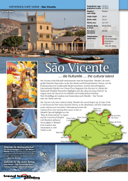
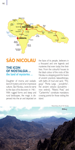
Kapverden Cape Verde Entdecken Sie die Kapverden mit einer Segelyacht oder Katamaran Discover Cape Verde Islands with a sailing yacht or catamaran Dufour Gib Sea 41 Dufour 455 Dufour 500 & Dufour 560 Cats von 41–48’ www.trend-travel-yachting.com … seit 2005 auf den Kapverden … on Cape Verde Islands since 2005 Kapverden … Cape Verde … … ein Traum, für Segler, die Ursprünglichkeit suchen … a dream for sailors, who are sarching for nativeness Warum Segeln auf den Kapverden? Why sailing Cape Verde? Die Kapverden sind ein Ganzjahres-Segelrevier ohne Hurrikans! Im Sommer sind die Winde eher moderat mit 2–4 Bft. Wer es also weniger windreich mag, sollte im Sommer auf den Kapverden segeln. Buchen Sie rechtzeitig, da im Sommer nur ein Teil unserer Flotte zur Verfügung steht. – immer guter Segelwind (keine Hurrikans) – ganzjährig angenehmes Klima – kilometerlange, noch fast unbeührte Strände – kristallklares Wasser, große Artenvielfalt an Fischen – offener Atlantik mit kurzen sowie anspruchsvollen Segeldistanzen – Fischen von der Yacht aus – ein tolles Erlebnis – lebensfrohe, freundliche und hilfsbereite Einwohner – eigene traditionelle Musik und Gesang – nur sechs Flugstunden ab Europa Cape Verde is a fantastic sailing area for experienced sailors all year round. During summer months winds are moderate with approx. 2–4 Bft. If you like to sail with more calm/moderate winds, we recommend to visite the islands in summer. But hurry up with booking as we have less yachts in our fleet in summertime! – steady sailing winds (no hurrican season) – pleasant climate all over the year – long and untouched beaches – crystal clear water and hugh variety of fishes – atlantic open water sailing with short and also challenging distances – fishing from the yacht – nice experience – friendly and helpful inhabitants – own traditional customs and music – flight only six hours from Europe Die Kapverden stehen lt. National Geographic Traveler Magazin auf der Liste der 21 besten und interessantesten Urlaubsregionen der Welt, ca. 800 sm südlich der Kanaren und 250 sm westlich von Senegal. Cape Verde Islands are on the list of the 21 best an most interesting tourist destinations in the world, 800 nm in the south of Canary Islands and 250 nm west of Senegal. Das Besondere an den Kapverden ist die Abwechslung und Unterschiedlichkeit von Natur und Kultur. Die Landschaft wechselt zwischen karg und tropisch grün, wüstenartig und gebirgig, menschenleer und lebendig. Der kreolische Kulturmix hat zur Folge, dass man sich einmal in Afrika und einmal in Brasilien oder auch in Portugal wähnt. Jede Insel ist anders von der Flora und Fauna – entdecken Sie Ihre Lieblingsinsel! Seit 2005 betreibt Trend Travel Yachting die Charterbasis mit eigenen Schiffen auf den Kapverden. Die Betreuung unserer Yachten erfolgt Kanaren/ durch Kai Brossmann und seinem Team. Sprachen auf dem Stützpunkt: Canary islands deutsch, englisch, französisch, italienisch, spanisch, portugiesisch. Ausgangspunkt für Ihren Segeltörn ist die Marina Mindelo – São Vicente (Seite 5). Willkommen auf den Kapverdischen Inseln – Bemvindo! The great variety and diversity of nature and culture are very particular for Cape Verde. The landscape changes from barren to tropical green, from desert to mountains, from deserted to vivid. Due to the Creole mixture of the culture you feel like in Africa, Brazil and Portugal. Each island has another flora and fauna – discover your favourite island! Since 2005 is Trend Travel Yachting with own yachts in Mindelo – Capo Verde. Service of our yachts with Kai Brossmann and his team. Languages at the base: English, French, Italian, Spanish, Portuguese. Starting point is Marina Mindelo – São Vicente – (more page 5). Welcome Cape Verde – Bemvindo! Schiffspreise, technische Daten, Grundrisse Yachtrates, layouts, specification www.trend-travel-yachting.com Herausgeber: Trend Travel & Yachting GmbH, Achenstraße 6, A-6322 Kirchbichl · Konzept: Klara Grassl · Design, Layout & Druck: Satz- und Druck-Team GmbH, 9020-Klagenfurt am Wörthersee · Fotos: Archiv, Trend Travel & Yachting, Brossmann, Billfish-Club CV, Hr. Lukesch, M. Schöbinger, Shutterstock · Nachdruck, auch auszugsweise, verboten! Druckfehler und Irrtümer vorbehalten. Kapverden/ Cape verde Nautische Bedingungen/nautical conditions NO-Passat/NE trade winds November–März/november–march 4–6 Bft. April–Oktober/april–october 3–4 Bft. Wassertemperaturen/water temperature ca./approx. 22–27 °C Lufttemperaturen/air temperature ca./approx. 24–29 °C 1 Woche (ca. 153 Seemeilen) 1 week (approx. 153 nautical miles) 1: Check-in São Vicente 2: Santo Antao (Tarrafal) 22 sm/nm 3: Santo Antao Landausflug 4: Santa Luzia 25 sm/nm 5: São Nicolau (Tarrafal) 40 sm/nm 6: São Nicolau Landausflug 7: Check-out São Vicente 66 sm/nm Kapverden/Cape verde · São Vicente Törnvorschläge 1 Woche (ca. 125 Seemeilen) 1 week (approx. 125 nautical miles) 1: Check-in São Vicente 2: Santa Luzia 25 sm/nm 3: São Nicolau (Tarrafal) 40 sm/nm 4: São Nicolau Landausflug 5: São Nicolau Carrical 20 sm/nm 6: Sal (Palmeira) 65 sm/nm SANTO ANTAO 7: Check-out Sal Tarrafal Itineraries Marina Mindelo 1 Woche/1 week 2 Wochen/2 weeks 3 Wochen/3 weeks Porto Novo Marina Mindelo 2 Wochen 20 nm (ca. 322 Seemeilen) 2 weeks (approx. 322 nautical miles) SANTA LUZIA São VICENTE 1: Check-in São Vicente 2: Santo Antao (Tarrafal) 22 sm/nm BRANCO 3: Brava (Nachtfahrt) 120 sm/nm 4: Brava Landausflug RASO 5:Fogo 10 sm/nm 25 nm 6: Fogo Landausflug 7: Santiago (Tarrafal) 50 sm/nm 8: Santiago Landausflug 9: São Nicolau 80 sm/nm 10:São Nicolau Landausflug 11:Santa Luzia 25 sm/nm 12:São Vicente 15 sm/nm 13: São Vicente Landausflug 14:Check-out São Vicente Palmeira SAL São NICOLAU Santa Maria Carrical Tarrafal 65 nm 20 nm 17 nm Inseln des B arlavento Isl and s of B arl avento Sal Rei BOAVISTA Santa Monica 2 Wochen (ca. 335 Seemeilen) 2 weeks (approx. 335 nautical miles) 1: Check-in São Vicente 2: Santa Luzia 15 sm/nm 3: São Nicolau (Tarrafal) 25 sm/nm 4: São Nicolau Landausflug 5:Boavista 95 sm/nm 6: Boavista Landausflug 7:Maio 45 sm/nm 8: Maio Landausflug 9: Santiago (Tarrafal) 35 sm/nm 10:Santiago Landausflug 11:São Nicolau (Carrical) 80 sm/nm 12:São Nicolau Landausflug 13:São Vicente 40 sm/nm 14:Check-out São Vicente 80 nm 125 nm 45 nm Inseln des S otavento Isl and s of Sot avento MAIO 45 nm Vila do Maio SANTIAGO Baia da Furna 3 Wochen (ca. 424 Seemeilen) 3 weeks (approx. 424 nautical miles) 1: Check-in São Vicente 2: Santo Antao (Tarrafal) 22 sm/nm 3: Brava (Nachfahrt) 120 sm/nm 4: Brava Landausflug 5:Fogo 10 sm/nm 6: Fogo Landausflug 7: Santiago (Tarrafal) 50 sm/nm 8: Santiago Landausflug 9:Maio 35 sm/nm 10:Maio Aufenthalt 11:Boavista 45 sm/nm 12:Boavista Aufenthalt 13:Sal 17 sm/nm 14:São Nicolau (Carrical) 65 sm/nm 15:São Nicolau (Tarrafal) 20 sm/nm 16:São Nicolau Aufenthalt 17:Santa Luzia 25 sm/nm 18:São Vicente 15 sm/nm Tarrafal BRAVA São Filipe 10 nm FOGO Praia 22 nm 45 nm Schiffspreise, technische Daten, Grundrisse Yachtrates, layouts, specification www.trend-travel-yachting.com Mindelo ist die heimliche Kulturhauptstadt des Archipels und eine knallige Mischung afrikanischer und südeuropäischer Kultur, voller Farben, Leben und Musik – „Morna“ ist überall … Markthalle, Fischmarkt, Cafés und Restaurants in kolonialem Ambiente bieten eine angenehme Gewöhnung an örtliche Verhältnisse, bevor es in den folgenden Tagen in z. T. unberührte Gegenden geht und die vielleicht auch kulturell deutlich afrikanischer geprägt sind. Die neue Marina Mindelo (die erste und einzige voll ausgerüstete Marina auf den Kapverden) liegt in unmittelbarer Nähe der malerischen Altstadt von Mindelo auf São Vicente. Das Serviceangebot von BoatCV entspricht in jeder Hinsicht den heute erforderlichen Ansprüchen (Yachtservice, Segelmacher sowie Zubehör-Handel, Tankstelle, Gas und Wasser). Mindelo is the hidden cultural capital of the archipelago and melting pot of African and South European culture – full of colors, life and music – “Morna” is everywhere … Market hall, fish market, cafes and restaurants come along in colonial ambiance helping familiarize, before leaving in the coming days to the quiet and sometimes unspoiled areas. New Marina Mindelo is the only marina on Cape Verde. BoatCV offers a lot of services e.g. sailmaker, fuel station, gas and water nearby the old town of Mindelo! Kapverden/Cape Verde · Trend Travel Yachting 5 Ponta do Sol Ribeira Grande Cruzinha da Garaca Kapverden/Cape Fontainhas Paul Losna Passagem Ribeira das Pombas Ribeira da Cruz Covo Krater 1.170 m Monte Maracos 1.767 m Curral das Vacas Geografische Lage/16°51’N geographical location24°58’W Kapverden/Cape verde · São Vicente Torre de Belem Hauptort/ main village Mindelo Länge/length 18 km Breite/width 22 km Fläche/area 227 km2 Höchster Berg/ h. mount Monte Verde Einwohner/ inhabitants 83.000 Ankerbuchten/ anchor bays 1 2 3 4 Baia d. Monte Trigo San Pedro Ponta Flamengos Salamansa Farol de Baia das Gatas Tope de Coroa 1.979 m 1 Tarrafal 2 Ponta de Peca … die Kulturelle … the cultural island São Vicente ist die kulturell interessanteste Insel der Kapverden. Mindelo, die zweitgrößte Stadt der Kapverden, ist für ihre Musik und Festivals bekannt. Morna, wie die Einheimischen ihre traditionelle Musik bezeichnen, wird Sie überall begleiten. Internationale Künstler wie Cèsaria Èvora begannen ihre Karriere in Lokalen der Hafenstadt Mindelo! Besondere Highlights sind das „Baia das Gatas Festival“ im August sowie der Karneval von Mindelo mit brasilianischem Einfluss! Neu! Direktflüge ab Lissabon und Amsterdam nach Mindelo – São Vicente oder mit TuiFly nach Sal. Riberinha San Pedro 1 Ponta Flamengos Eldorado für Hochseefischer! Für Hochseeangler gibt es den Blauen Marlin. Dieser schnelle Fisch kann über vier Meter lang werden und bis zu 700 kg wiegen. Hochsaison für diese Fische ist von März bis Oktober. 2 Tope da Caixa 535 m Madeiral Praia Do Matadouro Pont Sul Blue Marlin – High Season Big Game Fishing & Sailing – March till October San Pedro Trend Travel Yachting · Kapverden/Cape Verde Santo Antao … die Bergige … green and pleasant Fontainhas Santo Antao with its impressive mountain ranges is very popular for sailors, who want to hike and explore. Fissured summits and sharp ridges alternate with green pine and spruce forests! Go to the north to Paul with an Aluguer (collective taxi) The most important agricultural products like bananas, mangos, sweet corn or sugarcane get cultivated in this fertile valley. You can also visit a grogue distillery in Cha de Joao Vaz. Tarrafal Calhau Pico de Vento 437 m Geografische Lage/17°04’N geographical location25°10’W Eldorado for Big Game fishing 6 Ponta Caes dos Fortes Porto Novo Santo Antao mit seinen eindrucksvollen Gebirgslandschaften ist bei vielen Seglern beliebt zum Wandern und Entdecken. Zerklüftete Gipfel und scharfkantige Grate wechseln sich mit Fichten und Kieferwäldern ab! Fahren Sie mit dem Aluguer (Sammeltaxi) nach Paul im Norden der Insel. Viele landwirtschaftlich wichtige Produkte wie Maniok, Bananen, Mangos, Mais und Zuckerrohr werden im fruchtbaren Tal angebaut. Eine GrogueSchnapsbrennerei in Cha de Joao Vaz kann ebenso besichtigt werden. São Vicente São Vicente is the most cultural island. Mindelo the second largest city of Cape Verde is well known for their music festivals! Morna, as the inhabitants call their traditional music will join you everywhere. International artists like Ponta Joao Césaria Évora were starting their career in bars in d’Evora Mindelo! Special highlights are the Salamansa 3 “Baia de Gatas festival” in August 4 Farol de Baia and the Carnival of Mindelo Ponta Ladra Porto Grande Mindelo das Gatas with Brasilian influence! Cachorro Praia do Norte Direct flights to Mindelo Monte Verde from Lissabon and 750 m Amsterdam or with TuiFly to Sal. 3 verde · Santo Antao Hauptort/ main village Pt. Novo Länge/length 40 km Breite/width 20 km Fläche/area 779 km2 Höchster Berg/ h. mount Tope de Coroa Einwohner/ inhabitants 47.000 Ankerbuchten/ anchor bays 1 Baia d. Monte Trigo 2 Tarrafal 3 Porto Novo Fahrt mit dem Aluguer Kapverden/Cape Verde · Trend Travel Yachting 7 Kapverden/Cape verde · Santa Luzia Kapverden/Cape verde · São Nicolau Santa Luzia Santa Luzia Monte Orande 397 m 1 Baia de Praia Ponta de Creoulo Unbewohnt, Naturschutzgebiet! Uninhabitated, nature reserve! Santa Luzia (Naturschutzgebiet) bietet guten Schutz vor dem Wellengang, der aus NO wehenden Passatwinde. Außer von wenigen Fischerbooten wird die nur zeitweise im Sommer bewohnte Inselgruppe St. Luzia, Branco und Razo von Ruhesuchenden Sportbooten und Yachten angelaufen. Zahlreiche Delfinarten ziehen häufig an diesen Inseln vorbei. Über die Wintermonate bis ins Frühjahr kommen zudem Buckelwale zur Paarung in die Gegend des Archipels. Der kilometerlange feine Sandstrand in Baia de Praia lockt zum Baden, Schnorchelbegeisterte können die farbenfrohen tropischen Fische wie den grün-gelb-schimmernden, westafrikanischen Kaiserfisch beobachten. Meeresschildkröten können Sie über die Sommermonate sehen. Ponta de Creoulo Santa Luzia (nature reserve) offers good protection from the waves of the NE-trade winds. The islands are inhabitated just in summer and Branco so sailors can enjoy a real Robinson Crusoe-feeling. Different species of dolphins often pass by these islands. In winter Ponta Delgada and springtime humpback whales come along for mating. The very long white beach on Baia de Praia invites for swimming and snorkeling. You will see lots of different Razo colorful tropical fish like the greenyellow shining westafrican angel fisch Ponta da Cruz and in summer you can see seaturtles. Praia de Roque Geografische Lage/16°45’N geographical location24°44’W Länge/length 8,6 km Breite/width 4,3 km Fläche/area 34 km2 Höchster Berg/ h. mount Monte Orande Ankerbucht/ anchor bay 1 Baia de Praia São Nicolau … die ursprüngliche … the original island São Nicolau ist eine der nördlichen Inseln zwischen São Vicente und Sal. Die Einwohner leben vom Fischfang, der in der örtlichen Fischfabrik gleich zu Konserven verarbeitet wird. Rund um São Nicolao Ribeira Funda ist ein fischreiches Meeresbecken mit Langusten und Ribeira da Prata Thunfisch. Die Insel teilt sich in zwei Bereiche auf. Praia Branca Der Westteil ist sehr fruchtbar und bis in die höchsten Monte Gordo Lagen wird Feldbau betrieben. Es gedeihen vor allem Ribeira 1312 m Brava Bohnen und Mais, aber auch Orangen- und Papayabäume. Besuchen Sie den Parque Natural von Monte Ponta de 1 Gordo. Der Osten der Insel ist sehr trocken, die Portinho Küsten sind meist steil mit vereinzelten schwarzen 2 5 Preguica Stränden wie Carrical. Pt. do Tarrafal Morro Bras Belem São Nicolau is one of the northern islands between São Vicente and Sal. The inhabitants live from fishing with a fish factory. The sea basin 3 Baia de Luis around São Nicolau is rich of fish like spiny lobster and tuna. The 4 islands splits up in two parts. The western part is very fertile till higher levels. Beans, sweetcorn but also orange and papaya trees are growing there. Curral, Fidalgo Visit the Parque Natural of Monte Gordo. The eastern part of São Nicolau is very dry with steep coasts and black beaches like Carrical are rare. Baia do Carrical Fünf Arten von Meeresschildkröten gibt es um die kapverdischen Inseln. Nur zur Eiablage kommen die Tiere von Ende Mai bis Oktober an Land. Genießen Sie das Robinson-Feeling auf Santa Luzia! Enjoy the Robinson-Feeling of Santa Luzia! 8 Trend Travel Yachting · Kapverden/Cape Verde Five species of sea turtles live in the waters of Cape Verde Islands. These animals come to lay their eggs from late May to October. 6 Baia do Carrical Geografische Lage/16°37’N geographical location24°16’W Hauptort/ main village Rib. Brava Länge/length 20 km Breite/width 45 km Fläche/area 338 km2 Höchster Berg/ h. mount Monte Gordo Einwohner/ inhabitants ca./approx. 12.700 Ankerbuchten/ anchor bays Ribeira Grande Baia de Praia Juncalinho 1 2 3 4 5 6 Ponta de Portinho Pt. do Tarrafal Baia de Luis Curral Preguica Baia do Carrical Ponta de Vaca Kapverden/Cape verde · Brava Brava Porto da Faja Vila Nova Sintra Lima Doce Monte Fontainhas 976 m Cachaco 2 Tantum Porto dos Ferreios Brava ist die kleinste bewohnte Insel der Kapverden und wird auch Blumeninsel genannt. Da die Insel sehr hoch ist, ist diese fast ständig von Passatwolken umgeben. Dank dieses feuchten, fruchtbaren Klimas gedeihen wunderschöne Pflanzen wie Hibiskus und Oleander. Eine Fahrt in das höher gelegene Dorf Vila Nova Sintra ist empfehlenswert. Der Abstieg kann auch zu Fuß über die Straße oder alte Pfade erfolgen. Die Temperaturen auf Brava sind angenehm zum Wandern und die Sicht ist teilweise bis zur Nachbarinsel Fogo gegeben. Brava is the smallest inhabitated island and it‘s also called the flower island. Because the island is very high it is nearly all the year covered by trade clouds. This damp and fertile climate is ideal for hibiscus and oleanders to bloom. We recommend to go to the higher located village Vila Nova Sintra with Aluguer (collective taxi) The descent can also be done by foot on the street or the old path/trail. The temperatures on Brava are pleasant for hiking and sometimes you also have a great view to the neighbor island Fogo. Cova de Mar Ponta Nho Martinho Geografische Lage/14°51’N geographical location24°42’W Hauptort/ main village Nova Sintra Länge/length 11 km Breite/width 9 km Fläche/area 67 km2 Höchster Berg/ h. mount Monte Fontainhas Einwohner/ inhabitants ca./approx. 6.800 Ankerbuchten/ anchor bays 1 Porto da Faja 2 Porto dos Ferreios 3 Baia da Furna Baia da Furna Fogo, die Vulkaninsel ist mit dem Pico de Fogo die höchste Insel der Kap verden. Der aus 4.000 m Meerestiefe aufsteigende fast symmetrische Kegel erreicht über Wasser noch weitere 2.829 m. Am Fuße des großen Vulkan kegels befindet sich eine Caldeira (Cha das Caldeiras), welche einen Durchmesser von ca. 8 Kilometer hat. 1995 brach in dieser Caldeira ein kleiner Vulkan (Pico Pequeno) aus und verwüstete die seit 100 Jahren angelegten Weingärten. Hier wurde der berühmte Fogo-Wein angebaut und dieser war die Grundlage der beiden Dörfer Portela und Bangaeira. Nach diesem Ausbruch wurde diese Weinkooperative wieder aufgebaut und man errichtete 2014 ein Besucherzentrum, das mithilfe deutscher Entwicklungshilfe gebaut wurde. Leider ist am 23.11.2014 der Pico Pequeno wieder ausgebrochen. Dieser Ausbruch war gewaltiger als der von 1995 und vernichtete durch Lavaströme die beiden Dörfer in der Caldera. Die Existenzgrundlage von ca. 1.000 Menschen wurde durch den Ausbruch zerstört und es ist zurzeit nicht absehbar, wie es in Fogo weitergehen wird. Wir werden Sie weiter informieren. Fogo … die Vulkaninsel … the vulcano island Baia do Monte Vermelho 4 Atalaia Ponta da Salina Ponta da Garca Curral Grande 5 Mosteiros Corvo Cha das Caldeiras Monte Contador 965 m Pico de Fogo 2.829 m 2 Cavaleiros 1 São Filipe Nossa Senora 3 Ponta Furada Cova Figuera Achada Furna Praia da Casinha Ribeira da Faja Monte Verde 315 m Geografische Lage/14°57’N geographical location24°23’W Segeln auf den Kapverden ist offenes Atlantiksegeln oder auch anspruchsvolle Segeldistanzen Sailing in Cape Verde Islands is open atlantic sailing with short but also ambitious sailing distances Trend Travel Yachting · Kapverden/Cape Verde Baia da Furna 1 Cova Joana … die Blumeninsel … the flower island 10 Kapverden/Cape verde · Fogo 3 Monte Pesqueiro Porto da Faja Baia da Furna Fogo, the volcano island with the Pico de Fogo is the highest island of the Cape Verdean archipelago. The almost symmetric volcanic cone arises from 4000 meters depth and crests further 2829 meters above sea level. At the foot of the cone there is the Caldeira (Cha das Caldeiras) located, which has a diameter of approx. 8 km. In 1995 the smaller Pico Pequeno erupted directly in the Caldeira and devastated the 100 years old vineyards, where the famous Fogo-wine was cultivated. The vineyards were the livelihood of the two villages Portela and Bangaeira. After this volcanic eruption the vineyards were rebuilt and in 2014 a visitor center was established with development aid from Germany. Unfortunately on 23.11.2014 the Pico Pequeno erupted again and this time the eruption was more massive than in 1995. Both villages in the Caldeira, Portela and Bangaeira, were destroyed from the lava. The livelihood of approx. 1000 people has been completely destroyed and currently it is not foreseeable how the situation will process on Fogo. We will keep you informed. Hauptort/ main village São Filipe Länge/length 26 km Breite/width 26 km Fläche/area 476 km2 Höchster Berg/ h. mount Pico de Fogo Einwohner/ inhabitants ca./approx. 37.400 Ankerbuchten/ anchor bays 1 2 3 4 5 São Filipe Cavaleiros Nossa Senora Moteiros Cha das Caldeiras Kapverden/Cape Verde · Trend Travel Yachting 11 Farol de Fiura Kapverden/Cape verde · Santiago Ponta de Casaca Monte Grande 403 m Buracona Sal … die Sonnige … the sunny island Tarrafal Palmeira 1 2 Geografische Lage/15°05’N geographical location23°37’W Santiago … die Fruchtbare … the fertile island Ponta Preta Santiago ist die größte Insel der Kapverden mit der Hauptstadt Praia, die sich im Süden der Insel befindet. Am intensivsten wird das Innere der Insel landwirtschaftlich an den hohen und langen Gebirgszügen genutzt. Besonders empfiehlt sich die Fahrt durch das Bergland zum höher gelegenen Ort Assomada. Mehrmals wöchentlich ist dort ein großer Bauernmarkt, der einen Überblick über viele selbst angebaute landestypische Produkte, aber auch Blechwaren, Geschirr etc. bietet. Die Ortschaft Serra ermöglicht eine atemberaubende Aussicht auf die darunterliegenden Täler. Die Bucht von Tarrafal im Norden von Santiago ist selbst bei Einheimischen sehr beliebt. Ein oasenhafter, weißer Sandstrand mit Kokospalmen lädt zum Baden ein. Auch in Tarrafal gibt es eine Markthalle, wo Obst, Gemüse, Textilien mit Stickereien sowie Flecht- und Töpferwaren angeboten werden. Täglich landen auch Fischer mit ihren bunt bemalten Ruderbooten mit bis zu 2 m großen Thunfischen an, welche gleich von deren Frauen verarbeitet werden. Tarrafal Ponta Furna 1 Cha de Ribeira da Prata Praia Länge/length 55 km Breite/width 27 km Fläche/area 991 km2 Porto 3 Rincao ca./approx. 236.600 Sal bietet perfekte Voraussetzungen für einen Strandurlaub. Viele internationale Flüge landen auf Sal und die Ortschaft Santa Maria im Süden der Insel wird am öftesten für den Hotelurlaub ausgewählt, da sich dort viele 4- und 5-Sterne-Hotels am weißen Sandstrand befinden. Sal ist auch ein Spot für Surf- und Tauchbegeisterte. Kristallklares Wasser, lange Sandstrände und beständige Winde bieten perfekte Bedingungen, um noch einige Tage vor oder nach ihrem Segeltörn auf Sal zu verbringen. Ab Santa Maria werden z. B. auch interessante Quad-BuggyTouren durch die Dünenlandschaften über Ponta Preta bis nach Murdeira angeboten. In Palmeira, im Westen der Insel, befindet sich eine geschützte und weite Hafenbucht. Im ursprünglichen Fischerdorf mit traditionellen kleinen Restaurants werden frische Fischgerichte serviert. Tarrafal Ribeira da Barca Porto Rincao Baia do Inferno Cidade Velha Praia Porto de Pedra Badejo Porto de 7 Pedra Badejo Assomada Praia Baixo 4 Pico do Antonio Baia do Inferno 1.394 m S. Domingos Ponta da Cinta Branca Gouvelia 5 Cidade Velha Ribeira Chiqueiro 6 Ponta Inglesa Praia Santiago is the biggest island. The capital is Praia in the south. The high and long mountain ranges inside the island are used intensively for agriculture. We recommend to make a cruise through the mountains to the village of Assomada. About twice a week there is a big market, where you can get an idea about typical Cape Verdian products. The village Serra offers a breath taking view to the underlying valleys. The bay of Tarrafal with its beautiful white sandy beach with coconut palms invites you to swim and relax. In Tarrafal there is a markethall where fruits, vegetables, textiles, embroideries and potteries are offered. Daily fishermen are coming back to Tarrafal with caught tunas (up to 2 meters) Assomada 12 3 Einwohner/ inhabitants Ribeira da Barca Trend Travel Yachting · Kapverden/Cape Verde Ponta da Fragata Baia do Algodoeiro Pico da Antonia Serra 2 Ponta do Morrinho Vermelho Höchster Berg/ h. mount 1 Ankerbuchten/ anchor bays 2 3 Porto Formosa 4 5 Mangue de 6 Sete Ribeiras 7 Porto de Pedra Lume Espargos Baia da Murdeira Hauptort/ main village 4 Prequica Sal offers perfect conditions for beach holidays. Most of the international flights arrive on island Sal and the village of Santa Maria in the south is mostly chosen for beach holidays because of the great number of 4–5 star-hotels with international standard at the beautiful white beach. Sal is also a hotspot for surfing and diving – crystal clear water, long sandy beaches and steady winds offer perfect conditions to spend some days in Sal before or after your cruise. From Santa Maria interesting quad- and buggytours are offered through the dunes to Ponta Preta and Murdeira. In Palmeira at the west side of the island you will find a wide and protected bay with a traditional fishing village. In the small restaurants you can enjoy fresh fish dishes. Santa Maria Geografische Lage/16°44’N geographical location22°56’W Hauptort/ main village Santa Maria Länge/length 30 km Breite/width 12 km Fläche/area 216 km2 Höchster Berg/ h. mount Monte Grande Einwohner/ inhabitants ca./approx. 14.800 Ankerbuchten/ anchor bays 1 2 3 4 Palmeira Baia da Murdeira Santa Maria Porto de Pedra Lume Kapverden/Cape Verde · Trend Travel Yachting 13 Ponta Cais Kapverden/Cape verde · Boavista Ponta Pipa Ponta Branca Kapverden/Cape verde · Maio Ponta Pedrenau Baia de Santana Cascabulho Morrinho Boavista San Antonio Pedro Vaz Calheta … die Gemütliche … the cozy island Monte Penoso 437 m Morro 1 Ponta do Sol Costa de Boa Esperança Ilhéu de 1 Sal Rei Sal Rei Ponta dos Flamengos Ribeira d. Joao Praia da Logoa Geografische Lage/15°13’N geographical location23°10’W Espingueira Ponta Rodrigo Joao Galego Norte Rabil Praia da Chave Pilao Cao Figueira da Horta Vila do Maio Ponta das Casas Velhas Maio … die Einsame … the lonesome island Cabeco dos Tarafes Pico d’Estancia 387 m Hauptort/ main village Vila do Maio Länge/length 26 km Breite/width 17 km Fläche/area 269 km2 Höchster Berg/ h. mount Monte Penoso Einwohner/ inhabitants ca./approx. 6.800 Ankerbuchten/ 1 Vila do Maio Povoacao Velha Santa Monica Ponta Pesqueiro 2 Boavista ist eine der flachen Ostinseln mit vielen Sanddünen. Die Ortschaft Sal Rei liegt an der Nordseite der Insel, von der sich kilometerlange, breite Strände bis nach Praia da Chave erstrecken. Rund um die vorgelagerte Insel Ilhéu de Sal Rai befindet sich eines der beliebtesten Tauch- und Schnorchelreviere mit ruhigem Wasser und reicher Flora und Fauna. Allein nördlich von Sal Rei in der Bucht Esperança liegen mehr als 50 Wracks aus über fünf Jahrhunderten. Boavista is one of the flat islands in the east with lots of dunes. The village Sal Rei is located in the west and offers endless beaches till Praia da Chave. Around the island Ilhéu de Sal is a famous diving and snorkeling spot with calm water and rich flora and fauna. More than 50 wrecks (from over 5 centuries) are situated in the north of Sal Rei in the bay of Esperança. Wüste 14 Trend Travel Yachting · Kapverden/Cape Verde Sal Rei Geografische Lage/16°05’N geographical location22°45’W Hauptort/ main village Sal Rei Länge/length 31 km Breite/width 29 km Fläche/area 620 km2 Höchster Berg/ h. mount Pico d’Estancia Einwohner/ inhabitants ca./approx. 4.200 Ankerbuchten/ anchor bays 1 Sal Rei 2 Santa Monica Die Insel Maio wurde erst vier Jahre nach Boavista entdeckt. Anfangs wurde die Insel nur als Weideland für Ziegen und Esel genutzt, später brachte die Salzgewinnung aus den noch heute sichtbaren Salinen neuen, bescheidenen Reichtum. Auf Mao regnet es praktisch nie, da sich die Passatwolken durch die geringe Höhe nicht entladen können. Eine Inselrundfahrt macht deutlich, dass sich die Bewohner mit der Aufforstung von sonst fremden Baumarten wie Akazien oder dem Gemüseanbau sehr bemühen. Als lokale Spezialität wird einheimischer Käse angeboten. Der Besuch der Insel Maio ist aber grundsätzlich mit viel Ruhe und Beschaulichkeit verbunden. Vielleicht sehen Sie einige Schildkröten, die an den unberührten Stränden zur Eiablage an Land kommen. The island Maio got discovered 4 years after Boavista. At the beginning the island was only used as pastureland for goats and donkeys. Later the island got modest wealth with salt production from the still visible salines. It never rains here because the island is too flat to collect the trade clouds. The inhabitants try all to reforest trees like acacia…and cultivate vegetables. They offer cheese as local speciality. Visiting Maio means quietness and tranquility. Maybe you can see some turtles coming ashore of one of the untouched beaches to lay their eggs Sal Rei Marktplatz Kapverden/Cape Verde · Trend Travel Yachting 15 Bemvindo Willkommen – Welcome Segeln, entdecken ohne Stress Sailing, living without stress Mehr Infos? Aktueller nautischer Törnführer Cruising guide Aktueller nautischer Törnführer von Kai Brossmann und André Mégroz. 240 Seiten in A5-Format, gebunden – jährlich aktualisiert! Infos zu nautischen Bedingungen, GPS-Wegpunkte, Beschreibungen aller Inseln und Häfen/Ankerplätze, Törnvorschläge, Einkaufs-/ Versorgungstipps sowie Wissenswertes über Land und Leute. Annual updated nautical cruising guide from Kai Brossmann and André Mégroz. You will find all details about nautical conditions, GPS waypoints, description concerning the islands, harbours/anchorages, itineraries, shopping advices and interesting facts about the country and the population! Ebenso als „Light“-Version „Ankerplätze und Häfen“ (ca. 60 Seiten) in Deutsch, Englisch, Französisch und Italienisch erhältlich. sowie weitere Revier-CD, Kriolu-Sprachführer, Culinaria etc. auf Anfrage. Also available as “light” version with 60 pages in German, English, French and Italian as well as further CD’s about the sailing area, Crioluphrasebook/audio, Culinaria etc.! Bezugsquelle/supplier: [email protected] Yachtcharter · Kauf-Charter · Yachthandel Neu-/Gebrauchtyachten · Ausstellungshalle Familien-Unternehmen seit 1987 A-6322 Kirchbichl/Tirol, Achenstraße 6 Tel. +43(0)5332/74291 Fax +43(0)5332/74293 Nulltarif aus D: 0800/8573281 [email protected] www.trend-travel-yachting.com
Download