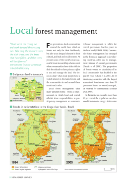
Time Series Analysis of Earth
Observation Data for Land
Degradation in Amazonia
Gilberto Câmara
National Institute for Space Research (INPE), Brazil
With many thanks to…
Merret Buurman
Ricardo Cartaxo
Victor Maus
Karine Ferreira
Gilberto Ribeiro
Lúbia Vinhas
Alber Sanchez
Dalton Valeriano
How much degradation has happened?
Degradation: loss of forest cover by logging and fire
Degradation causes GHG emission and biodiversity loss
Not all degradation leads to clear-cut areas
source: Ima Vieira
What changes with big EO data?
graphics: Geoscience Australia
What are we looking for in big EO data?
Is free data download our answer?
Currently, users download one snapshot at a time
Data Access Hitting a Wall
How do you download a petabyte?
You don’t! Move the software to the archive
Where we want to get to
Remote visualization and
method development
Big data EO
management and
analysis
40 years of Earth Observation data of land change
accessible for analysis and modelling.
Analysis on multidimensional ST arrays
t
y
X
g = f (<x,y,t> [a1, ….an])
Array databases: all data from a sensor
put together in a single array
t
y
result = analysis_function (points in space-time )
X
Time series of remote sensing satellite data
Forest
Pasture
Agric
Área 1
Forest
Área 2
Forest
Agriculture
Área 3
“Remote sensing time series with adequate resolution
provide data for describing landscape dynamics”
source: Victor Maus (INPE, IFGI)
Space first, time later or time first, space later?
Space first: classify
images separately
Compare results in time
Time first: classify
time series separately
Join results to get maps
Space first can lead to inconsistent land trajectories
MODIS land cover: unrealistic forest gains and losses
Data sources: INPE, NASA. Analysis by M. Buurman
Land trajectories
Forest
Área 1
Área 2
Pasture
Agric
Forest
Forest
Agriculture
Área 3
“The transformations of land cover due to actions of
land use”
graphics: Victor Maus (INPE, IFGI)
Land trajectories
Forest
Single cropping
Double cropping
2001
2006
2013
Time series of remote sensing satellite data
Hypothesis: large-scale fires that cause degradation are
measurable by MODIS remote sensing time series
source: Victor Maus (INPE, IFGI)
Land trajectories: forest degradation
EVI Time Series
2007
2007
2009
2009
Land trajectories: forest degradation
EVI Time Series
2007
2009
PRODES
2007
2008
Large-scale fire in Porto dos Gauchos (2008)
Large-scale fire and PRODES data
LANDSAT image 2008 and PRODES 2011
Large-scale fire in Porto dos Gauchos (2011)
Hypotesis: land patterns have distinct shapes
Forest
Pasture
Agric
Área 1
Forest
Área 2
Forest
Agriculture
Área 3
source: Victor Maus (INPE, IFGI)
Time series mining: pattern matching
Finding subsequences in a time series
High computational complexity
Patterns are idealized, data is noisy
Esling & Agon (2012)
What is similarity?
resemblance, likeness, sameness, comparability,
correspondence, analogy, parallel, equivalence;
adapted from Keogh (2006)
Dynamic Time Warping (DTW)
Euclidean
DTW
Jan
Feb
Sep
May
Sep
Similarity between patterns even with different phase
… and/or patterns with different lengths
May
Dynamic Time Warping: pattern matching
Arvor et al (2012), Eamon Keogh
DTW “warps” the time axis: nonlinear matching
Open boundary Dynamic Time Warping
Single cropping
~1 year
does not require two time series to be of the same length
considers the agricultural calendar
Accumulated cost matrix
Three possible alignments of the pattern U within the longterm time series V
Maus et al. (2015)
Porto dos Gaúchos, MT
Maus et al. (2015)
MODIS x Time-weighted DTW
Producer's accuracy: fraction of correctly classified
pixels compared to all pixels of that ground truth class
User's accuracy (reliability): fraction of correctly
classified pixels of a class compared to all pixels
classified as being that class
On-going work: identify forest degradation from large-scale fires
for Amazonia from 2000-2015
On-going work: identify forest degradation from large-scale fires
for Amazonia from 2000-2015
On-going work: identify forest degradation from large-scale fires
for Amazonia from 2000-2015
Download