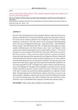
TBM tunnel under Serra do Mar range: The first Hard Rock
mechanized tunnel in Brazil
Marcos Hartwig, M.Sc.
GeoCompany, Barueri, Brazil, [email protected]
Renato Silva Araujo, M.Sc.
GeoCompany, Barueri, Brazil, [email protected]
Izabel Gomes Bastos, M.Sc.
GeoCompany, Barueri, Brazil, [email protected]
Prof. Dr. Roberto Kochen
Escola Politécnica da USP, São Paulo, Brazil, [email protected]
ABSTRACT: The Gastau Tunnel with 5,1 km in length and diameter of 6,2 m, was mined by the
first hard rock TBM in Brazil. It goes through Serra do Mar coastal range in the town of
Caraguatatuba, on the São Paulo State north coast. Its first 282,3m was excavated by NATM
method. Most of it was mined in a very hard, abrasive and low-fractured coarse-grained granitegneiss. Because of it were used up 1635 cutters during TBM operation, which represents 333 days,
resulting in an overall average production of 12,3 m/d. Despite Gastau tunnel represent itself the
deepest civil construction of Brazil, and Serra do Mar range is controlled by numerous geological
structures, challenges were related to localized underground water inflow, high strength and
abrasiveness of rock mass.
KEYWORDS: TBM hard rock, Serra do Mar range, São Paulo State north coast.
1
INTRODUCTION
The Gastau Tunnel is part of a 160 km gas
pipeline that is to link the natural gas treatment
unit in the town of Caraguatatuba (UTGCA), on
the São Paulo State north coast, to the innerstate town of Taubaté (Figure 1). The Gastau
Tunnel, with a route length of 5,1 km, external
diameter of 6,2 m, and a constant positive
gradient of 3 %, has been mostly mined in a
very hard, abrasive and low-fractured coarse-
grained granite-gneiss, by a WIRTH Double
Shield Tunnel Boring Machine (TBM) through
Serra do Mar coastal range. The first 282,3m of
the tunnel was excavated mostly in saprolite by
NATM method. At the end of the tunnel is
projected the construction of vertical shafts for
the passage of pipelines to the surface. The
maximum overburden is about 670m. The aim
of this paper is to describe the main
construction aspects of the first TBM hard rock
Tunnel in Brazil.
Figure 1. Location of Gastau Tunnel (dashed line), São Paulo State north coast. Coordinate System UTM/SAD69, Zona
23K. Source: HRC-CBERS-2B panchromatic high resolution image.
2
INVESTIGATION
Geological-geotechnical investigations are
divided in time between pre-construction and
sin-construction investigations. The first is
consisted of three types: direct investigation
represented by drills, indirect investigation
represented by geophysical survey, and in-situ
testing for geotechnical site characterization,
represented by hydraulic fracturing and
hydraulic conductivity tests. The last consists of
geophysical investigations in advance and
probe-drills.
Figure 2 shows the resistivity profile and
drills location along headtrace. As one can see
drills are concentrated at the beginning and at
the end of the tunnel, whereas low values of
resistivity, which means poor rock mass quality
or soil, occur around stations 0+250, 1+000,
1+400, 2+200, 2+500, 3+000, 3+600, 3+900,
4+250 and 4+900m. Despite of it only around
stations 0+250, 2+500, 3+900 and 4+900 m
where found intermediate to poor rock mass
quality (RMR III and IV). Few of these
“anomalies” were related to dikes. Because of
overburden (Serra do Mar escarpment and
Atlantic high Plateau), deep resistivity survey
(penetration up to 500m) was used from station
3+000 m to the end of the excavation. The
results did not show significant differences
from the profile of Figure 2 neither increased
the underground knowledge so far.
In-situ testing for geotechnical site
characterization included hydraulic fracturing
and hydraulic conductivity tests, both
accomplished in the shafts area, at station
4+900 m. The hydraulic fracturing were tested
from the depth of 138,7 to 149,2m. The
orientation of the maximum horizontal stress
(SHmax) is in the range of N-NNE. The ratio of
horizontal to vertical stress (k0), extrapolated to
the depth of 540 m is equal to 1,5. The
hydraulic conductivity was determined in ten
fractured intervals of three meters each, from
the depth of 26 to 451 m. The hydraulic
conductivity test showed low-permeability
fractures (Kmax=10-6cm/s) possibly related to
high confined stress.
At last, sin-construction investigations
consist of electrical and seismic methods,
besides of probe-drills. Electrical method is
sensible to underground water, and can reach up
to 20 m ahead of excavation. By the other hand,
seismic method are sensible to poor rock mass
and geological contacts, and can reach up to
100 m ahead of excavation. For the Gastau
Tunnel seismic method showed to be more
efficient and was combined to probe-drills.
3
HEADTRACE
GEOMECHANICS
GEOLOGY
AND
The Serra do Mar range is one of the most
remarkable
physiographic
features
of
southeastern Brazilian coast. This feature with
summits over 2.200 m.a.s.l, follow Precambrian
basement structures which is constituted of
metassedimentary rocks intruded by several
generations of granitoid rocks, included in the
Ribeira folded belt [1]. After a long period of
tectonic
quiescence,
the
present-day
southeastern Brazilian coast was subjected to an
important process of tectonic reactivation,
manifested since Jurassic times which
culminated with opening of South Atlantic
Ocean [2].
The geology along the headtrace alignment
includes
four
main
lithotypes,
from
Precambrian to Cenozoic ages: course grained
granite-gneiss and granodiorite-gneiss, milonite
and basic to alkaline dikes (Figures 3 and 4).
The Precambrian Ribeirao do Ouro Fault Zone,
at the foot of the Serra do Mar escarpment, is
composed mostly of a mixture of fresh and
weathered granitoids, milonite, breccia and
enclaves of metamorphic rocks.
The rock mass classification was based on
[3]. The RMR along headtrace showed up that
about 90% of the tunnel exhibits rock class I
and II. Mechanical properties for intact
metamorphic and granitic rocks comprise
uniaxial compressive strength and Cerchar
abrasivity within the range of 86-143 MPa and
3,9-5,8, respectively.
Figure 2. Geophysical cross-section and drills along
headtrace. Hot colors indicate high values of resistivity,
whereas cold colors indicate low values.
A
B
C
Figure 3. Geological cross-section along headtrace
D
Figure 4. Close-up of main lithotypes along headtrace: A
– granite-gneiss; B – granodiorite-gneiss; C – Dike, pk
0+832m; D – milonite
E
F
Figure 4. Close-up of main lithotypes along headtrace: E
– contact between milonite and dike, pk 2+368m
(Ribeirão do Ouro Fault Zone); and F – pegmatite vein,
pk 1+147m
Underground water inflow was more
significant at stations 2+368, 2+913, 2+967,
3+510, 3+927 and from 4+400 to 4+475m,
where it reached the maximum accumulated
value of 720m3/h (Figure 4). Most of
underground water inflows were associated to
dikes. The most important record occurred at
station 2+368m, where it reached about
252m3/h. In this region was mapped the largest
dike along headtrace. It is intruded in the
Ribeirao do Ouro Fault Zone.
4
CONSTRUCTION ASPECTS
First TBM excavation took place on
11/11/2009. Productive excavation started on
08/01/2010 at Sta. 0+493,1 (Figure 5). On
26/01/2011 at Sta. 5+198,2 the Tunnel was
completed. During this time (384 days),
excavation took place during 333 days (86%),
resulting in an overall average of 12,3 m/d. The
maximum advance was 30,78 m/day, 145,7
m/week and 501,28 m/month. The highest
production rates were achieved in March,
during the excavation of granodiorite-gneiss.
The total average thrust, based on 46 discs,
was 12.900 kN. The average torque was
2.300kNm. It was used up 1635 cutters during
TBM operation.
During the construction of the Gastau
Tunnel, excavation was performed without
accidents that would need work interruption,
therefore guarantying an adequate underground
construction for the many geologicalgeotechnical challenges imposed by the project.
5
CONCLUDING REMARKS
5163,20
5071,20
The Gastau Tunnel was mined by the first TBM
hard rock in Brazil and represents a remarkable
reference for designers and future projects. It
goes through Serra do Mar coastal range in the
town of Caraguatatuba, on the São Paulo State
north coast. Most of it was mined in a very
hard, abrasive and low-fractured coarse-grained
granite-gneiss. Because of it were used up 1635
cutters during TBM operation, which
represented 333 days, resulting in an overall
average production of 12,3 m/d. Despite Gastau
tunnel represent itself the deepest civil
construction of Brazil, and Serra do Mar range
is controlled by numerous geological structures,
challenges
were
related
to
localized
underground water inflow (up to 720m3/h), in
general associated to dikes, high strength and
abrasiveness of rock mass.
4959,40
4853,37
4777,00
4668,54
4570,00
4521,27
4492,08
4469,16
4377,06
4265,97
4173,15
4070,40
Flow (m³/min)
3975,93
REFERENCES
3866,91
3768,30
3650,61
3544,98
3477,69
3414,09
3257,85
3178,68
3120,54
3120,54
3120,54
3056,01
2970,33
2877,72
2569,11
0
2
4
6
8
10
12
14
2368,53
Figure 5. Underground water flow for Gastau Tunnel.
[1] Almeida, F.F.M. (1976). The system of continental
rifts bordering the Santos Basin, Brazil. Anais da
Academia Brasileira de Ciências, 48 (suplemento). p.
15-26
[2] Bieniawski, Z.T. (1989). Engineering rock mass
classification: a complete manual for engineers and
geologist in mining, civil, and petroleum engineering.
New York: John Wiley, 251p.
[3] Hasui, Y.; Carneiro, C.D.R.; Coimbra, A.M. (1975).
The Ribeira Folded Belt. Revista Brasileira de
Geociências, v.5, p. 257-266.
[4] Elsner, P.; Vidal, C. (2012) Experiences From the
Hard Rock TBM Tunnel Drive in Brazil. 3°
Congresso Brasileiro de Túneis e Estruturas
Subterrâneas.
[5] Kanji, M.; Teixeira, R.; Cezar, M.; Elsner, P. (2012)
Geologia do Túnel GASTAU e sua Influência na
Escavação por TBM. 3° Congresso Brasileiro de
Túneis e Estruturas Subterrâneas.
[6] Manzano, A.; Mattos, T.; Assis, S.; Oliveira, W.
(2012) O Desafio do Parque Estadual da Serra do Mar
- Gasoduto GASTAU. 3° Congresso Brasileiro de
Túneis e Estruturas Subterrâneas; Seminário
Internacional "South American Tunnelling - SAT."
[7] Filho, C.; Neto, J.; Ansaloni, R. (2012) O Túnel do
Gasoduto Caraguatatuba - Taubaté e a Minimização
dos Impactos Sobre o Ambiente Protegido da Serra
do Mar. 3° Congresso Brasileiro de Túneis e
Estruturas Subterrâneas.
Download