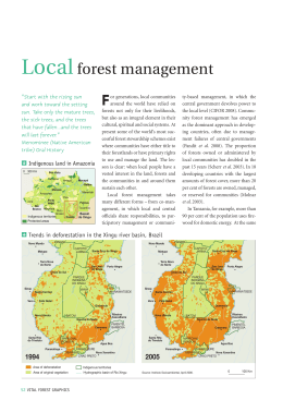
Please consider the environment before printing | PDF version
A tale of two maps: Brazilian state won’t use new atlas to close Cerrado
deforestation loophole
Brendan Borrell
April 13, 2015
This article was produced under Mongabay.org's Special Reporting
Initiatives (SRI) program and can be re-published on your web site or in
your magazine, newsletter, or newspaper under these terms.
A remnant tree looms over the landscape in southwestern Tocantins state. Photo credit: Brendan Borrell
Farmers in north-central Brazil, where the savanna meets the Amazon rainforest, are clearing land at an
unprecedented rate. The government hasn’t stopped the cutting, partly because it is using inaccurate, outdated
Do you need professional PDFs? Try PDFmyURL fully for free!
unprecedented rate. The government hasn’t stopped the cutting, partly because it is using inaccurate, outdated
maps that hugely underestimate the extent of its endangered dry forests. State regulators in Tocantins have
continued using the old maps, even after commissioning superior, detailed vegetation maps that could identify
at-risk forest patches and help curb deforestation.
“Years from now when we are without water, they will regret it,” says Ricardo Haidar, a forest engineer based in
the city of Palmas. “The government paid for the study, but they are not using the data.”
Tocantins, Brazil’s newest state was named in 1988 after its shape which looks like a toucan’s beak with the tip
pointing north toward the Amazon River, some 400 miles away. Though the majority of the state is within the
biodiverse savanna known as the Cerrado, it has some of the region’s most extensive forests and forms a
critical transition zone that merges into Amazonia.
In December 2014, Kátia Abreu -- the Tocantins senator who environmentalists have called “Miss
Deforestation” and the “Chainsaw Queen” -- was named Brazil’s Minister of Agriculture, putting the state’s poor
environmental record in the national spotlight. All along the Belem-Brasilia Highway, one of the state’s major
north-south thoroughfares, locals have watched Tocantins’ forests being razed for soy and rice crops at a
stunning pace. Forests in this corner of the Cerrado shrank by 66 percent between 1977 and 2008, and they
will likely vanish completely in the next 25 years unless action is taken, says a 2013 study published in
Biotropica.
Do you need professional PDFs? Try PDFmyURL fully for free!
The 2008 outdated inaccurate vegetation map for the state of Tocantins. Map credit: Naturatins. Click to
enlarge.
Do you need professional PDFs? Try PDFmyURL fully for free!
The high resolution map of vegetation zones in Tocantins from 2012 doubled the amount of land area
previously classified as forest. This increase was largely due to the recognition of small patches of seasonally
dry forest, “Floresta Estacional,” which now account for 13.1 percent of the historic land cover. Map credit:
Ricardo Haidar et al. Click to enlarge.
Tocantins’ forests are supposed to merit special protection in Brazil. It is one of nine states that make up the
Legal Amazon, or “Amazônia Legal.” Under Brazil’s forest code, landowners here are required to preserve 80
percent of the forest areas on their property, including both rainforest and dry forest, along with 35 percent of
savanna areas.
Enforcement, however, is lax -- which is where those old, imprecise maps come into the picture. The state
environmental agency, Naturatins, authorizes cutting permits and penalizes landowners who clear more land
than is allowed under the federal Forest Code. But identifying forestland and enforcing cutting regulations
depends heavily on which maps you use.
Do you need professional PDFs? Try PDFmyURL fully for free!
depends heavily on which maps you use.
The old, low-resolution forest maps employed by Naturatins work like a weak magnifying glass. While they
show the bigger blocks of forest, the maps fail to show small patches of remnant forest. If those patches aren’t
identified, then no one needs a permit to cut them down or is penalized for doing so.
A marsh deer (Blastocerus dichotomus) grazes in a flooded rice field that was once forest. Photo credit:
Brendan Borrell
In 2008, Ricardo Haidar was recruited to remedy the situation. He began coordinating field teams to generate a
new World Bank-funded atlas for the Tocantins Department of Planning and Modernization of Public
Management. The team worked for three years, combining detailed satellite data and field studies to identify 20
different Tocantins plant communities. These vegetative zones included two types of rainforest that occur in the
Amazonian parts of Tocantins, along with eight types of seasonally dry forests found in the Cerrado biome.
Because the Cerrado includes so many dissimilar plant communities, and because many forests exist in small
patches missed by the old maps, Haidar created a detailed atlas with a resolution of 1:100,000 -- a scale ten
times more precise than existing state maps.
This new atlas, published in 2012, doubled the extent of the state’s forest zones from 12 percent to 25 percent.
This increase was largely due to the identification of thousands of tiny patches of dry forest, which Haidar says
represent 13 percent of the state’s historic land cover, rather than 2.6 percent as shown on the state map from
2008.
Do you need professional PDFs? Try PDFmyURL fully for free!
2008.
In theory, this increase should make a larger swath of the state off-limits to deforestation and farming. The new
atlas has not, however, been put to use by the environmental regulators at Naturatins. “I haven’t received the
map yet,” says Renato Piris da Silva, one of the agency’s natural resource inspectors. He is still using the old
one. “There are some political issues,” he admits, without going into specifics.
Ricardo Fava, the head of Naturatins, failed to respond to phone calls and emails for comment.
In an interview with Mongabay.com, Rodrigo Sabino Teixeira Borges, the director of Ecological-Economic
Zoning at the Department of Planning, said that Naturatins’ delay in approving the maps was extraordinary,
and that the booming agricultural sector has shown resistance to the changes. “It would have an impact on
their production,” he said. Nevertheless, he added, discussions are ongoing, and he is optimistic that the 2012
maps his department produced will eventually be approved.
A view of a transitional forest on the boundary of the Cerrado and the Amazonian biomes in the state of
Tocantins. Photo credit: Brendan Borrell
Such conflicts are not unique to Tocantins. “This is one of the big issues in Brazil,” says Luiz Gustavo Bezerra,
the head of environmental law at Motta, Fernandes Rocha in Rio de Janeiro. “There is a lot of confusion over
Do you need professional PDFs? Try PDFmyURL fully for free!
the head of environmental law at Motta, Fernandes Rocha in Rio de Janeiro. “There is a lot of confusion over
official maps.”
The continued use of the old maps in Tocantins is especially worrisome due to the state’s high deforestation
rates. University of Brasilía plant physiologist Mercedes Bustamente says that what is needed to resolve the
problem is a deep revision of the national vegetation maps from the Brazilian Institute of Geography and
Statistics, which must then be integrated with state and municipal maps. “A coordinated national effort is not
already in place,” she says.
Although Tocantins is one of the first states to integrate its environmental registry with a national system,
Bustamente doubts that Haidar’s hard work will have a legal impact anytime soon. “A change that will double
the area of forest in Tocantins is not easy to implement [especially] to make it valid for the analysis of
deforestation permits,” she says.
Unfortunately, by the time the new maps are put into use, the last dry forests of the northern Cerrado might be
gone.
This article was produced under Mongabay.org's Special Reporting
Initiatives (SRI) program and can be re-published on your web site or in
your magazine, newsletter, or newspaper under these terms.
REPUBLISH THIS ARTICLE
This work is licensed under a Creative Commons Attribution-NoDerivatives 4.0 International
License.
We strongly encourage anyone to republish this article online and in print, as long as you follow some simple
guidelines:
You have to credit the author and Mongabay.org as listed in the original piece, ideally in the byline, with
a link back to the specific article URL [in this case: http://news.mongabay.com/2015/0413-sri-borrellcerrado-deforestation-loophole.html] on Mongabay's website.
Do you need professional PDFs? Try PDFmyURL fully for free!
This article is published under the Attribution-NoDerivatives 4.0 International (CC BY-ND 4.0) Creative
Commons license. That means you cannot edit or change the material, except to reflect relative
changes in time, location and basic editorial style (For example, "yesterday" can be changed to "last
week," and "London, UK." to "London" or "here", and "organization" to "organisation"). To request
material edits contact us.
You can print the first few sentences of the article and then say: “Read the full article on Mongabay.com”
with a link back to the article page on our site.
If you are republishing online, you must link to us, include the original links embedded in the story,
and embed our view counter in your republished version. See below for embed instructions.
It is okay to put our articles on pages with ads, but you cannot sell our material separately.
Pay attention to photo permissions. If a photo in the original piece is credited as belonging to either
Mongabay or the author of the piece you are republishing, you have permission to use the photo as is,
unchanged, with the same caption/credit as used in the original piece. If an image is copyright of
another photographer or illustrator and you would like to reproduce it, contact us. Some sources don't
allow their images to be republished without permission.
Read more about our Republishing Guidelines.
Instructions for embedding the required view counter.
The view counter consists of a one pixel image, which is activated by using the following code in your page
where the article runs:
<img src="http://www.google-analytics.com/collect?v=1&tid=UA-129732561&cid=sri&t=event&ea=open&cs=news&cm=SRI&cn=/2015/0413-sri-borrell-cerrado-deforestationloophole.html">
The pixel, which is hosted by Google, will not meaningfully affect your page load.
×
Citations:
Haidar, Ricardo F., Fagg, J. M. F., Pinto, J. R. R., Dias, R. R., Damasco, G., Silva, L. C. R., and Fagg, C.
W. (2013). Florestas estacionais e áreas de ecótono no estado do Tocantins, Brasil: parâmetros
estruturais, classificação das fitofisionomias florestais e subsídios para conservação. Acta Amazonica
43: 261-290.
Bianchi, C. A., and Haig, S. M. (2013) Deforestation trends of tropical dry forests in Central Brazil.
Biotropica 45: 395-400.
Add a comment...
Do you need professional PDFs? Try PDFmyURL fully for free!
Comment using...
Facebook social plugin
Like
Sign Up to see what your friends like.
Original source: http://news.mongabay.com/2015/0413-sri-borrell-cerrado-deforestation-loophole.html
Family History Search
1) Simply enter their name. 2) View their family history
now!
Copyright mongabay 1999-2014
Do you need professional PDFs? Try PDFmyURL fully for free!
Download