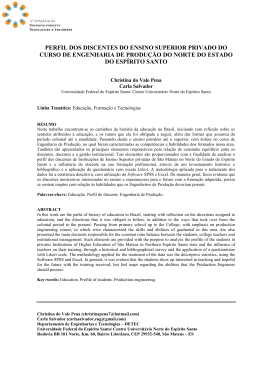
João Pedro Costa
A renovação
urbana nos
grandes complexos
portuarios do século
XX: novas territórios,
novas dinâmicas
Tratando-se de um tema urbanístico relativamente estudado, a
renovação urbana das zonas portuárias (e industriais ribeirinhas)
que acompanha as transformações económicas, comerciais e tecnológicas nas cidades pós-industriais conhece na actualidade
uma nova expressão, à medida que se afasta das áreas centrais
de formação oitocentista e passa a incidir sobre os grandes complexos industriais criados já em meados do século XX.
Uma primeira geração de renovação urbana de zonas portuárias
A histórica recente desta dinâmica urbana é de todos conhecida e
seguiu uma sequência de casos: a partir das cidades norte-americanas, ainda na década de sessenta1, com continuidade na Europa desde os anos setenta e início dos anos oitenta2, momento em
que várias cidades começaram a enfrentar as dinâmicas de libertação territorial nos seus brown fieds ribeirinhos3. Todavia, estes
grandes projectos de retorno à frente de água conheceram a realização efectiva, de forma generalizada, a partir da década de
noventa4.
Importa ter presente que esta cronologia mais ou menos consensual respeita em específico a um único tipo de transformação de
antigas zonas portuárias: tratam-se de intervenções que incidem
sobre territórios de grande dimensão e que, consoante o caso,
beneficiaram de regimes de execução de excepção por comparação com os procedimentos urbanísticos correntes5.
De qualquer modo, uma outra característica urbanística é comum
à maior parte dessas grandes intervenções: o facto dos territórios
portuários terem sido formados, o mais tardar, no final do século
XIX e transição para o século XX; corresponderam a zonas chave
na economia industrial do tempo do combustível carvão e localizaram-se em áreas centrais em relação aos tecidos urbanos históricos das respectivas cidades.
Ainda que cada caso seja diferente, essa sua inserção urbana foi
Urban Regeneration in
the Major Ports in the
20th Century:
New Territories, New
Dynamics
The urban regeneration of port zones
(and riverside industries) that has taken
place at the same time as the economic,
commercial and technological transformation of cities in the post-industrial era
has occurred is an urban planning question that has been the subject of considerable research work and studies, but the
expression has now taken on a new
meaning, as the central areas that date
back to the eighteenth century have been
cleared away and the process has begun
to affect the major industrial complexes
that were established midway through
the twentieth century.
A First Generation of Urban
Regeneration in Port Zones
The recent history of this urban phenomenon is well known to all and followed a distinct sequential pattern: it started in North
American cities in the 1970s1, Europe following the same course in the 1970s and at
the beginning of the 1980s2, which is when
several cities began to tackle the problem
of releasing the land in their brownfields
along the riverside3. These major riverfront
projects started to become much more
generalised in the 1990s4.
It must be borne in mind that this chronology of events basically involved one single type of transformation in the old port
zones: and these actions affected large
areas of land that, depending on each particular case, were to benefit to a greater
or lesser extent from special forms of
implementation when compared with the
existing urban planning procedures5.
However, there is another urban planning
characteristic that is inherent to many of
these major development schemes: the
fact that the port land that had been
established – at the very latest, towards
the end of the 19th Century or in the
early 20th Century –, was in zones that
were vital to the industrial economy at a
time when coal was the main source of
fuel, and this land was to be found in
areas that were centrally placed with
respect to the historical centres of the
respective cities.
Although every case has its own peculiarities and differences, the fact that this
land was to be found in the urban area
played a particularly decisive role in the
functional imbalance that was starting to
become evident with the process of transition towards a post-industrial economy: the central location gave rise to
problems of an environmental nature
where urban life was concerned and
brought about conflicts with respect to
road and rail access; the characteristics
of the ports were no longer ideal; the
industrial buildings themselves dating
back to the turn of the century lost much
of their operational potential and some
of them came to be regarded merely as
examples of industrial archaeology.
At the same time, there was a growth in
the tourist and leisure industries, and
these centrally located zones were in an
ideal and privileged position for redevelopment. Therefore it was now possible
to reclaim the riverside areas and put
them to new recreational uses, thus
greatly enhancing the cities themselves.
This particular setting gave rise to a
series of urban planning contexts that
were common to the respective transformation processes, namely: 1) integration,
to a greater or lesser extent, between
particularmente determinante no desajuste funcional que se foi
tornando evidente na transição para a economia pós-industrial: a
localização central levantou problemas de compatibilidade
ambiental com a vida urbana e gerou conflitos com as acessibilidades viárias e ferroviárias; as características portuárias deixaram
de ser as ideais; os próprios edifícios industriais da transição do
século perderam capacidades funcionais e alguns começaram a
ser vistos como peças de arqueologia industrial.
Em simultâneo, o desenvolvimento da economia do turismo, lazer
e recreio encontrou nestas áreas centrais localizações privilegiadas para a transformação urbana, permitindo reconquistar frentes
ribeirinhas e revalorizar as próprias cidades.
Este quadro resultou assim na ocorrência de um conjunto de
dimensões urbanísticas comuns nos respectivos processos de
transformação, designadamente: 1) a maior o menor integração
entre os novos espaços e os tecidos antigos vizinhos; 2) a criação
de equipamentos colectivos e espaços públicos, compensando as
lacunas existentes nesses tecidos urbanos preexistentes; 3) o
lidar com o efeito barreira dos corredores longitudinais de infraestrutura; 4) a reutilização de património industrial; 5) o desenho
dos novos espaços de relação da cidade com o seu plano de água,
e; 6) a definição dos respectivos programas de intervenção, associados aos novos equipamentos públicos, ao terciário e habitação,
ao turismo e recreio6.
Esta primeira lógica de grandes intervenções de renovação urbana de antigas frentes portuárias – incidindo sobre as zonas centrais, vizinhas de tecidos urbanos consolidados, e resultantes de
uma primeira industrialização – marca uma tipologia de adaptação de espaços económicos da cidade industrial a espaços urbanos contemporâneos.
¬ There was an existing infrastructure
capacity, which could make it possible to
develop new programmes for modern
use, which were not only compatible
with the urban development, thus opening up potential for developing multifunctional programmes;
¬ The possibility of planning several plots
of land in a comprehensive way, transferring buildability and coordinating programmes.
To a certain extent, the key role is the
unrepeatable opportunity that urban
renewal of port areas dating back to the
eighteenth century or earlier gave to the
urban centres of many cities, because it
could now take place on a metropolitan
scale, when those concerned began to
consider as a whole, the transformation
of the large areas of land on the periphery that were gradually being freed from
occupation by the industries that were
established midway through the 20th
Century.
To put it more clearly: just as the redevelopment of the old central port made it
possible to restructure the city, the major
industrial areas along the riverbanks that
sprang up midway through the 20th Century could help to restructure the metropolis – balancing centralities, developing
infrastructures, modernising or using and
encouraging development in nearby urban
zones that also lay in peripheral areas.
An Example: the Major Complexes
along the South Bank of the Tagus,
in Lisbon
In Lisbon, this state of affairs dates back
to midway through the 1990s, having its
roots in the gradual releasing – at different stages and with different characteristics – of the major industrial areas at
Margueira (which was once a naval shipyard covering a surface area of 80
hectares), Siderurgia (metallurgy and
steel industry, partially operational, covering 480 hectares) and Quimiparque
(chemical industry which was gradually
being run down, covering 280 hectares,
60 of which were under the jurisdiction
of the Port of Lisbon).
The land at Margueira had been the subject of several urban development plans
since 1996, and the terrain is characterised by its isolated nature brought
about by the relief, access being rather
difficult from the north and the south, both
5
Transforming the Major Riverside
Industrial Complexes that had
Developed in the Second Half of the
20th Century
More recently still, a new aspect has
emerged in the process of releasing former port land and riverside industrial
complexes – raising fresh questions
about the transformation process that
are well worth evaluating.
I am referring specifically to the releasing of industrial land that was built upon
midway through the 20th Century, sometimes as late as the 1960s, following the
logical patterns set out by the petrochemical, metallurgical, steel and naval
industries, etc.; these industries often
grew up simultaneously in several extensive areas at a certain distance from
each other.
As a general rule, although this land covered more extensive surface areas, it
was no longer as close to the city centres
to which it belonged, the locations tending to be more peripheral – being selected precisely for this reason7.
In certain specific cases, the releasing of
the land or the fact that the former activity had been rendered obsolete created a
series of problems and gave rise to different scenarios that were to determine
the urban planning policies in the following years, namely:
¬ The metropolitan extension that these
areas covered, not only because of the
fact that they were at a greater distance
from the urban centre, but also because
they lay in several major areas of land at
the same time;
¬ The restructuring or development of the
major metropolitan infrastructure;
¬ An inability to implement the urban redevelopment programmes used before - not
only because the original potential is not
great, but also because the greater extension rendered it impossible for the market
to respond within reasonable deadlines;
Vista das instalações industriais da Companhia
União Fabril no Barreiro (CUF, actual Quimiparque)
ainda em expansão durante a década de
cinquenta.
View of the industrial facilities belonging to the
Companhia União Fabril on the Barreiro Industrial
Estate (CUF, now Quimiparque) still in expansion
in the 1950s.
temas
the newly created spaces and the old
neighbourhoods; 2) the setting up of public facilities and amenities and public
zones, to make up for the deficiencies in
the urban fabric that had existed beforehand; 3) responsibility for a barrier effect
being caused by longitudinal infrastructure corridors; 4) the reuse of industrial
heritage; 5) the creation of new zones
that ensured that the city now had a closer relationship with the water, and; (6)
the drawing up of the different development programmes, associated with the
new public facilities and amenities,
either tertiary and residential, or tourism,
leisure and recreation6.
These first major urban redevelopment
projects for the former port and harbour
waterfronts – affecting the central
zones, and the old and tight-knit fabric of
urban neighbourhoods, resulting from
the first industrialisation processes –
established a trend in turning the economic zones in industrial cities into contemporary urban zones.
6
topics
A transformação dos grandes complexos industriais
ribeirinhos da metade do século XX
Mais recentemente, todavia, tem começado a emergir um novo
tema no processo de libertação de antigos terrenos portuários e
industriais ribeirinhos – levantando novas questões no seu processo de transformação que importa começar a avaliar.
Refiro-me em concreto à libertação de terrenos industriais criados
já em meados do século XX, alguns até nos anos sessenta, segundo as lógicas específicas das indústrias petroquímica, metalomecânica ou naval – fenómeno muitas vezes simultâneo em
várias grandes áreas afastadas entre si.
Tratam-se de terrenos, regra geral, ainda de maior dimensão, já
não vizinhos dos tecidos urbanos centrais das cidades em que se
inserem, mas antes com localizações periféricas – então intencionalmente escolhidas exactamente por essa razão7.
Em casos concretos, a libertação dos terrenos ou a obsolescência
da actividade existente colocam vários novos problemas que certamente começarão a marcar as políticas urbanas dos próximos
anos, designadamente:
¬ A dimensão metropolitana que a abordagem a esses territórios
coloca, não apenas devido à sua localização mais periférica, mas
também porque, com frequência, a questão colocar-se-á em
simultâneo em vários grandes terrenos;
¬ A reestruturação ou desenvolvimento da grande infra-estrutura
metropolitana;
¬ A incapacidade de aplicação dos programas da renovação urbana anteriormente utilizados - não só o potencial inicial já não é tão
grande, como também a maior extensão gera uma incapacidade
de resposta do mercado para prazos razoáveis;
¬ A ainda existente capacidade de infra-estrutura, que pode permitir desenvolver novos programas de emprego modernos, em
parte compatíveis com o desenvolvimento urbano, assim abrindo
a possibilidade de desenvolver programas multifuncionais;
¬ A possibilidade de, ao planear vários territórios de forma integrada, transferir edificabilidades e coordenar programas.
Em certa medida, o papel chave e a oportunidade irrepetível que
a renovação urbana das áreas portuárias oitocentistas ou anteriores significou para as zonas urbanas centrais de diversas cidades,
pode agora voltar a ocorrer à escala metropolitana, quando se
começar a pensar em conjunto a transformação dos grandes terrenos periféricos que pouco a pouco vão sendo libertos pela ocupação industrial da metade do século XX.
Dito de forma mais clara: tal como a renovação do antigo porto
central permitiu reestruturar a cidade, também as grandes áreas
industriais ribeirinhas de meados do século XX poderão permitir
reestruturar a metrópole – reequilibrando centralidades, desenvolvendo infra-estruturas, modernizando o emprego e induzindo
desenvolvimento em zonas urbanas vizinhas também periféricas.
of which are heavily built-up areas; this
was then complicated by being subject to
a public financial guarantee amounting to
225 million Euros, from a real estate fund,
as a result of the process of restructuring
the company in 1993. The successive
urban planning proposals that ensued
invariably came to nothing because of
these commitments, so the land remained
as it was for the time. A new proposal is
currently being dealt with that will only be
able to cover part of this amount, which
will leave in doubt how the State will be
able to settle the rest.
With respect to the land covered by
Siderurgia – a company that was also
restructured in 1993 – a mere 90
hectares are still given over to industrial
activity, part of the remaining land being
heavily affected by environmental liabilities. Certain well-known plans have been
made to transform this land, including
splitting it up into industrial zones and
creating a business park.
Since 2001, the land at Quimiparque has
been the subject of at least two general
redevelopment plans, although the developing company itself is still hesitant and
continues to make a profit from its assets
through several temporary activities that
take place there - waiting for a more
interesting proposal in the future that
needs to be carried out more swiftly. The
potential for transforming the land is
great, and it could feel the benefits of the
planned construction of a road-rail crossing that will span the River Tagus and link
Barreiro with Chelas, on the north bank.
The prospect of the Regional Land Planning Scheme for Lisbon and the Tagus
Valley, approved and accepted in 2002,
emerged in this particular context; this
plan defines these zones as «areas with
restructuring/conversion potential», crucial for one of its main ideas, which
involves recentering the metropolis on
the River Tagus. In this context, in 2002
and 2003, the Government put forward a
proposal that involved the possibility of
including the three major tracts of land
into one single joint action, which was
then known as Baia do Tejo. It has
recently been stated that some of these
ideas are to be taken up, although this
has yet to be confirmed.
This brief and summarised account
serves to highlight the new problems
that are having to be faced when transforming the major industrial complexes
from midway through the 20th Century,
these problems being different from the
ones that had to be overcome with the
first generation of urban redevelopment
plans for port waterfronts.
Um exemplo: os grandes complexos do arco ribeirinho
sul do Tejo, em Lisboa
Em Lisboa esta realidade germina já desde meados da década de
noventa, tendo por base a progressiva libertação – em estádios distintos e com características próprias – das grandes áreas industriais
da Margueira (um antigo estaleiro naval com 80 hectares), Siderurgia
Notes
1. Although other cases can also be mentioned, the ones that are most extensively
referred to in the specialist literature are
the Inner Harbour in Baltimore and Downtown Waterfront in Boston, in the 1960s,
or the Harbour Front Project in Toronto,
which was carried out in the 1970s.
2. For example, Liverpool Docklands, in
the 1970s, or the one that epitomised the
whole concept, which was the London
Docklands Development Corporation, at
the beginning of the 1980s.
3. Several European cities make reference to their first attempts to deal with
the phenomenon of releasing land that
formerly belonged to the ports and redeveloping it for urban use, either through
initiatives covering small areas, or by
carrying out their initial studies in order
to pave the way for the major operations
that they would be conducting at a later
date.
4. In a relatively limited period of time,
most of these cases that had then be verified could be illustrated, among many
others, by Kop van Zuid in Rotterdam,
Port Vell in Barcelona, Innenhafen in
Duisburg, West Harbour in Helsinki, Victoria’s New Waterfront in Melbourne,
Darling Harbour in Sydney, Aker Brygge
in Oslo, West Harbour in Frankfurt, as
well as the beginning of the redevelopment of Porto Vecchio in Genoa, LuJiaZui
in Shanghai, HafenCity in Hamburgo, or
the Eastern Docklands in Amsterdam.
5. One must not forget that other types of
riverside transformations also took
place, such as those that initiated or
paved the way for projects on a larger
scale (ones that are better known) that
were to be carried out 1980s, namely
access to the renovation of plots of riverside land that had fallen into disuse that
lay in transition zones in pre-existing
urban contexts. We would make reference to three out of the many cases that
could be cited to illustrate this trend,
namely, the office complex owned by the
publishing house, Gruner & Jahr, in Hamburg (Otto Steidle and U. Kiessler, 1983),
or the housing estate Peperklip, at Binnenhaven, in Rotterdam (Carel Weber,
1981), or the widely publicised case of
Casa dos Bicos, in Lisbon (José SantaRita and Manuel Vicente, 1981).
6. For further information concerning the
different types of transformation for
riverfronts and the different urban planning dimensions, refer to: COSTA, João
Pedro (2006). The Riverside between
Projects. Training and transformation of
port land, the Lisbon case. Thesis (PhD),
TU Barcelona, ETSAB. Barcelona, Spain.
7. This new reality can be well illustrated
by such cases as the large areas of land
in Margueira, Siderurgia and Quimiparque on the southern banks of the River
Tagus in Lisbon, or the northernmost part
of the Huangpu, in Shanghai, the central
part of the River Elbe, in Hamburg (the
development of the concept of Sprung
über die Elbe – Leap of the Elbe), or by
the project planned in 2004 for Merwehaven, Waalhaven and Eemshaven, in
Rotterdam, but delayed and partially
abandoned.
7
Note
1. Ainda que outros casos possam ser também mencionados, os
casos mais referenciados na bibliografia de especialidade são, o
Inner Harbour de Baltimore e a Downtown Waterfront de Boston,
ainda na década de sessenta, ou o Harbourfront Project em Toronto, no inicio da década de setenta.
2. Por exemplo, as Liverpool Docoklands, nos anos setenta, ou o
caso paradigma que foi a London Docklands Development Corporation, no início dos anos oitenta.
3. Encontram-se em várias cidades europeias referências às primeiras tentativas de enfrentar o fenómeno da libertação do solo
portuário e da sua reconversão para uso urbano, seja mediante
propostas de âmbito territorial mais reduzido, sejam alguns primeiros estudos não realizados que de certa forma abriram caminho às grandes operações posteriormente realizadas.
4. Com pequenas oscilações temporais, o grande volume de casos
então verificados pode ser ilustrado, entre muitos outros, por Kop
van Zuid em Roterdão, pelo Port Vell em Barcelona, pelo Innenhafen em Duisburgo, pelo West Harbour em Helsinquia, pela Victoria’s New Waterfront em Melbourne, pelo Darling Harbour em
Sydney, por Aker Brygge em Oslo, pelo West Harbour em Frankfurt, pelo inicio da transformação do Porto Vecchio em Génova,
por LuJiaZui em Xangai, pela HafenCity em Hamburgo, ou pelas
Eastern Docklands em Amesterdão.
5. Não deve ser esquecida a existência de outros tipos de transformações ribeirinhas, como os que iniciaram e abriram caminho
aos projectos de maior dimensão (mais conhecidos) e que foram
tendo lugar desde o inicio da década de oitenta, designadamente
as acções de renovação de parcelas ribeirinhas desocupadas inseridas em localizações de transição para contextos urbanos preexistentes. Entre muitos outros disponíveis, três casos podem exemplificar essa dinâmica, nomeadamente, o complexo de escritórios
do grupo editorial Gruner & Jahr, em Hamburgo (Otto Steidle e U.
Kiessler, 1983), o complexo residencial Peperklip, no interior do
Binnenhaven, em Roterdão (Carel Weber, 1981), ou o caso então
muito divulgado da intervenção na Casa dos Bicos, em Lisboa
(José Santa-Rita e Manuel Vicente, 1981).
6. Sobre os diferentes tipos de transformação de frentes ribeirinhas e respectivas dimensões urbanísticas vide: COSTA, João
Pedro (2006). La Ribera Entre Proyectos. Formación y transformación del territorio portuario, a partir del caso de Lisboa. Thesis
(PhD), TU Barcelona, ETSAB. Barcelona, Espanha.
7. Esta nova realidade é ilustrada por casos como os grandes territórios da Margueira, Siderurgia e Quimiparque na margem sul do
Tejo, em Lisboa, pelo extremo norte do Huangpu, em Xangai, pelo
território central do Elbe, em Hamburgo (no desenvolvimento do
conceito do Sprung über die Elbe – Salto sobre o Elbe), ou pelo projecto previsto em 2004 para Merwehaven, Waalhaven e Eemshaven, em Roterdão, entretanto adiado e parcelarmente abandonado.
temas
(industria metalomecânica, parcialmente em funcionamento, com
480 hectares) e Qumiparque (industria química em desactivação, com
280 hectares, 60 sob jurisdição do Porto de Lisboa).
Tendo conhecido várias propostas de desenvolvimento urbano
desde 1996, os terrenos da Margueira são caracterizados pelo isolamento provocado pelo relevo, sendo apenas acessíveis pelos
seus extremos norte e sul, ambos densamente urbanizados; acresce ainda a pendência de uma garantia financeira pública de 225
milhões de Euros, mediante um fundo imobiliário, resultante do
processo de reestruturação da empresa em 1993. As sucessivas
propostas de urbanização conhecidas têm sido sempre desajustadamente densas devido a esse compromisso, mantendo-se o
terreno em expectativa. Na actualidade está em curso uma nova
proposta que permitirá cobrir apenas parte desse valor, questionando-se de que forma o Estado liquidará o valor remanescente
num contexto de contenção orçamental.
Nos terrenos da Siderurgia – empresa também reestruturada em
1993 – apenas 90 hectares continuam afectos à actividade industrial, encontrando-se parte dos restantes terrenos fortemente
afectados por passivos ambientais. São conhecidas propostas de
transformação desses terrenos, nomeadamente um parcelamento
industrial a desenvolver como polo empresarial.
Os terrenos da Quimiparque conheceram desde 2001 pelo menos
dois planos gerais de transformação, ainda que a própria companhia promotora continue hesitante e siga rentabilizando o eu património mediante várias ocupações provisórias – de certa forma
aguardando por um enquadramento superior que urge realizar. O
potencial de transformação dos terrenos é grande, podendo vir a
beneficiar da construção prevista de uma travessia rodo-ferroviária
do Tejo que ligará o Barreiro a Chelas, na margem norte.
A esta visão isolada de cada complexo acresce a perspectiva do
Plano Regional de Ordenamento do Território de Lisboa e Vale do
Tejo, aprovado em 2002, que identifica estas zonas como «áreas
com potencial de reconversão», cruciais para consubstanciar uma
das suas ideias fortes que é a de recentrar a metrópole sobre o
Tejo. Nessa sequência, o Governo chegou a desenvolver, entre
2002 e 2003, uma proposta que coordenava os três grandes territórios numa acção conjunta – então designada por Baia do Tejo.
Recentemente existem referências de que algumas dessas ideias
estariam a ser retomadas, embora careçam de confirmação.
Rapidamente enunciado, este caso serve para ilustrar os novos
problemas que se colocam com a transformação dos grandes complexos industriais da metade do século XX, distintos daqueles que
se colocaram numa primeira geração da renovação urbana de
frentes portuárias.
Baixar