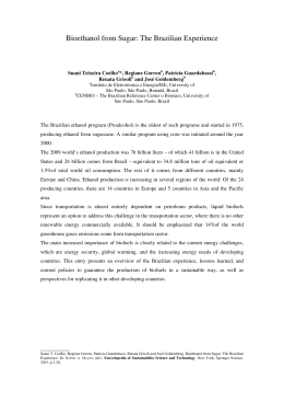
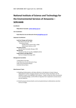
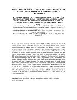
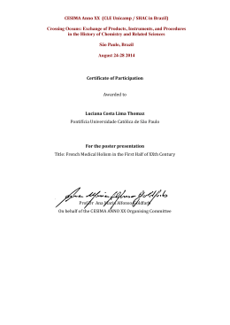
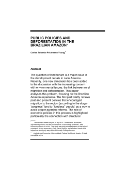
BOIS ET FORÊTS DES TROPIQUES, 2004, N° 280 (2)
FORÊTS AMAZONIENNES
17
BRÉSIL
Contrasted land use
and development trajectories
in the Brazilian Amazon
Benoît Mertens1
Marie-Gabrielle Piketty2
Adriano Venturieri3
Diogenes Alves4
Jean-François Tourrand5
Using two case studies in the state of Pará (Brazil), Uruará (Transamazon) and
São Félix do Xingú (Southern Pará), the current paper analyzes the landscape dynamics in
contrasted frontier areas. It examines how these dynamics are related to infrastructure
development, ecological conditions, land tenure and fiscal policies, and to the evolution and
organization of the production, consumption and marketing chains of livestock products.
1
Center for International Forestry
Research (CIFOR)
C/o CIRAD-Forêt
Campus de Baillarguet, TA 10 D
34398 Montpellier, France
2 CIRAD/USP-FEA-PROCAM
Universidade de São Paulo
Av. Prof. Luciano Gualberto, 908,
Cidade Univ., 05508-900 São
Paulo, SP, Brazil
3
Empresa Brasileira de Pesquisa
Agropecuária (EMBRAPA)
Tv. Enéas Pinheiro s/n,
Cx. Postal 48, 66095-100, Belém,
PA, Brazil
4 Instituto Nacional de Pesquisas
Espaciais (INPE)
Av. dos Astronautas, 1758,
São José dos Campos, SP,
CEP 12227-010, Brazil
5
CIRAD/UnB-CDS
Universidade de Brasilia
SAS Qd.5, Lote H., Edif. IBAMA,
2°andar, Brasilia, DF, Brazil
Fragmented landscape along the Transamazon highway.
Photo J.-F. Tourrand.
18
BOIS ET FORÊTS DES TROPIQUES, 2004, N° 280 (2)
AMAZONIAN FORESTS
Benoît Mertens,
Marie-Gabrielle Piketty,
Adriano Venturieri,
Diogenes Alves,
Jean-François Tourrand
BRAZIL
RÉSUMÉ
ABSTRACT
RESUMEN
DIVERSITÉ D’UTILISATION
ET DE MISE EN VALEUR DES TERRES
EN AMAZONIE BRÉSILIENNE
CONTRASTED LAND USE
AND DEVELOPMENT TRAJECTORIES
IN THE BRAZILIAN AMAZON
DIVERSIDAD DE USOS
Y APROVECHAMIENTO DE TIERRAS
EN LA AMAZONIA BRASILEÑA
La forêt amazonienne, plus grand
massif forestier tropical sur terre,
subit un déboisement rapide depuis
quatre décennies. En Amazonie brésilienne, les fronts pionniers se concentrent dans l’Arc de déforestation.
Dans cette vaste zone, des processus
de changements variés interagissent
au travers de plusieurs modes d’utilisation et de mise en valeur des terres.
À partir de deux études de cas dans
l’État du Pará (Brésil), cet article analyse les dynamiques du paysage dans
ces fronts pionniers très contrastés et
examine l’influence de facteurs tels
que le développement des infrastructures, les conditions écologiques, les
régimes fonciers, les politiques fiscales ainsi que l’organisation et l’évolution des filières bovines. Les principaux objectifs sont d’illustrer, d’une
part, la variabilité spatiale et temporelle des opportunités ou contraintes
à la conversion des forêts à des fins
agricoles et, d’autre part, comment
des conditions biophysiques et socioéconomiques contrastées affectent
les dynamiques actuelles et futures
de l’utilisation du sol et du développement régional. L’approche repose
sur la collecte et l’intégration de
variables-clés économiques et biophysiques dans une base de données
géoréférencées. Les outils d’analyse
de paysage et la construction de
modèles économétriques conduisent
à l’analyse statistique conjointe des
processus de changements d’utilisation du sol et des facteurs observables qui les influencent.
The Amazon is the largest tropical forest area on Earth, and is undergoing
rapid deforestation since the last four
decades. These conversions are mostly
located in frontier areas distributed
along the so-called “arc of deforestation”. Within this large zone, various
land use change processes are interacting through several modes of land
valorization and organization. From
two case studies in the state of Pará
(Brazil), the current paper aims at analyzing how these landscape dynamics
in contrasted frontier areas are related
to infrastructure development, ecological conditions, land tenure and fiscal
policies, and to the evolution and the
organization of the production, consumption and marketing chains of livestock products. The main objectives
are to illustrate the spatial and temporal variability regarding incentives and
disincentives to convert tropical forests
for other agricultural uses and how do
contrasted biophysical and socio-economic conditions (such as accessibility
or land tenure) affect current and
future land use and development trajectories, with a particular emphasis
on the role of roads infrastructure. This
study draws on complementary
datasets, socio-economic census, keyinformants interviews and satellite
remote sensing imagery, linked with
geo-referenced information on human
and biophysical conditions. These data
were integrated in a GIS, and the analyses were supported quantitatively by
using spatial econometric modelling
approaches and landscape ecology
tools.
La selva amazónica, el mayor bosque
tropical del planeta, sufre una rápida
deforestación desde hace cuatro
décadas. En la Amazonia brasileña,
los frentes pioneros se concentran en
el Arco de deforestación. En esta
extensa zona, existen diferentes procesos de cambios interactuando
mediante distintos métodos de utilización y aprovechamiento de las tierras. A partir de dos estudios de
casos en el Estado de Pará (Brasil),
este artículo analiza las dinámicas
del paisaje en estos frentes pioneros,
muy diferentes entre sí, y examina la
influencia de factores como el desarrollo de las infraestructuras, las condiciones ecológicas, los sistemas de
tenencia de tierras, las políticas fiscales y la organización y evolución del
sector bovino. Los principales objetivos consisten en ilustrar, por una
parte, la variabilidad espaciotemporal de las oportunidades o limitaciones para la transformación de los
bosques en tierras agrícolas y, por
otra parte, el cómo las diferentes condiciones biofísicas y socioeconómicas afectan las dinámicas actuales y
futuras de la utilización del suelo y
del desarrollo regional. El planteamiento se basa en la recogida e integración de variables clave económicas y biofísicas dentro de una base de
datos georreferenciada. Las herramientas de análisis del paisaje y la
construcción de modelos econométricos conducen al análisis estadístico
conjunto de los procesos de cambios
de utilización del suelo y de los factores observables que los influyen.
Keywords: Amazon, Brazil, frontier,
colonization, livestock, road, deforestation.
Palabras clave: frente pionero, colonización, ganadería, carretera, deforestación, Amazonia, Brasil.
Mots-clés : front pionnier, colonisation, élevage, route, déforestation,
Amazonie, Brésil.
BOIS ET FORÊTS DES TROPIQUES, 2004, N° 280 (2)
FORÊTS AMAZONIENNES
BRÉSIL
Introduction
The Amazon, the largest tropical
forest area on earth, has undergone
rapid deforestation in the last four
decades. From the early 1960s the
Brazilian government decided to initiate
large-scale development programs
aimed at integrating the Amazon region
into the national economy, which had
a significant impact on land use
change. The total deforested area
in the Brazilian Amazon grew from
152 200 km2 in 1978 to 415 200 km2 in
1990, and 587 727 km2 in 2000 (INPE,
2002). For the period 1978-1989 INPE
statistics report a yearly rate of gross
deforestation of 0.54 % (21 130 km2.y-1).
The rate declined somewhat in the early
1990s, remaining below 15 000 km2.y-1
for a major part of the 1990s, but
rebounding once more to a high level in
the late 1990s to reach 0.52 percent or
almost 19 000 km2.y-1 in 2000 (INPE,
2002). In addition to deforestation,
large expanses of forest are being
degraded by habitat fragmentation,
edge effects, selective logging, surface
fires, gold mining, overhunting and
other activities (e.g., Nepstad et al.,
2001).
Land use in the Amazon is strongly shaped by roads and past settlement patterns. Deforestation in the
1990s for the entire Legal Amazon tended to be concentrated in limited
regions, growing inertially around
areas of previous deforestation and
major roads. About 90 percent of
Amazon deforestation has taken place
within 100 km of major paved highways (Alves, 2002) and national development plans such as “Avança
Brasil” would rapidly increase the
supply of forest land through the
paving of more than 6 000 km of roads
in the Amazon (Laurance et al., 2001).
In fact, deforestation across the
Brazilian Amazon has not proceeded
in a random fashion (McCracken et
al., 2002): the highest rates were
observed in areas along the BélemBrasília and the Cuiabá-Porto Velho
highways – the so-called arc of deforestation (Figure 1). Lower deforestation rates affected the regions along
the Cuiabá-Santarém and the
Transamazon highways. The dominant land use following deforestation
is pasture for cattle ranching, as a
result of the relocation of the
Brazilian cattle herd from the southeast area of the country into the southern part of the Amazon Basin
(Poccard-Chapuis, 2004).
Using two case studies in the
state of Pará (Brazil), the current
paper will analyse how landscape
dynamics in contrasted frontier areas
are related to infrastructure development, ecological conditions, land
tenure and fiscal policies, and to the
evolution and organization of the production, consumption and marketing
chains of livestock products. The
aims are to illustrate the spatial and
temporal variability regarding incentives and disincentives for converting
tropical forests to other agricultural
uses, and to show how contrasted
biophysical and socio-economic
conditions affect current and future
land use and development trajectories, with a particular emphasis on
the role of road infrastructure. The
first section will provide a brief overview of the existing literature on land
use models looking at this issue in
the Brazilian Amazon, while the
second section will focus on the comparison of deforestation patterns in
the two study areas (Figure 2).
Complementary datasets were collected, from socio-economic censuses,
key-informant interviews and satellite
remote sensing imagery, linked with
geo-referenced information on
human and biophysical conditions.
This data was integrated in a GIS and
the comparisons were supported
quantitatively by using spatial econometric modelling approaches and
landscape ecology tools.
Figure 1.
Legal Amazon, main road infrastructure and Arc of deforestation.
19
20
BOIS ET FORÊTS DES TROPIQUES, 2004, N° 280 (2)
AMAZONIAN FORESTS
BRAZIL
Previous land use
change modelling
studies in the
Brazilian Amazon
There is an increasing literature
in the field of land use change modelling applied in the Brazilian Amazon1.
As land use in the Amazon is strongly
shaped by roads and past settlement
patterns, it is not surprising to see
that the impact of roads on deforestation has been considered in most of
the studies and that there is a broad
consensus regarding the influence of
paved highways on increasing deforestation, at least at the national or
sub-national scale.
Andersen, Reis (1997) looked at
the relationships between deforestation and development policies for the
period 1970 to 1985 and concluded
that while subsidized credit implied a
relatively good trade-off between economic growth and deforestation, large
road building projects had a much less
favourable trade-off. Intensive transport infrastructure development inside
the agricultural frontier seems to have
a less harmful impact on deforestation
than extensive development because
it may favour land use intensification
(Pfaff, 1997; Berardo et al., 1998).
Moreover, if paving projects within
existing frontiers were accompanied
by investments in education and
health services, as well as marketing
facilities, they might foster socially
equitable rural development and longterm prosperity (Nepstad et al., 2001).
Therefore, it is still difficult to
predict, without large error margins,
the location and intensity of deforestation that would be associated
with road building or improvement.
For instance, Nepstad et al. (2001)
underline the different potential
impact of road building according to
the specific environment of the subregions. Mertens et al. (2002) show
that the impact of the roads depends
on the type of road, the stage of
development of the frontier area and
the type of producers. Cattaneo
Figure 2.
State of Pará and study areas.
Large-scale cattle ranching in São Félix do Xingú.
Photo B. Mertens.
1 Most
land use change models applied in the Brazilian Amazon are categorized as nonspatial models since they do not provide any information about the specific location of
forest clearing or take into account the spatial distribution of landscape elements and
adjacency effects.
BOIS ET FORÊTS DES TROPIQUES, 2004, N° 280 (2)
FORÊTS AMAZONIENNES
BRÉSIL
(2002) highlights the fact that the
magnitude of the impact of road
building depends on the regional
level of production factor flows following road building. Existing studies
do not always agree on the impact of
unpaved roads. Pfaff (1997) does not
find a positive impact of unpaved
road on deforestation whereas
Ferraz (2001) and Mertens et al.
(2002) do. Surprisingly, few studies
have been carried out at a finer scale
to examine these relationships.
The main puzzling aspect on the
issue of road building is the fact that
most deforestation is linked to extensive cattle ranching, which is structurally less sensitive to transport costs
than any other agricultural activity. Most
of the models have not addressed the
potential impact of road building on the
establishment of associated local agroprocessing factories. Following recent
theoretical works in the field of regional
economics (Fujita et al., 1999), it may be
assumed that improving road infrastructure toward agricultural frontier
areas has a negative local impact in the
first instance (i.e. the agro-processing
factories remain in their regions of origin but stock up with products from the
frontier areas at lower cost), and a positive local impact in the second instance
(i.e. new factories tend to be built within
the frontier area). The dynamic effects
depend particularly on the type of product, the level of economies of scale,
local infrastructure and forwards and
backwards linkages. Most of the actors
surveyed in several agricultural frontiers
in the Brazilian Amazon pointed out that
access to markets for livestock products
was a main determinant of the expansion of cattle ranching in the Amazon
(Veiga et al., 2001). On the other hand,
credit policies tried to promote the
development of agro-forestry systems,
but met with failure due to the fact that
access to markets for these products
was not secured. It is therefore necessary to achieve a better understanding
of the determinants of the location of
agro-processing factories inside or outside of the Amazon Basin, in order to
fully understand possible future land
use change trajectories.
Diversified production systems in Uruará: recent clearing, annual and perennial crops and pasture.
Photo J.-F. Tourrand.
Two contrasted
patterns of land
use change
dynamics
The region of
São Félix do Xingú
The region of São Félix do Xingú
is located in the southern region of
Pará, in the Eastern Brazilian Amazon
(Figure 2). It is one of the largest
counties (84 000 km2) and has a very
low population density (<0.5 inhabitants per km2), with 77 percent of the
population living in rural areas. In
1982, after successive cycles of forest
resource extraction activities, São
Félix do Xingú was linked by road to
the expanding frontiers areas of
Xinguára (Schmink, Wood, 1992).
From that time on, mining activities,
wood extraction, small farmer settlement projects and livestock activities
stand out as the four successive and
complementary drivers of regional
development. The statistics of the
Instituto Brasileiro de Geografía e
Estatisticas (IBGE) show a rapid inmigration in São Félix do Xingú
county: the population grew from
4 954 in 1980 to 24 834 in 1991, and
to 40 983 in 1996 (IBGE Census and
inter-census data). This process
seems to have been underestimated
as observed in the field, and by
Maturana (2001).
The interpretation of the time
series of satellite remote sensing
Landsat images (1986-1992-1999)
allows the characterization of the land
cover change dynamics that affected
the region (Figure 3). In 1986 the intensive gold mining activities gave the first
impetus to colonization with the arrival
of thousands of gold-diggers, creating
camps that then became towns. Small
plots (50-100 ha) can be distinguished
along tracks built in the forest and
along well organized secondary roads
in the Tucumã sector. On the other
hand, some large-scale properties
(thousands of ha) or fazendas are
already in place, discernable by the
enormity of their size and their geometric form. Contrary to small-scale
farming systems, these fazendas are
isolated from the transport infrastructure. The dense network of logging
tracks also reveals the intensive extraction of valuable woods, in particular
Mahogany (Swietenia macrophylla).
21
22
BOIS ET FORÊTS DES TROPIQUES, 2004, N° 280 (2)
AMAZONIAN FORESTS
BRAZIL
Figure 3.
Forest cover change in São Félix do Xingú.
Table I.
Land cover and land cover change from 1986 to 1999 in São Félix do Xingú.
Land cover
(km2)
Forest
(%)
Pasture/agriculture (km2)
(%)
Deforestationa
1986
1992
1999
55 156,70
52 207,50
47 809,10
98,10
93,70
85,10
491,40
2 940,60
7 839,10
0,80
(km2)
(km2.year-1)
5,20
13,90
2 449,10
4 898,40
408,20
699,70
(%.year -1)
0,74
1,33
(%.year -1)a
1,48
2,66
a For
this adapted yearly rate of deforestation, the reference forest area corresponds to
the forests that are likely to be affected by clearing, i.e. forest areas located outside
indigenous and protected areas.
Table II.
Land cover and land cover change from 1986 to 1999 in Uruará.
Land cover
Forest
2
(km )
(%)
2
Pasture/agriculture (km )
(%)
Deforestation
2
1986
1991
1999
9 577,50
9 342,90
8 705,50
94,90
92,60
86,30
507,00
741,70
1 379,10
5,00
7,30
13,70
234,70
637,30
(km2.year-1)
46,90
79,60
(%.year-1)
0,490
0,85
(km )
The image taken in 1992 reveals
drastic changes in the landscape. This
period corresponds to the end of gold
mining activities and most of the forest
tracks are no longer visible, except in
some areas in indigenous reserves.
Larger pasture areas have replaced the
small patches of clearings observed in
1986, tending to form a thin continuum
along the secondary roads, which have
been extended. A larger still unpaved
road (PA-279) now serves São Félix do
Xingú. The image analysis confirms the
predominance of pasture. For this first
period, from 1986 to 1992, the area of
deforestation was 2 449 km2 (Table I),
which is 408 km2.y-1, or a yearly rate of
deforestation of 0.74 percent.
A higher deforestation rate is
measured for the period 1992-1999,
when the yearly rate of deforestation
reached 1.33 percent or nearly
700 km2.y-1. The area deforested from
1992 to 1999 was 4 899 km2. Globally,
from 1986 to 1999, the forested area
converted to agriculture, mainly for
pasture, totals 7 348 km2 (Table I). In
the core area, a continuum of pasture
monoculture can be observed, with
some remaining forest galleries along
the rivers and small forest blocks as
land or fertility reserves for producers
(Figure 4). Producers now have little
room to increase their property size.
The number and size of the fazendas
continued to increase and the 1992
isolated properties are now forming
larger groups. Some land use patterns
reveal the emerging conflicts or pressure over land, such as forest reserves
surrounded by pasture in large exploitations (to protect them from invasion) and forest clearings in very isolated areas (more than 250 km from the
PA-279) or in marginal mountainous
areas. In response to the decreasing
land availability in the core area, former logging and mining tracks have
been rehabilitated, giving access to
new forest land which colonists and
fazendeiros can acquire through grileiros, who falsify the land titles. An
extensive hierarchic secondary road
BOIS ET FORÊTS DES TROPIQUES, 2004, N° 280 (2)
FORÊTS AMAZONIENNES
BRÉSIL
T h e re g i o n o f U r u a r á
The county of Uruará is located
in the central region of Pará (Figure 2),
along the Transamazon Highway. The
region covers about 10 080 km2 and
has a higher population density (4.2
inhabitants per km2), with around 30
percent of the population living in
urban areas. From 1991 to 2000 the
population almost doubled from
25 339 to 45 201 inhabitants (IBGE
census data). Uruará is an older settlement frontier originally established in
the 1970s as a farming colony along
the Transamazon Highway. The population grew rapidly during the 1970s
due to the state-directed initial colonization efforts. In the days of land distribution the INCRA provided 100 ha
lots to individual households or
migrants, who began clearing the
forest for annual and perennial crops.
Since then some land concentration
has occurred.
Figure 4.
Forest cover change in Uruará.
network is developing. The main obstacles for clearing expansion are large
rivers, which form obstacles to road
construction and mobility, and conservation and indigenous reserves, which
are increasingly surrounded by pasture but are still crossed by tracks for
wood extraction.
São Félix do Xingú can be considered a recent agricultural frontier
which is the focus of land speculation,
cattle expansion and deforestation.
Road construction, investments in
electrical energy, rapid increases in
credit for cattle since 1981 and the
land reform policies of the Instituto
Nacional de Colonização e Reforma
Agraria (INCRA) have all fuelled this
process. All these factors make this
region one of the most dynamic agricultural frontiers in the Brazilian
Amazon. Cattle ranching is by far the
dominant land use in the region, which
recorded one of the highest growths in
cattle herds. A high proportion of the
cattle production is exported to other
states since the region has access to
important national consumption markets for beef and dairy products.
Recent clearing in São Félix do Xingú.
Photo B. Mertens.
23
24
BOIS ET FORÊTS DES TROPIQUES, 2004, N° 280 (2)
AMAZONIAN FORESTS
BRAZIL
Figure 5.
Dominant patterns of forest cover change in São Félix do Xingú.
In the 1980s the economy boomed as a result of the high prices for
cocoa, pepper and coffee, which
attracted even more migrants. Again,
time series of satellite images allow
the characterization of the land use
dynamics that took place in the
region (Figure 5). In 1986, the fishbone pattern of the secondary road
network is already well established,
as it was originally initiated by the
government policies. Secondary
roads, or travessões, are crossroads
running north and south off the main
road to distances of about 30 km.
About 500 km2 of pasture and crops
were established along the main road
and these secondary roads. Annual
and perennial crops accounted respectively for 3.5 and 15.7 percent of
the total non-forest area. Some large
fazendas were established, mostly in
the eastern part of the county,
accounting for about 20 percent of
non-forest areas.
From 1986 to 1991 the area of
deforestation was 235 km2, which is
47 km2.y-1, or a yearly rate of deforestation of 0.49 percent. The image
analyses reveal that most of the land
use changes concerned perennial
crops. Annual and perennial crops
accounted respectively for 1.9 and
31.2 percent of total non-forest area.
The price of pepper still remained
high and provided good returns per
hectare even on poor soils. Few new
large-scale properties were created,
and a small extension of the existing
fazendas can be observed. Most of
the deforestation areas are located
close to the main road and to a lesser
extent along the secondary roads.
In the 1990s decreasing market
prices for key crops, as well as cropspecific diseases such as Crinipellis
perniciosa in cocoa and Fusarium s.
piperi in black pepper, resulted in
bankruptcies among more specialized farmers, and led many landholders to reorient their farming systems
toward pasture for cattle. This period
showed the emergence of mediumsize landholders who took advantage
of these events to acquire cheap land
and constitute small fazendas (hundreds of hectares).
The last period, from 1991 to
1999, is characterized by drastic landscape and land use changes. The area
of deforestation was 637 km2, which
is about 80 km2.y-1, or a yearly rate of
deforestation of 0.85 percent. Most of
the forest clearings are located along
the secondary roads, affecting areas
located far from the Transamazon
Highway. Land use change analyses
reveal a small increase in the annual
crops (4 percent of the non-forest
area), but a sharp decrease of the
perennial crop area, falling to 0.6 percent of the non-forest area. However,
the agricultural census of 1996 indicates a higher proportion of temporary and permanent crops, which still
accounted for about 17 percent of all
deforested areas (IBGE, 1996). These
results seem to confirm the major
shift of the farming systems toward
pasture for cattle, or at least a higher
integration of pasture within diversified production systems.
The county of Uruará can be
considered an older agricultural frontier mostly characterized by the statedirected colonization scheme and a
high proportion of small-scale subsistence farmers with imperfect market
access (Walker et al., 2002). Farming
systems tend to be more diversified,
typically including annuals (such as
rice and beans), perennials (cocoa,
pepper and coffee) and pasture.
Livestock activities, for meat and
dairy products, became the dominant
land use in the region.
BOIS ET FORÊTS DES TROPIQUES, 2004, N° 280 (2)
FORÊTS AMAZONIENNES
BRÉSIL
Cocoa field.
Photo A.-E. Lacques.
Spatial and temporal
variability: evidence from
econometric land use
change models
Spatial statistical models are
useful tools for identifying and evaluating the relationship between deforestation and spatially explicit explanatory variables such as accessibility,
biophysical conditions, land tenure
and zoning restrictions. These models
are well suited for understanding
where deforestation is more likely to
occur in the future and therefore
where policies aimed at reducing
deforestation should be applied.
Binary and multinomial logistic
regression models were run for each
period and study area. This method is
used to model how the value of a set of
independent variables affects the presence or absence of deforestation. The
independent variables considered aim
to capture the main biophysical and
socio-economic explanatory factors
that are likely to influence the patterns
and/or the intensity of deforestation2.
The overall fits of the models are significant for all periods, with pseudo-R2
ranging from 0.29 to 0.48. It should be
remembered that such models do not
claim to explain all the causes of land
2
use changes but only those related to
spatially referenced variables. The
parameter estimates and associated
statistics provide information on the
impact and relative importance of the
selected variables in explaining the
deforestation patterns observed.
In the case of São Félix do Xingú,
spatial and statistical results indicate
that prior to 1986 there was little
deforestation in the forest reserves
and mountainous areas. Forest clearings, mostly for pasture, tend to be
located close to the main road, and
far from the villages. Note that most
of the villages existing before 1986
were remote mining centres, located
far from the towns and the main road,
which did not lead to further forest
conversions after the gold rush. The
1980s correspond to the beginning of
the colonization of the counties of
São Félix do Xingú and Tucumã.
Over the second period (19861992), deforestation still tends to be
located outside the reserve areas and
the mountainous areas, far from the
villages and close to the main road.
But the agricultural frontier is progressively moving to more western
and remote forested areas. Most
deforestation tends to be located
near existing cleared areas, illustra-
A full description of the statistical analyses, modelling framework and specifications
can be found in Mertens et al. (2002).
ting the spread effect of deforestation. Similarly, the occurrence of deforestation is increasingly associated
with the proximity to the emerging
networks of dairy industries and
secondary roads.
Finally, over the third period
(1992-1999), agricultural and pasture
areas are spreading around previously
deforested areas, and along the network of secondary roads and near
dairy industries (related to the improved marketing networks). The reserve
areas continue to show little deforestation, while the mountainous areas,
still constraints for forest conversion
to other land use, are becoming
increasingly affected by deforestation
as the pressure on land increased
(Tourrand et al., 2004).
In the case of Uruará, forest
clearings before 1986 tended to be
concentrated along the recently constructed secondary road network,
along the main road and near the city
of Uruará. Areas characterized by soils
that have a higher aptitude for agriculture (terra roxa) are more affected
by forest clearing. The importance of
perennial crops continued to increase
during the second period (1986-1991).
Most of the large fazendas were created in the early 1980s. The occurrence of deforestation is less associated with the proximity to the city and
the main road. The proximity to secondary roads remains the main
explanatory factor for deforestation,
which corresponds to the extension of
previously deforested areas and new
clearings farther away from the main
road. The presence of good soils no
longer appears as a significant factor.
During the last period, deforestation is even more closely associated with the proximity to secondary
roads and previously deforested
areas. As land scarcity increased near
the main road, most of the clearing
took place in more remote areas at
the end of the secondary roads. The
distance from the main road and the
city is no longer significant. This pattern is also due to the sharp decrease
of the perennial crops as compared to
pasture areas in the 1990s.
25
26
BOIS ET FORÊTS DES TROPIQUES, 2004, N° 280 (2)
AMAZONIAN FORESTS
BRAZIL
Forest landscape between São Félix do Xingú and Uruará.
Photo A.-E. Lacques.
Conclusion
The land use change analysis in
the two regions shows quite distinct
results with regards to colonization
history, deforestation patterns and
associated factors. The spatial statistical models have highlighted the fact
that explanatory variables such as the
access to markets or the proximity to
the roads, and the presence of soils of
different aptitude, influence deforestation in different ways depending on
the stage of development of the frontier area (or the time period) and the
type of producers considered. In both
regions pasture expansion remains
the major driver of deforestation,
although the region of Uruará experienced more complex land use trajectories compared to São Félix do Xingú.
Road construction in these
remote forested areas unambiguously increased the incentives to convert them to other uses by offering
improved marketing opportunities
and lowering the cost of migration,
access and land clearing (either for
productive or speculative purposes).
Some similar results are found in
both regions with regards to the
impact of roads on land use change.
The main road seems to influence the
first step of the colonization process,
principally providing access to the
increasing demand from remote markets, while more recent clearings
tend to be associated with the emerging secondary road network. In both
regions the secondary roads are still
unpaved and not always passable
during the rainy season. However,
while maintenance and improvement
of the main road depends mainly on
public policies, the secondary road
network is mostly linked with local or
regional strategies and private decisions such as mining, logging and
commercialisation. Therefore, the
“robust forecasts” on the future rate
and pattern of deforestation that
would follow road development, such
as the estimated impacts of the
Avança Brasil program (e.g., Laurance et al., 2001), should be treated
with caution. These predictions
ignore the spatial and temporal variability of the road impact on land use
change and probably overestimate
the impact of public investment.
Road development appears to
be important in explaining deforestation processes due to small-scale
colonization, but less significant for
large-scale deforestation (fazendas).
This in fact highlights once again a
specificity of the livestock sector in
comparison with other agricultural
sectors, which is that transport is not
a significant constraint for large-scale
cattle ranching. So why is large-scale
deforestation so important in São
Félix do Xingú but less important (and
to some extent “negligible” during
the last period) in Uruará? Part of the
answer can be found in the patterns
and evolution of livestock production
and marketing chains. Land tenure,
systems of fiscal and credit incentives
and infrastructure, different in the
two regions, have to a large extent
shaped the characteristics of the agricultural frontier evolution.
São Félix do Xingú belongs to the
Southern Pará region where the livestock sector is very dynamic and competitive, resulting in the establishment
of large slaughterhouses oriented
toward the growing consumption markets in the northeast, and more
recently in the southern markets. This
may stimulate both intensification of
cattle production, particularly close to
the slaughterhouses and the main
road, as well as extensive production
systems through new forest clearings.
This process particularly affects remote
areas such as São Félix do Xingú where
cheap forest land is still available.
In contrast, small-farmers in
Uruará do not place their trust exclusively in cattle as a way to improve their
livelihoods. Few slaughterhouses have
been established along the Transamazon Highway and cattle are still exported by river to northern and northeastern markets through Altamira and
Santarém. Demand remains low,
although this could change rapidly as
there are already plans to build a
slaughterhouse in Altamira. In the near
future these changes could lead to a
major increase of large-scale pasture
expansion and result in a complete
reorganization of the landscape, as
found in Southern Pará (PoccardChapuis, 2003). However, land markets in Uruará and São Félix do Xingú
are completely different. Small- or
medium-scale landholders are already
well established in the region of Uruará
and may be more reluctant to sell their
land to new investors. This means that
the extension of large-scale cattle ranching may only affect remote and marginal land.
Land tenure policies are often
mentioned as a tool for preventing
deforestation when farmers are clearing land in order to secure property
rights, although several studies on
the determinants of the rate of deforestation by smallholders at the property levels tend to find that those with
secure land tenure do not deforest
less (e.g., Walker et al., 2002). This
study tends to confirm this result. In
Uruará, where most of the smallholders have secure property rights, defor-
BOIS ET FORÊTS DES TROPIQUES, 2004, N° 280 (2)
FORÊTS AMAZONIENNES
BRÉSIL
estation has tended to increase over
time. In São Félix do Xingú, farmers
with secure land tenure seem to be
protected from land concentration but
do not deforest less (Mertens et al.,
2002). The issue is more complex for
large-scale properties, as large landholders consider that forest clearing
often prevents potential expropriation
or invasion from landless people (e.g.,
Veiga et al., 2001; Fearnside, 2001).
For this particular segment of landholders, it is clear that the impact on
deforestation of obtaining secure land
tenure requires further examination,
particularly in such dynamic frontier
areas as São Félix do Xingú.
We have examined the influence
of soil quality only in Uruará. Results
indicate that the impact of soil quality
has varied over time. This is probably
related to the cocoa cycle, which is
strongly influenced by price fluctuations. Periods of booming prices are
followed by the extension of cocoa
production, while decreasing prices
coincide with a decrease in the area
planted and the expansion of pasture, which is itself influenced by
other variables. Therefore, soil aptitude is likely to influence the rate and
location of deforestation for perennial farming systems (specifically
cocoa) but does not limit deforestation for pasture expansion. This is
due to the increasing flexibility of
pasture management and its greater
adaptability to different soil quality.
Overall, the increasing population and livestock activities, the development of a secondary road network,
the creation of new colonization zones
and the resulting pressure on land
make remote and marginalized areas
more attractive for migrants. Even
though improved accessibility has
resulted in increased pressure on
forest reserves, it seems that the
conservation areas are reasonably
well preserved from deforestation, as
shown in the region of São Félix do
Xingú. This does not seem to be true
in relation to forest degradation, as
logging exploitation has affected all
the forests in the study area, both
inside and outside the forest reserves.
R e fe re nc e s
ALVES D. S., 2002. Space-time dynamics of deforestation in Brazilian Amazon.
International Journal of Remote Sensing, 23 (14): 1 902-2 908.
ANDERSEN L. E., REIS E. J., 1997. Deforestation, development and government
policy in the Brazilian Amazon: an
econometric analysis. Working paper
513. Rio de Janeiro, Brazil, Institudo de
Pesquisa Econômica Aplicada (IPEA),
27 p.
BERARDO K., VERÍSSIMO A., UHL C.,
1998. O Pará no século XXI: opportunidades para o desenvolvimento sustentável. Belém, Brazil, Instituto do
Homen e Meio Ambiente da Amazonia
(IMAZON), 66 p.
CATTANEO A., 2002. Balancing agricultural development and deforestation in
the Brazilian Amazon. Research Report
129. IFPRI, Washington, United States,
146 p.
FERRAZ C., 2001. Explaining agriculture
expansion and deforestation: evidence
from the Brazilian Amazon (1980/1998).
Texto para discussão n° 828. Rio de
Janeiro, Brazil, Institudo de Pesquisa
Econômica Aplicada (IPEA), 37 p.
FUJITA M., KRUGMAN P., VENABLES A. J.,
1999. The spatial economy. Cities,
regions and international trade. Cambridge, United Kingdom, MIT press,
384 p.
IBGE, 1998. Censo Agropecuaria 19951996. Rio de Janeiro, Brazil.
INPE, 2002. Monitoramento da floresta
Amazônica Brasileira por satélite, 20002001. São José dos Campos, Brazil,
Instituto Nacional de Pesquisas Espaciais (INPE), 25 p.
LAURANCE W. F., COCH RANE M. A.,
BE RGEN S., FEARNSIDE P. M.,
DELAMÔNICA P., BARBER C., D’ANGELO
S., FERNADES T., 2001. The future of the
Brazilian Amazon. Science, 291: 438439.
MATURANA J., 2001. Mercados de tierras en Brasil: caso São Félix do Xingú.
Bogor, Indonesia, Center of International Forestry Research, 36 p.
MCCRACKEN S. D., BOUCEK B., MORAN
E. F., 2002. Deforestation trajectories in
a frontier region of the Brazilian Amazon. In: Linking people, place and policy: a GIScience approach. Walsh S. J.,
Crews-Meyer K. A. (ed.), Kluwer Academic Publisher, 215-234.
MERTENS B., POCCARD-CHAPUIS R.,
PIKETTY M.-G., VENTURIERI A., LACQUES A.-E., 2002. Crossing spatial
analyses and livestock economics to
understand deforestation processes in
the Brazilian Amazon. Agricultural
Economics, 27 (3): 269-294.
NEPSTAD D., CARVALHO G., BARROS
A. C., ALENCAR A., CAPOBIANCO J. P.,
BISHOP J., MOUTINHO P., LEFEBVRE P.,
SI LVA U. L., PRI NS E., 2001. Road
paving, fire regime feedbacks, and the
future of Amazon forests. Forest Ecology and Management, 5524: 1-13.
PFAFF A. S., 1997. What drives deforestation in the Brazilian Amazon. Evidence from satellite and socio-economic
data. Journal of Environmental Economics and Management, 37: 26-43.
POCCARD-CHAPUIS R., 2004. Élevage
bovin et structuration de l’espace en
Amazonie brésilienne. Thesis, University Paris X, France (forthcoming).
SCHMINK M., WOOD C. H., 1992. Contested frontiers in Amazônia. New York,
United States, Columbia University
Press, 387 p.
TOURRAND J.-F., PIKETTY M.-G.,
OLIVEIRA J. R. D. et al., 2004. Élevage
bovin, déforestation et développement
régional : le cas du Sud du Pará, Amazonie brésilienne. Bois et Forêts des
Tropiques, 280 : 5-15.
TOURRAND J. F., VEIGA J. B., FERREIRA
L. A., LUDOVINO R. M. R., POCCARDCHAPUIS R., SIMÃO-NETO M., WOOD
C. H., 1999. Cattle ranching expansion
and land use change in the Brazilian
Eastern Amazon. Proceedings of the
79th American Meteorological Society
Annual Meeting, 10-15 January 1999,
Dallas, Texas.
VEIGA J. B., ALVES A. M., POCCARD-CHAPUIS R., THALES M. C., DA COSTA P. A.,
GRIJALVA J. O., CHAMBA T. V., COSTA R.
M., PIKETTY M.-G., TOURRAND J.-F., 2001.
Cattle ranching, land use and deforestation in Brazil, Peru and Ecuador. Annual
report for the Inter-American Institute,
Gainesville, United States.
WALKE R R., WOOD C. H., SKOLE D.,
CHOMENTOWSKI W., 2002. The impact
of land titling on tropical forest
resources. In: Linking people, place and
policy: a GIScience approach. Walsh
S. J., Crews-Meyer K. A. (ed.), Kluwer
Academic Publisher, 131-153.
27
Download