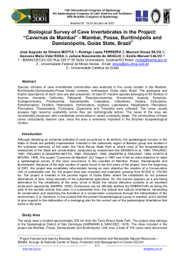
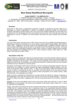
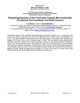
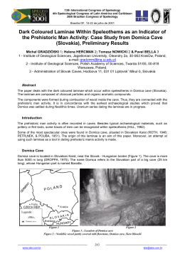
13th International Congress of Speleology
4th Speleological Congress of Latin América and Caribbean
26th Brazilian Congress of Speleology
Brasília DF, 15-22 de julho de 2001
Hydrogeology and Cave Explorations of the Lost River Dobra:
A Case Study of Underground Flow in the Dinaric Karst
Mladen KUHTA & Anđelko NOVOSEL
Institute of Geology, Sachsova 2, HR -10000 Zagreb, Croatia
e-mail: [email protected] ; [email protected]
Abstract
The Dinaric karst region covers about 50% of Croatian State territory. Due to well developed and diverse
karst forms, both on the surface and underground the area is known as "classical karst". One of the well
developed phenomenons are lost rivers, as the river Dobra in the NE part of the area. The Dobra River sinks
in the very town of Ogulin and after 4.5 km reappears as the strong karst spring Gojak. In the eighties, the
longest cave of Croatia has been explored at the entrance side, 16 391 m long Đulin ponor - Medvedica
Cave System respectively. Recent explorations are directed towards the Gojak spring where the 2 166 m
long Spring Cave Gojak has been discovered. The geomorphologic phenomenons of the area and its
genesis are the result of lithological characteristics of rocks, geological structure, hydrological and
hydrogeological relations. On this basis the possibility of further explorations and prospects for connection of
cave systems have been made.
Introduction
River Dobra is the classical example of the karstic lost river. Its upper course, known as the Ogulinska Dobra
which springs at the foothills of the Velika Kapela mountain, and sinks 30 km SE in the Đulin ponor at the
Ogulin-Oštarije karst platform. After sinking and 4.5 km of underground flow, reappears on the surface at the
strong permanent karstic spring Gojak. The lower part of the river, now known as the Gojaĉka Dobra, flows
in the NW direction where it joints the Kupa River. Large quantities of sinking water, which during the rainy
season discharge can surpass 100 m3/s, formed a complex network of cave channels in the karst
underground.
Review of Exploration
Đulin ponor and the nearby Medvedica Cave have been known to the local population long before since the
large cave entrances are located within the town of Ogulin. Initial speleological explorations were made by J.
Poljak between 1925 and 1935, when the first charting of the caves was done (POLJAK, 1926, 1935). The
next explorations were conducted
by M. Malez in 1954 and 1955 (MALEZ, 1956 a, 1957). The total length of caves was not significantly
increased, but his topographic plan was more precise than the former of Poljak and reported 750 m of
explored channels in Đulin ponor and as many in Medvedica Cave. The last exploration conducted by M.
Ĉepelak and cavers mostly from the "Velebit" Speleo Section and several from the "Željezniĉar" Speleo
Section, between 1984 and 1986, brought new unexpected results. The Đula Sinkhole and Medvedica Cave
have been explored and
connected in one 15 701 m long cave system (ĈEPELAK, 1987). The results of recent periodical
explorations are not so prestigious, but the total length increased to 16 396 m, making the Đulin ponor Medvedica System the longest cave of Croatia.
Hard caving and fairly reduced possibility of major discoveries in the upstream (entrance) part of the River
Dobra underground, directed explorations towards the outflow zone i.e., the Gojak spring. In the summer of
1998 the short entry siphon has been successfully passed. The following year members of the Caving Club
"Željezniĉar" explored a 2 166 meters long cave system, with a general strike in the southwestern direction
towards Ogulin and the system Đulin ponor - Medvedica (KUHTA et al., 2001).
-----------------------------------------------------------------------------------www.sbe.com.br
181
-------------------------------------------------------------------------sbe@sbe.com.br
13th International Congress of Speleology
4th Speleological Congress of Latin América and Caribbean
26th Brazilian Congress of Speleology
Brasília DF, 15-22 de julho de 2001
Fig. 1 Position of the study area
Morphology of the Caves
The complex network of the underground channels in Đulin ponor - Medvedica Cave System can be divided
in three general units. The first is dry during average water levels, and forms an web of channels between
Đulin ponor and the entrance passage of the Medvedica cave. This is a sort of filter that holds most of
sweepings driven underground by water stream during flooding. The second, medium part includes a main
channel with branches on several levels. The third unit forms several westward trending channels in the final
part of the cave. They have been developed under the influence of one strong tributary groundwater stream.
The vertical distance from the entrance of Medvedica (highest point of the cave, 315 m a.s.l.) to the lowest
point at the final siphon lake is 83.5 meters (Lake of the skinny frog, 231.5 m a.s.l.).
Strong hydrologic activity in the cave does not permit stalactite and stalagmite processing, but explicate
erosive formations are numerous.
Fig. 2 Shematic topographic plan of the Đulin ponor - Medvedica cave system
-----------------------------------------------------------------------------------www.sbe.com.br
182
-------------------------------------------------------------------------sbe@sbe.com.br
13th International Congress of Speleology
4th Speleological Congress of Latin América and Caribbean
26th Brazilian Congress of Speleology
Brasília DF, 15-22 de julho de 2001
With the total investigated length of 2166 m the Spring Cave Gojak is one of the most important speleological
phenomena in Croatia and the longest caves investigated behind a submerged siphon. About 15 meters long
and only 5 meters deep entrance syphon is located on 189 m a.s.l. In a morphological sense the Spring
Cave Gojak is a branched speleological object too. This is confirmed by the fact that 1410 m of underground
channels or 65% of total cave length was investigated in satellite channels. Since there are possibilities of
further investigation of some satellite channels this ratio will grow.
The general strike of the cave is in the southwestern direction towards Ogulin and the system Ðulin ponorMedvednica. The width of up to 20 m of the Main channel of the cave makes it an unique example of a
subsurface water flow in karst which is 756 m long. The channel terminates with a siphon lake deeper than
25 m. The large dimensions of the submerged part of the channel indicate a possibility of successful diving
through this obstacle and would allow further investigations of the cave. The most distant point reached from
the entrance along the main channel in a straight line is 575 m, and the elevation difference of water levels is
approximately 10.5 m.
Smaller caves are of simple morphology and they have not larger speleological importance, but they
completing understanding of genesis and development of hydrogeological relations on the area concerned.
Caves Skorašnik (24 m) and Drenovac (116 m) are the part of fossil sinkhole systems of the first and second
generation. It should be mentioned that the Drenovac cave has been discovered during hydroenergetic
tunnel excavation (MALEZ, 1956). The cave is located at the elavation of 297 m a.s.l. Vertical cave (pit) Kod
tri bora (- 63 m) is the deepest cave explored in the hilly area between Đulin ponor and Gojak spring, in the
zone of predominantelly vertical circulation respectively.
Very important is Sodolska cave explored in the length of 290 m. The cave functions as a periodical spring,
active during extremlly high water conditions.
Fig. 3 Topographic plan of the Spring Cave Gojak
-----------------------------------------------------------------------------------www.sbe.com.br
Fig. 4 Topographic plans of some smaller caves
183
-------------------------------------------------------------------------sbe@sbe.com.br
13th International Congress of Speleology
4th Speleological Congress of Latin América and Caribbean
26th Brazilian Congress of Speleology
Brasília DF, 15-22 de julho de 2001
Geology
The cave systems are formed in the distinctive karst morphology of the Ogulin area. The geological structure
is mainly composed of Jurassic and Cretaceous dolomite and limestone layers. The largest Đulin ponor Medvedica Cave System and Spring Cave Gojak are completely formed within the Aptian (K 14) foraminiferalalgal limestone. The central part of a symmetrical syncline structure between them, the hilly area
respectively, is composed of Albian (K15) foraminiferus limestones. In the regional sense the area is a part of
large nappe structure related to the tangential tectonic movements during the so called Middle Eocene
Pyreneean orogenetic phase. The predominantly dinaric northwest - southeast trending structures; folds,
normal and reversal faults, have been effected by younger, mainly block tectonics.
Hydrogeological Relations
The Đulin ponor-Medvedica Cave System is a natural drainage channel for the water of the lost river
Ogulinska Dobra and its tributaries. Its catchment area is about 380 km2, with the mean annual precipitation
of 1700 mm. Typical karstic features of the river are well expressed by the discharge ratio which varies from
0.12 m3/s to 154 m3/s. The mean annual flow rate is 9.7 m3/s. The natural hydrological conditions have been
drastically changed at the beginning of sixties, when the Bukovnik Dam and reservoir at the upstream part of
Dobra river have been constructed (about 2 km from the Đulin ponor entrance), and water transferred by a
diversion tunnel to the Gojak Hydroelectric Power Plant, located nearby the Gojak spring. After that time,
only during the rainy season or exceptionally heavy rain events, water sinking in the natural drainage system,
the Đulin ponor - Medvedica Cave System respectively. The mentioned changes did not influence or obstruct
the study of hydrogeological relations and genesis of the largest cave system in Croatia. Moreover, in some
aspects they contributed to explorations (physical caving).
The present situation is only one stage in the frame of permanent karstification processes. Geomorphological
phenomena are a direct result of the lithological characteristics, geological structure, hydrgeological
properties of rocks and the changes in hydrological and metereological conditions, particularly during the
Quaternary. The relief forming processess must be considered dynamiclly, through time, becouse the
present state is only a momentary reflex of the interaction of endogenous and exogenous processes. The
material traces in the shape of morphological phenomena and younger sediments (river valleys, river
terraces, underground phenomrna etc.) enable at least a partial reconstruction of the geomorphological
development of a terrain and, more importantly provide insight into the genesis of the actual hydrological
relationships and groundwater dynamics.
The northern side of the Ogulinsko polje shows visible traces of earlier streams that followed almost in the
same direction as the cave system toward area of old sinkholes. The first generation of sinkholes is located
slightly above the present polje level. The physical remnants are rare, but the cave Skorašnik confirmed their
existence. The sinkholes of the second generation are developed along the northeastern border of Ogulinsko
polje, immediately along the foothills of morphological barrier toward Gojak spring area, at an elevation range
from 315 to 320 m a.s.l. Boulders and young Quaternary deposits fill the entrances and caving explorations
are not possible. The remnant, or better to say, a part of the second generation sinkholes is the cave
Drenovac discovered on the route of the diversion tunnel, deeper in the carbonate massive (297 m a.s.l.). the
Đulin ponor - Medvedica cave system belongs to the third, the most developed generation of sinkholes. The
elevation of the Gojaĉka Dobra riverbed in the canyon in front of the entrance of Đulin ponor is about 273 m
a.s.l. The karstification processes are advancing and the fourth generation of sinkholes is apearing in the
upstream part of Dobra riverbed (Hreljin, 5 km NW). Today, these sinkholes are in shape of slightly widened
fractures, causing some water loses from river and the reservoir.
During normal hydrological conditions, before the dam construction, the lost river Ogulinska Dobra was
permanently sinking through the entrance of Đulin ponor and the fourth generation of sinkholes. At present
the downstream part of riverbed is mostly dry, and only the youngest, upstream sinkholes are active. The
fourth generation of sinkholes is connected with the older Đulin ponor-Medvedica cave system and collects
the water which appears deeper in the cave as permanent underground flows, even when the entrance is
dry. It seems that the underground flow in the second unit of channels is related on water loses from
reservoir area. Strong underground inflow observed in the third unit probably is connected with upstream
sinkholes near Hreljin. This water flows through still unknown passages of the karstic system and reappears
on surface through the Spring Cave Gojak.
-----------------------------------------------------------------------------------www.sbe.com.br
184
-------------------------------------------------------------------------sbe@sbe.com.br
13th International Congress of Speleology
4th Speleological Congress of Latin América and Caribbean
26th Brazilian Congress of Speleology
Brasília DF, 15-22 de julho de 2001
Fig. 5 Geological map of the investigated area (after: VELIĆ & SOKAČ, 1981). Legend: 1) foraminiferus limestone; 2)
foraminiferal-algal limestone; 3) limestone and dolomite; 4) algal-foraminiferal limestone and dolomite; 5) syncline axis; 6)
faults; 7) relatively descended block; 8) bedding; 9) simplified plan of the most important caves; 10) cave and pit (jama) entrance;
11) area of the first generation sinkholes; 12) area of the second generation sinkholes; 13) general groundwater flow direction;
14) groundwater flow from the sinkholes of the fourth generation
During the rainy season the reservoir capacity is to low and the overflow sinks in Đulin ponor - Medvedica
Cave System. After heavy rains, and snow melting, the discharge of Ogulinska Dobra River increases to the
more than 100 m3/s. Under such conditions, the discharge capacity of the cave system is to low to accept all
the water, and also the outflow capacity of the Gojak spring is restricted. The level of Ogulinska Dobra at the
entrance of Đulin ponor rise in these cases more than 40 m. Occasionally the Dobra River flows over the
canyon flanks and floods some parts of Ogulin city. The highest observed level was 322 m a.s.l. (+49 m).
Finally a part of water flows through the fossil riverbeds toward the sinkholes of the second generation on the
NE edge of Ogulinsko polje and activates the old underground drainage system. As a consequence, the
Sodolska cave located on elevation of 230 m a.s.l., 41 m over the Gojak spring (189 m a.s.l.) respectively,
becomes active too with discharge of several m3/s.
The hydraulic connection between Đulin ponor and spring Gojak has been proved by a tracer experiment
carried out with uranin during a low discharge season (2 m3/s) in 1948. All relevant springs in the area have
been observed but the tracer was detected only on Gojak spring; 84 % of injected tracer reappeared, the
underground flow velocity was 5.4 cm/s. The cavers main interest is the possibility for further explorations
-----------------------------------------------------------------------------------www.sbe.com.br
185
-------------------------------------------------------------------------sbe@sbe.com.br
13th International Congress of Speleology
4th Speleological Congress of Latin América and Caribbean
26th Brazilian Congress of Speleology
Brasília DF, 15-22 de julho de 2001
and prospects for the connection of cave systems. Taking in account the indentation of already explored
caves, the whole system should be longer than 50 km.
Based on the results of speleological exploration the main geometrical parameters of the karst underground
were determined. The distance between terminal siphons in the Đulin ponor-Medvedica (231.5 m a.s.l.) and
Spring cave Gojak (200.5 m a.s.l.) is 3250 m, with a vertical difference of 31 m, with a hydraulic gradient of
9.5 ‰. For the comparasion the general gradient of Đulin ponor -Medvedica (from the lowest entrance to
terminal siphon) is 39 ‰ and 18 ‰ in Spring Cave Gojak.
In spite of the fact that the area between them is composed of permeable foraminiferus limestones the
geological situation is generally unfavorable. The main tectonic discontinuities strike NW -SI and are
perpendicular to the groundwater flow direction. They were formed during the last kinematic stage of the
contraction tectonic phase, and from the hydrogeological point of view they act as local barriers and disperse
the groundwater flow.
Hydrogeological observations indicate that the discharge increase of Ogulinska Dobra river is accompanied
with high water turbidity, but at the same time, the turbidity of the Gojak spring is changes slightly. It was also
observed that when the river overflows its banks and water reachs the sinkholes of the second generation,
from the Sodolska cave an outflow of large quantities of muddy water occures.
In wiev of all these facts, the area between Đulin ponor - Medvedica Cave System and Spring Cave Gojak
somewhat slander channels and deeper sifonal circulation are expected to occur. Some progress will be
done in the zone of permanent circulation, but the siphons would be deeper and longer. The behavior of the
karstic system during flooding, and remnants of old caves indicate that real prospects are related to
exploration of inactive or periodically active channels, located on several levels over the zone of permanent
circulation. In an such intensively karstified area, mutual connection of these levels is very probable. Maybe
the entrance to thit system is the unexplored terminal siphon of the Sodolska cave.
References
ĈEPELAK, M. 1987. Cave System Đula - Medvedica. Speleolog 32/33 : 2-24.
KUHTA, M., JALŽIĆ, B. & NOVOSEL. A. 2001. Spring Cave Gojak. Speleolog 46/47 : 3-11.
MALEZ, M. 1956. Cave Drenovac. Speleolog 3/4 : 52-56.
MALEZ, M. 1956 a. Đulin ponor in Ogulin. Geološki vjesnik 8/9 : 169-172.
MALEZ, M. 1957. Cave Medvedica (Ogulin). Geološki vjesnik 10 : 71-82.
POLJAK, J. 1926. Geomorphology and hydrography of the Ogulin and Ogulinsko Zagorje area. Glasnik
hrvatskog prirodoslovnog društva. Vol. 37-38.
POLJAK, J. 1935. Pećine okolice Ogulina, V. Paklenice i Zameta. Rasprave Geol. instituta kraljevine Jug. 5
: 81 p.
VELIĆ, I. & SOKAĈ, B. 1981. Basic geological map 1:100 000, section Ogulin.
-----------------------------------------------------------------------------------www.sbe.com.br
186
-------------------------------------------------------------------------sbe@sbe.com.br
Download