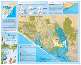
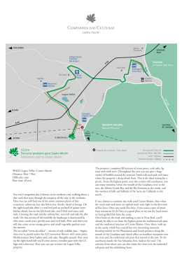
A 22
CORTE ANTÓNIO
MARTINS
CASTRO
MARIM
Ribeiro
do Álamo
N 125-6
CC S.Bartolomeu
2
A2
SAGRES
Santa Rita
Portela
EN 1
1
Fonte
Santa
Altura
25
Cabeço
Xico
2
Vila Nova
de cacela
Praia Verde
3
V.R.S.A.
Sem
Espinhas
Chaminé
Manta Rota
Chá com
Água Salgada
EN 1
25
Martins
Cacela Velha
TAVIRA
Fábrica
CC
BAÍA DE MONTE GORDO
Bay of Monte Gordo
SA
e
MO
OR eserv
F
RIA ural R
Nat
8 km
Percurso pedestre para Cacela Velha/Ria Formosa
Pedestrian path to Cacela Velha/Ria Formosa
1
CIIPC / Centre for Research and Information
2
Estação de comboios / Train station
3
Farmácia / Pharmacy
Percurso #6 / Path #6
A 22 / Highway
EN 125 / EN 125
Caminho de ferro / Railway
WALK: Cacela Velha/Ria Formosa
Distance: 8km
Difficulty: easy
Best time: all year
You exit Companhia das Culturas via its northern end, walking down a
dirt track that runs through the property all the way to the wetlands.
Here you can still find one of the most common plants of this
ecosystem, salicornia, but also bittercress, thistle, chard or borage. On
the right-hand side there's a reed bed and an orchard of quince trees
and, further ahead but on the left-hand side, you'll find reed mace and
rush lining an asphalt road that runs parallel to the railway line. Turn
left. This road runs along the last manifestation of the barrocal
(sub-region between the Serra and the coast) in this corner of the
Algarve. Some 500 metres north begins the so-called “terras de talisca”
– terrain of soft, reddish slate. Apart from some spontaneous vegetation like the thyme you can see on the right-hand side of the road, the
area is dominated by orange groves and horticulture. Once the road
crosses the small bridge over the railway it takes the direction of Vila
Nova de Cacela. Old rain-fed orchards reappear here, with carob, fig,
olive and almond trees. The Ribeiro do Álamo valley is dominated by
almond trees which bloom in January. Once you're reached Vila Nova
de Cacela, any of the three cafés on the left-hand side of the main
crossroads are a good place to try out some of the best regional
sweets and pastries.
Walking on in the same direction you'll soon cross the EN125 main
road. Some of the region's most fertile lands can be found around
this area. The landscape was shaped during the Islamic period,
mainly based on rain-fed orchards and also cereal crops. Upon
reaching Cacela Velha you'll come across an urban settlement of
Islamic matrix and a fine example of traditional southern architecture. The fort, rebuilt in the 18th century right after the earthquake,
evokes the days of piracy. “There were defensive structures in the
place at least since the 10th century. And surveillance of the coast
became the fort's prime mission right after the Reconquest: the local
inhabitants would take shelter there upon hearing the bells sounding
the alarm when privateers approached in their constant raids.”
From the wall you can see the Ria Formosa, which from here
extends 60km to the west all the way to the Ancão river in Loulé. It
comprises some 18,400 hectares.
Download